
Plate A37.01- So far, in this offshore, as well as, in the onshore there are no evidence the SDRs. However, as illustrated in the next plate, the present of an important salt layer and the associated halokinesis can mask the evidence of seaward dipping reflectors, as it is case in certain areas of the Angola offshore (see later).

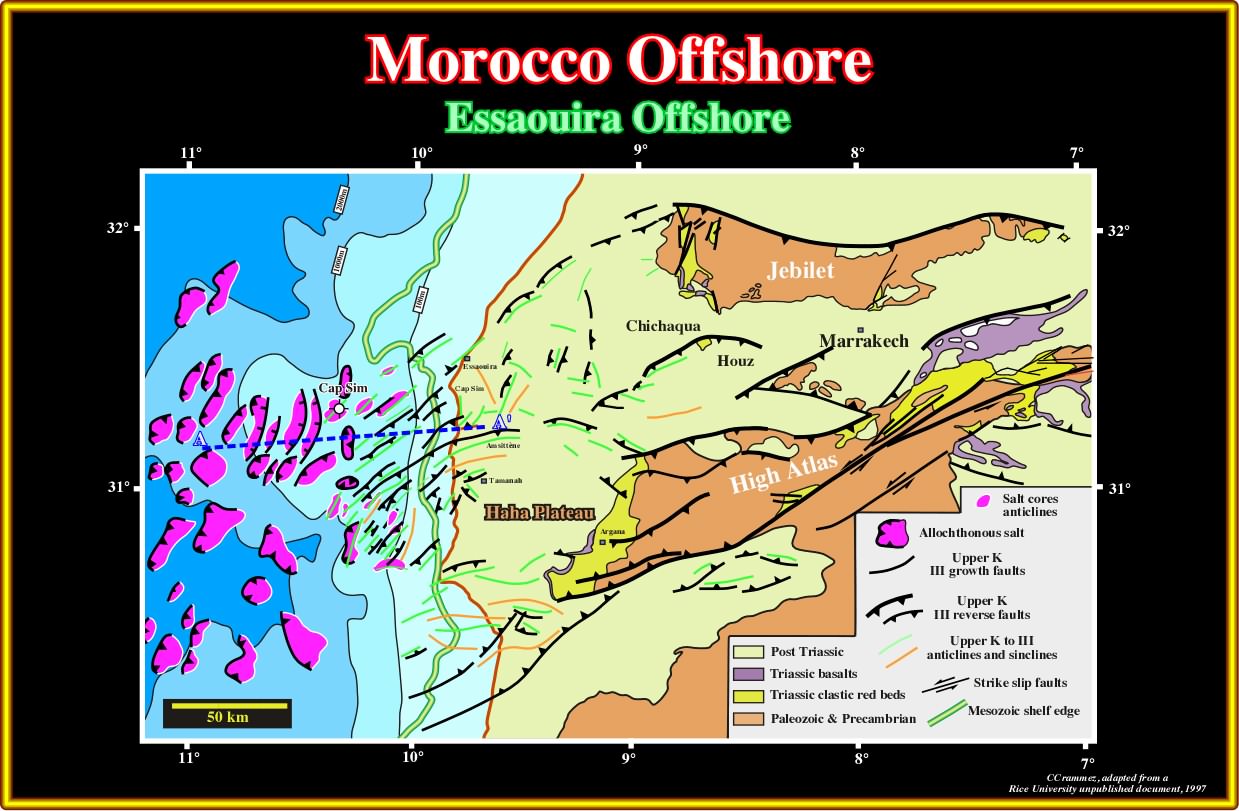
Plate A37.02- In this tentative interpretation of a composite seismic line (Essaouira basin), the shortening of the sediments (compressional tectonic regime), the halokinetic deformation (lengthening) and the quality of the lines /too many multiples) are not favourable to the recognition of potential SDRs.
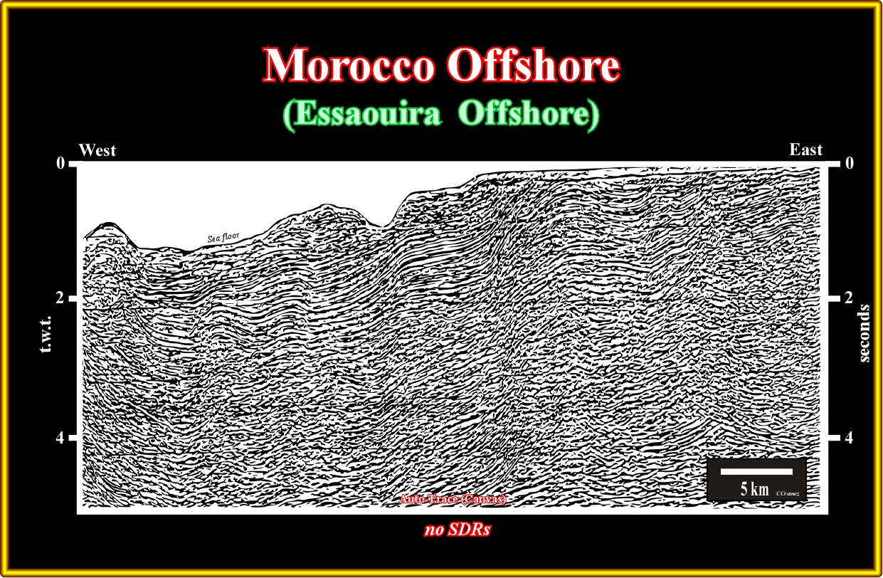
Plate A37.03- In fact, as illustrated on this line, one can always recognize SDRs (seaward dipping reflectors) but their volcanic facies is quite questionable.
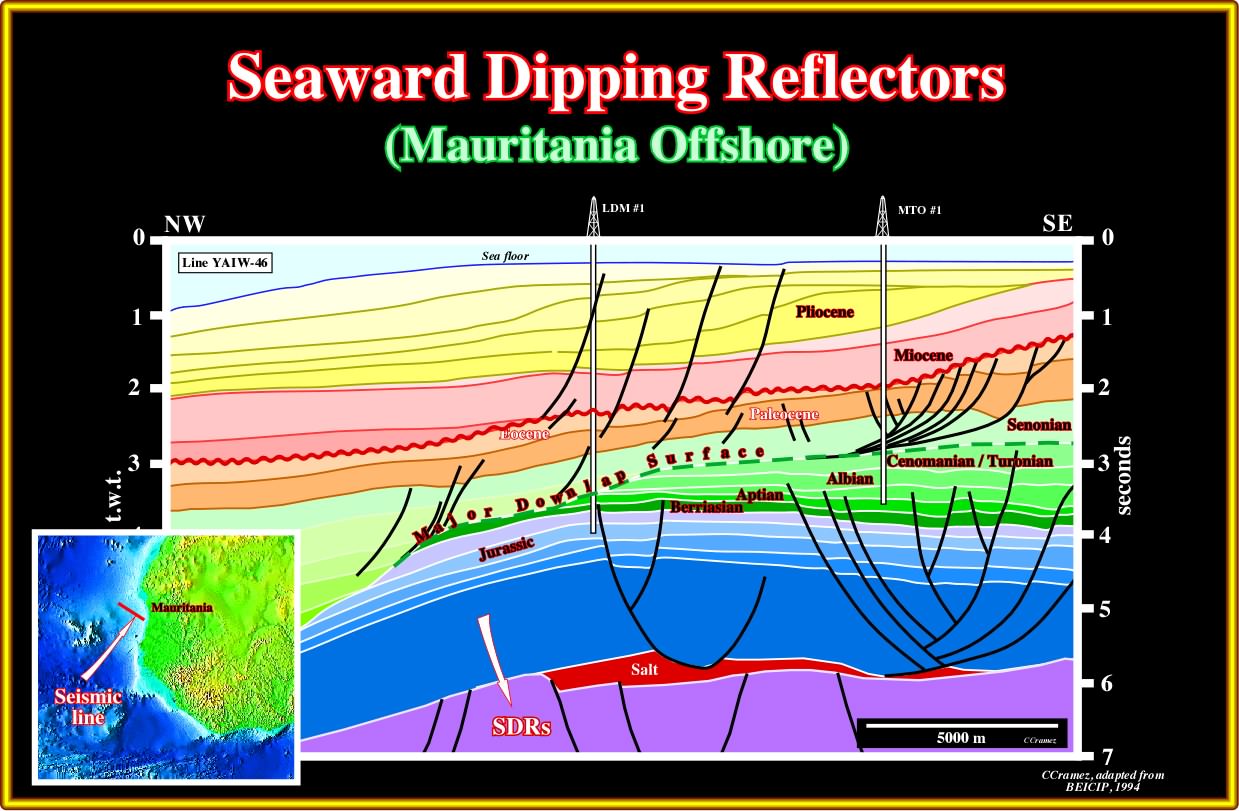
Plate A38.01- In this tentative interpretation, the salt layer located above the SDRs (subaerial lava flows dipping seaward) has a composition that can be explain as a consequence of a chemical reaction between sea water and basaltic material of the lava flows, as said previously.
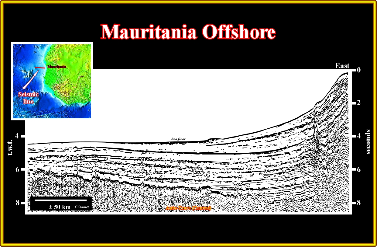
Plate A38.02- On this regional seismic line, the oceanic crust is obvious, in the central and western part of the line, but there is not a strong evidence of SDRs in the lower eastern end of the line.
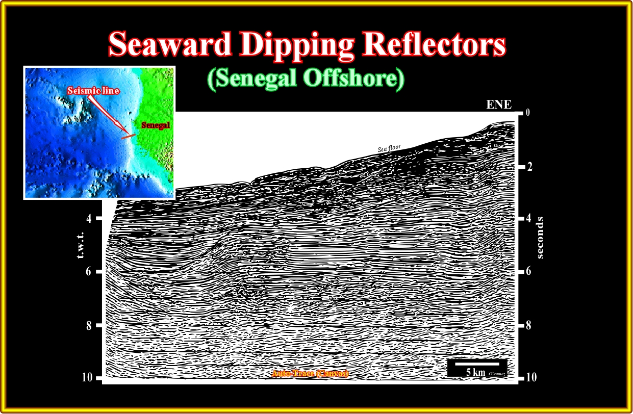
Plate A39.01- As illustrated in the next plate, the substratum of the margin sediments is assumed to be composed by subaerial lava flows, but the proposed tentative interpretation can be refuted easily by new data. In other words, there is no data corroborating such SDRs interpretation.

Plate A39.02- This margin stratigraphy proposed in this tentative interpretation seems quite coherent. It is partly corroborated by the exploratory well drilled near the eastern end of the line. The volcanic structure (probably a volcano) is not refuted by magnetic data, which suggests an anomaly at the western end of the line.
A40- Guinea-Bissau / Sierra Leone / Liberia Offshore:

Plate A40.01- This regional cross-section (based on seismic data) assume the presence of SDRs between the oceanic crust and the Gondwana (southern continent of the Pangea supercontinent). In fact, the composition of the salt (Triassic in age) deposited at the bottom of the divergent margin, is easily explain if the brine lies above volcanic rocks.
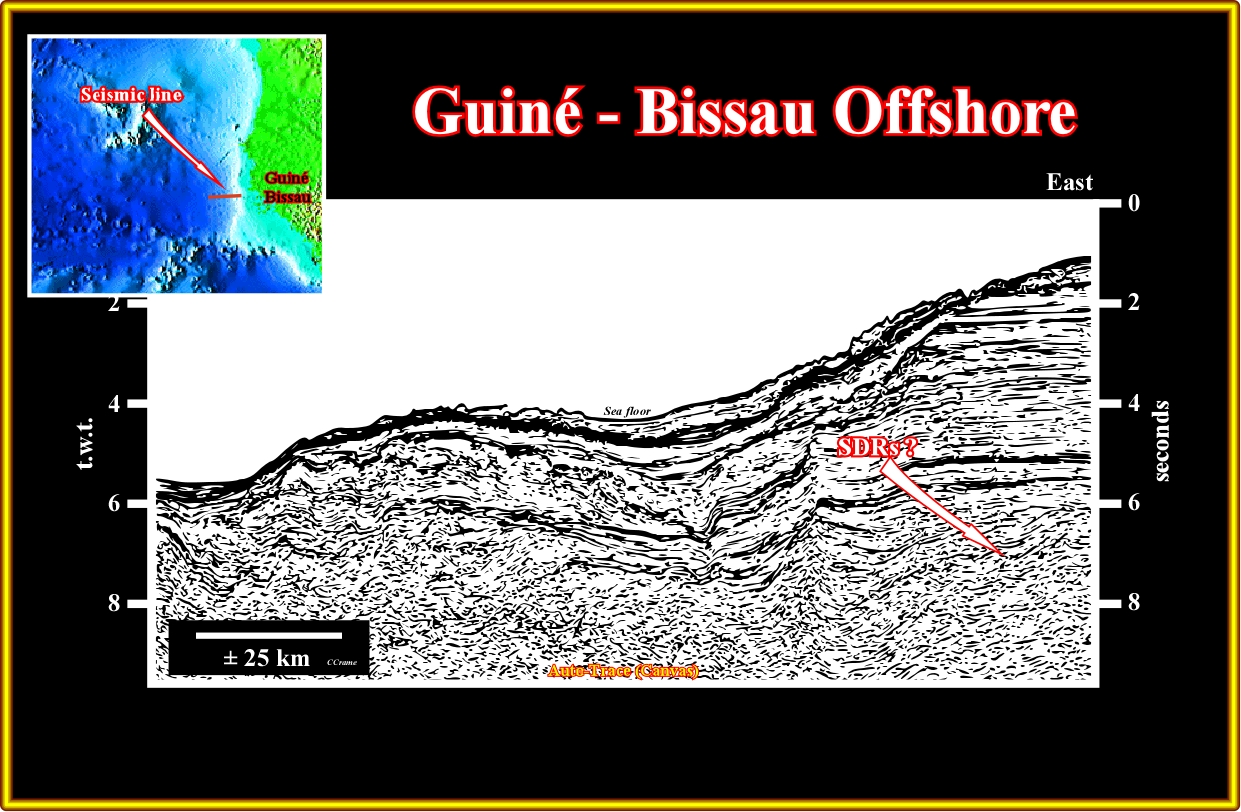
Plate A40.02- On this seismic line, it is not too difficult to recognize SDRs in the lower eastern end of the line.. However, such interpretation must be tested by other data.
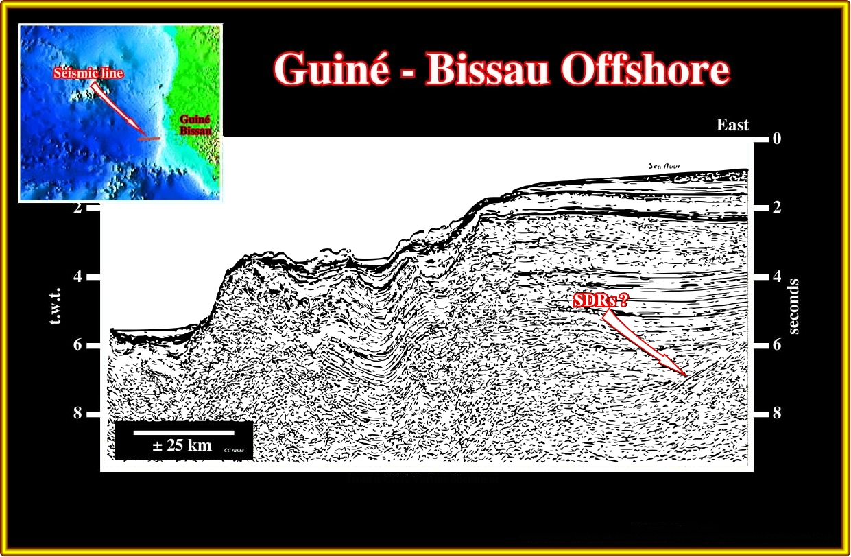
Plate A40.03- As in the previous seismic line, the presence of SDRs is likely in the lower eastern end, but its volcanic facies is highly hypothetical.
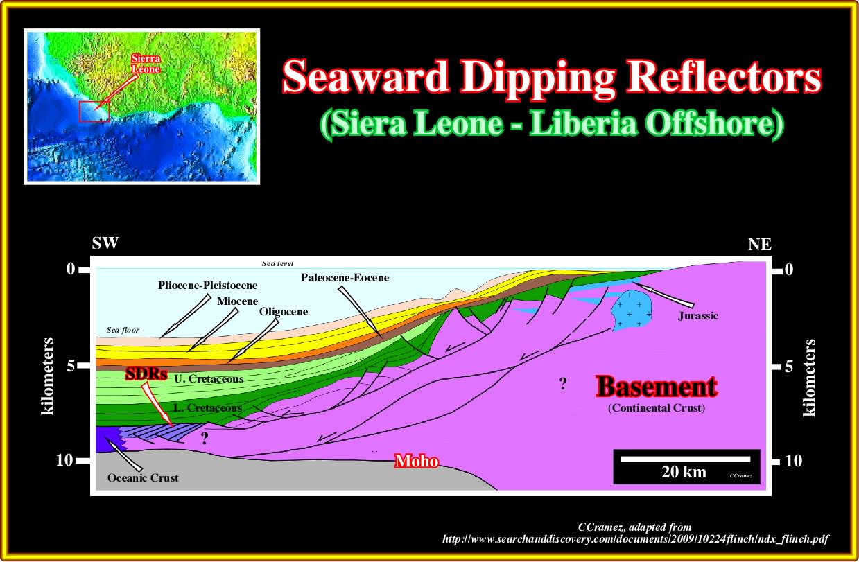
Plate A40.04- On this cross-section based on seismic data, SDRs are possible present, as indicated, between the oceanic crust and the continental crust.
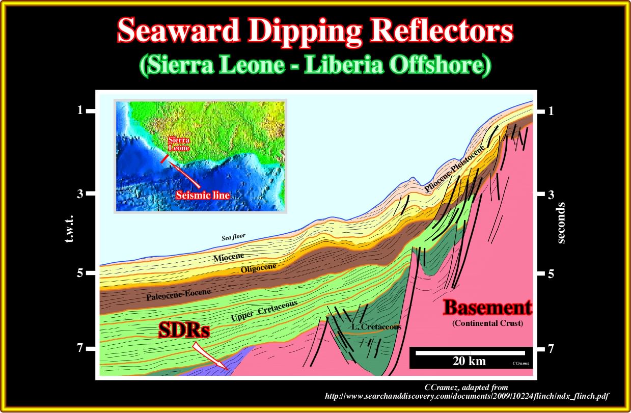
Plate A40.05- The presence of SDRs is likely as indicated in this tentative interpretation of a regional line of Sierra Leone - Liberia offshore, where the influence of the major fracture zones must be taken into account in the SDRs recognition.
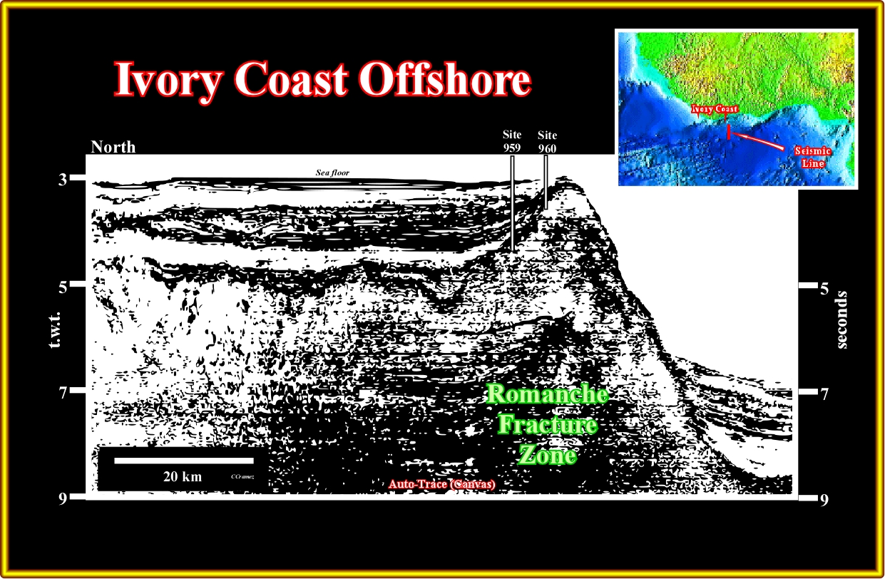
Plate A41.01- On this seismic line, the bathymetric change induced by the Romanche fracture zone is obvious. In this area (Gulf of Guinea), the offshores can be considered as transform margin, which difficult the recognition of the SDRs, since regional line cut different geological provinces separated by fracture zones.

Plate A41.02- This North-South seismic line, recognize two geological provinces individualized by fracture zones, as a consequence there is not a significant continuity of the reflections, which makes difficult too see the seaward dipping and the continentward thinning of potential lava flows.
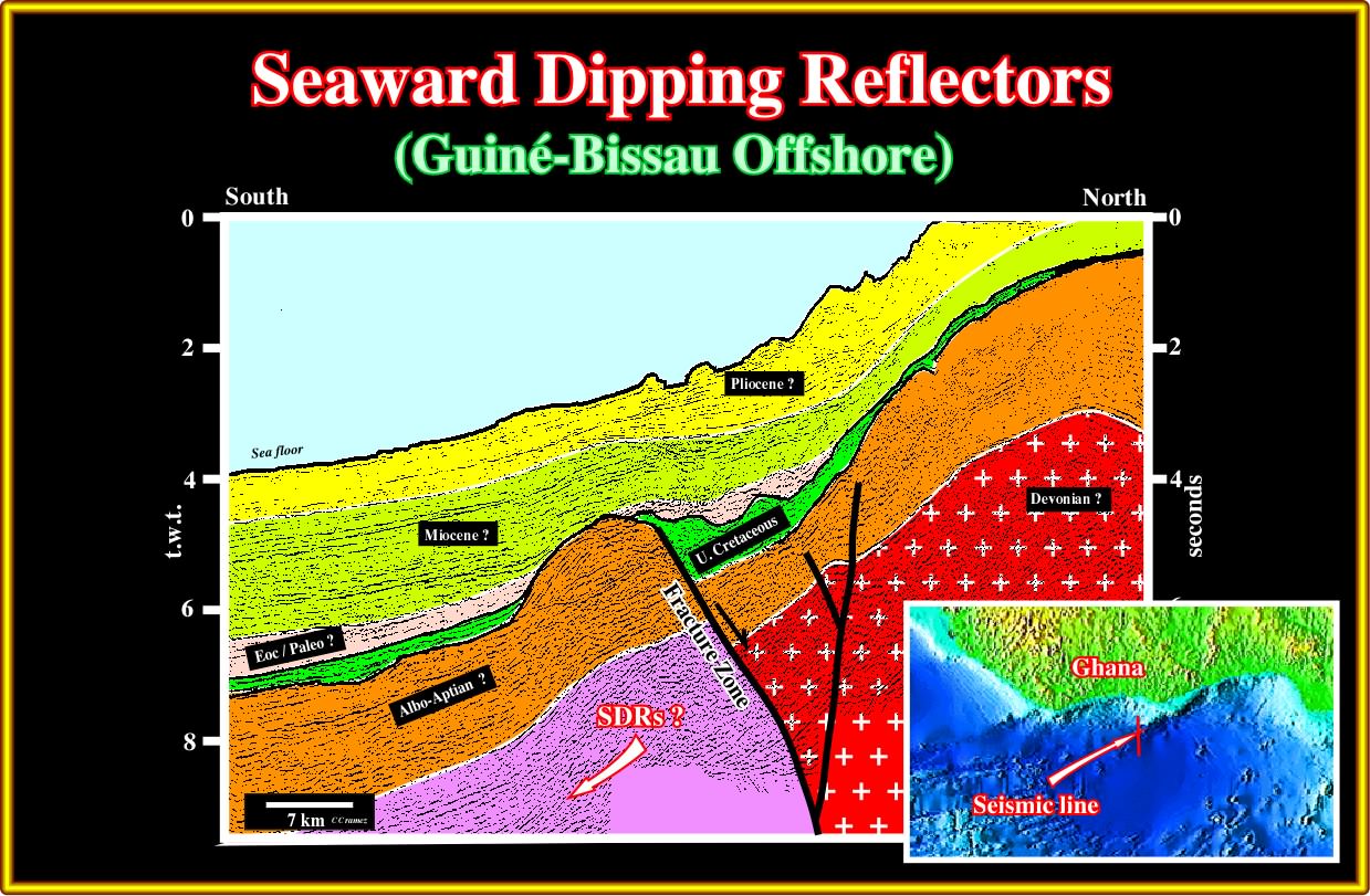
Plate A42.01- In this seismic line, if there are seaward dipping reflectors associated with subaerial lava flows they will be in the lower western part of the line seaward of the fracture zone.
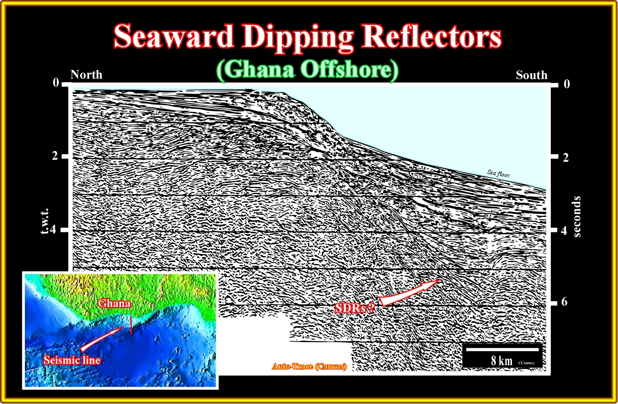
Plate A42.02- On this old seismic line, SDRs are likely as indicated, that is to say, above Paleozoic sediments and below the margin sediments.
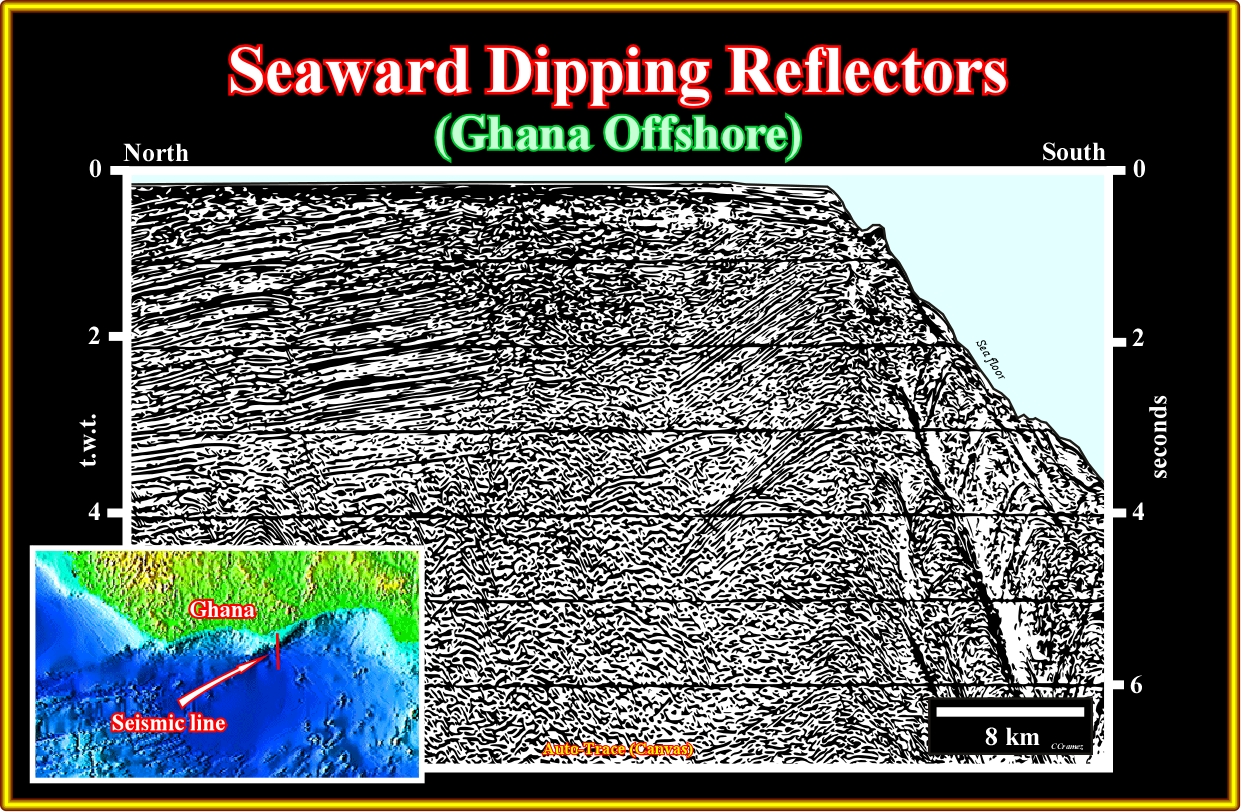
Plate A42.03- The influence of the fracture zones is here quite obvious, not only in the pre-Pangea sediments, but in margin sediments (upper continental slope).
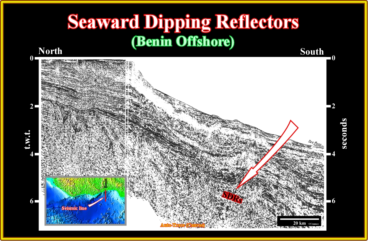
Plate A43.01- On this seismic line, highly affected by the fracture zones associated with the sea floor spreading, the SDRs are quite evident, in spite of the fact that they are, locally, deformed by the motion of the fracture zones, as illustrated next.
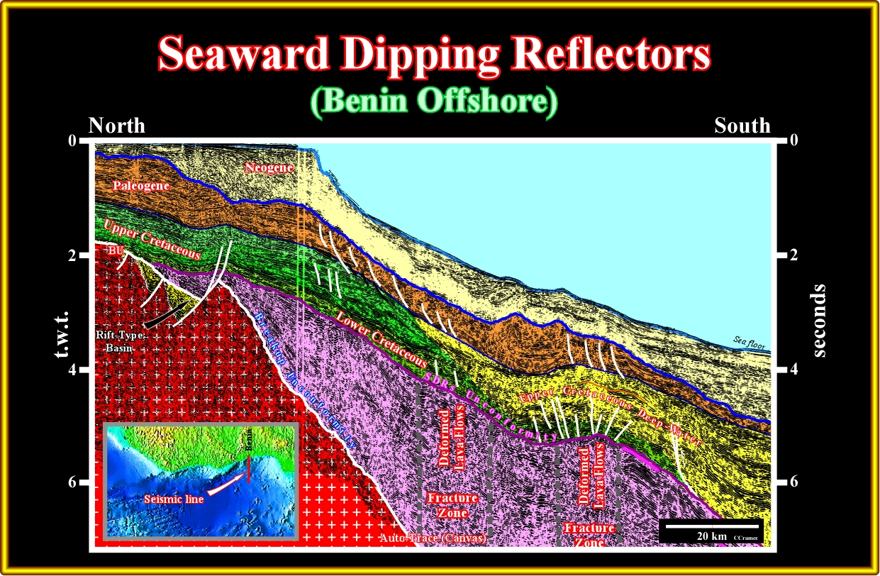
Plate A43.02- On this tentative interpretation several features have tremendous consequences on the hydrocarbon potential of the deep-water offshore of this margin. Firstly, the seaward dipping reflectors located seaward of the continental crust (Paleozoic or/and Precambrian) are interpreted as post-breakup lava flows without generating hydrocarbon potential. Secondly, the rift-type basins (in yellow) are too small and located within the continental crust, that is to say, landward of the actual shelf break. Thirdly, the Cretaceous transgressive interval (green), where potential marine source-rock intervals are located, is present. It has a backstepping geometry. However, its burial (taking into account the water depth) does not seems to be appropriated. Lastly, the reactivation of the fracture zones deformed the overlying sediments inducing morphological traps by juxtaposition and structural traps.
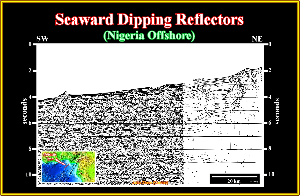
Plate A44.01- In this composite line of the Nigeria offshore, the SDRs are not obvious. Likely, as illustrated in the tentative interpretation (next plate), if the SDRs are present in this offshore, they will be in eastern part of the oceanic crust.

Plate A44.02- As one can recognize the quality of the eastern line of this composite seismic line is too poor and the more likely is that the reflections indications under the margin sediments correspond to multiples.

Plate A44.03- As in previous seismic line, here again there is not evidence of the Seaward dipping reflectors, that is to say subaerial lava flows.

Plate A44.04- In fact, in this area, the majority of the old seismic lines are not deep enough to recognize the SDRs even if they are presents.
A45- Equatorial Guinea Offshore:
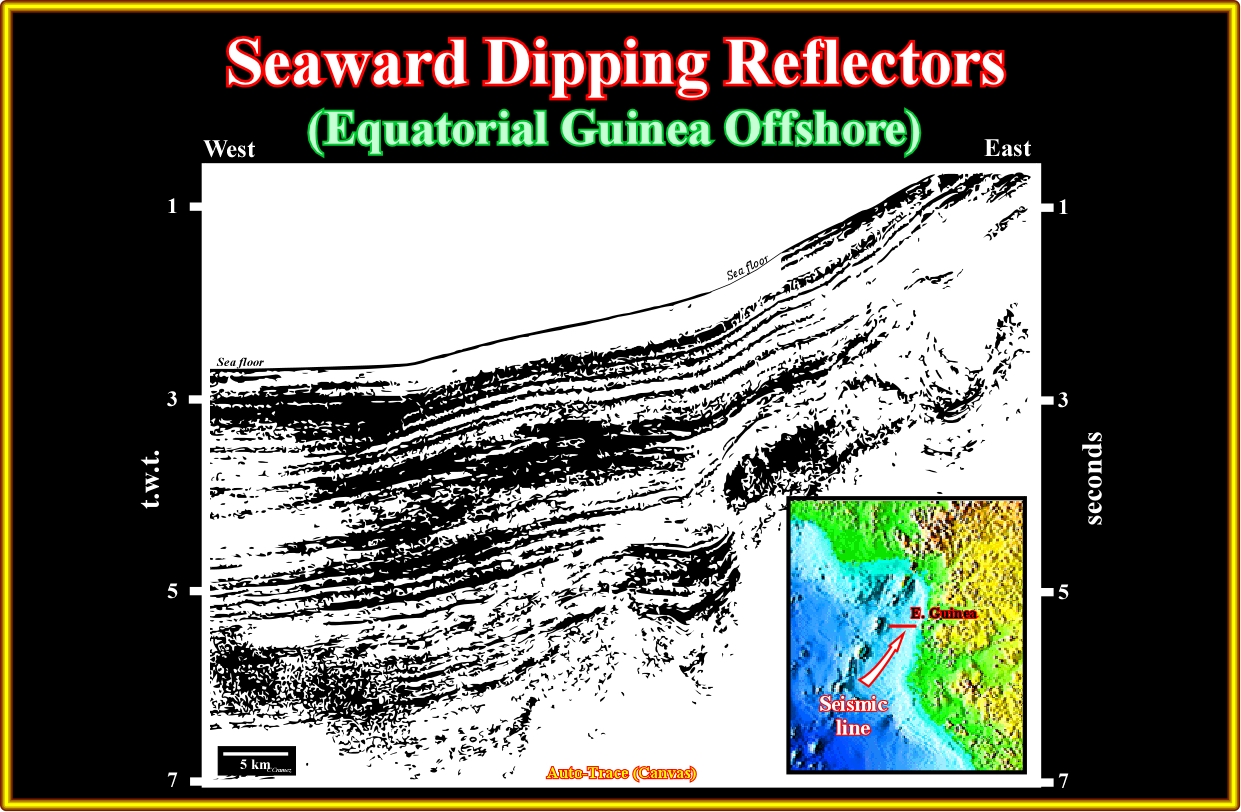
Plate A45.01- Taking into account the presence of major fracture zones and how they can disturb the pre- and post-breakup sediments sediments. The presence of the SDRs (subaerial lava flows) is likely, as depicted in the tentative interpretation illustrated in the next plate.
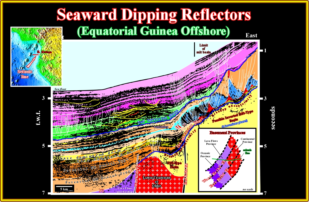
Plate A45.02- On this tentative interpretation, the West-Kribi fracture zone separates the SDRs of the continental crust. The schematic model on the left lower part of this plate, shows how the orientation of the seismic lines in relation to the fracture zones must be taken into account if one wants to recognize the SDRs in this offshores, where the fracture zones are quite obliques to the shoreline.
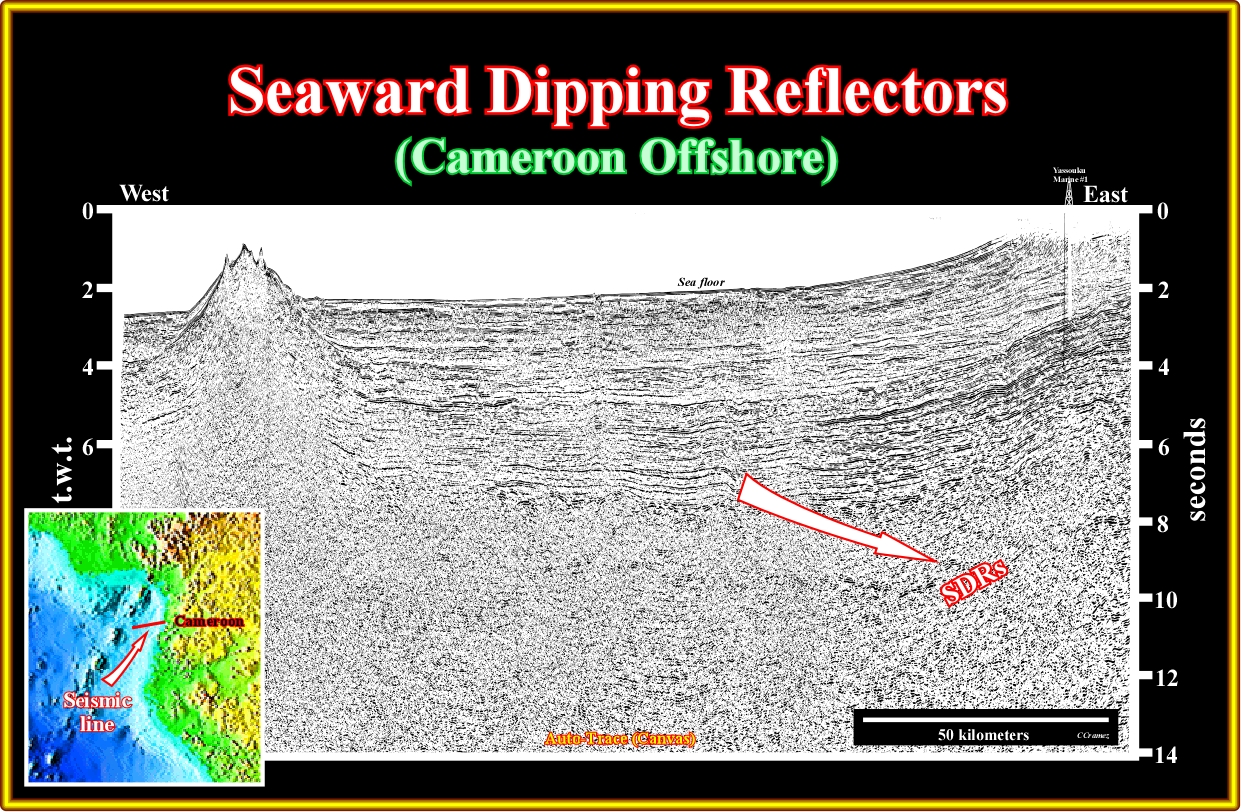
Plate A46.01- On this line, it is evident that the substratum of the margin has a volcanic facies (lithology). Landward of the eastern fracture zone, which is easily recognized by the associated compressional deformation of the margin sediments, the volcanic crust is mainly sub-aerial. Seaward dipping reflectors and lava-delta are quite evident. Seaward of the fracture zone, the hummocky geometry of the top of the infrastructure strongly suggests a oceanic crust.
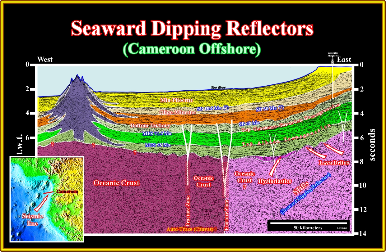
Plate A46.02- In this tentative geological interpretation we tried to put in evidence the major regional stratigraphic events of the South Atlantic margins, that is to say, the principal Mesozoic flooding surfaces, the Mesozoic-Cenozoic limit and the three continental encroachment stratigraphic sub-cycles building the Neogene sedimentary package. The SDRs (subaerial lava flows) and the associated lava-deltas are quite obvious on the lower eastern part of the line.
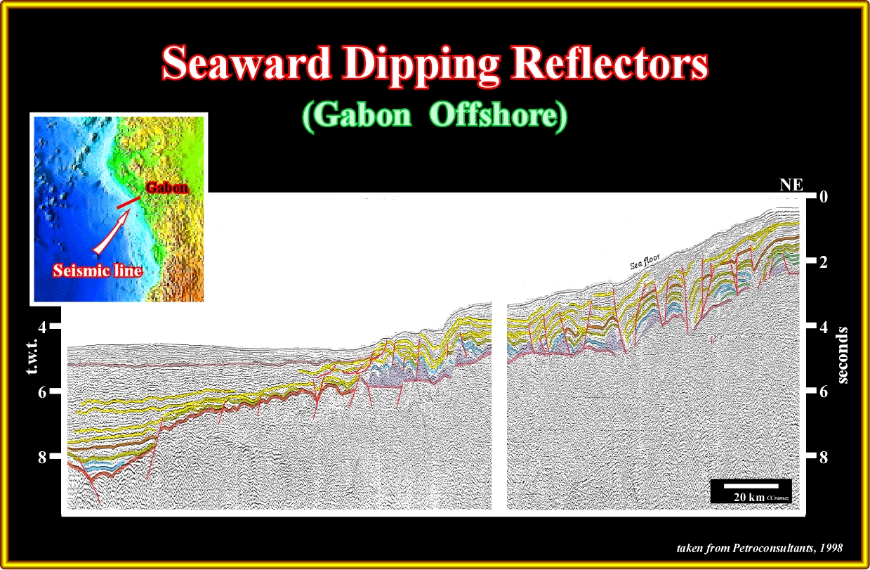
Plate A47.01- The quality and penetration of the old seismic lines is not good enough to recognize the SDRs. In addition the presence, even in the deep offshore, of a strong halokinesis can also be invoked to explain the no recognition of the subaerial lava flows.
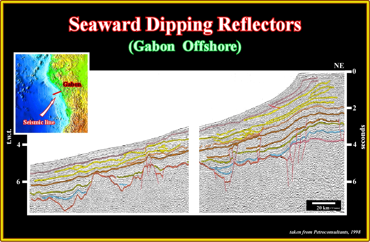
Plate A47.02- As in the previous seismic line, the quality and penetration of the old seismic lines is not good enough to recognize the SDR, even in the areas where halokinesis is almost inexistent.
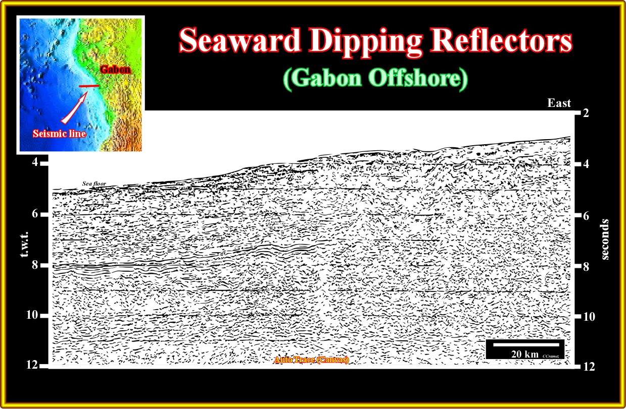
Plate A47.03- On this recent and deeper seismic line, SDRs are likely in the western lower part of the line, as better suggested in the next plate, since the line is better oriented.

Plate A47.04- On this megaregional line of the offshore Gabon, the SDRs are more difficult to refute, since the seismic line does not cross any major fractured zone. In fact, as the majority of the scientists know, the major fracture zones (transfer faults) strongly affect the COB (see plate 49.01).
A48- Congo-Angola Offshore (Congo Basin):

Plate A48.01- These SDRs are quite evident in north Angola offshore even under a thick salt interval, as illustrated here above.

Plate A48.02- In this uninterpreted recent seismic line, the SDRs (seaward dipping reflectors very often underlying subaerial lava flows are visible readily, even below, below a salt induced folded-belt.
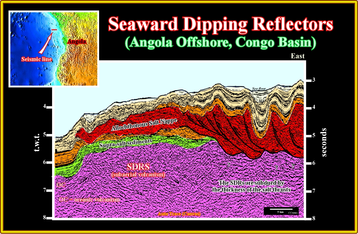
Plate A48.03- In this tentative interpretation of the previous line, the SDRs are quite obvious and difficult to refute (take into account the pitfalls induced by the lateral thickness variations of the salt due to the stacking of the thrust faults.
A49- Angola Offshore (Kwanza Basin):

Plate A49.01- On this sketch, where the COB is mapped, one can recognize the influence of the strike major fracture zones in the recognition of the seaward dipping reflections in Angola offshore, where they strike, more or less, N 45° E. The tentative interpretations of lines A, B and C are highly instructive.
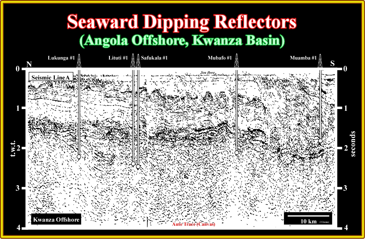
Plate A49.02- On this seismic line, the SDRs are not evident. However, they were recognized by drilling. On the contrary, as, depicted on the next pate, the Mijuca fracture zone, abruptly, separates the continental crust (with a rift-type basin) from the thick volcanic interval (subaerial lava flows).
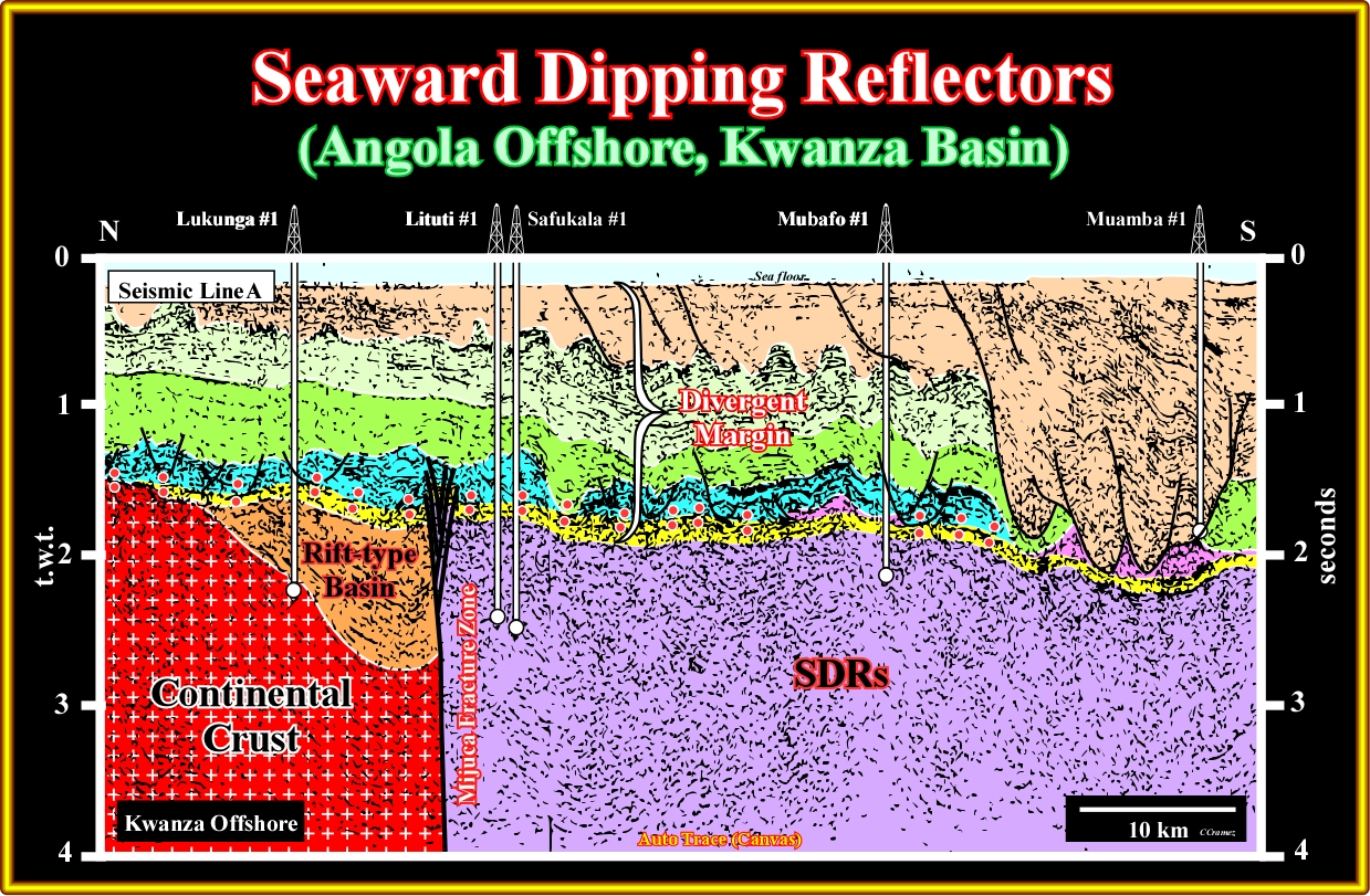
Plate A49.03- The Mijuca FZ is well illustrated by this north-south seismic line located on the southern part of the block 5 of the Kwanza offshore.. Northward of the Mijuca, the continental crust and a rift-type basin are quite obvious. On the contrary, southward, the continental crust is either very deep (three exploratory wells recognized several hundred meters of volcanics) or eastward as suggested by the seismic line B (next plate).

Plate A49.04- This seismic line corroborates the typical structural behaviour of thick intervals of subaerial lava flows. In fact, it is to recognize that they dip and thick seaward, that is to say, in direction of the subaerial spreading centres.
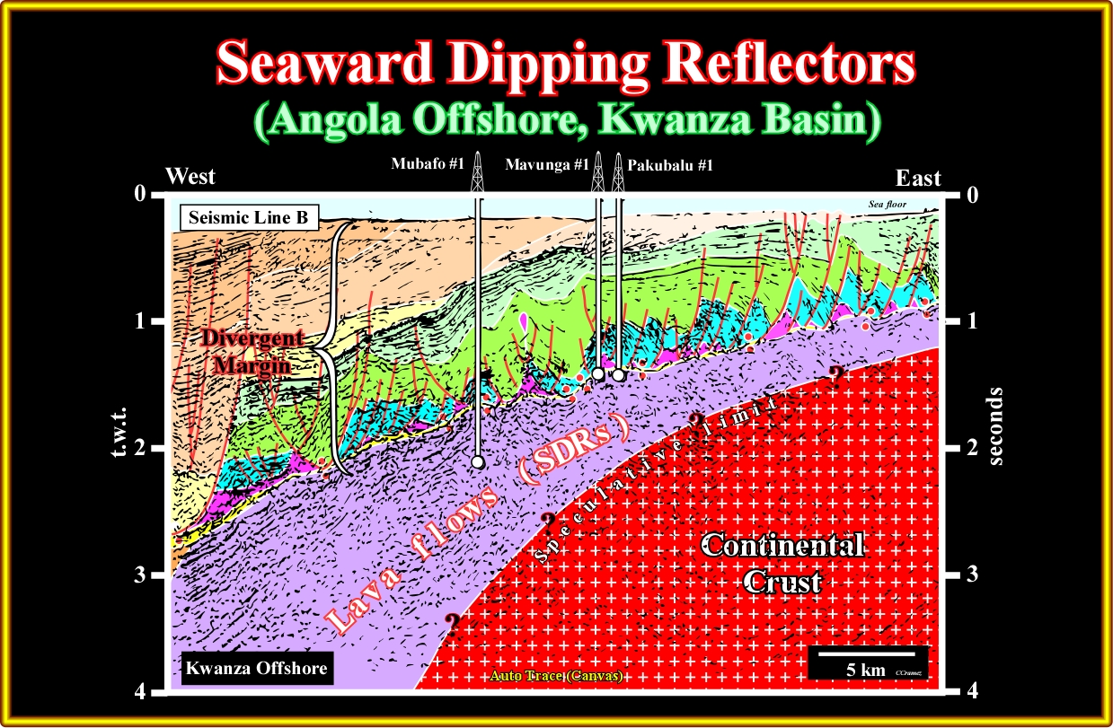
Plate A49.05- The proposed limit between the continental crust and the subaerial volcanic crust is, here, speculative. We used such a limit just to illustrate how difficult it is to map the COB. In fact, it dips seaward and increases in depth. We will assume that since the thickness of the volcanic crust is higher than 1 second, the substratum of the basin is any more the continental crust.

Plate A49.06- This random 3D line, located on the northern area of the block 19, corroborates (not verifies) the Mijuca fracture zone and a shallow continental crust northward of it. Do not forget, the difference between corroboration and verification. In science, an hypothesis can not be verified (from the Latin verus what means truth), it can only be corroborated, validated or refuted.
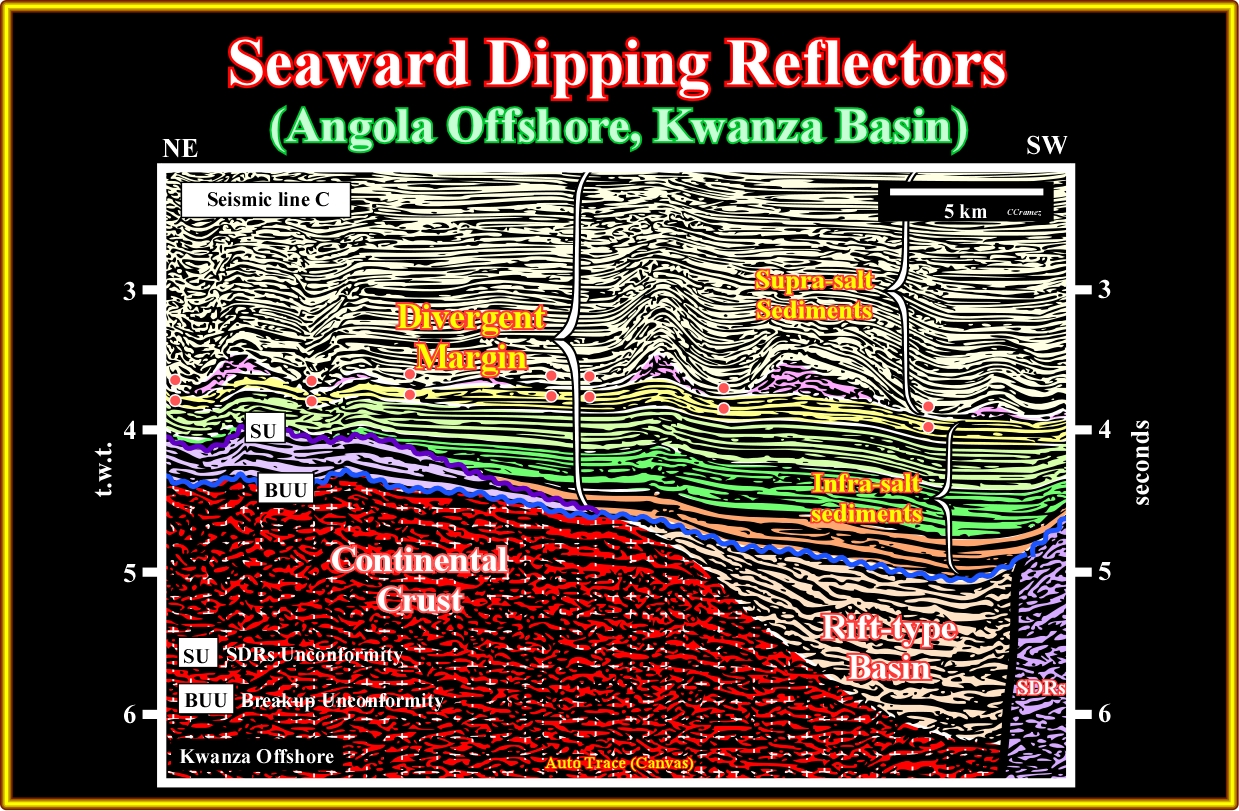
Plate A49.07- This tentative interpretation is highly suggestive, since one can recognize that the rift-type basin is limited by the breakup unconformity and the seaward dipping reflectors onlap on it. On the other hand, in the eastern lower part of the line, a major fracture zone separates the rift-type basin from the SDRs.

Plate A49.08- Seismically speaking the SDRs are not evident, however as illustrated in the tentative interpretation (next plate), the subaerial lava flows were crossed by the exploration well drilled on this seismic line. In fact the halokinesis and the lateral change in velocity intervals are enough to mask the SDRs.

Plate A49.09- Without the exploratory well's results (drilled more or less 2 kilometres northward of this line) quite few geoscientists, particularly the naive inductivistes, would advance the hypothesis of the presence of SDRs in this line, that which is obvious in the well's results as illustrated next.

Plate A49.03- The well's results (more of thousand meters of subaerial volcanics lava were drilled) and the interpretation of the seismic line, in which the well was locate(perpendicular to the previous one) clearly indicate the presence of SDRs in this area.
to continue press
next

Send E-mail to carloscramez@gmail.com with questions or comments about these notes (Altlantic-type Divergent Continental Margins).
Copyright © 2012 CCramez
Last modification:July, 2014