
The concept of model varies through an enormous spectrum of meanings. Geoscientists chose to paint a picture of the reality by building a model. They try to encode experiences of the real world and then make use of this formalism to generate predictions. Similarly, the word observation has its own spectrum of meanings, since observations range from detached observer, totally isolated from the target system to diary notes.
Observations and real world facts are the building blocks from which geoscientists construct the visions of the reality. But each of these views is merely a small slice of the reality. It is the process of putting the pieces together to form ever more accurate pictures that constitutes what in science is called a model. In every day geological parlance, observations are the memory traces left behind geoscientists's brains when outside world impresses itself upon them via their sensory channels of sight, sound, touch, etc. In fact, instead of simply describing all geological and geophysical features by simple cataloguing process, the models and simulations reveal the general mechanisms.
Seismic lines should be interpreted under the influence of a sedimentary model. Then, the model can be modified according to the tentative geological interpretations of the lines. In this way, geoscientists evolve in understanding and the seismic lines may then be reinterpreted according to a new model, and so on. Since, geological hypotheses or models have been advanced, they involved representation of physical reality by letters, words or figures. However, all these representations should not be confused with the real things. In Geology, the word sandstone or turbidite, is not itself a sandstone or a turbidite, but only an incomplete virtual reality.
Contrary to the idea that observations in geology are the facts upon which scientific hypotheses are based, it must be said that the majority of geological hypotheses were formulated a priori in order to explain problems raised by observations, that is to say, they have not been built from a collection of detailed geological observations using inductive approaches.
The most efficient method in geology as well as in other branches of science is by trial and errors. A geoscientist that does not recognize his mistakes never progress. He spend the majority of his professional carrier rediscovering the wheel and verifying hypothesis or conjectures that he advanced on the basis of naive inductive observation. In seismic interpretation, it is quite easy to recognize such geoscientists. You just need to look to the legend of their maps, where you will, probably, find a particular phraseology : (a) Yellow marker ; (b) Red marker ; (c) Yellow bodies ; (d) Mickey-mouse structures, etc. The major problem with these geoscientists is that they are afraid to make mistakes. To them, contrariwise to K. Popper, observation precedes theory. They make descriptive observations (without an a priori model) and, then, they propose their own model to explain their observations. Then and contrarily to the geoscientists following an hypothetical-deductive approach, they look mainly to the data that corroborate their model (verificationism), since their mind filtrate (forget) the data refuting the model.
Obviously, you used the hypothetical deductive approach, which is depict in the next plate.
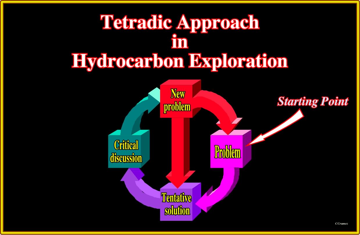
Plate 002- A tetradic schema is often used to depict the hypothetico-deductive hydrocarbon exploration approach : (i) Problem ; (ii) Tentative solution ; (iii) Critical discussion ; (iv) New problem ; (v) Tentative solution and so on. Tentative geological solutions must be falsifiable (empirical) and not metaphysical (not falsifiable). Typical examples of unfalsifiable or metaphysical geological hypothesis are : "In this sedimentary basin, the presence of source-rocks is possible or not depending on the well's results" or " Reservoir-rocks are present, but their petrophysical characteristics are questionable" or " In Atlantic-type divergent margins, the burying of the sediments can be good or bad". When an inductive / verificationist geoscientist advances that "all argillaceous rocks that are source-rocks are black", such hypothesis remains valid even when he observes red sandstones or white limestones, since all data that is not a counter-example confirms that all argillaceous rocks that are the source-rock are black. In fact, he can even easily show (extensional logic) that, all data is an example of the advanced hypothesis : 1- Everything that is a argillaceous rock that is a source-rock is black ; 2- If something is an argillaceous rock that is a source-rock, then it is black ; 3- Everything is black, except if it is not an argillaceous rock that is source rock. Therefore, everything that is not an argillaceous rock, that is a source rock, and everything, that is not black, confirms the hypothesis. His hypothesis is just not confirmed in the case of anything that is, at same time, source-rock and is not black, that is to say, in the case of a counter-example. All this shows why the inductive method, and particularly the verificationism is rejected by the majority of geoscientists working in oil business.
According to the classification of the sedimentary basins proposed by Bally & Snelson (1980), an Atlantic-type divergent margin is a sedimentary basin developed in association with the formation of new oceanic crust (not associated with the formation of the megasutures), in areas where extensional tectonic regimes are predominant, that is to say, margins with a quite reduced or absent seismic activity.
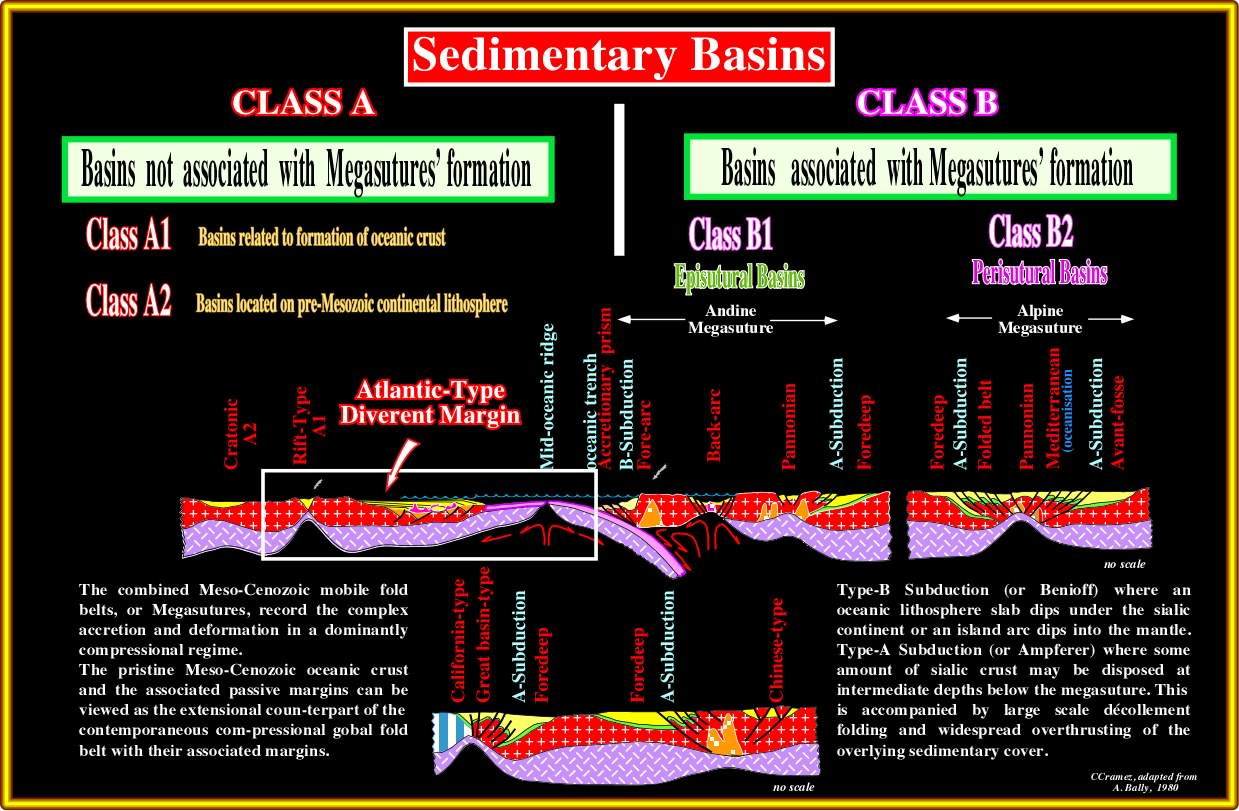
Plate 003- In the field or on seismic lines, one or several rift-type basins (generally half-grabens with a predominant landward vergence) underlie the Atlantic-type divergent margin. A major unconformity (breakup unconformity, often dubbed BUU) individualizes the rift-type basins from the overlying margin sediments. In rift-type basins a sedimentary environment trilogy (alluvial, lacustrine and fluvial) is often recognized with potential source-rocks in the lacustrine environment. In the margin, above proto-oceanic sediments (sand-shales and evaporites), a backstepping and forestepping intervals are easily recognized with a major downlap surface between them. Potential margin marine source-rocks are often associated with the interface between the transgressive and regressive phases of the post-Pangea continental encroachments cycle. In addition, potential source-rocks and good reservoirs-rocks (limestones, reefs, travertines, etc.) are also possible in the proto-oceanic sediments (lowermost part of the margin, in which non-marine and shallow marine sediments are predominant), particularly in depocenters underlying evaporitic intervals.
As illustrated below, Atlantic-type divergent margins are not limited to the Atlantic ocean. They are associated with the breakup of the Pangea supercontinent and subsequent drifting of the individualized continents. In other words, the geological model proposed by few Total's geoscientists for the opening of South Atlantic has been tested not only in South Atlantic, but in North Atlantic, Indian Ocean, Arctic Sea, Gulf of Mexico, Antarctic Ocean. The same has been done in the collision areas between Atlantic type Margins (Alps, Caucasus, Bangladesh, etc.).
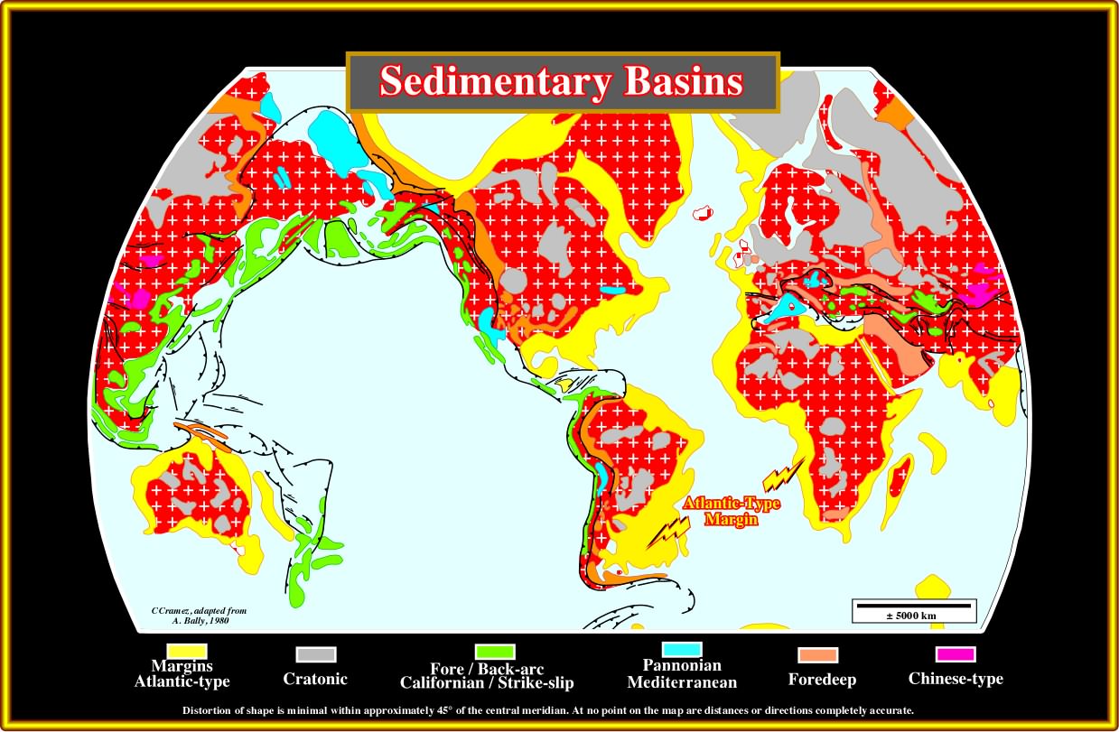
Plate 004- This plate illustrates the Bally and (1980) classification of the Ceno-Mesozoic sedimentary basins. Obviously, the Atlantic-type basins, drawn in yellow, fossilize and overlie rift-type basins developed during the lengthening (rifting) of the Pangea supercontinent. The Atlantic-type divergent margins contrast with the divergent margins developed during the oceanization of the episutural basins (Pannonian, Mediterranean-type, etc.), which are associated with the formation of the Ceno-Mesozoic Megasuture (located inside of the megasuture, while the perisutural basins are located at their edges), that is to say, developed in areas where compressional (shortening) tectonic regimes are predominant and the seismic activity important).
to continue press
next

Send E-mail to carloscramez@gmail.com with questions or comments about these notes (Altlantic-type Divergent Continental Margins).
Copyright © 2012 CCramez
Last modification:July, 2014