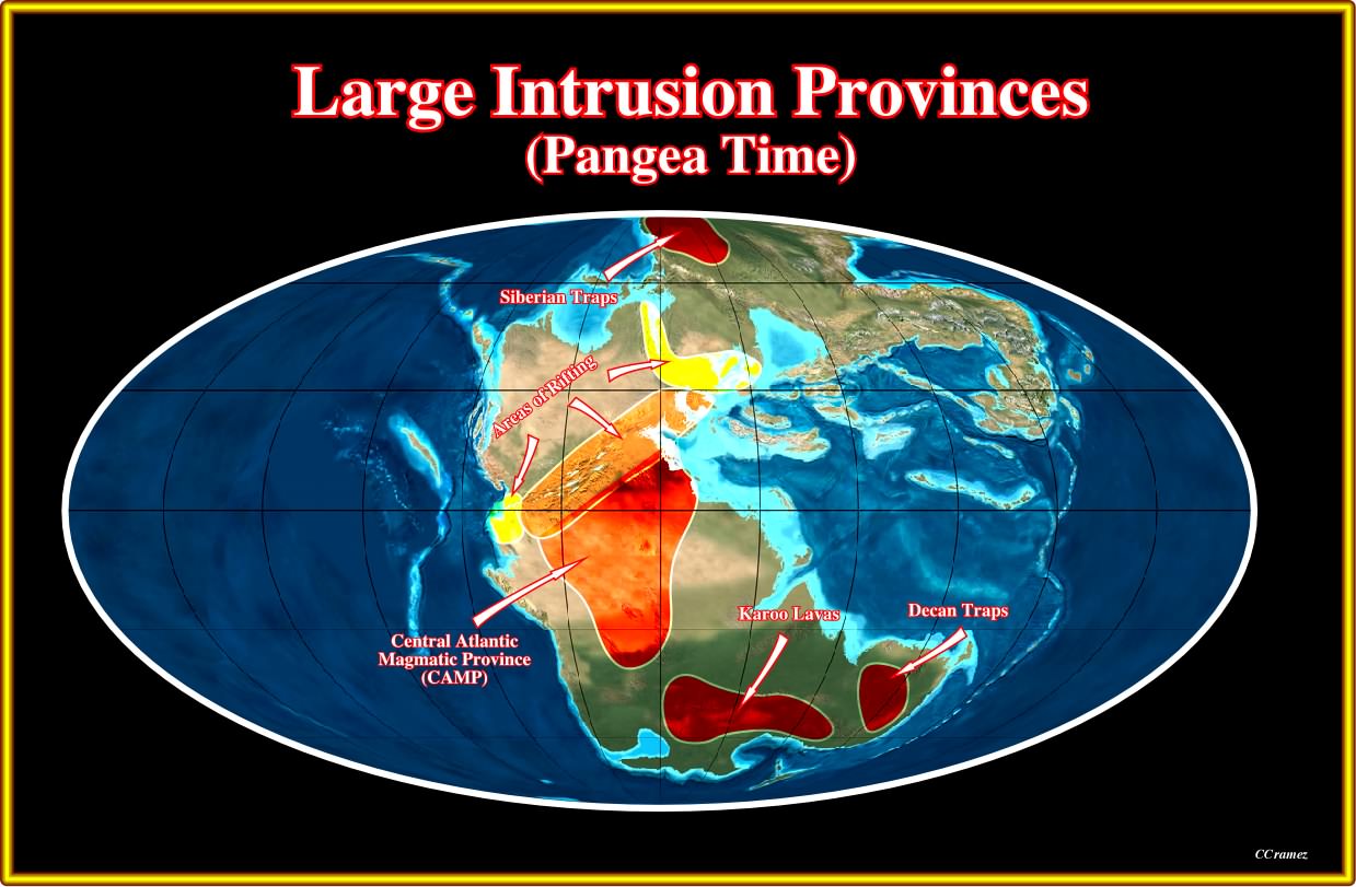
Plate 024- Four major Large Intrusion Provinces (LIPs) were recognized during the Pangea supercontinent : (i) Siberia Traps ; (ii) Central Atlantic Magmatic Province, which is better known by its shortened form CAMP ; (iii) Karoo lavas and Deccan Traps. These provinces, certainly precursors of rifting and breakup of the Pangea lithosphere, provide the geological conditions required to develop volcanic divergent margin.
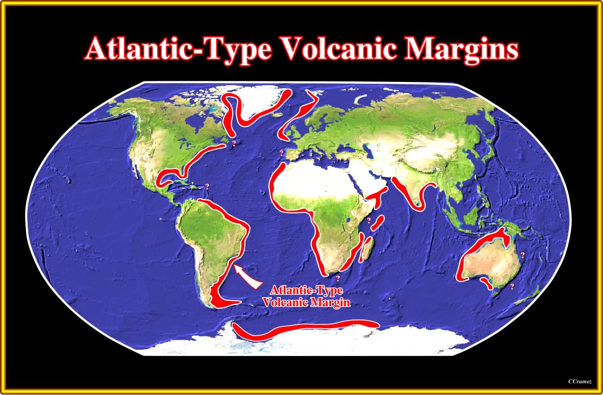
Plate 025- As illustrated, the Atlantic-type volcanic margins are known all along of the Pangea's breakup zones. The West Iberia margin and its Canadian conjugate are, probably, exceptions. As said previously such margins are quite particular and probably can not be considered anymore as Atlantic-type (Bally's sense), particularly the Galicia offshore. In the areas where the margin develops, more or less, parallel to major fracture zones (e.g. Gulf of Guinea, Pernambuco offshore, etc.), the SDRs area present (see later). Their recognition requires a good knowledge of the tectonics of the area. In the East Australia, we do not have seismic lines enough and particularly regional lines to decide if the margin is volcanic or not.
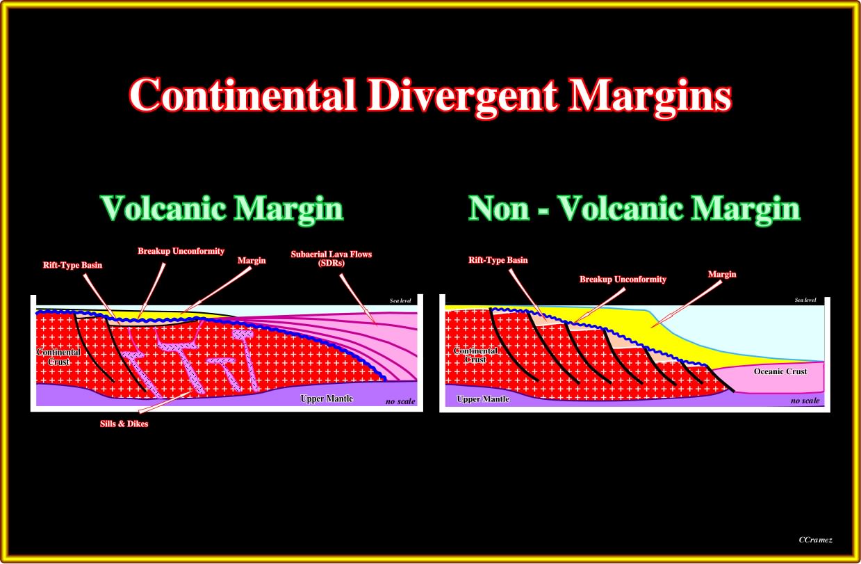
Plate 026- Be that as it may, geoscientist build up two geological models to explained the divergent margins' observations : (i) Volcanic margins and Non-Volcanic margins. In the volcanic margins the COB (Continental Oceanic Boundary) is not abrupt as in the non-volcanic margin, since an intermediate subaerial crust (SDRs) is developed between the continental and oceanic crust. Such intermediate subaerial crust does not exits in a non-volcanic margin. On the other hand, in a volcanic margin, the thinning and lengthening of the lithosphere is not so accentuated as in a non-volcanic margin. Finally, one can say that in volcanic margins, the rift-type basins are in filled by non-marine and/or shallow marine sediments, while in non-volcanic margins (Galicia and Flemish Cap), they are, often, starved with deepwater sediments.
The next seismic lines (uninterpreted and tentatively interpreted, in geological terms) can have been used to test, that is to say, to refute to Total's hypothesis for Atlantic-type divergent margins associated with the breakup of the Pangea supercontinent. Put differently, if you disagree with a proposed tentative geological interpretation, as a geoscientist, you are scientifically obliged to propose another tentative interpretation trying to refute it and send it for discussion (carloscramez@ gmail.com) in order to make progress (petroleum exploration progress by trial and errors and not by no falsifiable interpretations). However, don't forget that "The knowledge that we get from our senses, and foolishly believe in, is inevitable observer-relative" (Heraclitus, circa 500 B.C.)
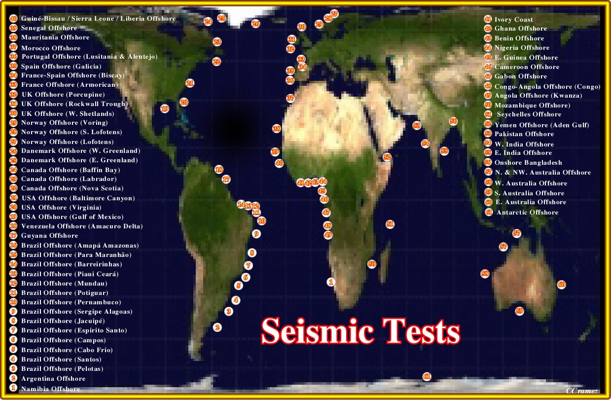
Plate 026- In this Gall-Peter projection accurate area map (it shows the true, i.e., smaller size of North America, Greenland, Europe, and Russia, etc., and the true larger size of Africa, South America, and Australia, etc,) is roughly indicated the location of the seismic lines used to test the volcanic or no-volcanic nature of the Atlantic-type divergent margins.
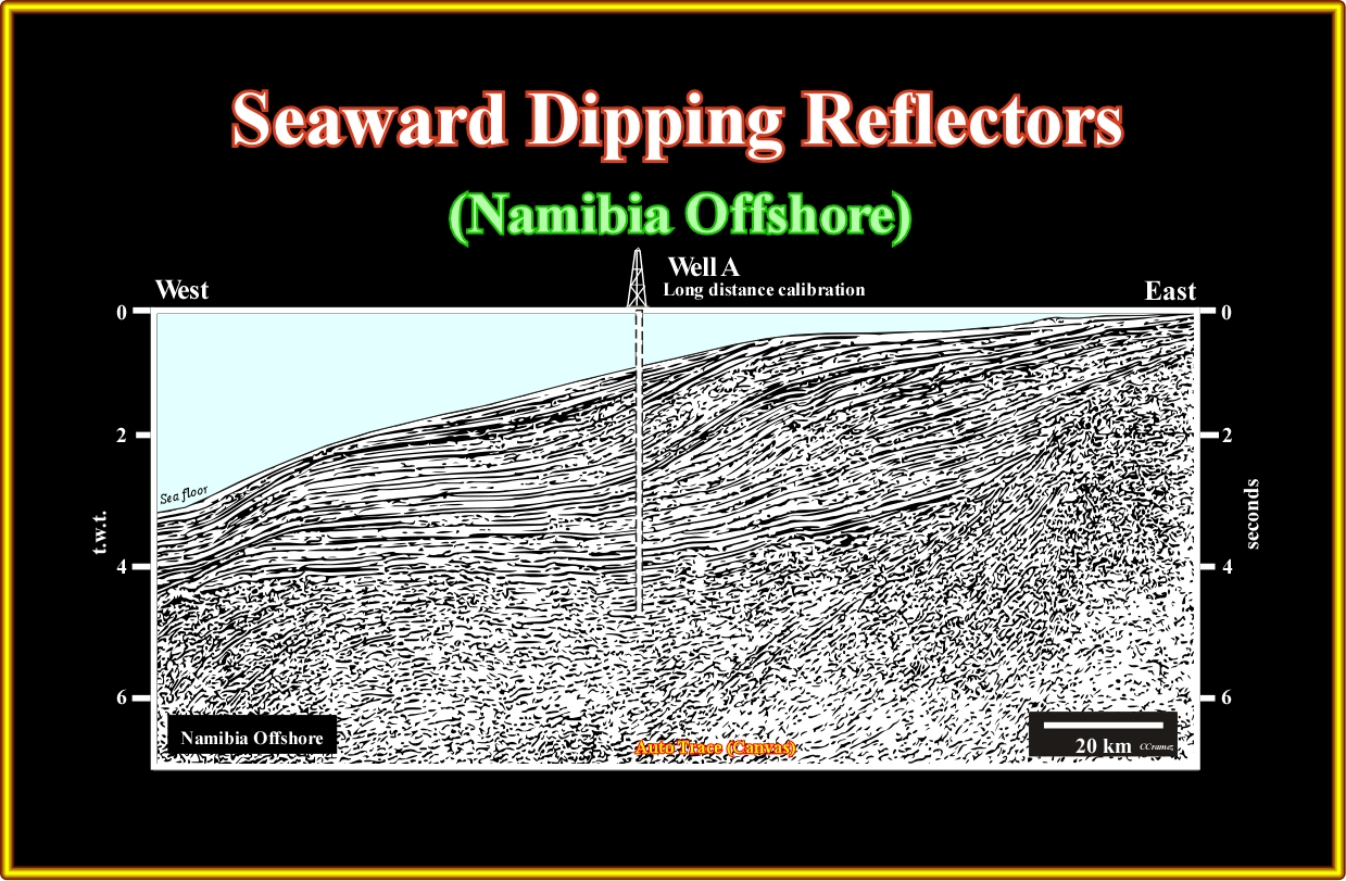
Plate A1.01- On this seismic line, it is easy to recognize the basement (probably a Precambrian or Paleozoic fold-belt) in the lower eastern part and quite nice seaward dipping reflectors in the central and lower western part. Above the basement and SDRs a post-Pangea sedimentary prism can be subdivided in a lower retogradational (transgressive) and an upper progradational (regressive) interval. An exploration well drilled not far from this seismic line allows a long distance geological calibration.
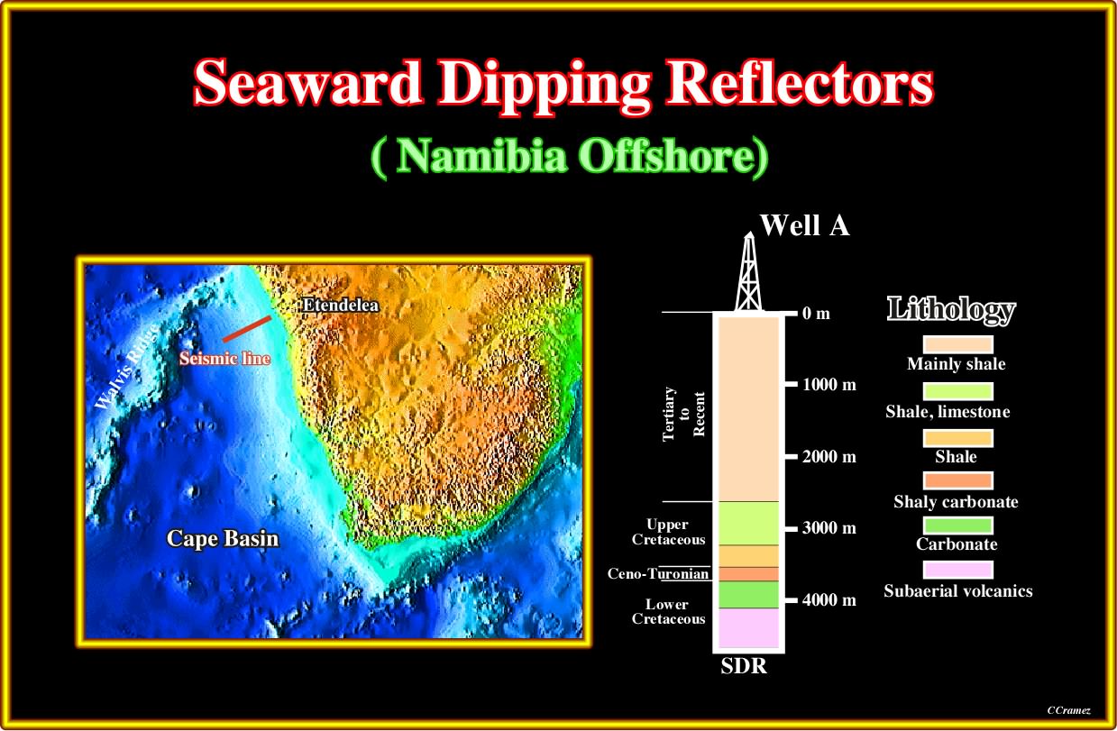
Plate A1.02- The geological results of the exploration well drilled not far from the previous seismic line are here summarized. On the subject discussed in these notes, it is interested to notice that the well drilled around 500 meters of SDRs, that is to say, subaerial lava flows, which before drilling were considered by a lot of geoscientists as reflectors induced by rift type basin sediments with generating petroleum potential (source-rocks).
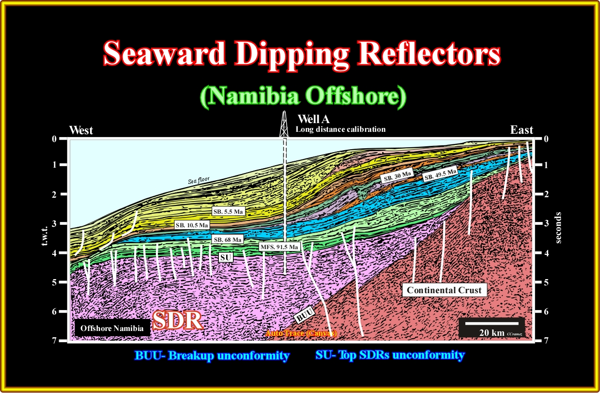
Plate A1.03- In the 90’s, in this area, several major oil companies drilled exploration wells looking for hydrocarbons generated by potential lacustrine source rocks deposited in rift-type basins developed in the continental crust. In fact, the reflectors in the lower western part of this line, which are tilted and looking seaward, were interpreted as induced by sedimentary interfaces within Lower Cretaceous Rift-type basins. Even before drilling, several geoscientists tentatively interpreted such reflectors as lava flows and strongly suggest their management to give up or not participate in the Namibia offshore's exploration. The results of all wells drilled in the area corroborate the subaerial lava flows interpretation proposed few geoscientists.
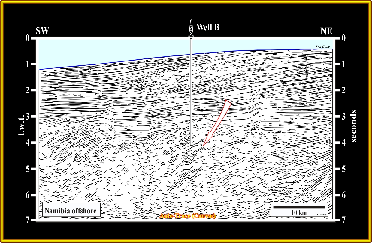
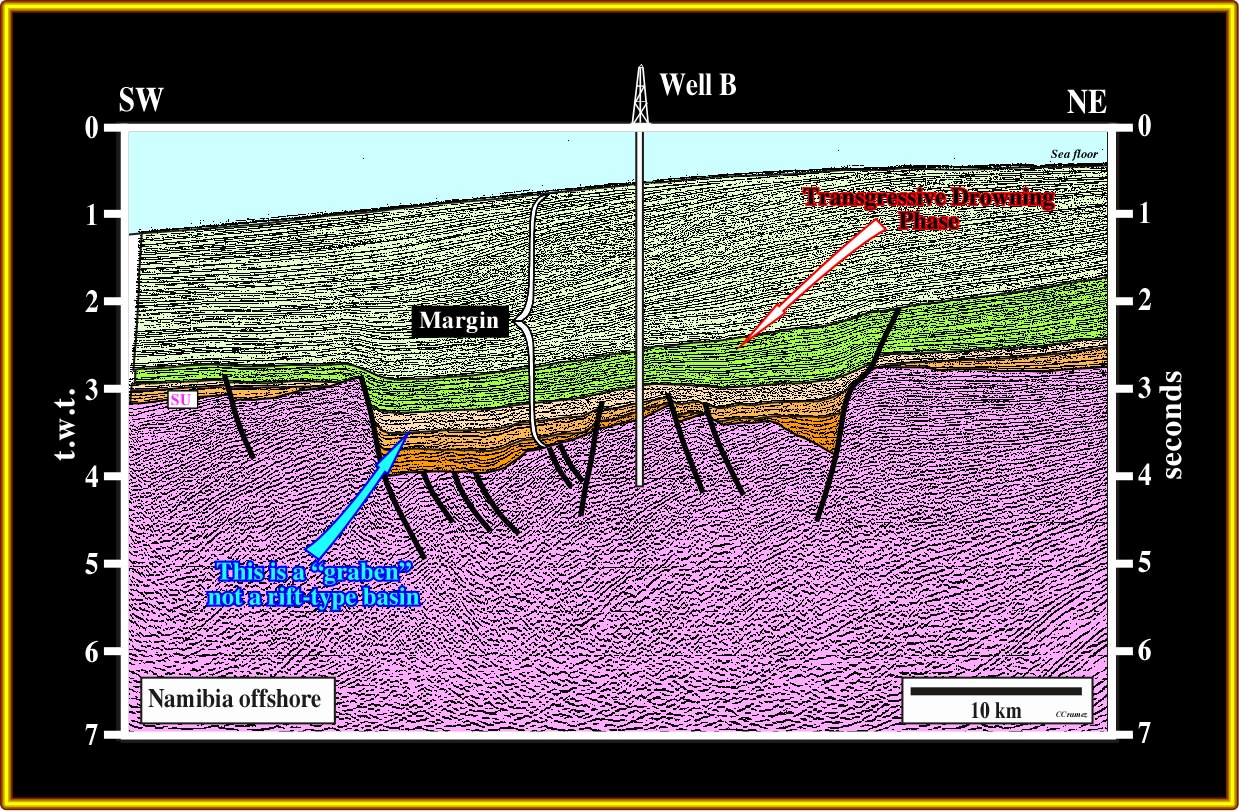
Plate A1.04- On this seismic line, the seaward tilting of the subaerial lava flows create a half-grabens with opposite vergence that should not be taken as rift-type basins. In fact, the rift-type basins are induced by a predating regional lengthening of the lithosphere and not by local lengthening creating the sinking of the expansion centres. As we will se later, the presence of this kind of graben is well documented in other volcanic margins. An exploration well was located and drilled on this seismic line.
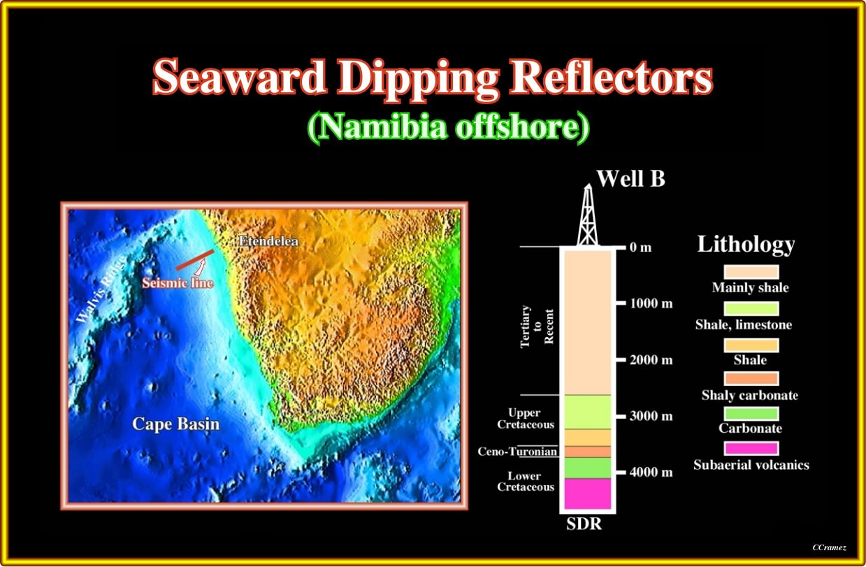
Plate A1.05- The results of the exploratory well drilled on the previous line corroborate the presence of subaerial lava flows as the infrastructure of the margin. In fact. the well recognized more than 300 meters of volcanic material.
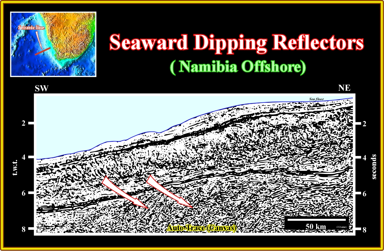
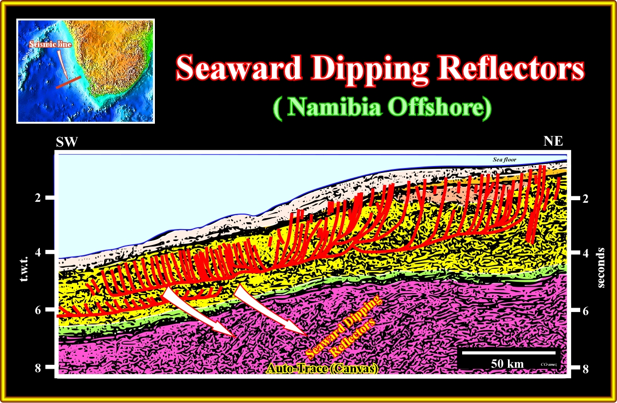
Plate A1.06- On this line the SDRs are quite obvious. The seaward gliding of the margin sediments created a local compressional tectonic regime with the development of real listric faults, as suggested on the tentative interpretation illustrated next. It is interesting to notice that the regional lengthening of the Pangea lithosphere ended with the breakup. The emplacement of the subaerial lava flows (expression a little bit redundant since lava flows material can just develop outside water; under water the volcanic material froze) postdate the breakup enlarging the early margin. When the spreading centres sinking and become covered completely with water the extruded volcanic material froze forming the oceanic crust. The oceanic crust is the mainly responsible of the oceanization and enlargement of the margin.
![]()
Plate A1.07- As suggest in this plate the transition from SDRs (subaerial axis, high extrusion rate and large outflow lengths) to oceanic crust (normal axis depth and extrusion rate, small flow lengths, often pillow-lava) is a consequence of the sinking and immersion of the spreading centres due to the loading of the successive lava flows. The subhorizontal geometry of the SDRs over the feeder dykes explain why the magnetic anomalies are subdued, which is not the case in the oceanic crust (quite small or inexistent flow). On the seismic lines, SDRs give more or less continuous and dipping seaward reflections, while the reflections associated with the oceanic crust are hummocky or mounded geometry.
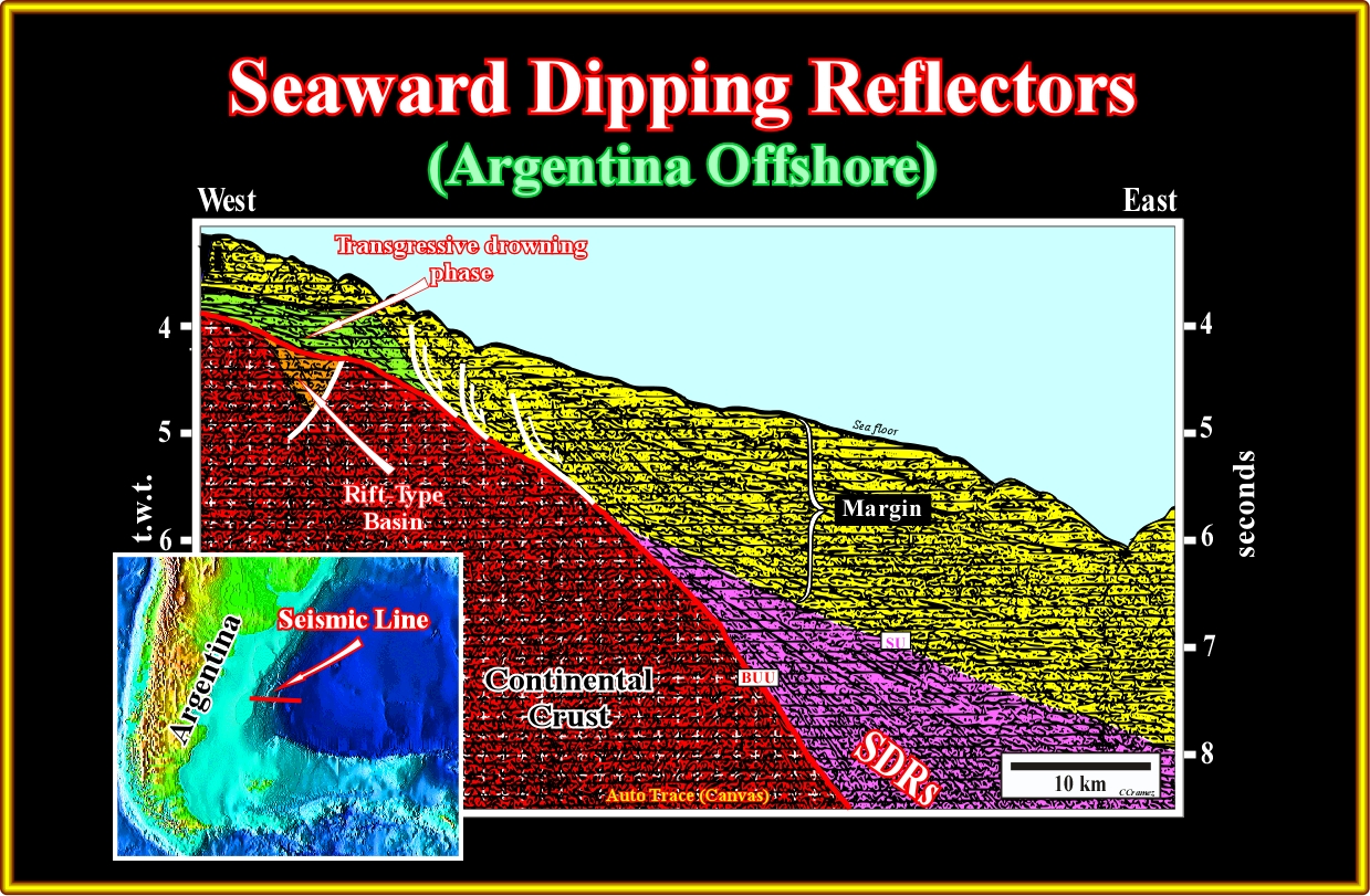
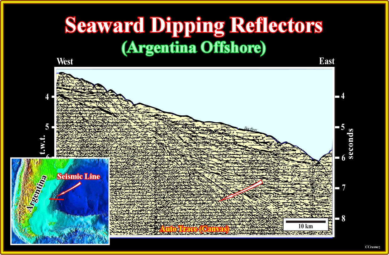
Plate A2.01- This seismic line from Argentina offshore illustrates clearly the difference between rift-type basins, which predate the breakup of the lithosphere and SDRs, which postdate the breakup). In fact a small rift-type basin is recognized in the western part of the line, while SDRs are obvious in the eastern part. It is not clear if SDRs cover the rift-type basin (the thickness of the volcanic material covering the rift-type basin can be under seismic resolution. Contrariwise to the geoscientists who proposed exploration wells in the Namibia offshore, the argentine geoscientists taking into account the K. Hinz’s works, considered this offshore as very poor, in terms of hydrocarbon potential. In addition, as depicted on this line, the thickness of the margin sediments is to small to develop a generating petroleum sub-system. In this tentative interpretation of the previous line there are not lava flows over the small rift-type basin developed in the continental crust during the lengthening of the Pangea (Gondwana supercontinent) before the breakup of the lithosphere. The unconformity underlying the breakup (BUU) lies at the base of the SDRs, near the axis of rupture and at the top of the Pangea continental crust (rift-type basins appertain to this crust) far from the axis, where the continental crust is not covered by volcanic material. It is important to notice that the thickness of Pangea continental crust is quite important even near the axis of the rupture. In fact according different geoscientists since the thickness of the continental crust reaches 10-15 km, it cannot anymore be lengthening by normal faults; it is stretched and injected by volcanic material. Subsequently, if such a conjecture is true, just the more proximal rift-type basins (in relation to the associated underlying mantle plume) can, eventually, be covered by lava flows.
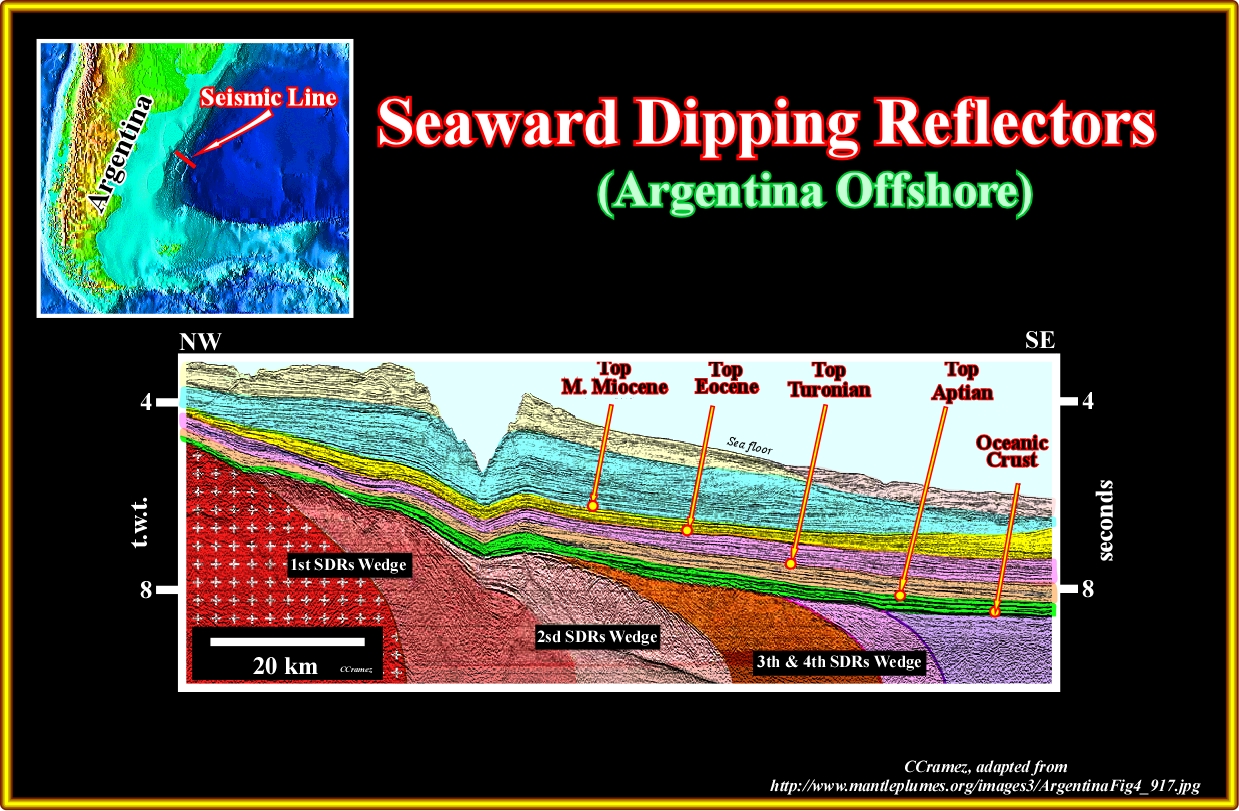
Plate A2. 02- Different generation of SDRs can, often, be recognized on seismic lines as it the case on this seismic line. Distinct disconformities with a low-frequency seismic pattern, separate the SDR wedges, which seem to be the expression of an apparently general trend in the breadth and thickness of the SDR sequences. In this area, the largest volumes of volcanics are systematically emplaced along the southern edges of the margin segments, just north of the transfer zones. The breadth and thickness of the SDRs decrease towards the north up to the next transfer zone. The transition from SDRs to oceanic crust is subtle. The oceanic crust is probably at the end of the line (SE). The margin is quite starved. Just the overbank sediments associated with the Amaghino canyon have a significant thickness.
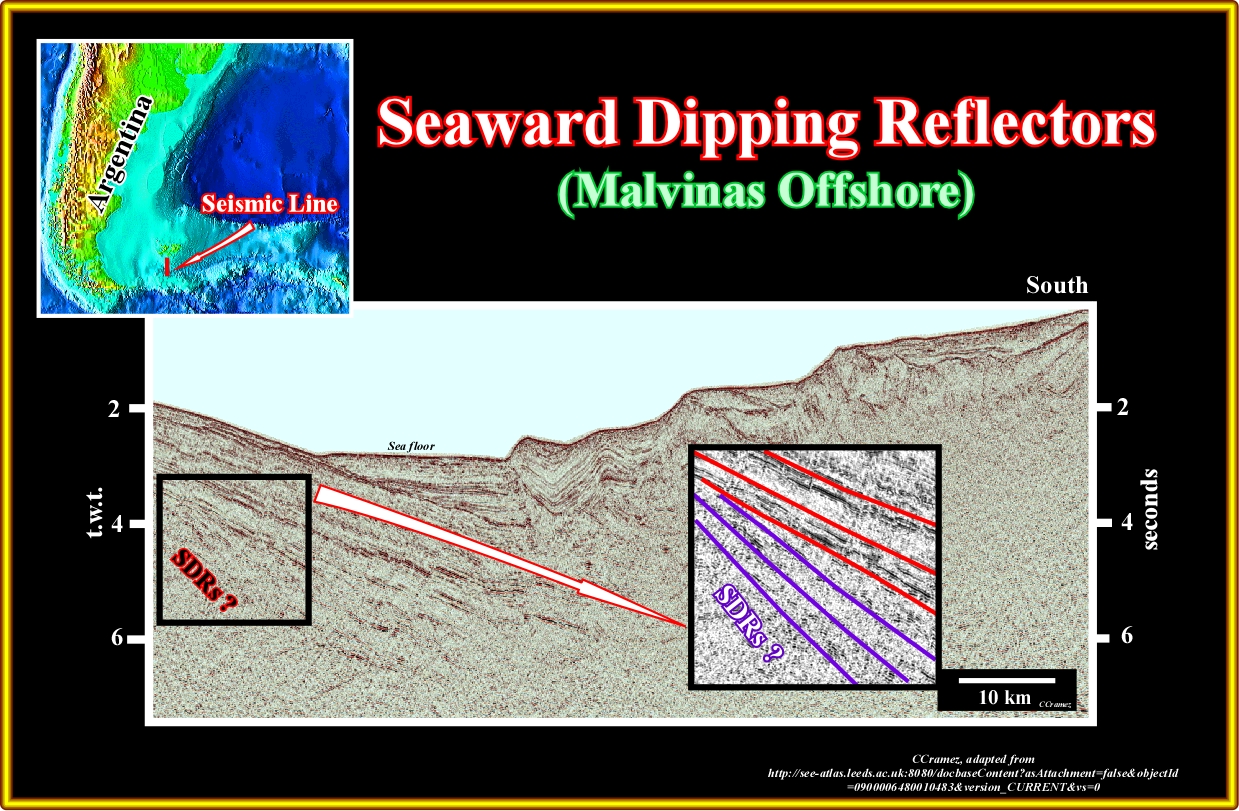
Plate A2.03- On this N-S seismic line (strike line in relation to the COB), southward dipping reflectors recognized at the bottom of the margin northward of the A-subduction zone (south of the Malvinas) are probably seaward dipping reflectors (SDRs), that is to say, subaerial lava flows. Such a conjecture seems seems to be corroborated by the seismic lines shot in north Malvinas offshore, as illustrated in the next plate.
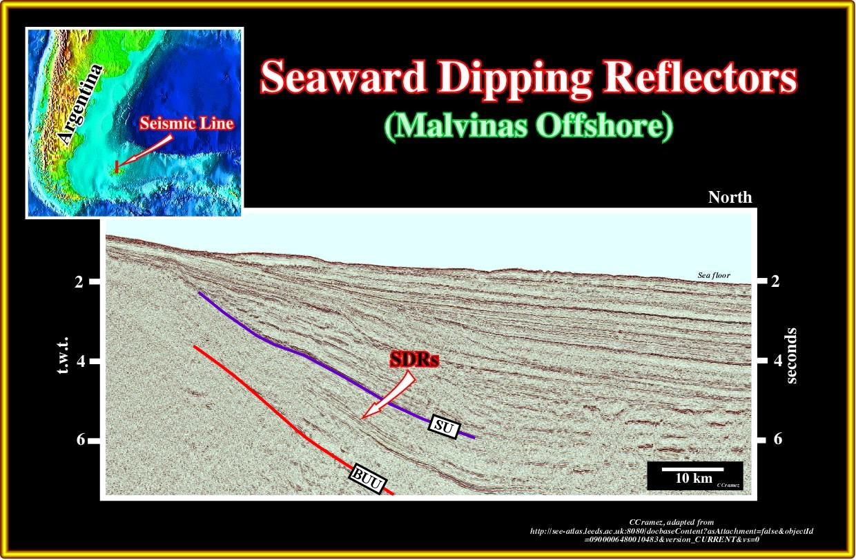
Plate A2.04- Tentatively, in the southern area of this line, from the bottom to top, one can recognize the breakup unconformity (top of the Pangea continental, BUU), a SDRs interval a, the SU unconformity (at the top of the SDRs) and the margin sediments with a middle interval strongly prograding northward. Obviously, these SDRs are not typically, but one must take into account that the North-South orientation of these seismic lines does favour their recognition.
to continue press
next

Send E-mail to carloscramez@gmail.com with questions or comments about these notes (Altlantic-type Divergent Continental Margins).
Copyright © 2012 CCramez
Last modification:July, 2014