
Universidade Fernando Pessoa
Porto, Portugal
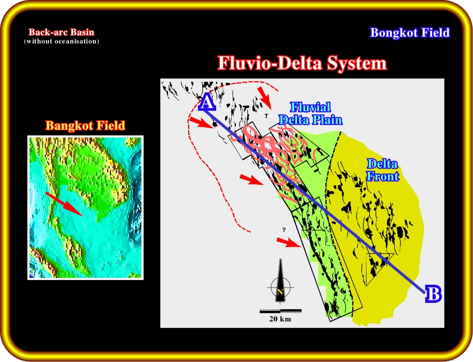
Plate 18- In a context of back-arc basin without oceanisation, the Bongkot field, in the Gulf of Thailand, shows that the depositional systems records two major geologic events: (i) The absence of breakup of the lithosphere, which gives low subsidence and accommodation rates, (ii) The compressional tectonic regime oblique to the pre-existent normal faults bounding the half-grabens. This tectonic regime reactivates the pre-existing faults creating en-échellon fold in the sediments of the sag phase.
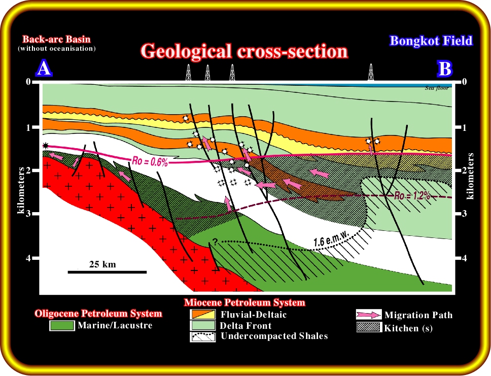
Plate 19- The Oligocene lacustrine source rocks of the rift phase can only be active where the sag deposits are thin, as is the case of the discoveries in the northern part of the Gulf. The principal generating petroleum subsystem is associated with the coals and the organic shales of the sag phase. The effective kitchen is 0.6 Ro of maturity and 1.6 e.m.w reservoir pressure. Migration is mainly lateral with a minor vertical component along faults. This generating subsystem is mostly gas prone with minor oil generation.
Plate 20- Reservoirs consist of deltaic distributary channels and mouth bars. Traps are mostly morphologic by juxtaposition developed along the fault trends The hydrocarbon accumulation consist of numerous stacked individual reservoirs (up to 70 meters per pannel). Individual oil columns are small (30 m), depending on the vertical fault displacement. In such a dispersed oil-habitat, with small accumulations and small oil columns, exploration success demands appropriated techniques and geologic imagination. As Bally said, “oil may well be found in the minds of explorers, but you also like to be able to map what is the explorers' mind. The issue : mappability, i.e. seismic, as we will see in next plates.
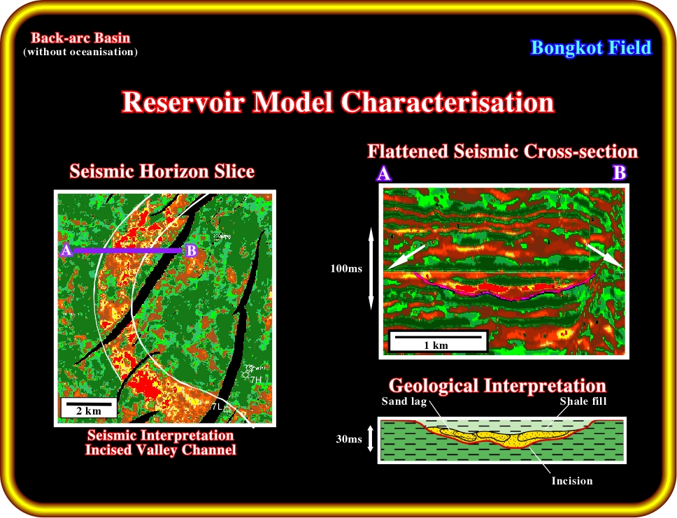
Plate 21- 3D seismic data with appropriated processing, interpreters with geological knowledge can easily recognize in Bongkot field the potential reservoirs which are mainly: a) Incised valleys and b) Laterally accreted points bars as depicted in the next plate.
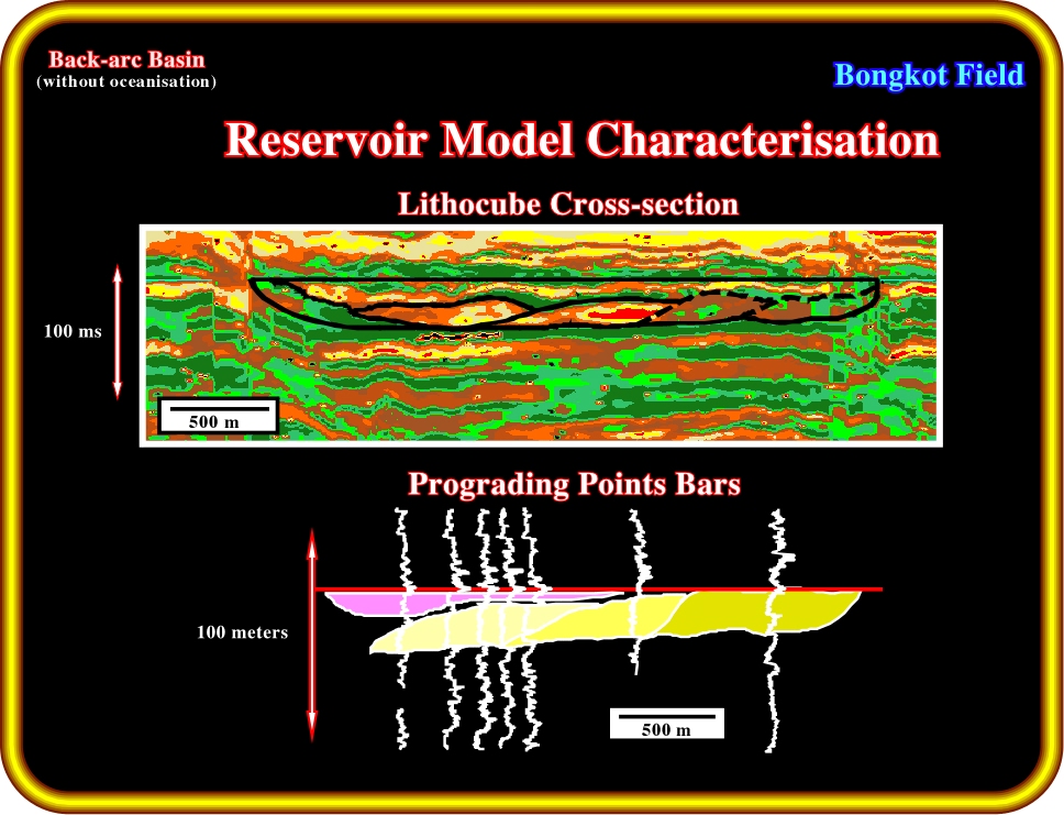
Plate 22- The lateral accretion of the points bars is well corroborated by the seismic lines and log correlation.
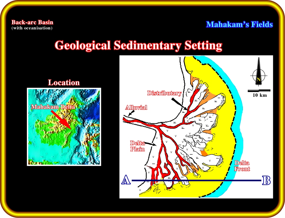
Plate 23- The Mahakam is in a geological context of back-arc basins with oceanisation. The geodynamic setting at the end of the sag phase will controls the tectono-stratigraphic evolution the margin: (i) The oceanic-floor spreading increases the accommodation and induces large sedimentary rates of up to 500 m/My. This process created a huge sedimentary prism with the classic environmental zones. (ii) The compressional tectonic regime reactivated the deep pre-existent structures and it created syn-sedimentary trend of folds striking perpendicular to the direction of the terrigenous supply.
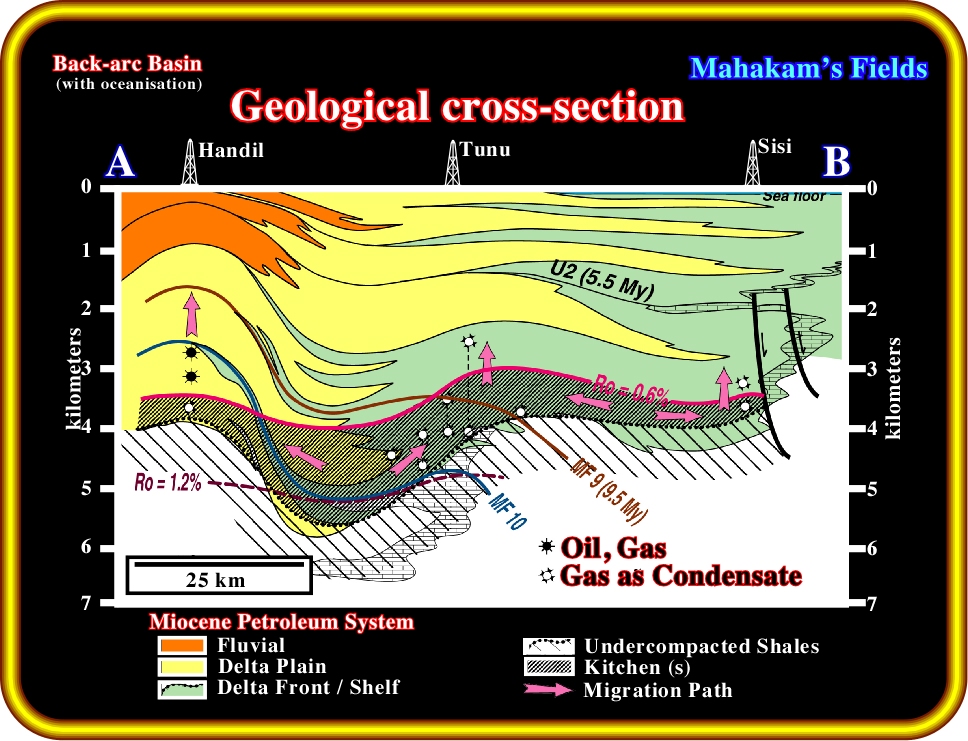
Plate 24- The present petroleum system is associated with the margin: a) The generation subsystem is provided by oil prone humic source rocks, coal beds and organic shales, as well as delta-front gas-prone shales. b) The active kitchen is between 0,6% Ro and 1.6 e. m. w. reservoir pressure. Migration is mainly lateral along carrier beds from the kitchen located in Tunu Syncline.
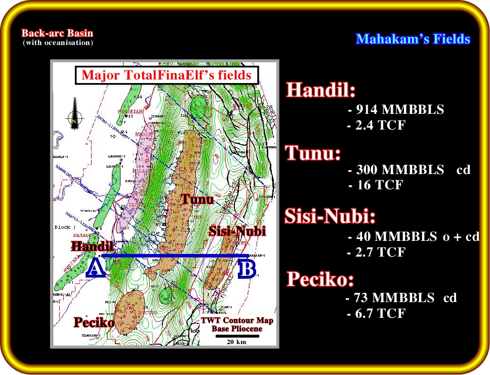
Plate 25- Reservoirs consist of distributary channel, mouth bar and tidal bar sandstones. They are distributed over several thousand meters. The traps are mainly structural.
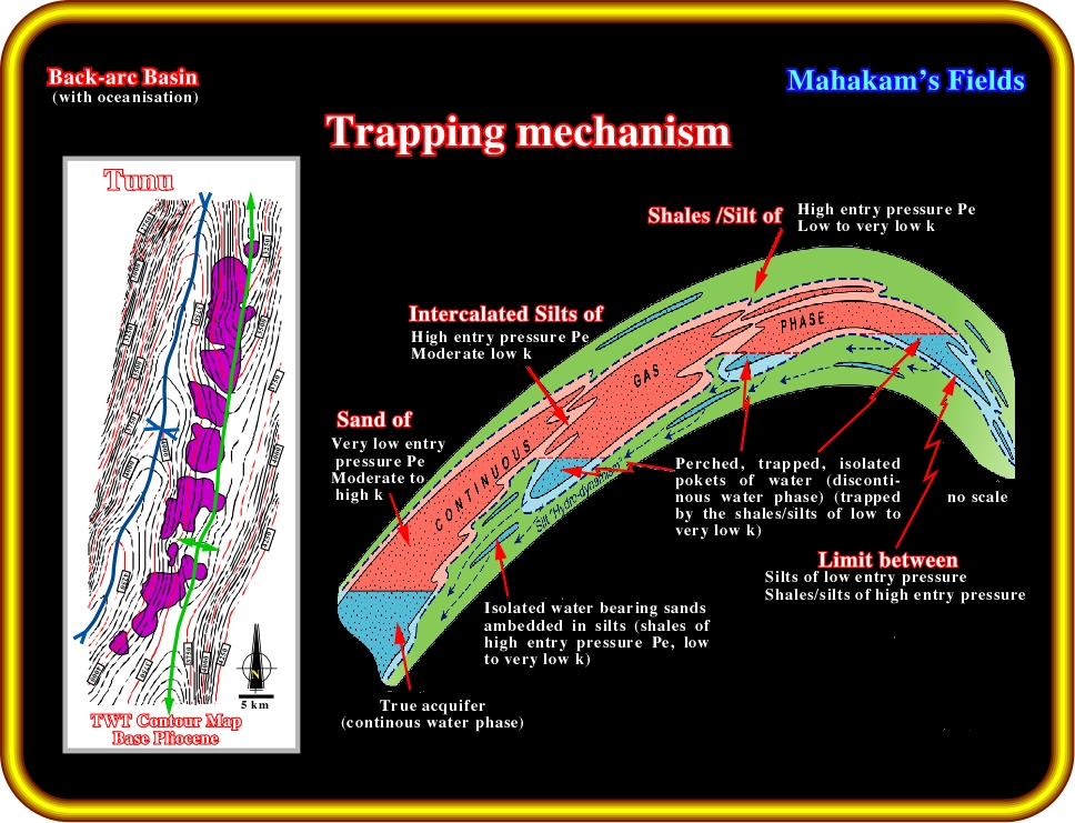
Plate 26- The traps are mainly structural. However, the stratigraphic and the hydrodynamic components of trapping enhance accumulations on west flanks of the anticlines, as illustrated on Tunu field. The presence of all trapping components, i.e. structural, stratigraphic and hydrodynamic is the key of the major accumulations such as: Handil: around 1 billion barrels recoverable and 2.4 TCF, Tunu: 300 MMBBLs of condensate and 16 TCF, Sisi-Nubi: 40 MMBBLS of oil and condensate and 2.7 TCF, Peciko: 73 MMBBLS of condensate and 6.7 TCF.
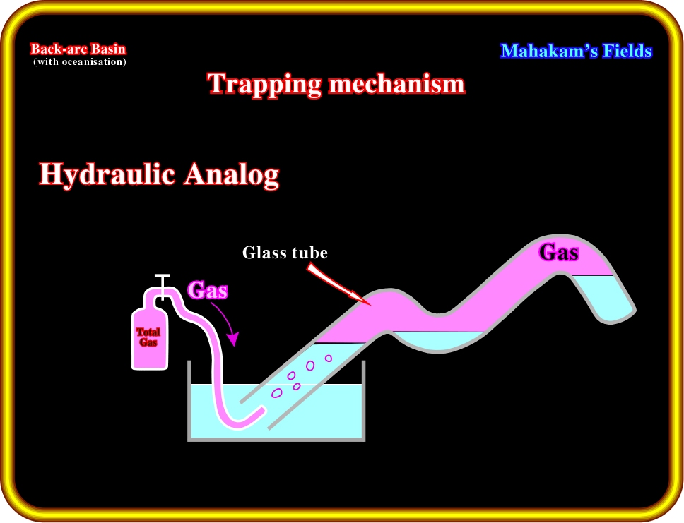
Plate 27- The trapping mechanism, particularly in the Tunu field emphasizes a downward hydrodynamic flux which strongly enhanced the trapping and the lateral displacement of the accumulation towards the west flank. The hydraulic analog here illustrated dispense all comments, however it can be push further with a little bit of imagination.
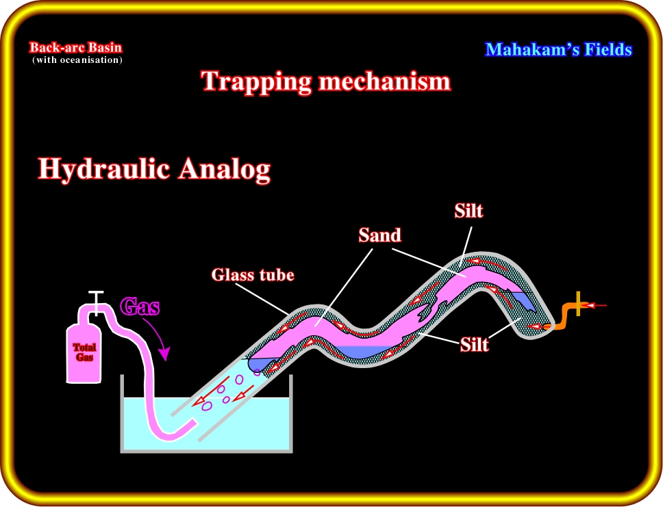
Plate 28- The trapping mechanism is enhanced by a downward hydrodynamism through the silts bounding the potential reservoirs which, in addition, pinchout eastwards.
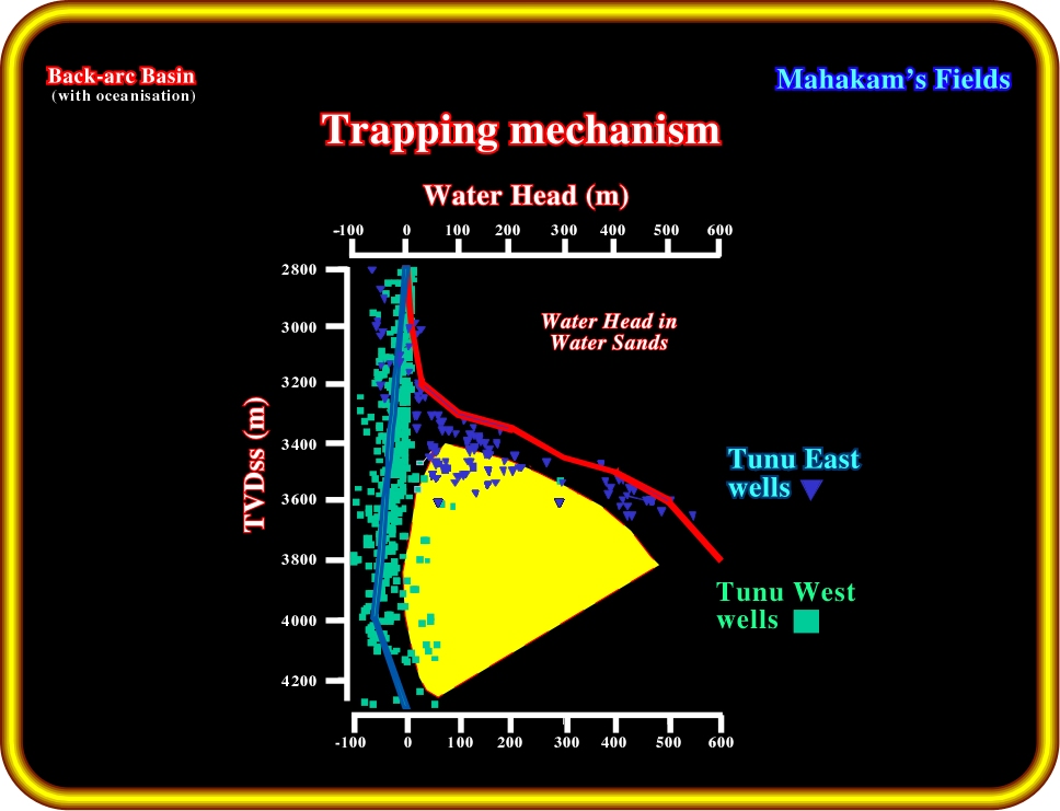
Plate 29- The observed data and particularly the water head measurements corroborate such an hypothesis. In fact, the wells drilled at the top of the structure or on the eastern flanks hit high pressure reservoirs, water filled and connected with thick gas column downdip. This plate shows between the red and blur lines the variation of the gas column with depth.
In conclusion: Global tectonics and basin classification at various stages of oil exploration have been widely used in the past and remain an efficient exploration tool to initiate major exploration decision at world scale. Used in conjunction with more recent technology will certainly help exploration in its period of maturation.
Thank you Bert for your considerable input to exploration and thanks to all of you for your attention.
![]()
Send E-mail to carloscramez@gmail.com with questions or comments about this conference.
Copyright © 2000 CCramez
Last modification:
August, 2014