Role of salt tectonics in the petroleum systems
of Angola and the Gulf of Mexico
J. M. Fonck*, C. Cramez*, and M. P. A. Jackson**
(*) Total SA, 24 Cours Michelet, La Défense 10,
92069 Paris La Défense, France.
e-mail:jean-michel.fonck@total.com
(**) Bureau of Economic Geology, The University of Texas at Austin,
Austin, Texas 78713, USA.
e-mail:jacksonm@begv.beg.utexas.edu
Presalt tectonics
Both continental margins developed on orogenic Pre-Pangaea terranes. The Kwanza and Congo Basins overly Proterozoic orogens comprising the Late Proterozoic West Congolian and Kaoko fold belts. The Gulf of Mexico overlies the Appalachian belt, which was deformed during the Ordovician Period. The basement in both continental margins was subsequently uplifted and thinned by extension over the same mantle plume until the continental crust separated. That induced sea-floor spreading and the formation of opposing divergent continental margins.The ocean adjoining the Angolan margin continues to open, so a linear margin adjoins ocean crust more than 5000 km wide. In contrast, the almost circular Gulf of Mexico ceased opening in the Early Cretaceous, so oceanic crust in the Gulf is less than 400 km wide.
Evaporites
Each conjugate margin contains a major evaporitic unit and several minor ones. In Angola, the Loeme Salt and equivalents are of Aptian age. In the Gulf of Mexico, the Louann Salt and equivalents is Callovian. The twin salt basins formed on each side of ruptured rift basins after sea-floor spreading began in the South Atlantic and the Gulf of Mexico. Each conjugate salt basin evolved separately from its twin.The salt pinched out seaward on oceanic crust and landward on the marginal sediments overlying the breakup unconformity. Evidence for this proposed relationship, which differs from the prevailing consensus, is explored more fully in papers by Marton and Buffler (1994) in the Gulf of Mexico and by Fonck et al. (1998) and Jackson et al. (1998) in the South Atlantic. Both evaporites formed autochthonous and allochthonous salt bodies. The original thickness of the salt had a major influence on the salt tectonics which controls the deformation of the basin of a whole and hence affects, as we have shown, all parts of the whole petroleum system. We estimate original thicknesses of less than 1 km in Angola and up to between 4 and 6 km in the Gulf of Mexico.
Structural Style of Salt Tectonics
In both continental margins, the proportion of preserved allochthonous salt increases basinward at the expense of autochthonous salt. Furthermore, offshore seismic lines suggest that the salt is much thicker in the distal part of the basins than in proximal areas. There are three reasons possible for this. First, salt would have flowed seaward over a dipping substratum owing to gravity. Second, salt would be expelled seaward by the weight of the wedge of overlying prograding sediments. Third, salt would be thinned by updip extension, but thickened by downdip compression. This compression can be just caused by a buttress against a structural high, such as a horst, igneous body and so forth or against a pinch-out of salt, as in the abyssal Lower Congo (Cabinda) and Perdido and Mississippi Canyon (Gulf of Mexico) fold belts.
One school of thought explains the salt tectonics in offshore Angola without extension, merely involving vertical adjustments in salt thickness. Salt tectonics is probably a combination of vertical flow and lateral tectonics. However, in the Angolan and Gulf of Mexico continental margins, we favor a strong role for extension for the following reasons. (1) Divergent continental margins are largely under gravity-induced stress regimes in which updip thin-skinned extension and downdip shortening dominate. (2) The deep-water fold-and-thrust belts require extension farther updip. (3) Mechanical modeling overwhelmingly favors considerable extension to form raft structures. (4) Our structural reconstructions look more plausible with extension; for example, without extension, sudden dissolution after a long period of stability must be invoked for some sections.
Breakup Unconformity
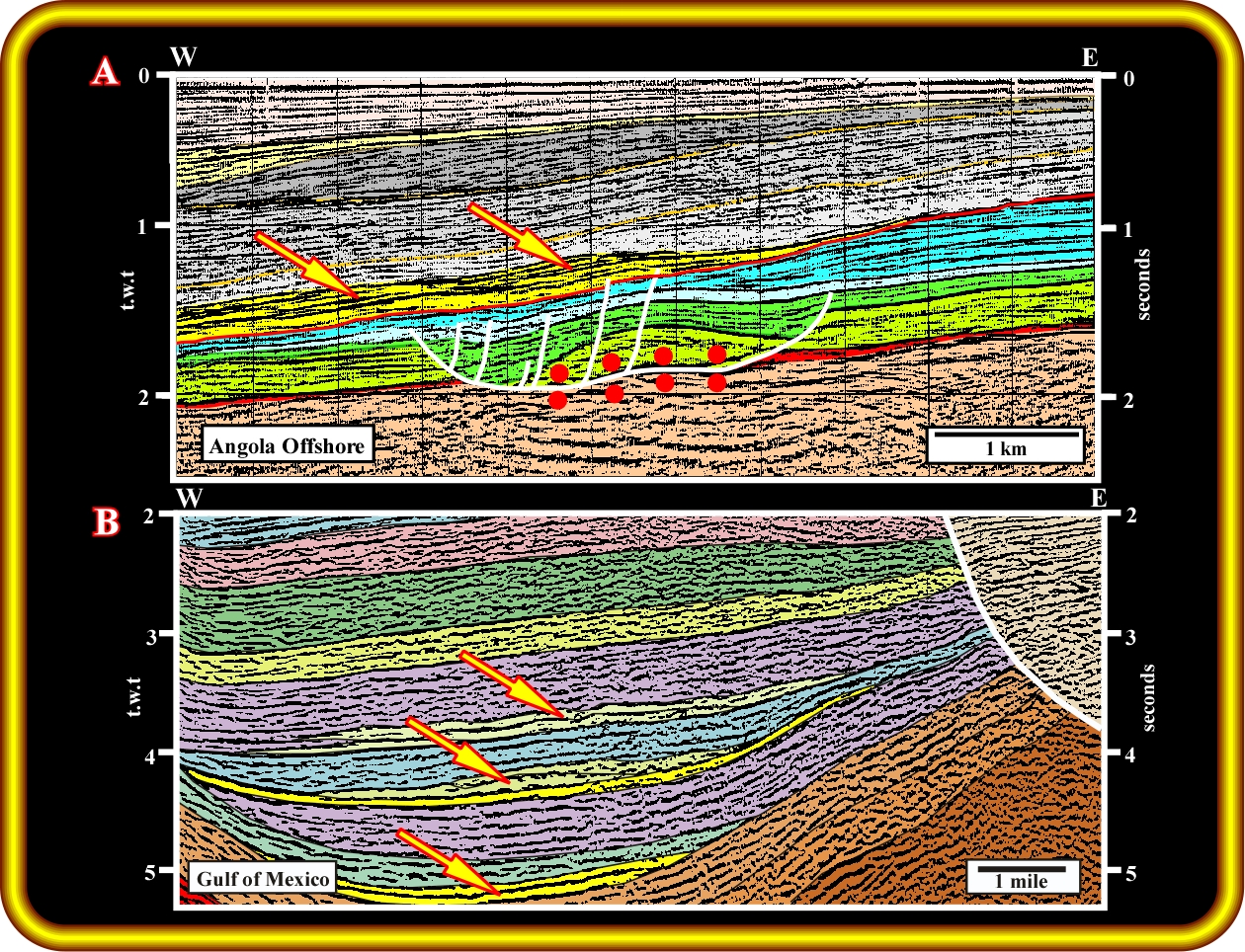
Figure 4. Subsalt breakup unconformity in (A) offshore northern Kwanza Basin and (B) Destin Dome region of offshore Mississippi. Soon after the onset of seafloor spreading, divergent margins are typically upwarped for reasons that are still poorly understood: this upwarp could be either a flexural response to loading by the rift basins or caused by changes in the stress regime of plate kinematics. Either way, this upwarp leads to erosional truncation across much of the basin, which forms a major unconformity which is slightl younger than the breakup and therefore traditionally called the “breakup unconformity.” The unconformity separates landward-dipping rift sediments in half grabens from overlying seaward-dipping margin sediments. In Angola, the equivalent unconformity represents only a brief hiatus of a few million years in the Early Cretaceous. Conversely, in the Gulf of Mexico, which represents a major hiatus of 40 Ma in the Early Jurassic.
Generating Petroleum Subsystem
Lower Cretaceous rift basins in the Angolan margins are rich in lacustrine source rocks compared with rift basins of the Gulf of Mexico. The Triassic rift basins in the Gulf of Mexico formed during low eustatic sea level under arid climates— conditions unfavorable for lacustrine environments. Moreover, the Triassic rift basins surrounding the Gulf contain divergent reflectors, suggesting that the extension rate was balanced by the aggradation rate, so water remained shallow, oxygenated, and filled by red beds. In contrast, the Lower Cretaceous rift basins of the Angolan margin, particularly in the Lower Congo Basin, contain subparallel onlapping reflectors, indicating that the extension rate was faster than the aggradation rate. Consequently, lacustrine environments were created, which favored abundant organic production preserved by anoxic lake bottoms.
Organic content varies markedly along the Angolan margin. Generally, the Lower Congo rift basins have rich lacustrine source rocks, whereas the Kwanza rift basins seem to have sparser organic matter because the rifts tend to be narrow and shallow and filled by graywackes onshore. Thus, they are easily infilled by clastic influx, which prevents the formation of deep anoxic lakes.
Potential source rocks are also developed in the Upper Cretaceous or even Tertiary intervals of the Kwanza Basin, particularly offshore. Yet, except for the onshore Quenguela Field, no economic hydrocarbons accumulations remain south of the Ambriz arch, which separates the Kwanza and Lower Congo Basins. The Quenguela hydrocarbons were generated from a particular Eocene source rock deposited in the core of the Quenguela turtle structure. This source rock has not been found in the younger turtle structures farther seaward. Old onshore fields, such as Benfica, Cabo Ledo, Galinda and Tobias, which produced less than 10-15 MBO each, are associated with the restricted Quissama salt subbasin and overlying Tuenza lagoonal source rocks. Farther seaward, similar Cretaceous source rocks are possible, but seismic data indicate that these are mostly above the oil window.
Maturation
Salt tectonics can strongly enhance or delay maturation of source rocks above and below salt bodies. Salt has a much higher thermal conductivity than other rocks, so isotherms for solid-state conduction are depressed below autochthonous salt and in the overburden below allochthonous salt. In these subsalt regions, maturation is delayed, and the oil window is depressed. Conversely, above salt bodies, isotherms are elevated, which accelerates maturation and raises the oil window. This effect can be important because of the large size of allochthonous salt bodies.
Reservoir Subsystem
Both continental margins have important Cretaceous reservoirs dominated by carbonates and Tertiary reservoirs dominated by turbidites.
Migration Subsystem
In both continental margins, the migration of hydrocarbons is greatly controlled by structures related to salt tectonics, even though one of the primary source rocks in Angola are below the autochthonous salt. Near the landward limit of these salt basins, migration is largely horizontal with low impedance along seal-reservoir doublets. However, in most other parts of the basins, the migration of hydrocarbons is strongly controlled by the highly variable geometry of:(1) impermeable salt bodies, (2) impermeable fault smears, (3) permeable salt welds, and (4) permeable damage zones adjacent to faults. Fluids can drain upward through subsalt strata then obliquely along the sealing base of inclined sheets of allochthonous salt. This lateral subsalt migration could be for large distances, given the enormous size of allochthonous salt sheets in the Gulf of Mexico.
One of the main uncertainties concerning vertical migration of hydrocarbons involves the nature of salt welds. Salt welds formed from both autochthonous or allochthonous salt could act as either barriers or windows for migration. Behavior depends on how much salt remains in welds and other factors affecting permeability. The thickness of a salt weld is below seismic resolution, and it has proven intractable from seismic data alone to distinguish between the residual presence or total absence of salt in welds. Direct answers come from the drill. For example, Chio #1 well, drilled by Total in the onshore Kwanza Basin in 1970, cored a salt weld. This core has a knife-sharp weld between subhorizontal infrasalt Cuvo sandstones and dipping overlying Tertiary shales. No halite remains in this particular salt weld, but abundant halite spots are disseminated for 10 cm wide below the weld. However, far more drilled examples are needed before reliable predictions can be made.
Entrapment Subsystem
In both basins, the migration of hydrocarbons is largely controlled by salt tectonic structures, even though one of the primary source rocks in Angola are below the autochthonous salt. Near the landward limit of these salt basins, migration is largely horizontal with low impedance along seal-reservoir doublets. However, in most other parts of the basins, the migration of hydrocarbons is strongly controlled by the highly variable geometry of : (1) Impermeable salt bodies ; (2) Impermeable fault smears ; (3) permeable salt welds and (4) permeable damage zones adjacent to faults. As illustrated fluids drain obliquely upward through strata along the base of inclined sheets of allochthonous salt. This subsalt process is a key exploration parameter in the Gulf of Mexico and may be equally important in the deepwater of Angola. In both basins, almost all structural and combination traps are created or influenced by salt tectonics.In a talk of this length, there is not enough time to describe individual trap types, but the slides ) show a variety of structural traps in Angola and the Gulf of Mexico.
Slide n°1
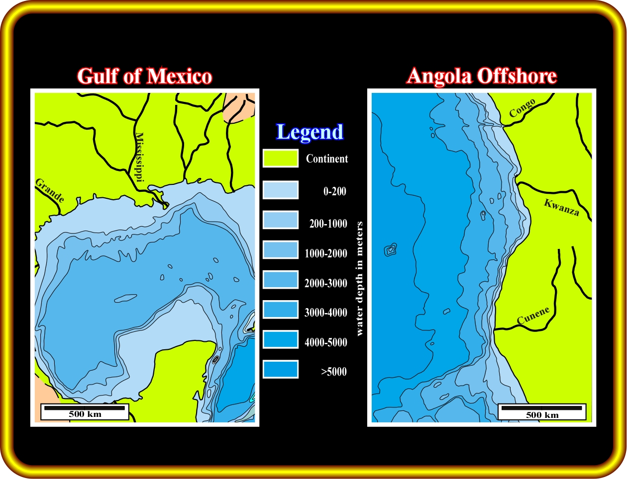
Slide n°1- Location maps where the seismic lines and geological cross-sections from Angola and Gulf of Mexico were taken.
Slide n°2
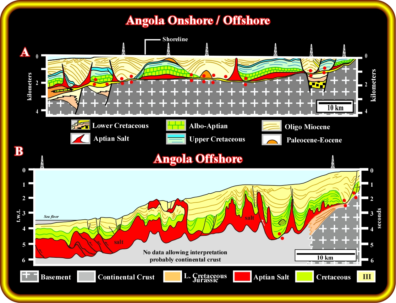
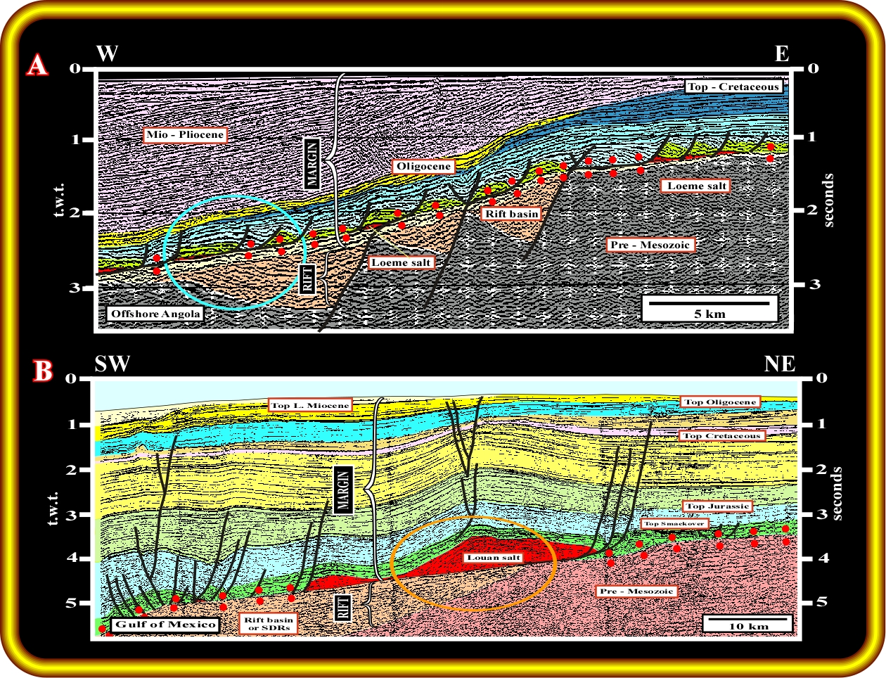
Slide n°2 - Regional seismic lines and geological cross-secvtion (Angola onshore) showing characteristic style of salt tectonics in (A) onshore proximal part of northern Kwanza Basin and (B) offshore distal part of southern Kwanza Basin. The Aptian Loeme salt has highly variable thickness but remains laterally continuous in these lines, although this is atypical. On the far right of the upper section is the landward pinchout of the salt. On the far left of the lower section, the salt is inferred to pile up against oceanic crust. A limited amount of allochthonous salt has been emplaced at higher levels.
Slide n°3

Slide n°3 - Regional seismic lines showing characteristic style of salt tectonics in (A) onshore proximal part of Gulf of Mexico and (B) offshore distal part of Gulf of Mexico. A peripheral graben formed above the landward pinchout of the Louann salt, just as in Angola. In the Gulf, the allochthonous salt is more voluminous.
Slide n°4
Slide n°4- Subsalt breakup unconformity in (A) offshore northern Kwanza Basin and (B) Destin Dome region of offshore Alabama. Soon after sea-floor spreading begins, divergent margins are typically upwarped for reasons that are still poorly understood. This upwarp could be (1) a flexural response to crustal loading by the rift basins, (2) gentle doming induced by an underlying mantle plume, or (3) caused by changes in the stress regime of plate kinematics. Whatever its cause, this upwarp leads to erosional truncation across much of the continental margin, which forms a major breakup unconformity. The unconformity separates generally landward-dipping rift sediments in half grabens from overlying seaward-dipping margin sediments. In Angola, the breakup unconformity represents a brief hiatus of a few million years in the Early Cretaceous. Conversely, in the Gulf of Mexico, the equivalent unconformity represents a major hiatus of 40 Ma in the Early Jurassic.
Slide n°5
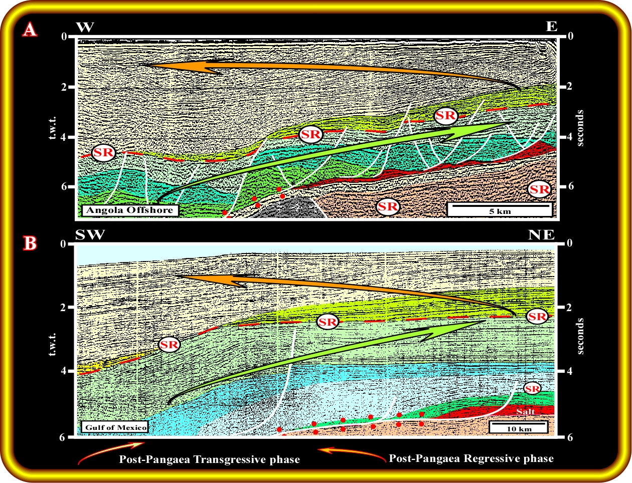
Slide n°5- Upper Cretaceous potential source-rock intervals in (A) offshore Kwanza Basin, and (B) offshore Gulf of Mexico. The backstepping transgressive phase of the post-Pangaea continental encroachment stratigraphic cycle was terminated by a major downlap surface. This surface marks the time of maximum flooding of the margins when primary marine source rocks accumulated. This was succeeded by the progradational regressive phase. Each continental cycle comprises several subcycles, within which secondary marine source rocks are associated with minor downlap surfaces. The occurrence of source rocks is mostly unrelated to the salt tectonics.
Slide n°6
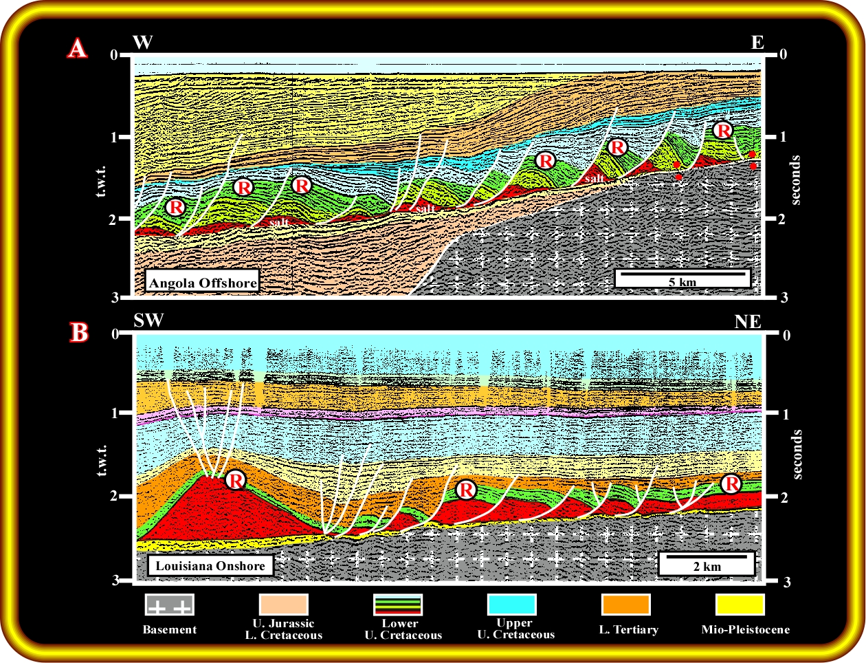
Slide n°6- Upper Cretaceous reservoir rocks in offshore Kwanza Basin (A) and in the Gulf of Mexico (B). In both margins, these reservoirs have been disrupted and dismembered by raft tectonics. The Cretaceous reservoirs accumulated during the earliest stage of thin-skinned extension of the divergent margins, a setting that strongly controlled both reservoir facies and their geometry, as shown in the following illustration.
Slide n°7
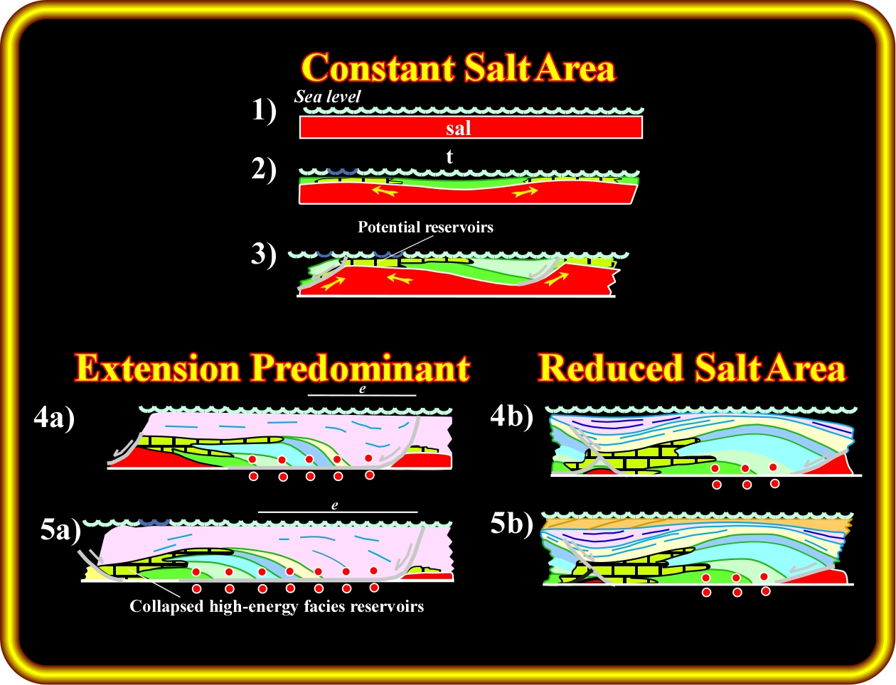
Figure 7- Two schematic tectonic scenarios for the development of Albian-Cenomanian carbonate reservoirs in the Pinda Formation of Kwanza Basin. ((Stages 1-5a) Assuming both salt reduction and subsidence of diapiric flanks induced by thin-skinned extension. (Stages 1-5b) Assuming merely salt reduction without extension. Both evolutions have some similar effects on carbonate reservoirs. Potential reservoirs initially form in high-energy environments over structural highs. However, , these initial structural highs are inverted by deformation into structural lows after the underlying salt is withdrawn. A major difference in the two evolutions is that shoal facies are transported many kilometers down the slope into deeper water by extension but not by salt reduction. Paleofacies mapping requires structural restorations to refit the rafts together to their pre-extensional positions.
Slide n°8
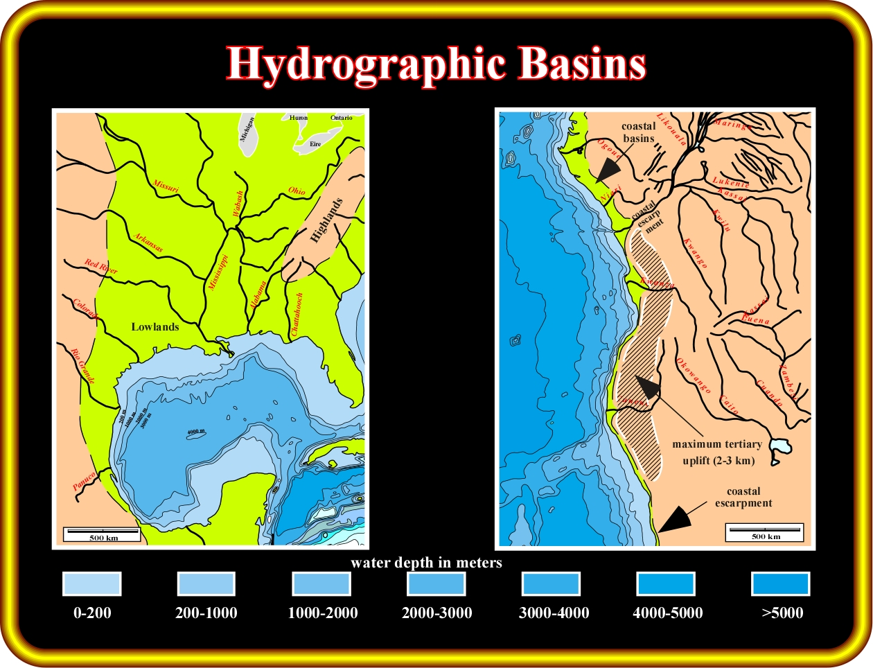
Slide n°8- Comparison of hydrographic basins supplying siliciclastic sediments for Tertiary reservoirs. (A) The catchment area is small in Angola because an estimated 2–3 km of epeirogenic Tertiary uplift along the coast (Sahagian, 1988) tilted the Angolan craton eastward. That diverted rivers inland and northward away from the Angolan coast. As a result, the only one major river, the Congo, and one moderate river, the Kwanza, provide significant sediment sources. Moreover, the Congo and Kwanza rivers reached the Angolan shoreline through gorges in the coastal escarpment, which prevent the deltas shifting laterally and thus restricted the deposition of turbiditic reservoir sands. The maximum thickness of Cenozoic sediments is typically only about 2.5 km of Angola but reaches about 5 km in the Congo delta, which has the best potential for turbiditic reservoir sands. This restricted sediment supply off the Angolan margin is reflected by the narrow continental shelf. (B) Conversely, the catchment area in the Gulf of Mexico is much larger. Many large rivers to migrated extensively across a wide expanse of lowlands. Lateral shifting combined with abundant terrigenous influx from the Rockies deposited large quantities of sands on the shelf. The maximum Cenozoic thickness in the Gulf of Mexico is about 16 km, which is 3 to 6 times the equivalent thickness in Angola. This great thickness of sediments in the Gulf was accommodated by three processes: (1) thermal subsidence due to cooling of lithosphere, (2) isostatic subsidence due the weight of sediments, and (3) evacuation of 4–6 km of underlying salt to form allochthonous sheets. The Kwanza, provide significant sediment sources. Moreover, the Congo and Kwanza rivers reached the Angolan shoreline through gorges in the coastal escarpment, which prevent the deltas shifting laterally and thus restricted the deposition of potentioal reservoirs-rocks.
Slide n°9
Slide n°9- Tertiary reservoirs in both continental margins are mainly turbidites. During relative fall of sea level, sand-rich sediments are eroded and transported by gravity currents onto the slope or continental rise to be deposited in basin or slope-fan complexes. Turbiditic channel-levee complexes are recognizable in strike sections by a “gullwing” pattern of reflectors where direct indicators of hydrocarbons can be recognized. This pattern comprises a flat-bottomed basin-floor fan overlain by a central sand-prone channel flanked by outward dipping apron and overbank strata, capped by abandonment shales. Salt tectonics controls bathymetry which, in turn controls the pathways of Tertiary turbiditic currents and location of turbiditic reservoirs. Turbidites can be stacked within (1) grabens over the crest of a salt structure, (2) turtle structures between separating raft blocks, (3) minibasins sinking into allochthonous salt sheets. Subsalt reservoirs are especially important in the Gulf. These reservoirs are initially uncompacted because the overlying salt sheets are emplaced at the surface. The subsalt sediments remain undercompacted because the impermeable salt prevents them from dewatering, and the fluids must travel far beneath the salt sheets to escape. (A) Offshore Angola. Here, turbidite reservoirs onlap the base-Tertiary unconformity. (B) offshore Gulf of Mexico. Similar stratigraphic features to those in (A) are shown here.
Slide n°10
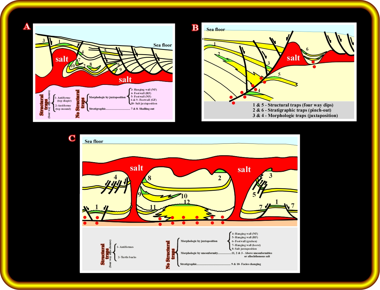
Slide n°10- In both continental margins, almost all structural and combination traps are created or influenced by salt tectonics. This illustration shows potential traps related to salt tectonics in Angola and the Gulf of Mexico.

Send E-mail to carloscramez@gmail.com with questions or comments about this conference.
Copyright © 1997, Fonck,Cramez& Jackson
Last modification: August, 2014