
A downlap is a discordant geometric configuration, in which initially inclined strata terminate downdip against an initially horizontal or inclined surface.
Several different kinds of downlap can be considered:
a) Distal downlap ;
b) False downlap ;
c) Shelf downlap ;
d) Basin downlap ;
e) Opposite (local) downlap ;
f) Apparent downlap.
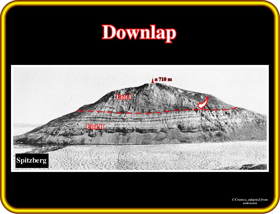
Plate 154 - On this photograph, it is easy to recognize that a calcareous inclined strata (Unit I) terminates on much less inclined strata (Unit II). This geometrical relationship is called downlap. Therefore, one can say that a downlap surface, characterized by stratal or seismic reflection terminations, exits between Unit I and II. Downlap surfaces are not unconformities (erosional surfaces), since they correspond mainly to a non-depositional time-gap. However, in the deep parts of a basin, downlap surfaces associated with the downdip terminations of the continental slope progradations can correspond with paraconformities, which are correlable updip with unconformities. In other words, in deep water environments, downlap surfaces can coincide with surfaces bounding stratigraphic cycles.
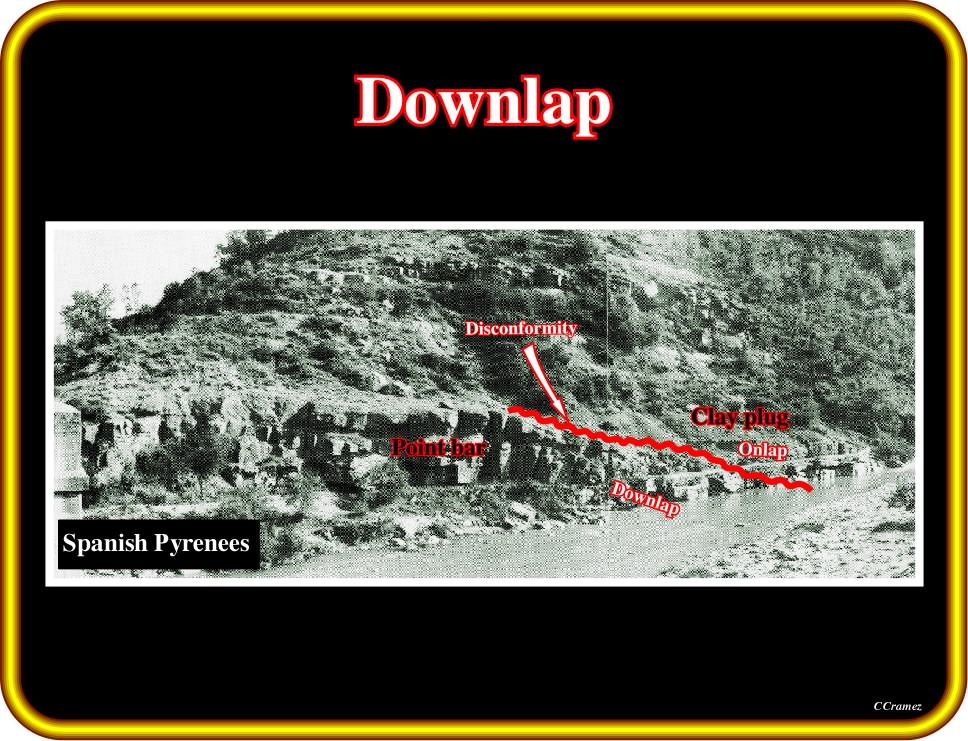
Plate 155 - Downlap geometric relationships exist also in non-marine sediments, particularly in fluvial environments, as illustrated here by the point bar. The inclined strata of the point bar terminate downdip against a fluvial erosional surface (not visible). A local disconformity (in red), created probably by a neck-cutoff (high-angle meander cutoff formed where a stream breaks through or across a narrow meander neck, as where downstream migration of one meander has been slowed and the next meander upstream has overtaken it) of the stream, was fossilized by a clay plug. The shales of the clay-plug are onlapping the disconformity limiting the point-bar. In this kind of environment, in which erosion and deposition are synchronous, the term disconformity fits better than unconformity or non-conformity to label the observed sedimentary hiatus.
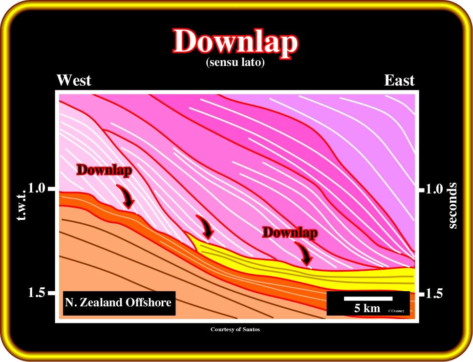
Plate 156 - On this tentative interpretation (seismic line of offshore New Zealand), downlap geometrical relationships are paramount on the progradational units. In fact, seaward inclined seismic reflections (chronostratigraphic lines) terminate against subhorizontal strata. Taking into account the vertical (t.w.t., two way time) and horizontal scales, the pristine inclined reflections correspond to continental slopes. Therefore, one can say, they express, roughly, the direction away from the source for clastic supply. Briefly speaking, downlaps indicate the seaward direction.
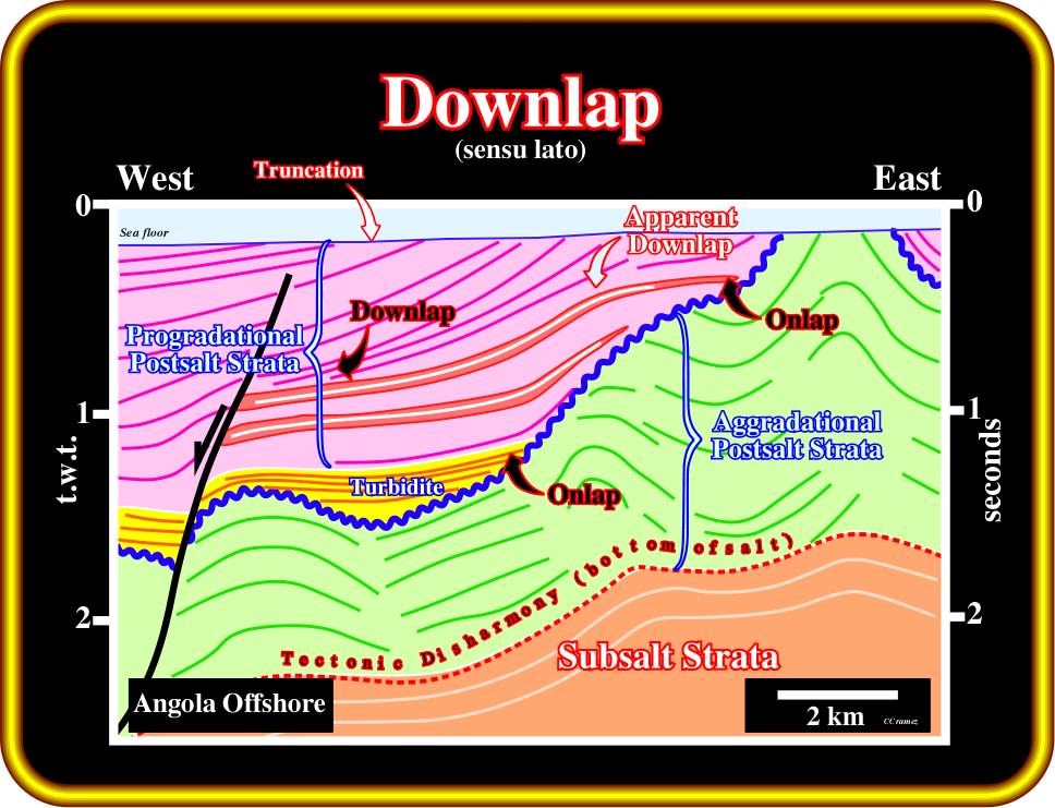
Plate 157 - 0n this line tentative interpretation of a seismic line of Angola offshore, three principal sedimentary packages are recognized: (i) subsalt, (ii) aggradational and (iii) progradational postsalt strata. In the upper package, several types of reflection terminations can be identified. Onlaps are associated with the turbidite unit (onlap against the major unconformity). Downlaps are associated with the downdip terminations of some progradational reflections, while onlaps characterize the updip terminations. Two apparent downlaps (see later), with downdip tangential terminations (in brown), as well as truncations along the uppermost unconformity (sea floor), are also easily perceived. On salt basins as in South Atlantic margins is quite important not forget that the limit between infra and suprasalt sediments (or base of sal) does not correspond to a major stratigraphic or basin event. Hence, when a geoscientist speaks in infrasalt source rocks, he must stipulate if the potential source rocks are in the rift-type basin (below the break-up uniformity) or in the divergent margin (above the break-up unconformity).
(i) Distal Downlap
A distal downlap is a downlap in the direction away from the source of clastic supply. The majority of downlaps are distal downlaps.
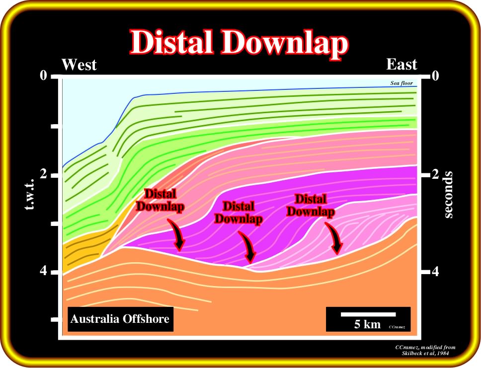
Plate 158 - In the upper stratigraphic levels of post-Pangea Atlantic-type divergent margins, as depicted in this tentative interpretation of a seismic line of offshore Australia, progradational intervals are very common. Such intervals have a forestepping geometry and distal downlaps. The downlaps are parallel to the direction of the clastic supply. Progradational intervals are, generally, associated with a global (eustatic) falling of sea level. However, progradational sedimentary intervals take place during decreasing relative sea level rises, which globally form the eustatic falling. Indeed, when a relative sea level fall of 10 m is followed by 7 m of relative sea level rise, then a fall of 12 m, a rise of 8 m, a fall of 15 m and a rise of 10, at the end there is global falling of 12 m. Forestepping units are deposited during successive decreasing relative sea level rises, in which coastal aggradation is progressively smaller and smaller. Deposition requires a relative sea level rise (increasing in accommodation), however, the rising of the sea level can be in acceleration (transgressive intervals) or in deceleration (regressive intervals). Making a long history short: there are no sediments coming from the sea although few can be formed in the sea (carbonates).
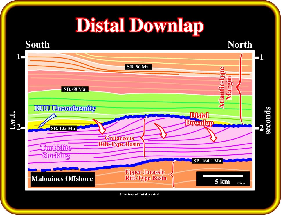
Plate 159 - Distal downlaps, i.e. downlaps in the direction away from the source of the clastic supply, often indicate the direction of terrigeneous supply, as pictured above (Cretaceous rift-type basin). In this particular example (tentative interpretation of a seismic line of the offshore north of Malouines) some distal downlaps look like apparent downlaps (see later). The inclined reflections do not seem terminate downdip, they flatten and continue seaward. Such a seaward continuation of the reflections can be apparent. It can be induced by low resolution of the seismic data. In fact, geological speaking, there is a sharp facies change between the dipping reflectors (slope shales) and the flat reflectors (turbidite sandstones). The mounded sedimentological anomalies are slightly disconnected from the toe of slope progradations.
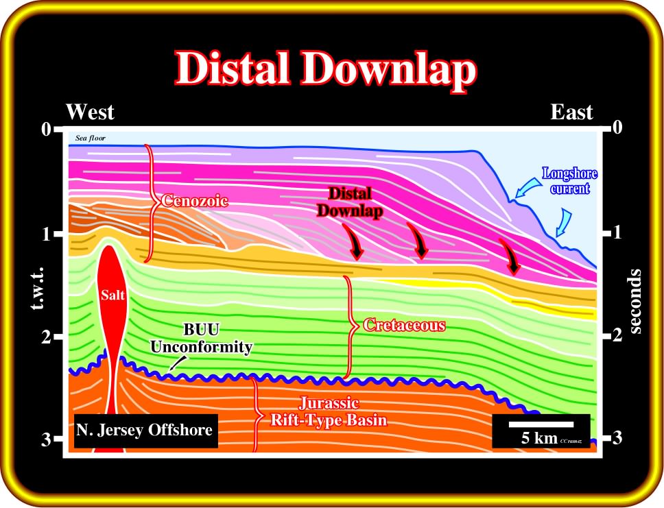
Plate 160 - On this tentative interpretation of a regional line shot in Baltimore Canyon (offshore New Jersey, USA), distal downlaps are recognized in Cenozoic progradational units, which, genetically, are eustatically induced. In fact, during the Cenozoic, tectonic subsidence was negligible (landward of the successive shelf breaks the geometry of the horizons is horizontal). In spite of the strong activity of longshore currents, these distal downlaps clearly indicate terrigeneous influx coming from the west. Longshore currents, which generally are limited to the surf zone and formed by waves approaching the coast at an oblique angle, eroded the upper slope (basin without platform) creating channel-like depressions parallel to the coastline. Later, these depressions were filled by lateral terrigeneous influx. The facies of such filled-depressions (contourites for some geoscientists) is shale free and full of heavy minerals, as is the case in flysch of the Alps.
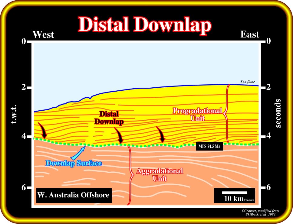
Plate 161 - As illustrated in this tentative interpretation, successive distal downlaps create a downlap seismic surface which is characterized by an increasing seaward time-gap (hiatus). Downlap surfaces are developed during eustatic highs and they obey the same hierarchy as eustatic cycles. Downlap surfaces induced by 1st order eustatic cycles are often called major downlap surfaces. Since the Phanerozoic, there are two major downlap surfaces. Both separate the transgressive (backstepping) and regressive (forestepping) phases of the continental encroachment cycles (Paleozoic and Meso-Cenozoic cycles).
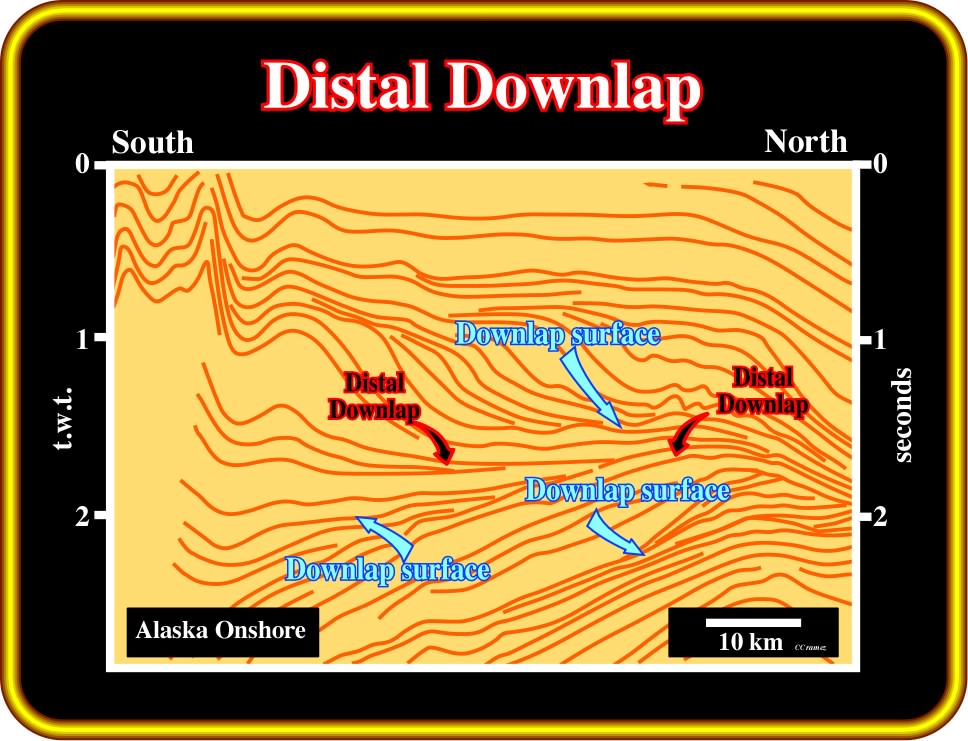
Plate 162 - On this tentative interpretation of a regional line of offshore Alaska, distal downlaps with opposite vergences define two significant downlap surfaces, which represent the closure of a sea, caused by the collision between two continents. The lower downlap surface, along which distal onlaps look southward, suggests a continent northward and a sea southward. On the contrary, the upper downlap surface suggests a sea northward and a continent southward Subsequently, according to the Plate Tectonics paradigm, it is logical to hypothesize the closure of a sea as the continents collided (closure of Tethys sea). In fact, oceans come and go as a result of the movement of the lithospheric plates.
(ii) False Downlap
A false downlap is a downdip tangential stratal termination. Strata flatten and continue as units, which, often, are so thin that they fall below the seismic resolution.
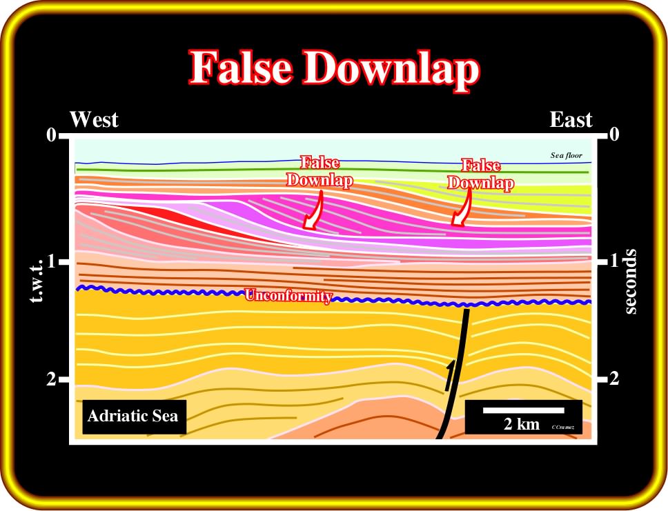
Plate 163 - As illustrated on this tentative interpretation, the depositional oblique reflectors flatten downdip and continue seaward as sedimentary units, where their thickness can increase slightly. Before considering a downlap as a false downlap, interpreters must be sure that the tangential termination is not a consequence of low seismic resolution. If there is a sharp facies change between the oblique (shale) and subhorizontal (sand) segments, there is a downdip strata termination, and so it must be considered as a downlap.
(iii) Shelf Downlap
A shelf downlap is a downlap recognized in a shelf. Often, it underlies the slope of a depositional coastal break. The water depth is less than 200 meters (prodelta).
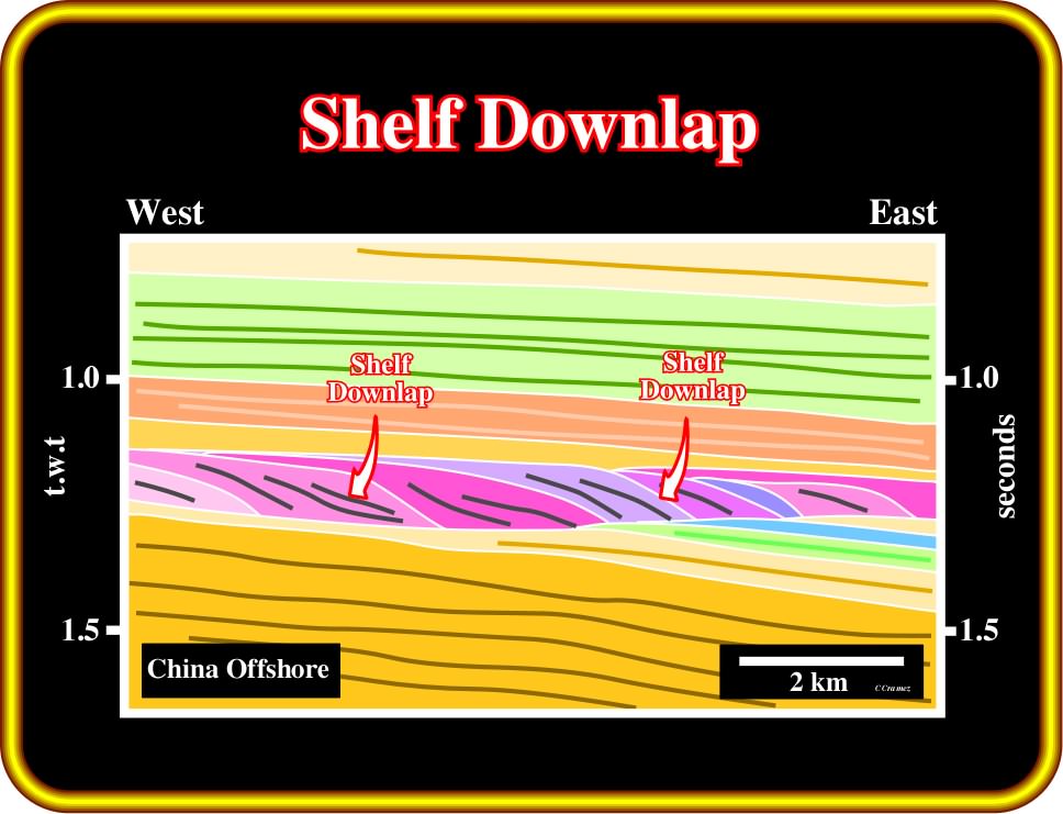
Plate 164 - Taking into account the vertical scale (t.w.t.), it is evident that the inclined seaward reflectors likely correspond to a deltaic slope. In fact, the time-difference between the updip and downdip terminations is less than 200 milliseconds (two way time). Therefore, their downdip terminations can be considered as shelf downlap. Notice that within the progradational interval (deltaic environment), the relative sea level falls and /or the lateral shift of the deltaic lobes are denoted by subtle onlap surfaces (defined by the progradation).
(iv) Shelf Downlap
A slope downlap is a downlap associated with a continental slope. The water depth is higher than 200 meters.
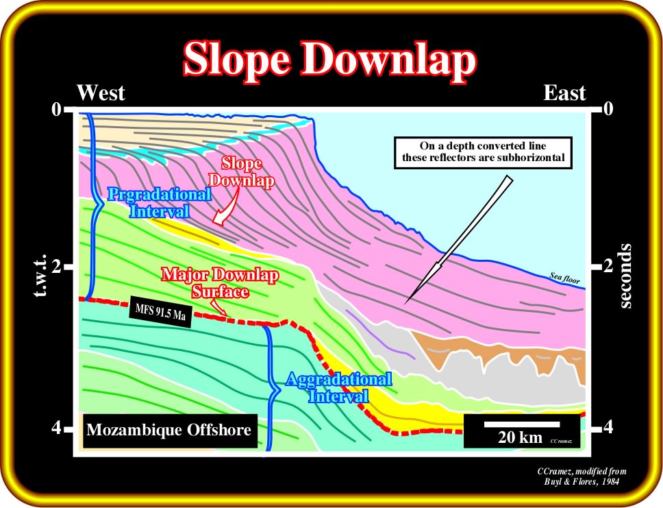
Plate 165- Contrariwise to shelf downlaps (see Plate 164), on this geological tentative interpretation, the downlaps are slope downlaps, that is to say, the depositional inclined reflectors emphasize the successive morphologies of the continental slope. Take into account the pitfall (an unforeseen or unexpected or surprising difficulty) induced by the abrupt change in the water depth. Indeed, in a depth converted inversion of the original line, the reflectors seaward of the present-day shelf break are subhorizontal or gently dipping seaward.
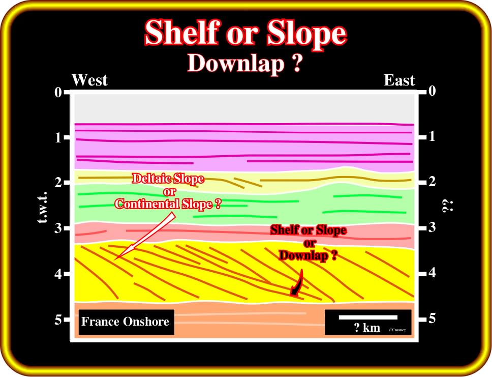
Plate 166 - On the previous tentative interpretations, it is possible to differentiate shelf downlaps, associated with deltaic slopes, from slope downlaps associated with continental slopes, using the vertical and horizontal scales. Geology is scale dependent and so seismic interpretation can only be correctly performed knowing the scales of the seismic data. On this tentative interpretation, in which the vertical scale was deliberately omitted, geoscientists are unable to correctly interpret the depositional inclined reflectors. They will be obliged to make a guess : shelf or slope downlaps? Note that very often, particularly in major oil companies, dominated by the confidentiality complex, give to their own geoscientists seismic data without scale and location, that is to say, they hide them the fundamental information to performed coherent tentative geological interpretations.
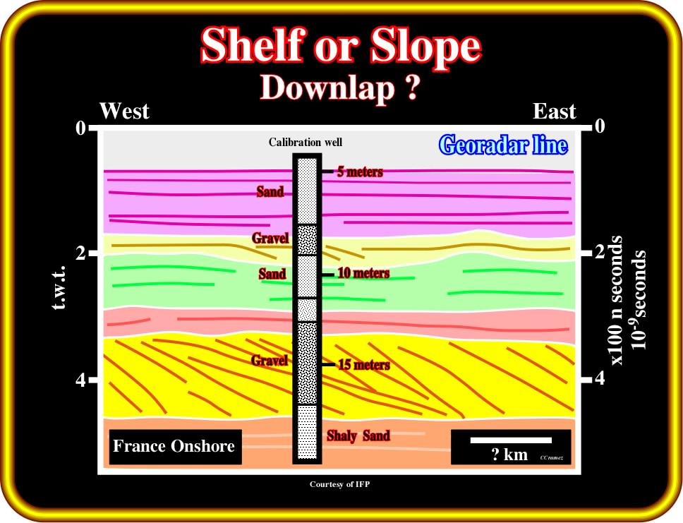
Plate 167- In fact, the vertical scale of the previous tentative interpretation is in nanoseconds, that is to say, 10-9 seconds (one billionth of a second or one thousand millionth part of a second). In other words, the original line is a georadar line shot in onshore France (Pin Sec). The proposed interpretation was later tested by a calibration well showing georadar velocities ranging from 8 ns in the shaly sands, to 13 ns in the gravel (georadar is an electromagnetic device to establish a profile based on the topography, the dielectric permittivity and conductivity). Velocities of 15 ns were found in the upper sand interval. The depositional inclined reflectors are not associated with a deltaic or continental slope, but are rather small oblique bedding planes. one thousand millionth part of a second. Note that the nanosecond unit is not only used in georadar measure, but is also the unit in which the fundamental logical operations of modern digital circuits are typically measured (the microprocessor within which I'm righting theses notes has a clock frequency of 100 megahertz and a 10 nanosecond clock period).
(v) Opposite Downlaps
Opposite downlaps are characteristics of overbank deposits, whether associated with fluvial or turbiditic levees.
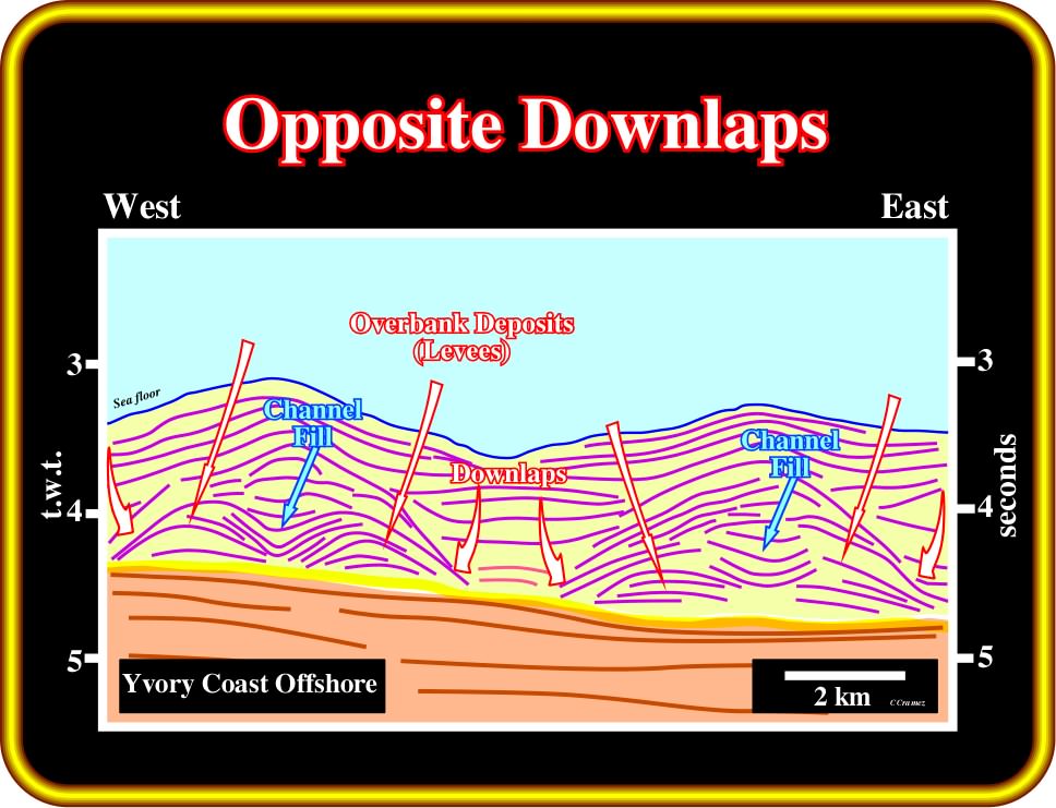
Plate 168 - On this tentative interpretation of a line from the Ivory Coast deep-water, where turbidite channel-levees complexes (“gull wings” of P. Vail) are paramount, opposite downlaps are easily recognized in the overbank deposits. Admittedly, these downlaps cannot be considered as distal, since they do not indicate the regional direction of the source of the clastic supply. On the contrary, they indicate the local direction of the overbank currents, that is to say, the local sediment transport-direction, which is away (roughly perpendicular) from the central troughs (often called “channels”).
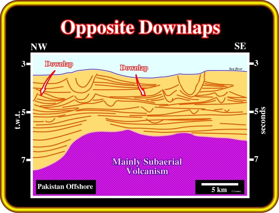
Plate 169 - On this tentative interpretation (seismic lines from Indus offshore), opposite downlaps are the preponderant reflection terminations. They are associated with turbidite slope depositional systems, particularly with channel-levees complexes, in association with the overbank deposits (turbiditic levees). As illustrated on this tentative interpretation, the seismic reflections can only be depositional. In other words, the observed dips are depositional and not post-depositional tectonic dips (tectonic dips). They cannot be explained by any known tectonic model. At present time, all geologists associate the “gully wings” of P. Vail with slope fan turbidites. However, in the 60's and 70's, the majority of exploration wells drilled for instance, in the Cameroon offshore (Matanda, Sulebaba, etc.), were supposed to test structural traps (four way dip closure), but, in fact, they tested mainly channel-levees complexes (“gull wings”), i.e., the opposite downlaps were considered as structural dips.
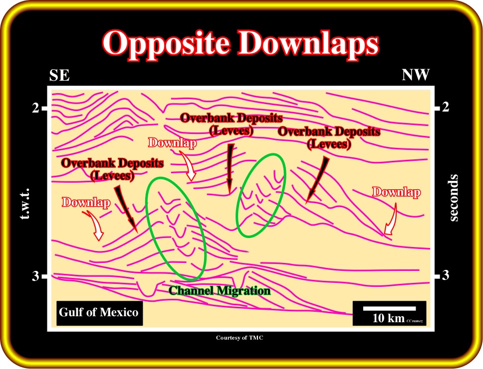
Plate 170 - Modern seismic lines, like the one in which this tentative interpretation is based (Gulf of Mexico), show so many details that sometimes interpreters have difficulty recognizing the main characteristics of geological models. In fact, on this tentative, the opposite downlaps associated with the deep-water turbidite channel-levees complexes are much more difficult to recognize than the migration of the turbidite channels. It is interesting to notice that, at least in this particular example, one cannot related the size (height) of the channel-levee complex with the height of the turbidite currents. Indeed, due to lateral and vertical migration of the channel, even a small gravity current cannot be contained within the channel and so it overbanks.
(vi) Apparent Downlap
An apparent downlap is an original onlap termination deformed by tectonics or halokinesis (salt tectonics), which, apparently, takes a downlap geometry.
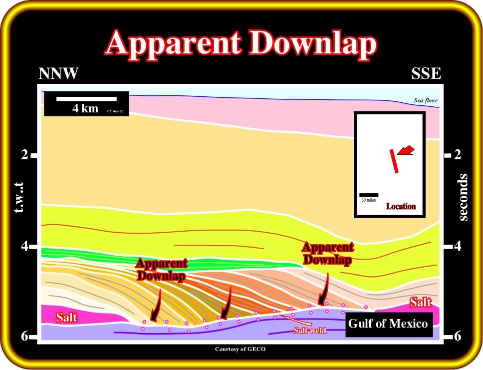
Plate 171 - The presence of autochthonous salt relics along the major disconformity (salt weld) strongly suggests that the reflection terminations against it are apparent downlaps, i.e., original onlaps tilted seaward as the salt flowed laterally. Actually, these oblique reflections cannot be interpreted as progradations, since they thick towards the décollement plane (salt-induced tectonic disharmony). It is interesting to point out that in 1986, arriving in Houston from Angola (where halokinesis was well known of all geoscientists working in the Kwanza and Congo basins), using the original seismic line, I spent several hours explaining to the godfathers of Petroleum Geology that these inclined reflectors should not be interpreted as Cretaceous continental slope progradations, but as tilted onlap due to salt flowage.
to continue press![]()
![]()