
Discontinuity surfaces are surfaces caused by to erosion or depositional hiatus.
An unconformity is an erosional surface created by a significant relative sea level fall relative, which, generally, puts the sea level below the shelf break (lowstand geological condition). Unconformities can be local enhanced by tectonics.
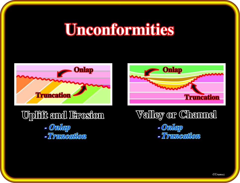
Plate 184 - Unconformities or erosional surfaces can be recognized on the field and seismic lines, below and above strata or reflection terminations. Generally, such a surfaces are induced by relative sea level falls created by the combination of the subsidence or uplift (Tectonics) and eustasy. However, the cyclicity is basically associated with the eustasy and not tectonics Incised valley as the one illustrated above are good indicators of unconformities, which, generally are cryptic landward of the shelf break area.
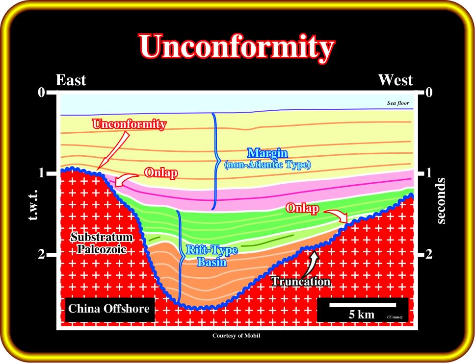
Plate 185 - On this tentative interpretation of an China offshore seismic line, the major unconformity separating the Paleozoic substratum from the Meso-Cenozoic sediments of the rift-type basin and/or the non-Atlantic type margin (on the eastern part of the line) is overlain by onlap reflection terminations. Such reflection terminations are easily recognized in the lower seismic packages, which have a parallel internal configuration. In spite of the fact that in the rift-type basin nonmarine environments are preponderant, the onlaps can indicate successive relative sea level rises. If on a perpendicular seismic line, the internal configuration of the majority of the rift-type basin interval is also parallel, lacustrine episodes (deposition of potential source rocks) are likely during the development of this rift-type basin. The pre-rifting unconformity (top of the Paleozoic substratum, is characterized by onlapping of the rocks above it, and truncation (erosional toplaps) of the underlying rocks.
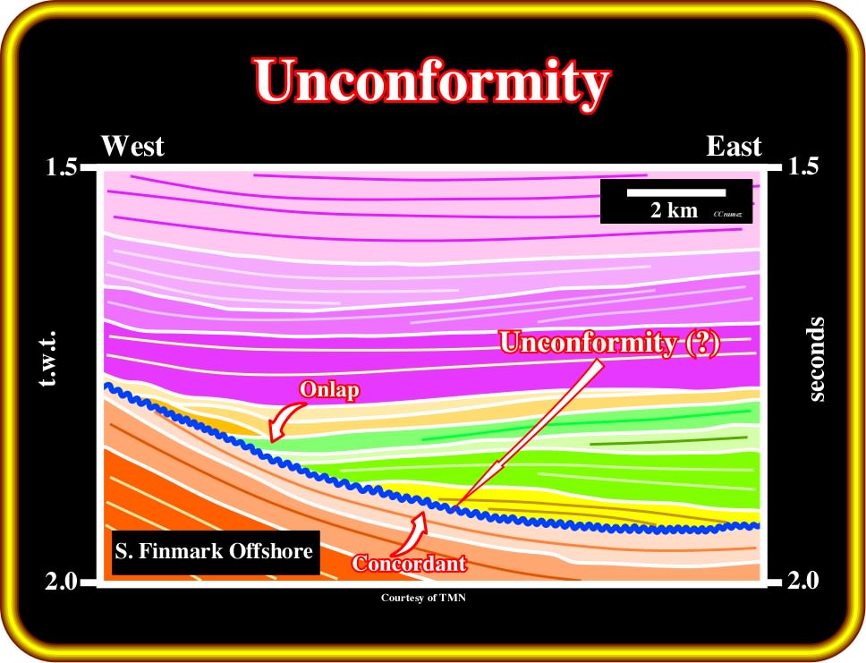
Plate 186 - The unconformity (bin blue) illustrated on this tentative interpretation of a s Norway offshore seismic line, is quite particular. In fact, erosion is not evident due to the concordance between it and the underlying sediments. The sediments overlying it are deep-water sediments (turbidite depositional systems) and the associated reflections terminate in onlap defining a classic onlap seismic surface. Strictly speaking, this onlap seismic surface is not an erosional surface, but, as we will see later, it is correlatable updip with an unconformity, i.e., an erosional surface induced by a significative relative sea level fall. Actually, such a deep-water onlap seismic surface, which locally can show evidence of submarine erosion, bounds a stratigraphic cycle (probably a sequence cycles) and is correlatable updip with a subaerial erosional surface (unconformity).
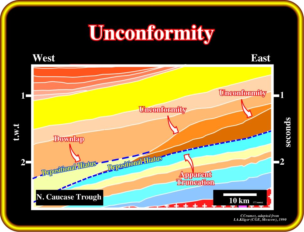
Plate 187- When submarine deep-water erosion is paramount, as for example in deep-water of Gulf of Mexico, the associated truncated seismic surfaces are, by definition, unconformities. On this tentative interpretation (North Caucase trough), the white matkers bounding stratigraphic cycles are unconformity. They are associated with relative sea level fall. However, erosion is not too evident, since it is mainly associated with the break of equilibrium profil of the rivers (incised valleys, canyons, etc.). The markers in blue are not unconformities, but downlap surfaces which highlight significant depositional hiatus (absence in stratigraphic sequence of rocks that were never deposited).
Generally speaking, a hiatus is a break or interruption in the continuity of the geologic record, such as the absence in a stratigraphic sequence of rocks that would normally be present but either were never deposited or were eroded before deposition of the overlying beds (R. Bates & J. Jackson, 1980). A nondepositional hiatus is often considered as the time value of an episode of nondeposition or of nondeposition and erosion together.
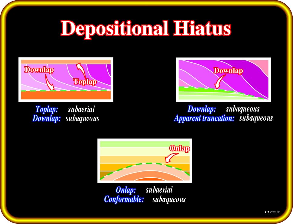
Plate 188- Depositional hiatus are characterized by downlaps with toplap in the upward reflection terminations. However, in certain instances, the interface can be defined by downlaps over apparent truncations or onlaps over a conformable lower sedimentary package. Generally, a toplap and an onlap suggest subaerial environments, while a downlap, apparent truncation (top of a backstepping interval) and a conformable relationship suggest subaqueous environments. Summing up: (i) Onlap and toplap are associated with subaerial environments, While (2) Downlap, apparent truncation and conformity are, mainly, associated with subaqueous environements (occurring under water).
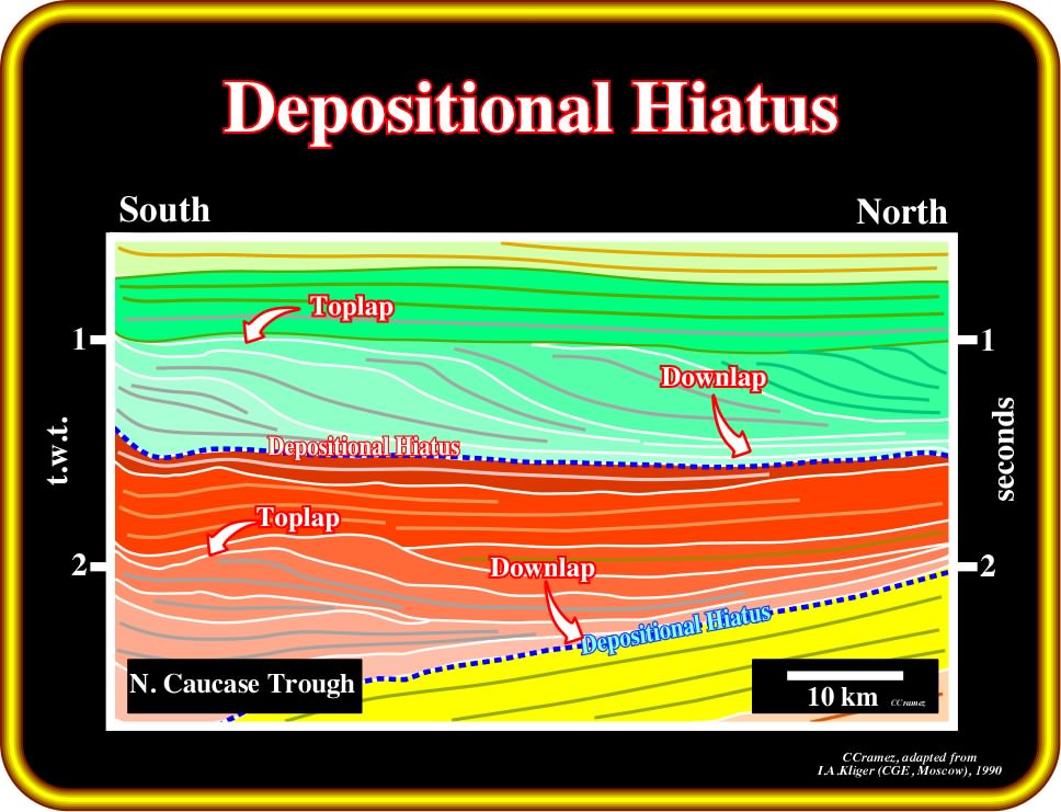
Plate 189 - Two major non-depositional hiatus surfaces (dashed blue) defined by downlap reflection terminations are quite evident on this tentative interpretation (North Caucasus trough). These surfaces emphasize the geologic-time interval during which no strata was deposited at the depositional surface. The progradational (forestepping) geometry of the depositional systems implies a progressive fossilization of an underlying depositional surface. The hiatus duration increases seaward, i.e., in the direction of the downlap terminations. Some of the toplap terminatinations are deposition and other erosional. The first do not highlight cycle boundaries, what is the case for the erosional toplaps.
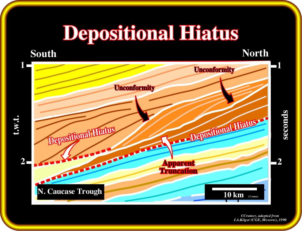
Plate 190 - The lower nondepositional hiatus surface illustrated on this tentative interpretation of a North Caucase Trough seismic line is more complex than those illustrated on Plate 189. In fact, an aggradational turbidite interval (in light yellow), probably basin floor fans, is recognized on the southern part of the line. The geologic-time during which no strata were deposited on the hiatus surface is more difficult to reckon, since the turbidite deposits can be disconnected from the downlap termination (lower limit of the continental slope). After the instantaneous (geological time) deposition of the turbidite interval, a depositional hiatus surface was developed on the top of the turbidites, which was later fossilized by downlap terminations.
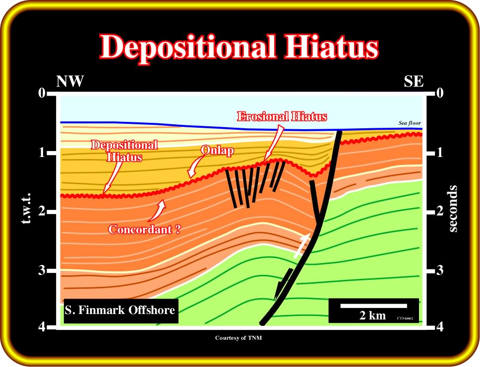
Plate 191 - Taking into account that in this tentative interpretation, erosion is only evident on the apex of the structure (enhanced unconformity). The unconformity on the northern flank can be considered as classic eustatic unconformity. On the northern flank, the hiatus can be considered as a non-depositional hiatus characterized by underlying subaqueous concordant sediments and overlying subaerial (?) onlapping sediments. On the contrary, on the apex of the structure, the hiatus is erosional and refers to the geologic-time range of the strata which was removed by erosion and not the time at which erosion occurred. The shortening of the sediments corresponds to a tectonic inversion, in which older normal faults (the thickness of the uppermost brown is much higher in the hanging wall) were reactivated as reverse faults. However, the tectonic inversion was not total, since the fault keeps the original normal fault geometry (the null point still is the lower part of the fault plane).
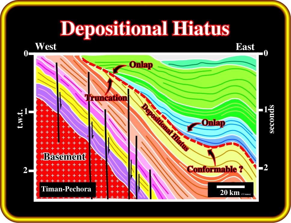
Plate 192 - The hiatus surface recognized on eastern part of this tentative interpretation of a Timan-Pechora (Russia) seismic line can be considered, at least partially, as a non-depositional hiatus surface. Erosion is meaningless. The depositional hiatus surface corresponds to an interface characterized by underlying conformable sediments and overlying onlapping sediments. The upper sediments underlying the depositional surface were significantly eroded. So, the hiatus surface, in this area, must be considered as erosional. Such a surface can be considered as an unconformity or correlatable with an unconformity, i.e., a stratigraphic cycle boundary (see later).
As said previously, an unconformity is an erosional surface that separates younger strata from older rocks and represents a significant hiatus, that is to say, that at least a correlatable part of a geochronologic unit is not represented by strata :
- In very particular cases, an unconformity can corresponds to an non-depositional surface ;
- Periods of erosion and non deposition occur at each global fall of sea level producing interregional unconformities ;
- Although in some areas of continuous deposition, the hiatus may be too small to be detected paleontologically or seismically, and the surface is defined as a conformity.
Let's see few more examples of unconformities:
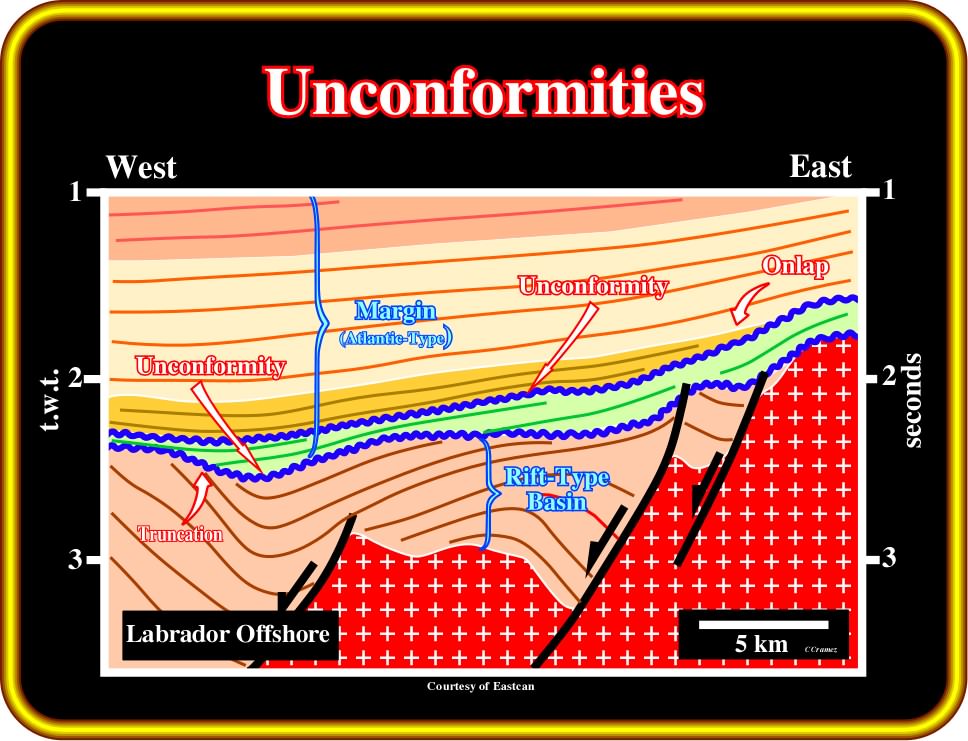
Plate 193 - Two major unconformities, that is to say, erosional surfaces characterized by truncation and onlap reflection terminations, are easily recognized on this tentative interpretation of a seismic line of Labrador offshore. The lower one is the breakup unconformity (BUU). It limits the rift-type sediments from the Atlantic-type margin sediments. The upper one separates the basal fluvio-deltaic sediments of the margin from marine and deep marine sediments. Both unconformities are induced by significant relative sea level falls that put the sea level below the shelf break..
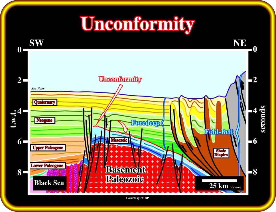
Plate 194 - On this tentative interpretation of a regional seismic line of Black Sea, the major unconformity (in red) is mainly tectonically induced. The loading of the thrusts associated with the folded belt seems to be principally responsible for the unconformity (basal foredeep unconformity). In this particular example, this unconformity is emphasized by the onlap reflection terminations of the foredeep sediments. The underlying sediments roughly conform the unconformity. The presence of volcanic dykes in the southward part of the seismic line suggests an highly intruded basement, which forecast a possible oceanization of the basin.
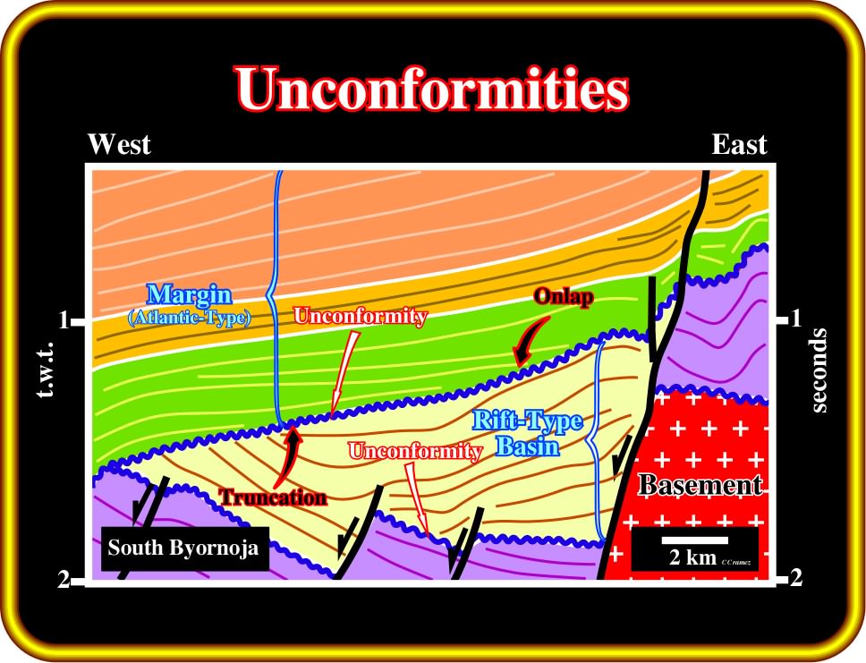
Plate 195 - On this tentative, the upper unconformity is often considered as the breakup unconformity, i.e., the unconformity induced by the breakup of the lithosphere. However, other geoscientists think that the unconformity associated with the breakup is the lower unconformity. In spite of the turbiditic nature of the interval bounded by the unconformities, there is a tendency to consider the upper unconformity as the BUU, since differential subsidence (extensional tectonic regime) is much more frequent in rift-type basins. As depicted, the upper erosional surface is underlined by truncation reflection terminations of the seismic reflectors. The margin sediments fossilized the erosional surface by onlapping induced by successive relative sea level rises created by sea floor spreading. The geometric relationships associated with the lower unconformity are more subtle.
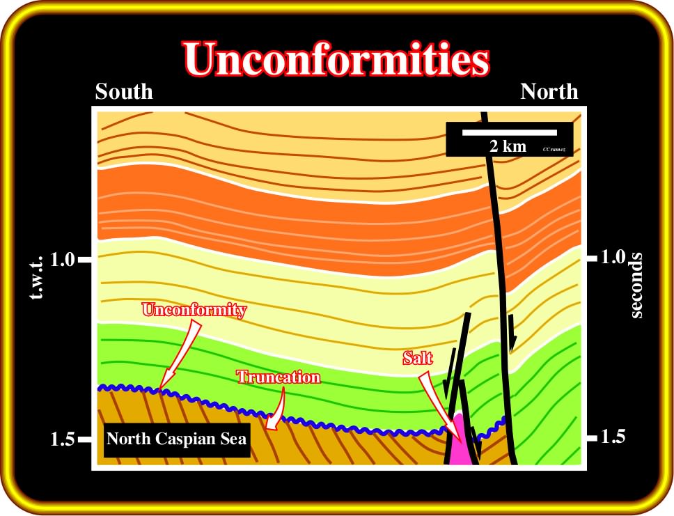
Plate 196 - As we will later (volume III), unconformities are mainly eustatically induced. However, they can be tectonically enhanced (halokinesis and shalokinesis included). In such a hypothesis, the underlying associated reflection terminations are truncations and the unconformity is often labeled an angular unconformity. On this tentative interpretation, it is quite evident that the picked unconformity (blue) was tectonically enhanced. In fact, in the North Caspian Sea, and particularly in the area of the Kashagan oil field, halokinesis is paramount. The major geologic role of Permian salt (Kungurian salt) flowage was the deformation and uplift of Triassic sediments, which were partially eroded (truncation) before being covered by Jurassic marine sediments.
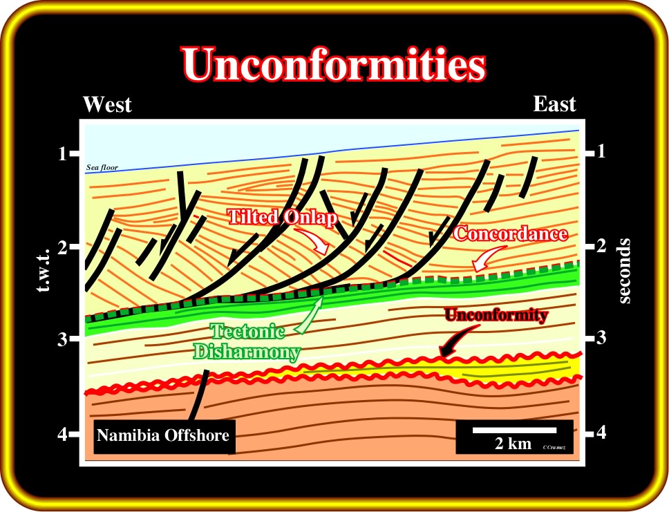
Plate 197- As depicted on this tentative interpretation, geoscientists must differentiate tectonic disharmonies from unconformities (erosional surfaces). Tectonic disharmonies, as the one depicted above, are décollement surfaces bounding two sedimentary intervals with quite different deformation styles. There is not significant erosion associated with tectonic disharmonies. On the contrary, as stated previously, erosion is a distinguishing characteristic of unconformities. Erosion is mainly subaerial. Submarine erosion is generally localized on the upper slope and associated with gravity currents.
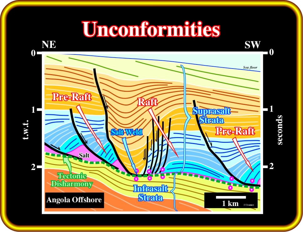
Plate 198 - In salt basins, the evacuation of salt creates, often, significant tectonic disharmonies. On this tentative interpretation of a seismic line of the Kwanza basin (Angola) a salt induced tectonic disharmony is obvious. Such a disharmony can be recognized on almost all seismic lines of the Kwanza basin. As depicted, due to salt flowage, suprasalt strata is quite deformed, while infrasalt strata is almost undeformed. The reflection terminations of the suprasalt strata are unoriginal. They look like downlaps but actually they are tilted onlaps. It is important to notice that there is not erosion between the infra and suprasalt strata. Such interface cannot be considered as an unconformity (relative sea level fall). Salt welds were developed where salt expulsion was complete.
to continue press![]()
![]()