
Diachronous surfaces are continuous boundaries crossing strata or seismic reflectors. Diachronous surface examples are:
- Fluid Contacts ;
- Permafrost ;
- Gas Hydrate Layer ;
- Low Angle Fault Trace ;
- Low Angle Igneous Dike ;
- Deep Desert Weathering Surface ;
- Karstic Solution Base Level.
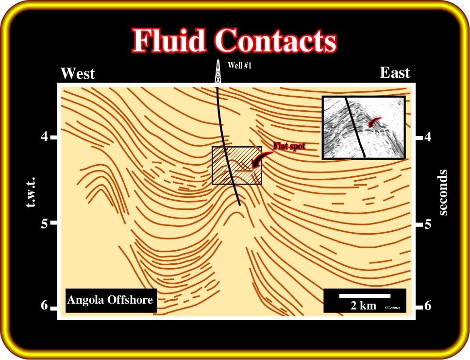
Plate 245- On this tentative interpretation of a seismic line from Angola northern deepwater, a diachronic reflection (not a time line) is easily recognized at around 4.3 seconds. This anomalous reflection was interpreted as a flat spot, i.e., as the reflection induced by the interface hydrocarbons/water. The location of the well was mainly based on such interpretation. Successfully, such a hypothesis was corroborated by drilling, which proved a significant oil column. Note that in spite of the oil discovery, in epistemological terms, geoscientists did not increase their knowledge since the advanced hypothesis was not refuted.
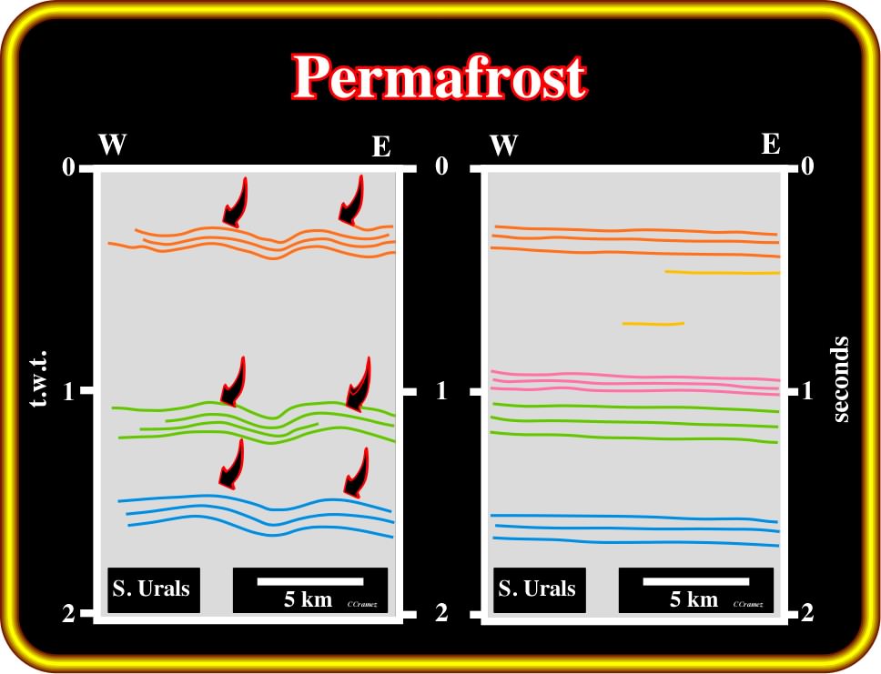
Plate 246 - Comparing these both tentative interpretation (south Urals) it is easy to understand that permafrost (permanently frozen soil) induced diachronous surfaces (see also volume I). On the left, (permafrost effect not corrected), the reflectors do not correspond to chronostratigraphic lines. They correspond to seismic pitfalls. On the right line, on contrary, the reflectors correspond to real chronostratigraphic lines. The permafrost effect (ice ground) effect was corrected.
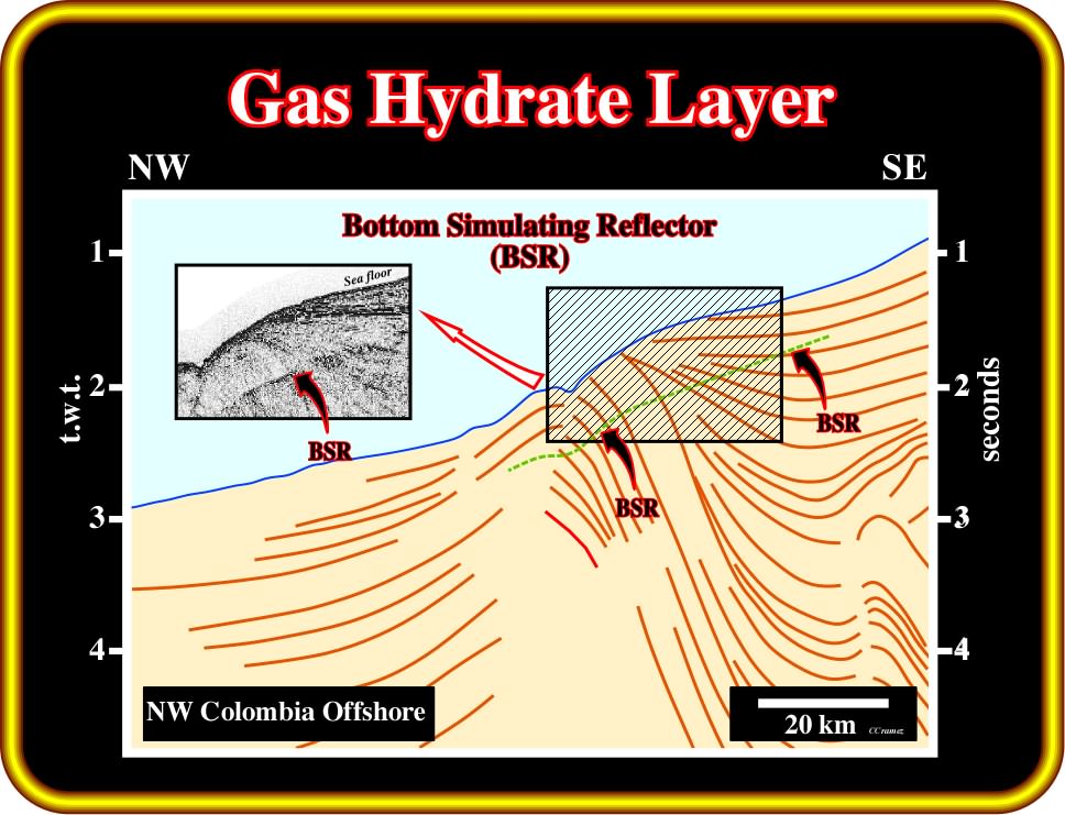
Plate 247 - On this line tentative interpretation (Colombia offshore) a diachronous seismic reflector is easily recognized roughly 0.5 seconds below sea floor. The bottom simulating reflector (BSR) is caused mainly by gas bubbles at the base of the stability zone, which accordingly cannot act as a seal because the porosity is more than 95% filled by water. Gas hydrate stability zone (GHSZ) occurs in oceanic sediments over the first few hundred meters below the seabed. In this zone, any methane from organic material, including any seepages from below, is converted into solid hydrate, and is locked, in place, in the sediments. The origin of methane is poorly understood. Even its biogenic origin is being challenged.
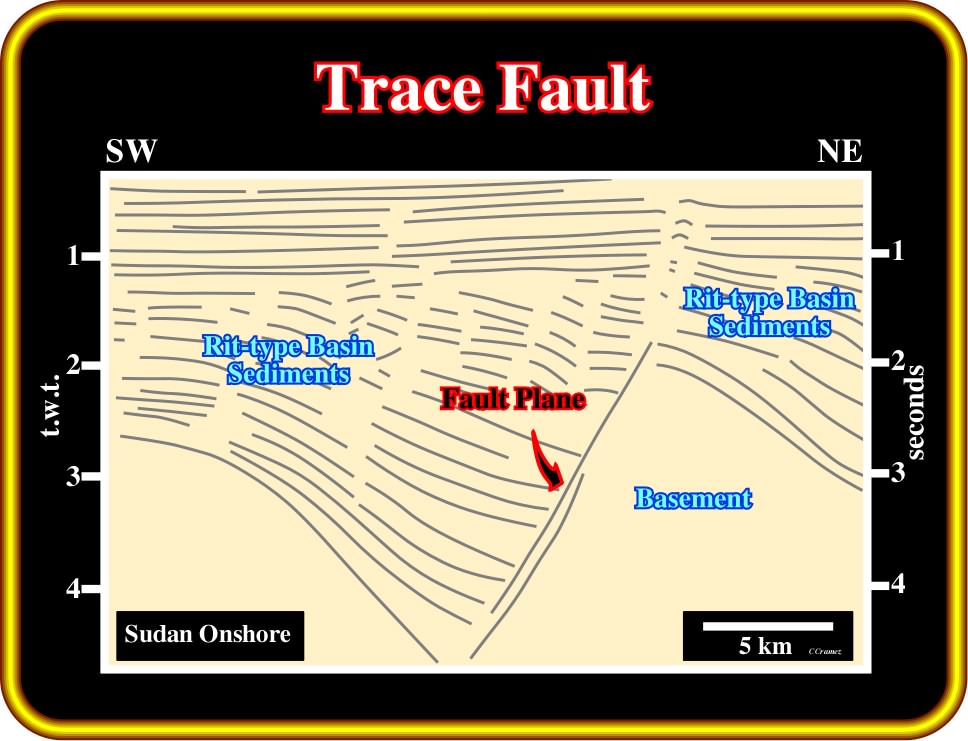
Plate 248- Generally, fault planes do not have seismic reflectors associated. However, there are three main exceptions that all seismic interpreters know: (i) when the fault put sediments and basement in juxtaposition, (ii) when the fault plane is filled by salt and (iii) when the fault plane is injected by volcanic material. In this tentative interpretation, the diachronous reflector is associated with a fault plane, which puts rift-type basin sediments and a Precambrian basin (granite-gneiss) in juxtaposition. This tentative interpretation of a seismic line from Sudan onshore, depicts the northeastern flank of the Unity giant oil field. The discovery well was located on the left end part of the line.
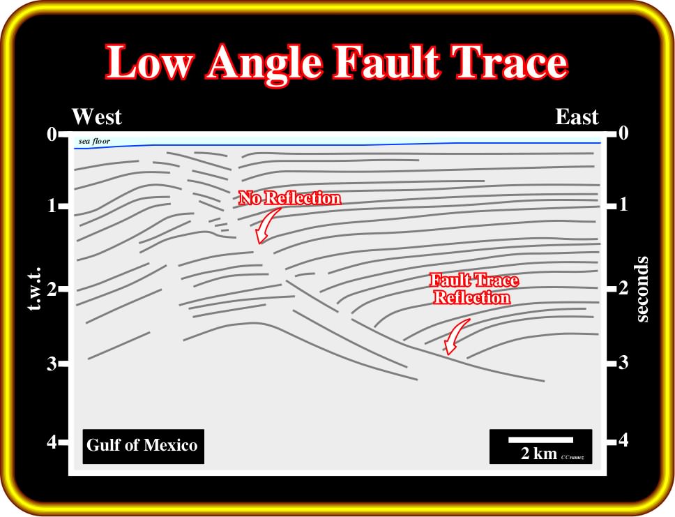
Plate 249- On this tentative interpretation of a seismic line from the Gulf of Mexico, a listric growth fault, that is to say, a fault contemporaneous with the sedimentation flattens in depth. It clearly shows that a diachronous seismic reflection is created in the lower segment of the fault plane, where it has a high hade (angle of inclination of a fault plane measured relative to the vertical). In the upper segment with a low hade (higher angle) there is no reflection associated with the fault plane. The interpretation of such a feature is directly associated with the seismic reflection method as saw previously.
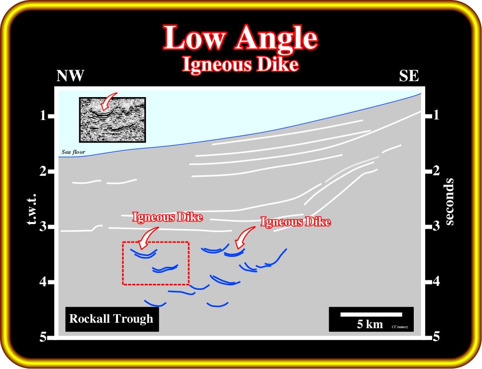
Plate 250- Igneous dykes are quite frequent in the North Atlantic, particularly in the Rockall Trough. In this tentative interpretation of a seismic line of this area, diachronous igneous dykes can easily be recognized not only by their anomalous amplitude but by their diachronous geometry. Often, particularly when the frequency of such a igneous dykes is not so high, as in Barents Sea, few of them were erroneously interpreted as incised valley or canyons.
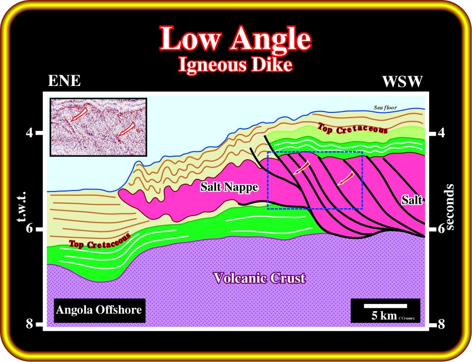
Plate 251- In the deep-water Angola, it is well known that the salt layer was thickened by thrusting, i.e., by lateral stacking of successive gravity induced thrust faults, which give an apparent outbuilding of the salt layer. Diachronous landward high dipping reflections, as depicted on the right part of this tentative interpretation, have been associated with the fault planes. Recent exploration wells, particularly in offshore Morocco suggest that such fault planes are filled by volcanic material, which seems to be scraped from the volcanic floor over which displacement took place.
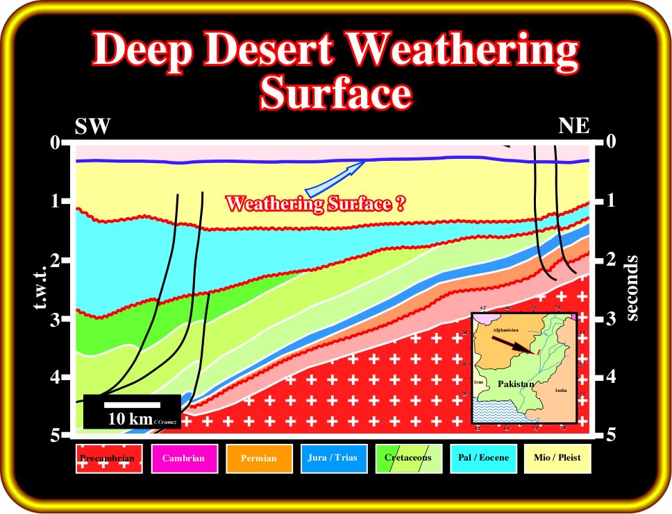
Plate 252- On this tentative interpretation of a seismic line of Pakistan onshore, probably the diachronous horizon blue correspond to a deep desert weathering surface. In other words, the uppermost interval is interpreted as a weathering interval. In fact, on the original seismic line, the internal configuration of this interval is reflection free, which does not falsify the assumed weathering conjecture.
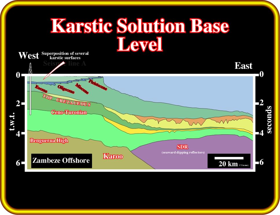
Plate 253- On this tentative interpretation of a regional seismic line of offshore Mozambique, it is easy to recognize a transgressive Cretaceous interval overlain by a lower Cretaceous regression interval, which was fossilized by a regressive Tertiary interval. The limit between the backstepping geometry (thickening landward) and the forestepping or progradational geometry (thickening seaward before becoming condensate) corresponds a major downlap surface (Cenomano-Turonian). The deposition of the progradational Tertiary interval was mainly induced by eustatism (the horizons of the shelf are subhorizontal), which strongly favored (climate also) the deposition of carbonate platforms, in which several karstic surface developed. This conjecture is corroborated by the results of the well. Due to the absence a significant seaward tilting the horizons associated with the karstic surfaces are, more or less parallel, to the chronostratigraphic horizons.
to continue press![]()
![]()