
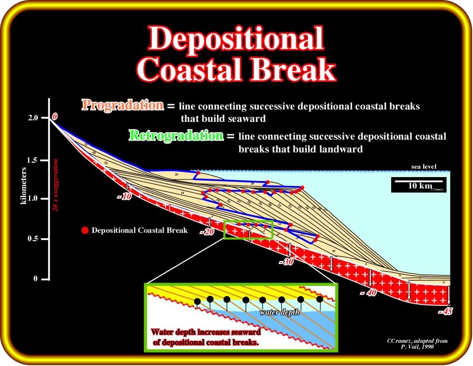
Plate 351 - On this mathematical model, the depositional coastal (sharp break in the dip of each chronostratigraphic line) is coincident with the shelf break except during the transgressive episodes (time lines 12, 13, 14 and 28, 29), during which the basin has a platform (shelf). Landward of the depositional coastal break the paleowater depth is zero. All space available (accommodation) is filled. Seaward of the depositional coastal break, the space available for the sediments is only partially filled. A water depth is created. The water depth can be easily calculated by taking the depositional coastal break as having zero water depth.
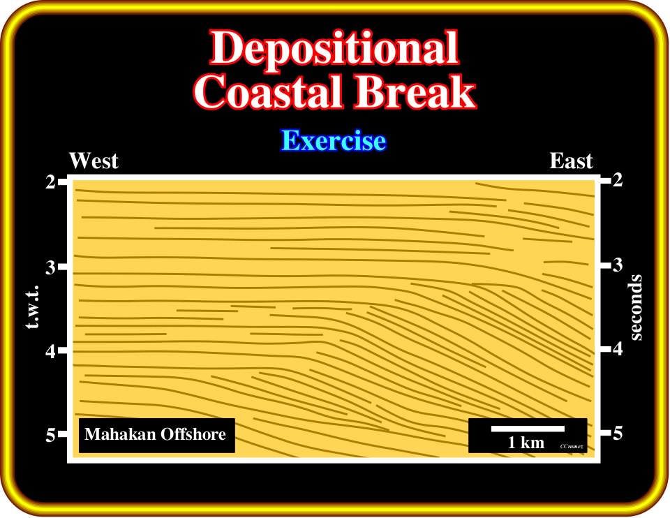
Plate 352- On this first step tentative interpretation and in spite of the low quality of tho original seismic line, in which a regressive interval is predominant, try to pick the successive positions of the depositional coastal break (roughly coincident with the shelf break). Then, indicate the progradational and retrogradation displacements of the depositional coastal break. Finally, using these displacements propose the most likely location of the major unconformities. If you have problems, you can find a tentative solution on Plate 353.
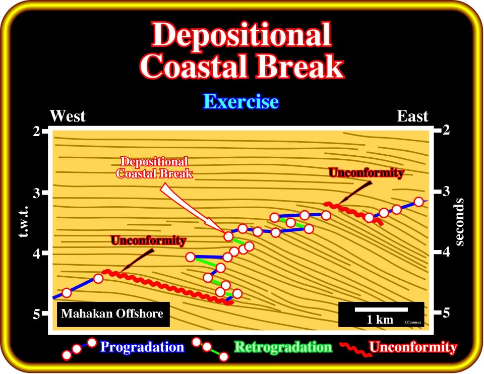
Plate 353 - Taking into account the seismic resolution, the most likely successive positions of the depositional coastal break are indicated by the red dots. Progradation happens when the depositional coastal breaks build seaward (blue line). When they are displaced landward, retrogradation takes place. The more likely locations of the major unconformities are emphasized by downward and basinward displacements of the depositional coastal breaks.
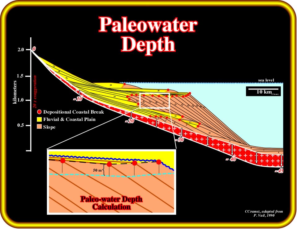
Plate 354 - As said previously, the paleowater depth can be easy calculated. Assuming that the paleowater depth at the depositional coastal break is zero, at a given point seaward of the depositional coastal break, the depth of such a point, when measured perpendicularly to the coastal plain associated with the depositional coastal break, gives the paleowater depth. The same can be done on seismic lines.
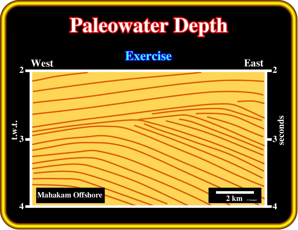
Plate 355 - In this first step tentative interpretation of a seismic line of offshore Indonesia, assuming that at this depth, the basin has no platform, start to pick the most likely position of the depositional coastal breaks, which are roughly coincident with the shelf break. Then, pick the area with 0.2 and 0.4 seconds (t.w.t.) of paleowater depth. On the next Plate, we will find a tentative solution.
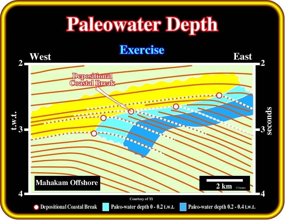
Plate 356- The most likely solution of the previous exercise is presented above. For determining the paleowater depth, you just need to find the depositional coastal break, where the paleowater depth is zero, and then measure the time depth perpendicular to the coastal plain limited by the coastal break.
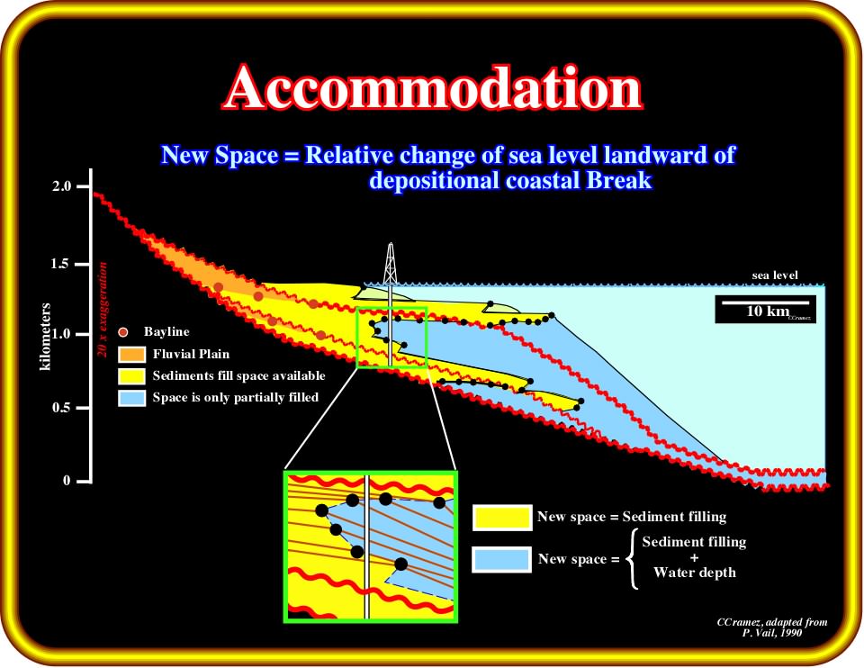
Plate 357 - Whenever there is a relative sea level rise (RSLR), the available space for the sediments, i.e., the accommodation increases. Landward of the depositional coastal break (or shelf break, when they are coincident), all new space is filled by sediments (if the terrigeneous influx is enough). Contrariwise, seaward of the depositional coastal break, only part of the new space is filled. Seaward of the depositional coastal break, the new space is equal to the sediment deposits plus the water depth. Knowing the thickness of the sediments deposited seaward of the coastal break and the water depth, which can be reckoned by micropaleontologic studies, it is possible to estimate the relative sea level change. Landward of the depositional coastal break, there is no major problems. The sediment thickness gives the space available, which corresponds to the relative sea level change.
New Space = Accommodation
Variation in sedimentary accommodation reflects the space made available for sediment accumulation through a combination of subsidence and sea level rise or fall. Whether this space is entirely filled depends on the rate of sediment supply to the basin. The key to sequential stratigraphy interpretation of well data, for instance, lies on the application of the accommodation concept to the interpretation of depositional environments. P. Vail identifies the variations in sedimentary accommodation in several steps :
1) Locate the marine shale wedge
In a siliciclastic section the marine shale wedge typically occurs on the shelf, where it is overlain and underlain by coarser sediments and extends laterally into the slope and basin. In a carbonate section, this wedge may be shales, marls or calcareous muds, and it is typically overlain by coarser clastic carbonates or by evaporites and underlain by transgressive carbonates.
2) Locate (shelf) an overall fining/thinning upward pattern at the base of the marine shale wedge
In siliciclastics, this often form a bell shaped log pattern and reflect the retrogradation of successive parasequences as rapid sea level rise forces the shoreline away from the basin and across the shelf. In carbonates, these variations may be less visible on logs and may require sample and core studies to recognize the fining upward pattern and the increase in depositional water depth.
3) Locate (shelf) the overall coarsening/thickening upward patterns at the top of the marine shale wedge
In siliciclastic deposits, this often forms a funnel shaped pattern at the top of the marine shale wedge, representing progressive progradation of delta-front sands, followed by deltaic and fluvial sand-shale sections representing decreasingly marine conditions. Similar shallowing upwards facies patterns can be observed in carbonates through core and sample studies, aided by biostratigraphy.
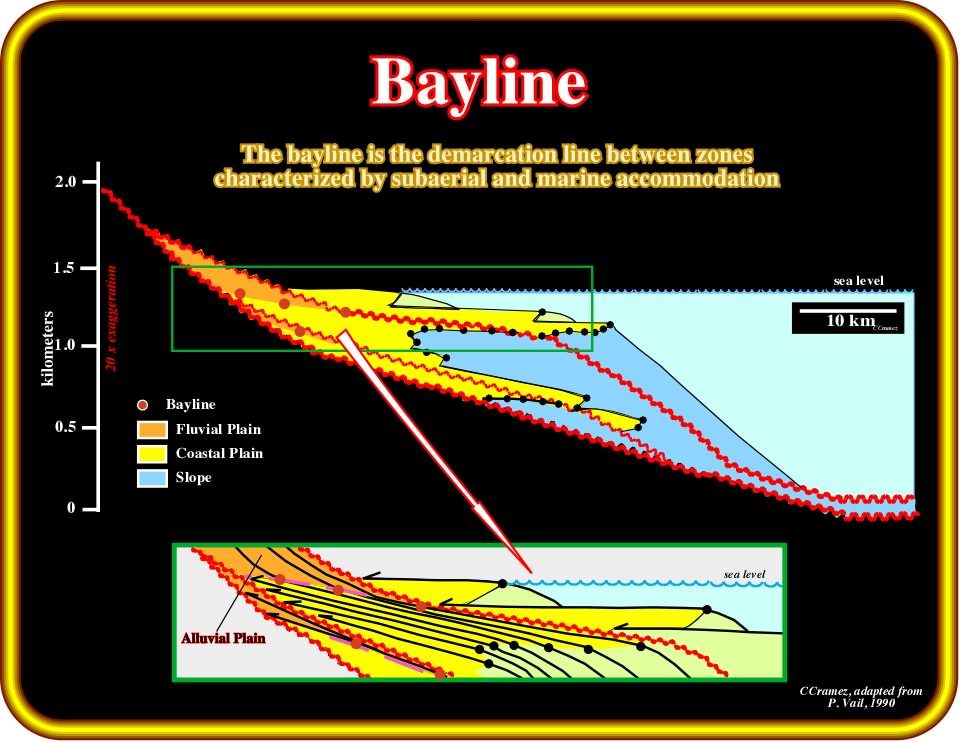
Plate 358 - In the majority of chronostratigraphic lines (depositional surfaces), there are three principal breaks: (i) bayline, limit between fluvial and coastal sediments ; (ii) depositional coastal break, which separates coastal and marine sediments and (iii) shelf break, which limits shallow marine sediments (< 200 meters) from deep marine sediments (> 200 meters). As indicated above the bayline, which is quite difficult to recognize on seismic data, separates the alluvial plain from the coastal plain. The change in dip associated with a bayline is so small that, very often, it is under seismic resolution. Subsequently, the next examples are quite speculative.
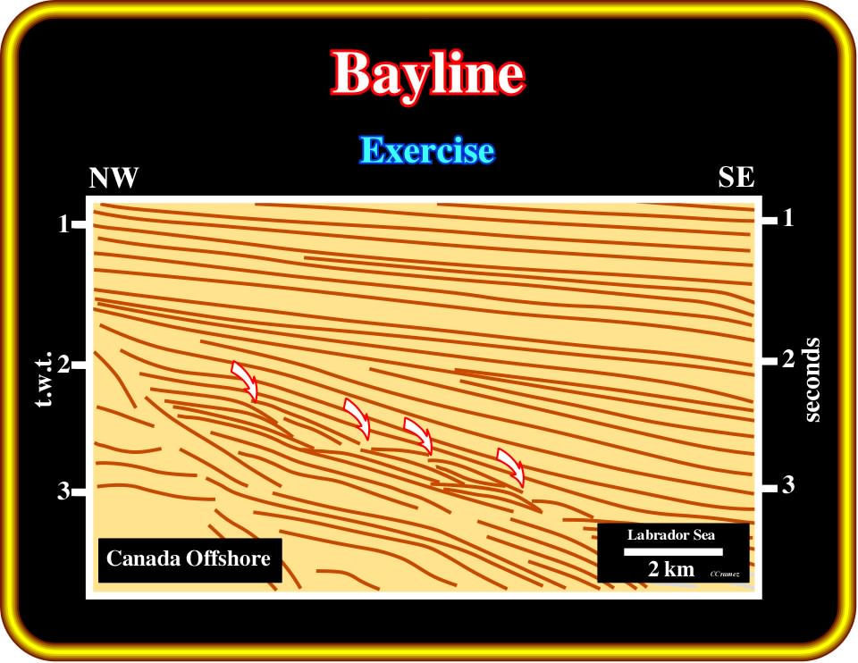
Plate 359 Using this first step tentative interpretation of a seismic line of offshore Labrador (Canada), located the successive positions of the depositional coastal break (which here does no coincide with the shelf break), try to pick the main unconformities and locate the bay line. Compare your interpretation with the tentative solution proposed on next plate. Criticize both solutions.
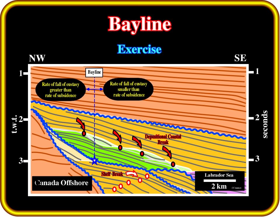
Plate 360- Landward of the bayline, which separates the alluvial plain from the costal plain, the rate of fall of eustasy is greater than the rate of subsidence. On the contrary, seaward of the bayline, the rate of fall of eustasy is smaller than the rate of subsidence. The concept of a bayline (Posamentier, 1988), implies that it, rather than the shoreline, is the base-level point to which stream profiles are adjusted to. Also, it was assumed that a relative sea level rise or fall displaces the equilibrium point (point on the continental margin at which subsidence and sea-level change are in balance) landward or seaward. All these conjectures should be criticized. The tectonic activity, sediment supply and local relative sea level changes must be take into account.
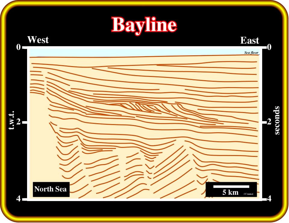
Plate 361 - Assuming that there is a bayline on this first step tentative interpretation of a seismic line from North Sea, locate the most likely location, take into account that it is, according to Posamentier (1988), the demarcation line between fluvial and paralic/delta plain environments. Note that the concept of bayline has been severely criticized (Miall, 1977), particularly the conjecture that it corresponds to the base-level point to which streams profiles are adjusted.
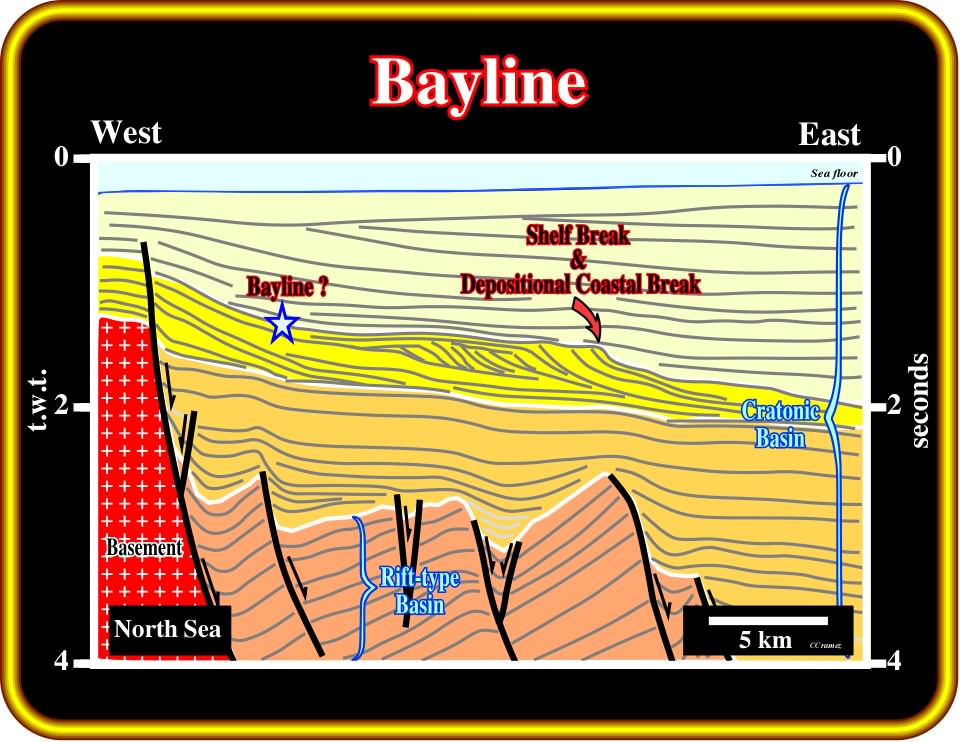
Plate 362 - I really don’t think there is a bayline on this line. However, taking into account that it corresponds to most landward break of a depositional surface, the most likely location is underlined by the star, since the upper unconformity of the regressive interval (in yellow) shows two sharp dip changes. On the other hand, as in a progradational interval, the depositional coastal break and the shelf break are coincident, there is a slight chance that the landward break underlines the bayline.
to continue press![]()
![]()