
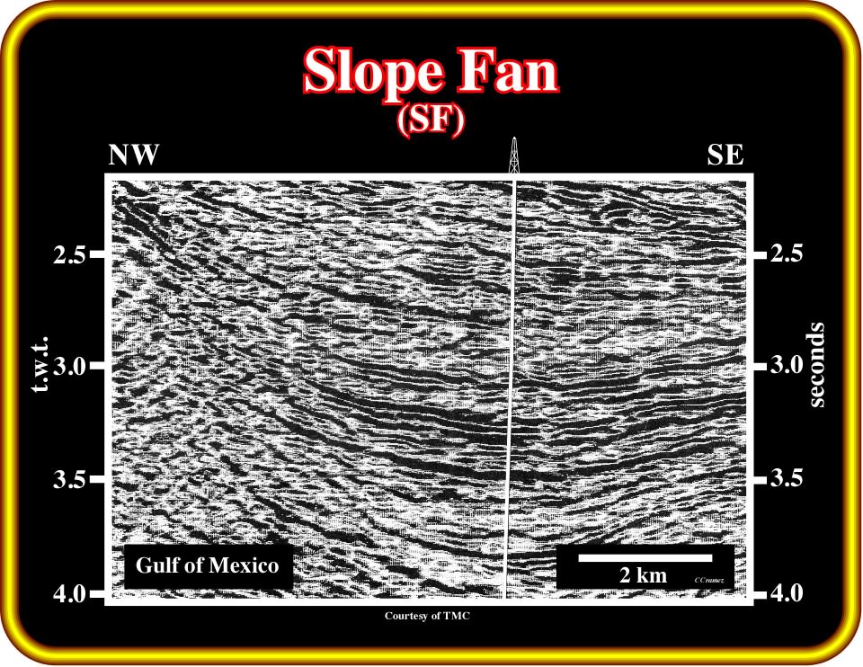
Plate 403 - In the Gulf of Mexico, uplifts, induced by diapiric salt structures, associated with the autochthonous and allochthonous salt layers, induce, often, gravity slides into the minibasins that, in certain cases, can be recognized in the lowstand systems tract. After proposing a sequential interpretation of this close-up a seismic line from the Gulf, try to locate the slump blocks. If you have problems picking the most likely sequence boundary, take a look at the next plate (Plate 404).
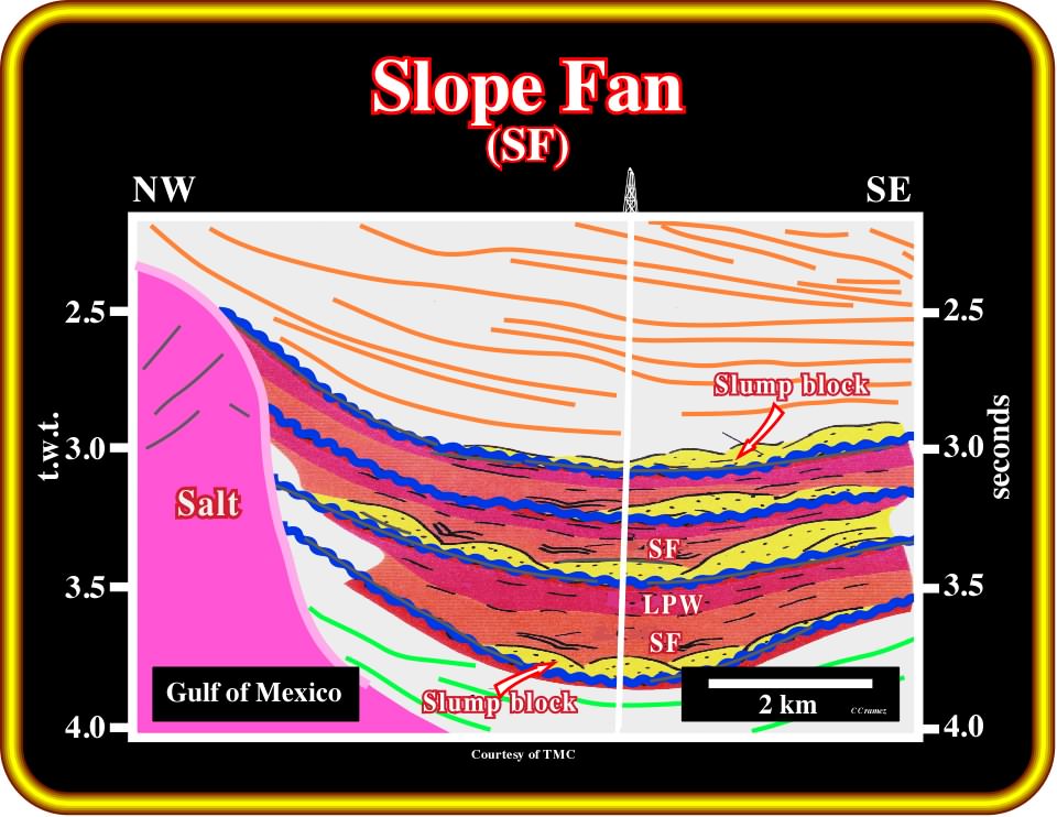
Plate 404- The previous close-up (Plate 403) can be tentatively interpreted as illustrated. The sequence cycle boundaries are mainly underlain by the bottom of the mounded slide blocks. Each sequence cycle is composed by a slope fan and a lowstand prograding wedge. Due to the local geological conditions imposed by salt tectonics, i.e., in a salt expulsion basin context, the slumping blocks are attached to slope fans rather than basin floor fans.
Plate 405 - This seismic line, from the Gulf of Mexico, illustrates a small oil discovery, in which the migration/entrapment petroleum subsystem is associated with the middle member of a lowstand systems tract, i.e., a slope fan. The trapping mechanism is non-structural, but the structural component is quite important. Making a sequential interpretation of this line it is relatively easy to recognize the location of the field, as well as the depositional system of the reservoir-rocks. Propose the most likely location of the field and the geometry of the reservoir-rocks. Concentrate the interpretation between 3 and 4 seconds depth.
Plate 406 - This seismic close-up illustrates the trapping mechanism and geometry of the potential reservoirs of the field that you should recognize on the previous seismic line (Plate 405). As you already noticed, on this line, the blue lines underlay the main seismic packages composing the field. Assuming that such boundaries are well picked, can you overprint a geological interpretation indicating the most likely location of the reservoir-rocks? Describe them and explain, in terms of hydrocarbon saturation, the amplitude anomalies.
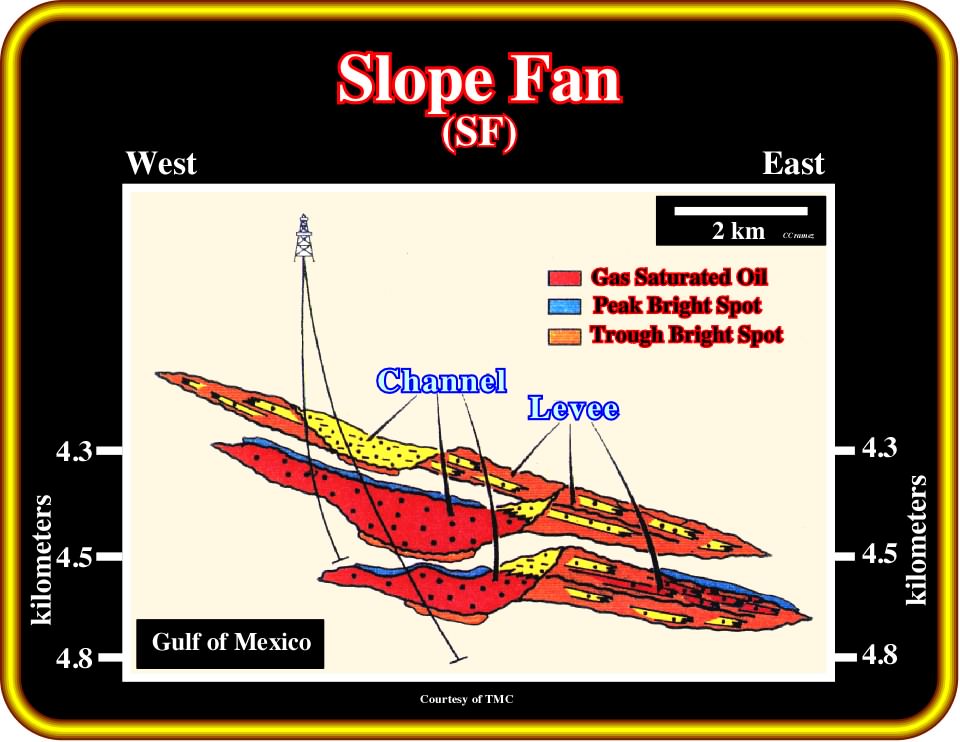
Plate 407- This depth sketch is the most likely geological interpretation of the previous close-up (Plate 406), in which a hydrocarbon accumulation was found. The hydrocarbon bearing reservoirs are mainly those filling the original depression between the overbank deposits. However, it cannot be excluded that some thin sandstone layers of the overbank deposits are also saturated by a certain amount of hydrocarbons. The peaks of the bright spots emphasize the top of the pools, while the troughs underline the overbank shales.
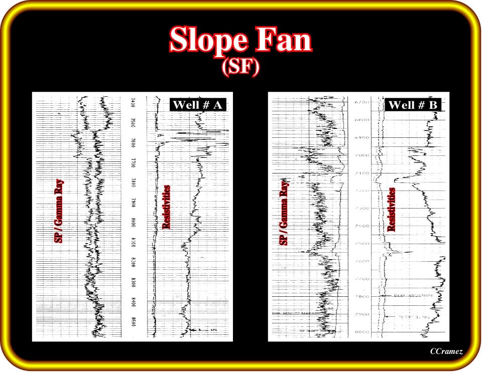
Plate 408 - These electrical logs are those run in two wells of the field recognized on the previous plates. Make the sequential interpretation, in terms of systems tracts, i.e., at the sequence cycle hierarchy of these electrical logs. Then, taking into account your log interpretation, check the seismic interpretation that you proposed previously and make the necessary changes, if changes are necessary.
On this member P. Vail (1989) wrote:
1) As eustatic sea level passes the lowstand position begins to rise slowly. This effect, combined with continued basin subsidence begins to move the relative position of the sea level upward toward the old shelf-slope break ;
2) Rivers deposit shelf sediments beyond the old shelf break and bay, delta and shoreface sands begin to accumulate on the upper topographic slope as relative sea level rises ;
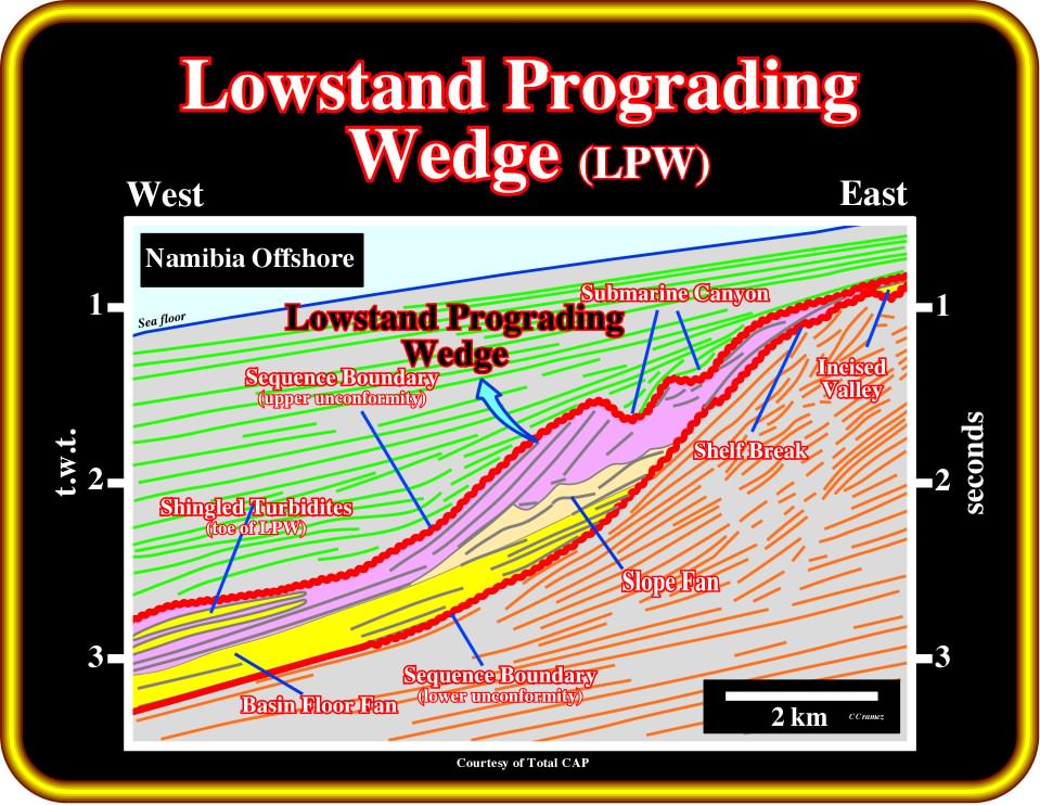
Plate 409 - A lowstand prograding wedge, with shingled turbidites at the toe of the progradations, can be easily recognized on this line from offshore Namibia. The associated stratigraphic sequence-cycle is incomplete. The transgressive and highstand systems tracts are missing. In such conditions, in the proximal area, the top of the lowstand prograding wedge is limited by an unconformity, underlain by submarine canyons, while, in the distal area, it is limited by a downdip correlable paraconformity.
3) These units prograde laterally into the basin, resulting in deposits in bathyal to abyssal water depths composed predominantly of shales with few thin turbidite sands ;
4) If the prograding complex receives a large volume of sand supply, this system may become overloaded and any minor short-term lowstand results in a basin floor turbidite sand at the shingled toe of the prograding complex ;
5) A thick series of shallow marine deltaic and shoreface sands may stack vertically in the updip portion of the prograding complex. Subsequent differential compaction may result in a closed compaction high over these sands ;
6) Because the shelfward lateral seal is poor, these shallow marine sediments generally require structural closure to trap hydrocarbons ;
7) Prograding complex sediments typically infill any associated submarine canyons cut into the old shelf margin during the late stages of the prograding complex time. These sediments also infill the river valleys in the shelf ;
8) At the end of prograding complex time, eustatic sea level begins to rise rapidly and a major flooding event occurs, starting the transgressive systems tract ;
9) Sand at the top of the prograding complex and on the adjacent shelf are reworked by this marine invasion, which is typically followed by deposition of marine transgressive shales which provide a topseal for all lowstand system tract units.
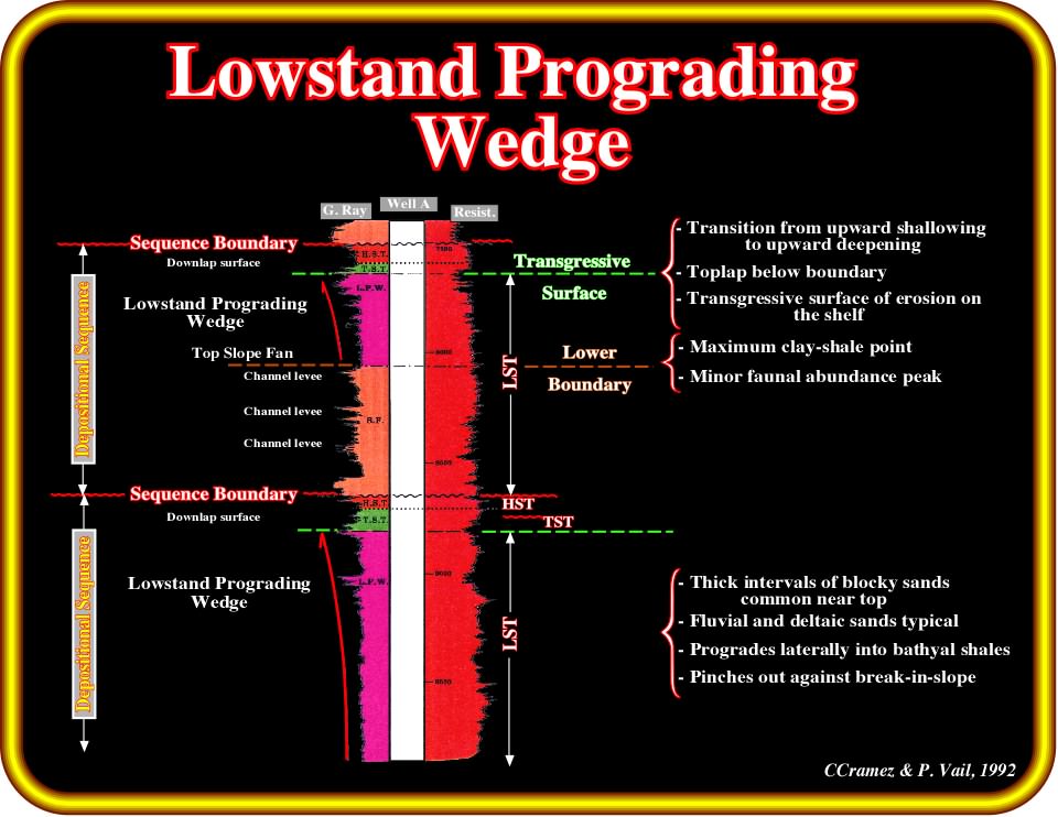
Plate 410 - The log patterns associated with lowstand prograding wedge are here depicted. Roughly speaking, one can say that they emphasize a coarsening and thickening stratigraphic interval. In sand-shale facies, the sand layers are thicker and coarsening toward the top of the lowstand prograding wedge. In terms of relative sea level, one can say that the sand layers are thicker and coarser as the sea level rises in acceleration. The top of the lowstand wedge is defined by a flood surface produced when the rate of sea level rise reaches its maximum
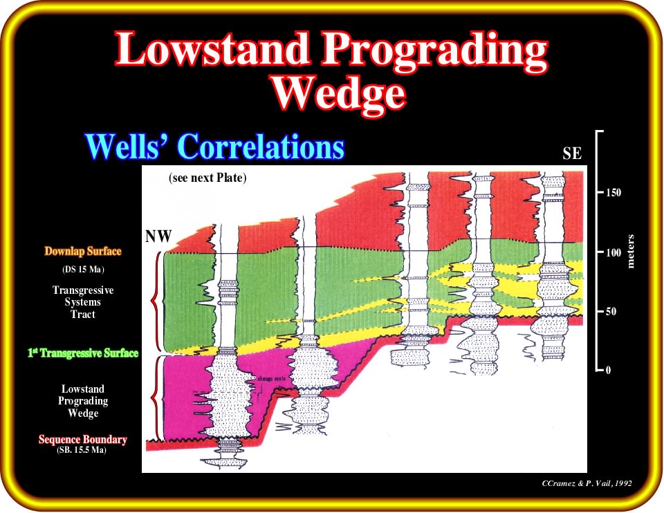
Plate 411 - This figure illustrates the sequential stratigraphic correlation between five onshore wells (Venezuela). The 15.5 Ma sequence-cycle boundary is easily recognized in the majority of the wells. Two of these wells penetrated the lowstand prograding wedge seaward of the shelf break at the 15.5 Ma level. The lowstand prograding wedge (LPW) is overlain by a transgressive systems tract that landward of the 15,5 Ma shelf break overlies directly the 15.5 Ma sequence boundary. Landward of the 15.5 Ma shelf break there is not LPW. In terms of hydrocarbon exploration, the sandstone horizons of the LPW are hydrocarbon bearing as well as the landward thickening transgressive sandstones. These correlations strongly suggest the trap is fundamentally non-structural. Such hypothesis is corroborated by the seismic lines crossing the field (see Plate 412).
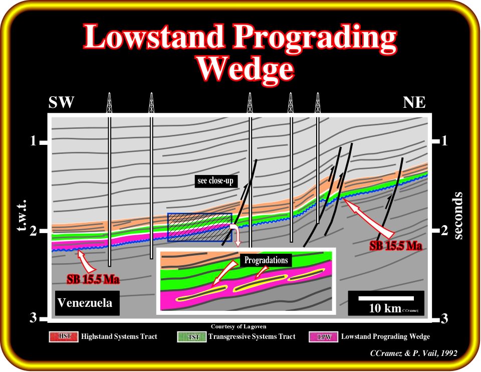
Plate 412 - This tentative interpretation of a seismic line shows the location of the five onshore wells illustrated on the previous plate. The proposed interpretation suggests that the limit shelf-slope is enhanced by a normal fault, which later was reactivated as reverse. Similarly, it indicates the absence of the lowstand prograding wedge seaward of the 15.5 Ma shelf break. In spite of a strong structural component, the trapping is clearly non-structural. There is no four-way dip closure. The forestepping geometry of lowstand chronostratigraphic lines, as suggested by the interpreted close-up, corroborated the sequential interpretation proposed previously plate, i.e., seaward of the 15.5 Ma shelf break, the lowstand sediments belong to a lowstand prograding wedge.
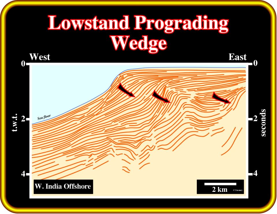
Plate 413 - Theoretically, divergent margins, Atlantic-type or not, have quite well developed lowstand prograding wedges, as illustrated on this provisional tentative interpretation of a regional line from offshore West India. Above the break-up unconformity (do you see where it is located?) and particularly above the major post-Pangea downlap surface (do you see where it is located?), lowstand systems tracts are predominant, particularly lowstand prograding wedges. See final tentative interpretation on the next plate (Plate 414).
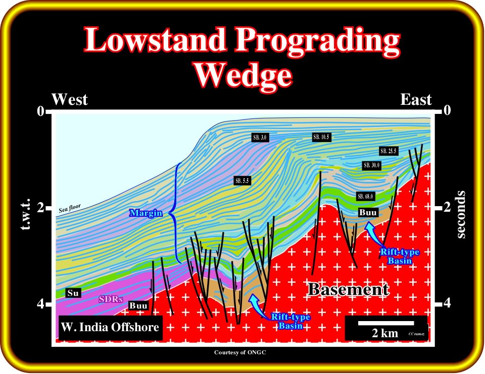
Plate 414- On this tentative interpretation, the breakup unconformity (BUU), induced by the break-up of the Pangea lithosphere, is clearly recognized below the subaerial lava flows (SDRs). The major Meso-Cenozoic downlap surface corresponds roughly to the top of the green interval. It separates the forestepping (above) from the backstepping (below) geometry. LPWs are paramount within the regressive phase of the post-Pangea continental encroachment cycle, particularly after the sequence boundary 25.5 Ma (at least on this line).
Exploration Applications:
1) Reservoir ;
- Variable ; Stacked fluvial, deltaic and shoreface ;
- Variable continuity ;2) Migration ;
- Probably depends on fault conduits from deeper source ;
- Possible downward migration from TST ;3) Source ;
- Deeper beds or TST source at top ;
4) Trap ;
- Typically structural ;
- Possible compaction closure ;5) Seal ;
- Good TST seal ;
- Lateral seal may be poor.
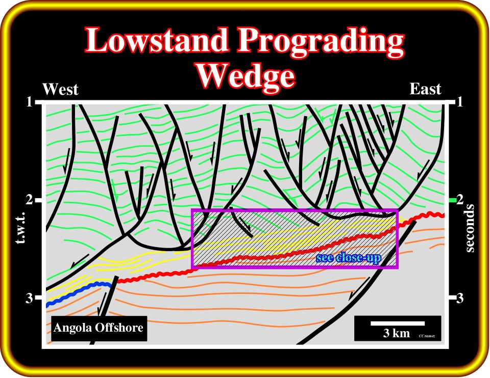
Plate 415- Under certain conditions, the forestepping geometry of the lowstand prograding wedges is not so evident as previously illustrated. The evidence of the progradational geometry depends on the geological setting of the lowstand systems tract. In deep-water and growth-fault settings, the forestepping geometry of the lowstand prograding wedge is obvious, as seen previously. However, as illustrated on this tentative interpretation (offshore Cabinda, Angola), in a ramp setting, the recognition of such a geometry, and thus the prograding wedge, requires a good knowledge of the regional geological context and a detailed and accurate picking of the chronostratigraphic lines as shown in next plate.
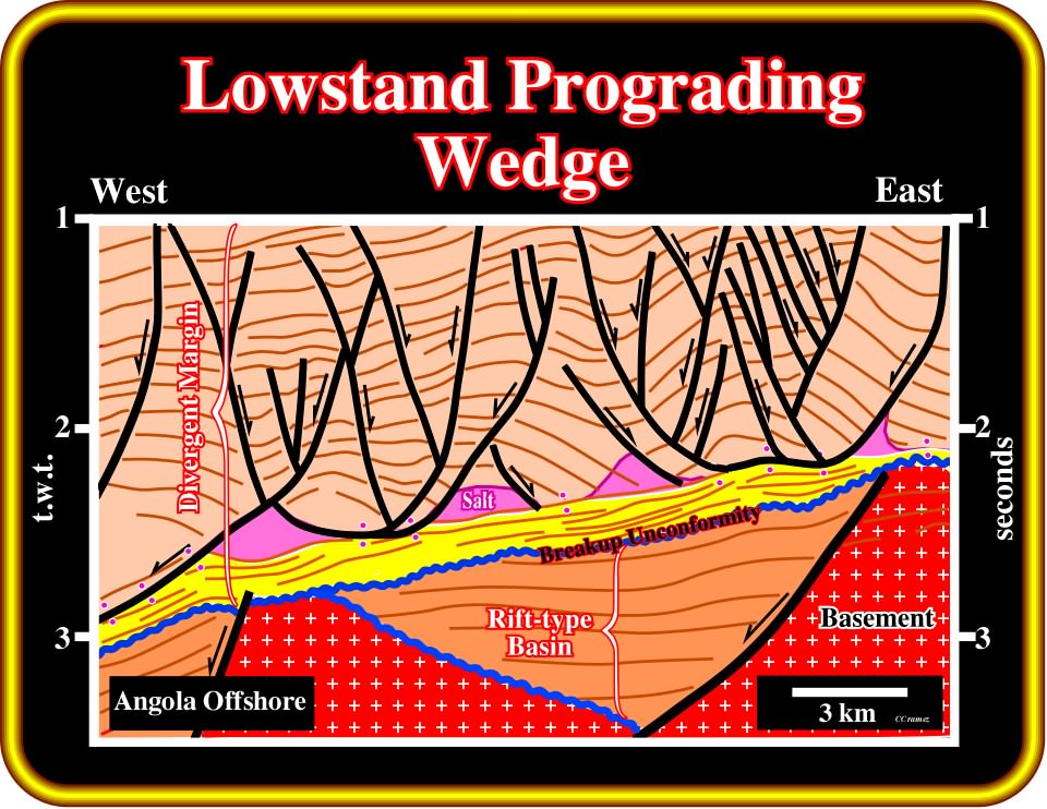
Plate 416- The regional context of the previous tentative interpretation is easily recognized. It corresponds to a divergent Atlantic-type margin developed above rift-type basins created during the rifting phase (lengthening of the Pangea lithosphere). After the breakup unconformity, the basal sediments of the margin (salt, in violet and infra-salt strata, in yellow) were deposited in lowstand geologic conditions under relative shallow water-depth, i.e., in a ramp geologic setting. If that is so, the forestepping geometry can only be easily recognized in anamorphosed seismic data, particularly in close-ups as illustrated next.
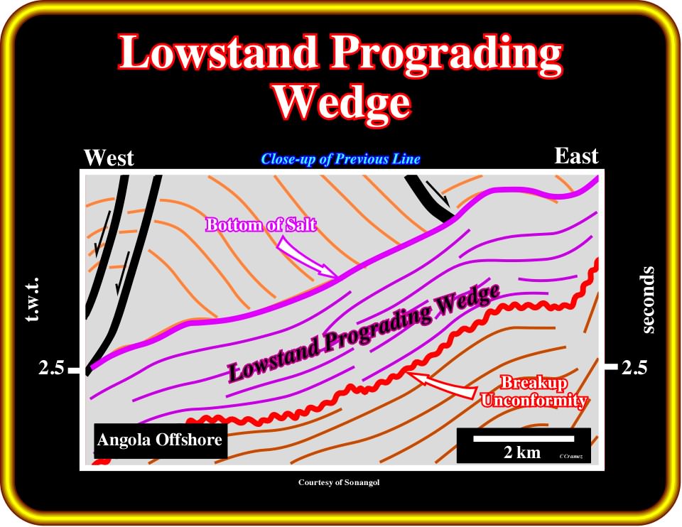
Plate 417- In this close-up of the tentative interpretation of a parallel seismic line, between the break-up unconformity and the bottom of salt (salt or salt weld), the chronostratigraphic lines have a progradational geometry. Their downdip terminations are downlaps as illustrated on the tentative interpretation proposed on the next plate.
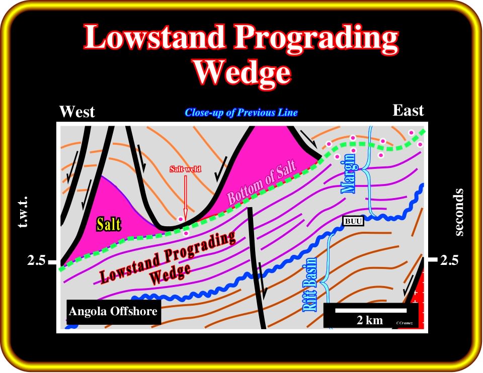
Plate 418 - This tentative interpretation (parallel line) suggests that the basal sandy interval of the margin corresponds to a lowstand prograding wedge, in which the depositional surfaces progressively fossilize, in downlap, the rift-type basin.
to continue press![]()
![]()