
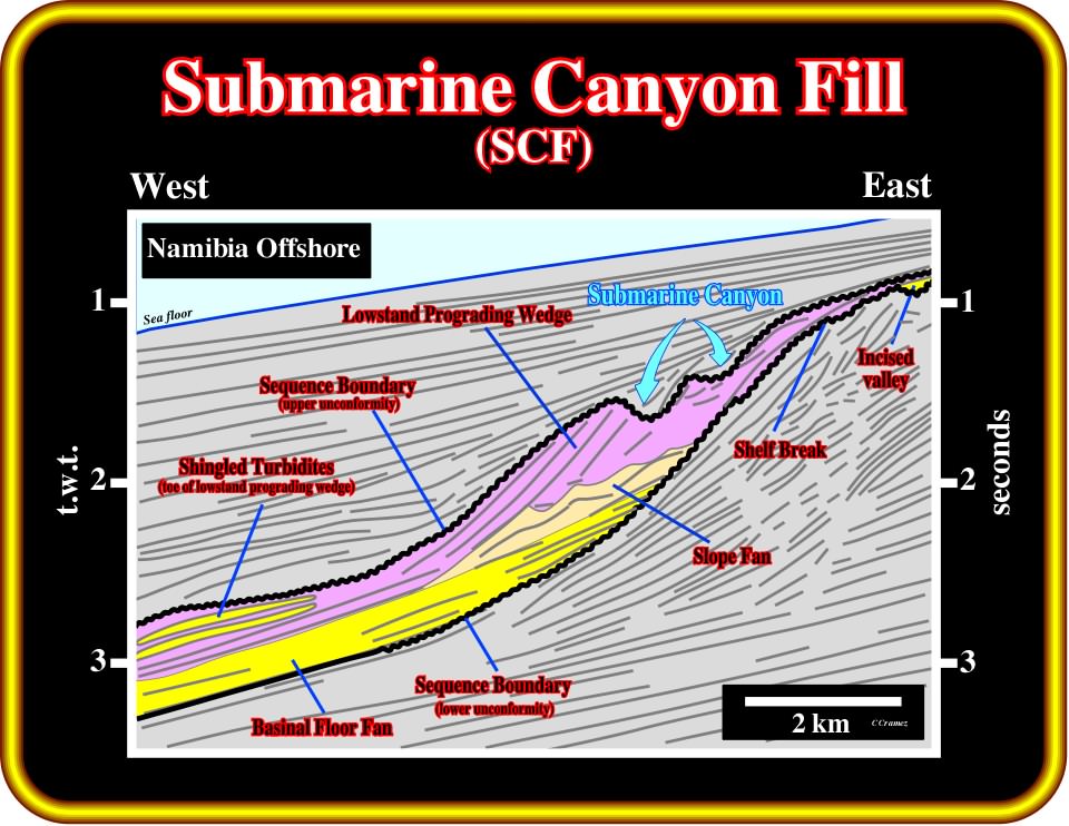
Plate 438- Submarine canyons (SC) and incised valleys (IV) are associated with the upper limit of lowstand systems tracts, which often corresponds to a sequence cycle boundary, as illustrated on this seismic line. In particular cases, they can be associated with the upper limit of transgressive systems tract, when the sequence cycle is complete. In the next plates, seismic examples and log patterns of these erosional features are illustrated.
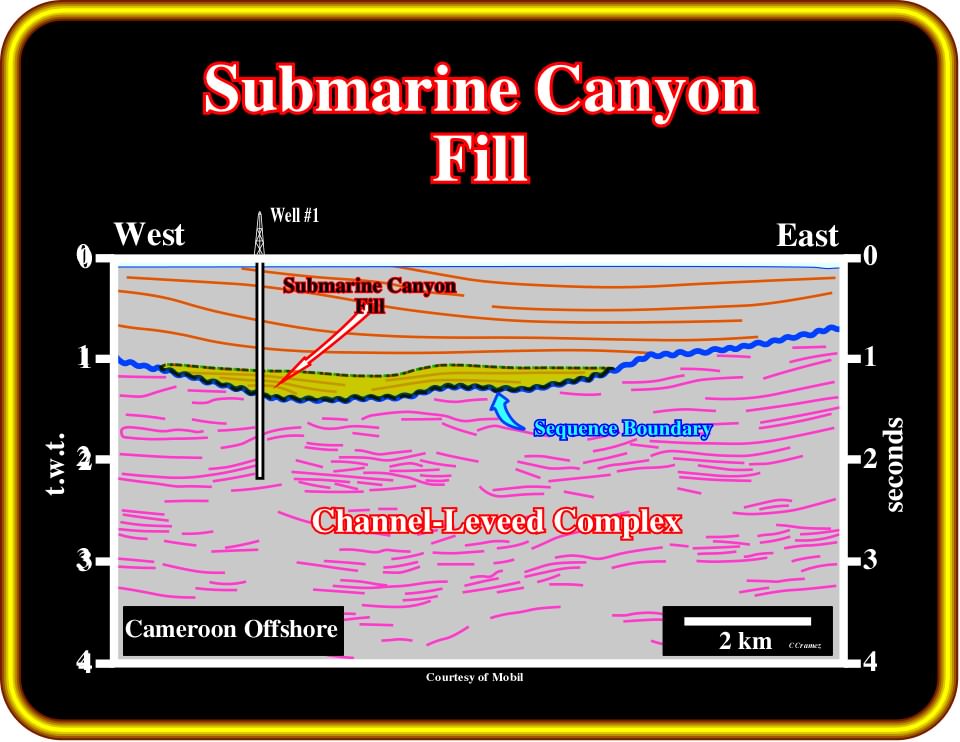
Plate 439- On this tentative interpretation of seismic line of the conventional offshore of Cameroon, large submarine canyons (SC) and canon fills (SCF) are associated with the Oligocene SB. 30 Ma sequence boundary. Several exploration wells, targeting deeper potential reservoirs, in slope fans, have found small non-economical oil and gas accumulations in the submarine canyon fills (SCF), as shown on this seismic line. Very often, explorationists have the bad habit of not differentiating submarine canyons (SC), i.e., bathymetric anomaly induced by erosion and submarine canyon fills (SCF), which correspond to the infilling of submarine canyons. The log patterns of such sedimentary infills are quite characteristic as illustrated on the next plate.
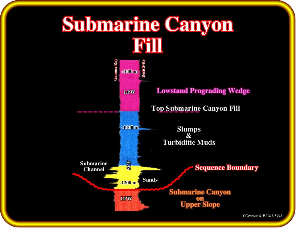
Plate 440 - The log patterns of well #1, located in the conventional offshore of Cameroon (see Plate 439), indicate at the bottom of a submarine canyon, the presence of relatively thin sandstone layers, some of which are saturated with hydrocarbons. The upper part of the submarine canyon fill is fundamentally shaly with abundant slumps and turbiditic muds. The bottom of the submarine canyon is marked by a sequence-cycle boundary, which is particularly well recognized in the dipmeter log.
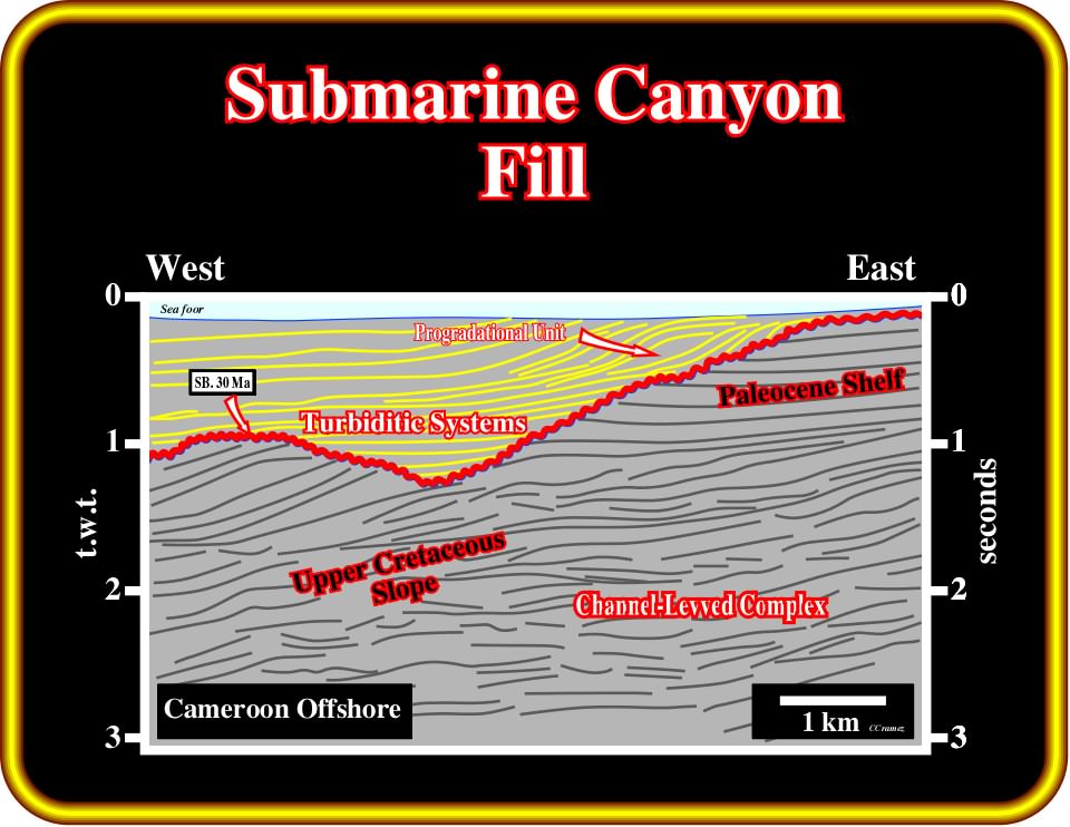
Plate 441- On this tentative interpretation, an Oligocene submarine canyon (see Plate 440) eroded the Paleocene platform (on the upper right part) and the Upper Cretaceous slope. The parallel internal configuration of the submarine canyon fill (at least on this line) suggests the presence of turbidite depositional systems at the base of an upper progradational interval. The sequential analysis of this line, proposed in the next plate, corroborates a turbiditic infilling of the submarine canyon. During the late stage of the prograding complex, relatively shallow water sediments filled river valleys and incised in the shelf (also, differentiate incised valleys (IV) from incised valley fills (IVF), i.e., the infilling of the incised valleys).
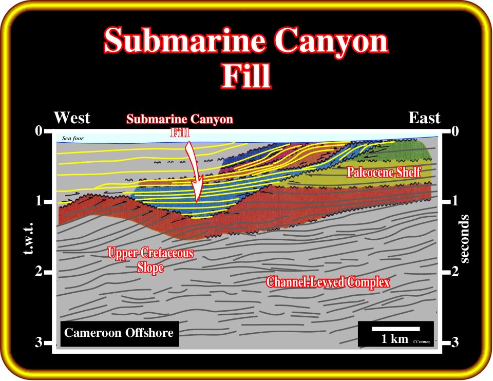
Plate 442- This sequential analysis of the previous tentative interpretation strongly suggests that the submarine canyon was filled by depositional systems of a lower systems tract belonging to the light blue sequence-cycle (slope or basin floor fans).
Exploration Applications:
1) Reservoir :
- Very variable ;
- Submarine channel sands, turbidites ;
- Poor continuity.2) Migration :
- Uncertain ;
- Vertical migration via faults may be best.3) Source :
- Uncertain ;
- Contemporaneous source is probably gas prone.4) Trap :
- Stratigraphic pinchouts.
5) Seal :
- Local shale seals.
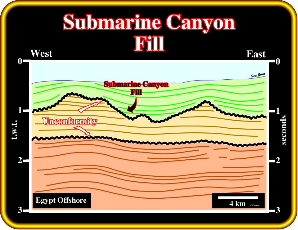
Plate 443- This tentative interpretation of seismic line, from offshore Egypt, cuts several times a submarine canyon, which deeply eroded the old slope sediments. The internal configuration of the submarine canyon fill (SCF), as well as the actual geometry of the reflection terminations, can only be determined with a set of lines striking more or less perpendicularly. Explorationists should never forget that the geometric relationships recognized in a seismic line could be apparent. The geometric relationships have a geological meaning when they are in their original position, i.e., when the tectonic deformation is taken away.
Exercises:
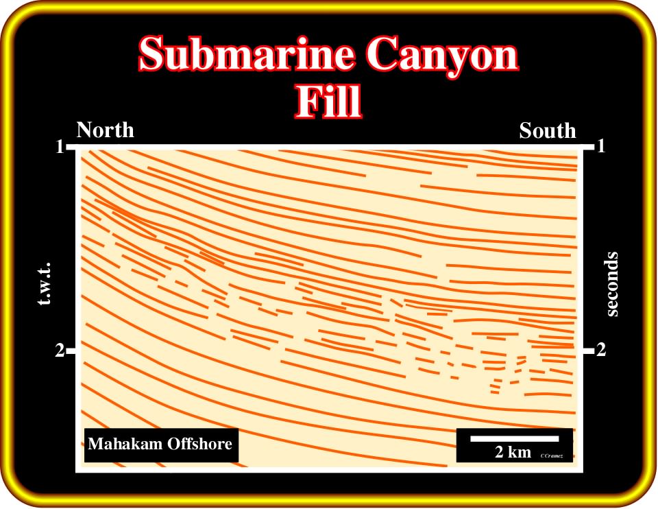
Plate 444- On this first step tentative of a seismic line from offshore Indonesia, there are three sequence-cycle boundaries, i.e., three unconformities, which are easily recognized by the associated submarine canyons. Knowing that the lower submarine canyon cuts at least twice the seismic line, pick the unconformities. Then, criticize your interpretation and the one proposed in the next plate.
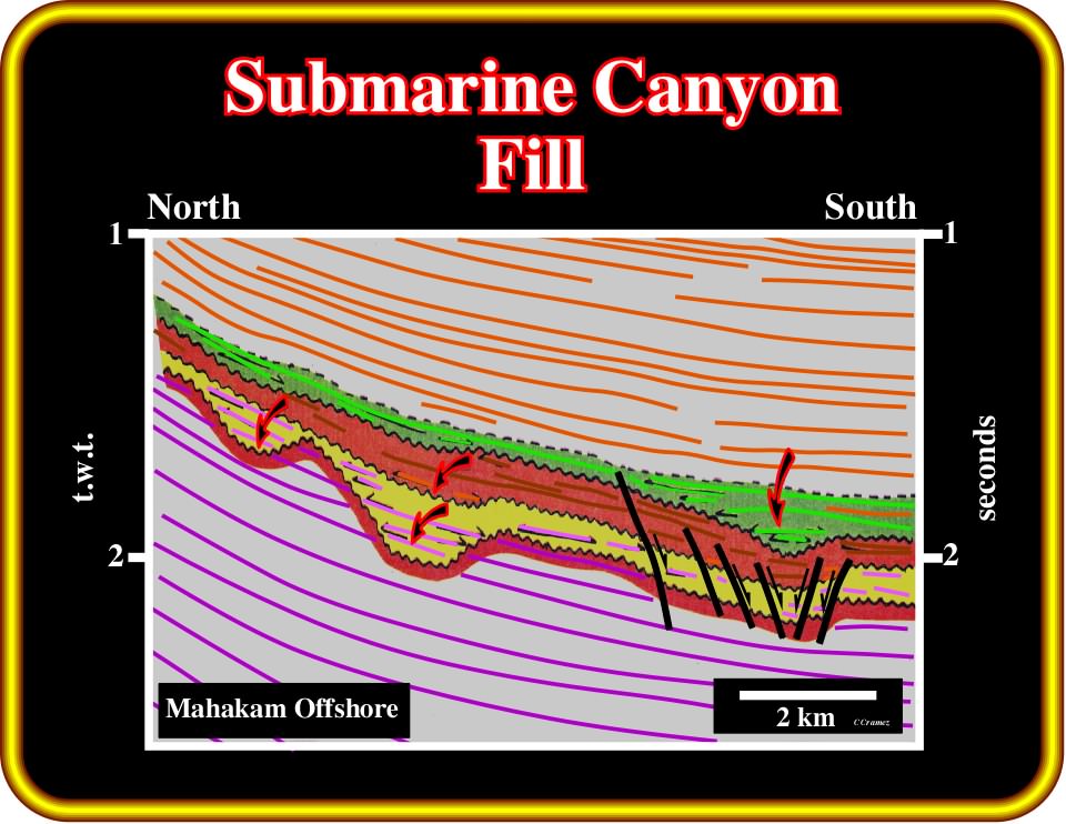
Plate 445- On this tentative interpretation, three submarine canyons are recognized. The lower submarine canyon seems to be cut twice by the seismic line. On the right part of the line, the lower sequence boundaries (below the upper submarine canyon), were lengthened by normal faults rather than eroded. Other explanations cannot be excluded. How did you interpret this area?
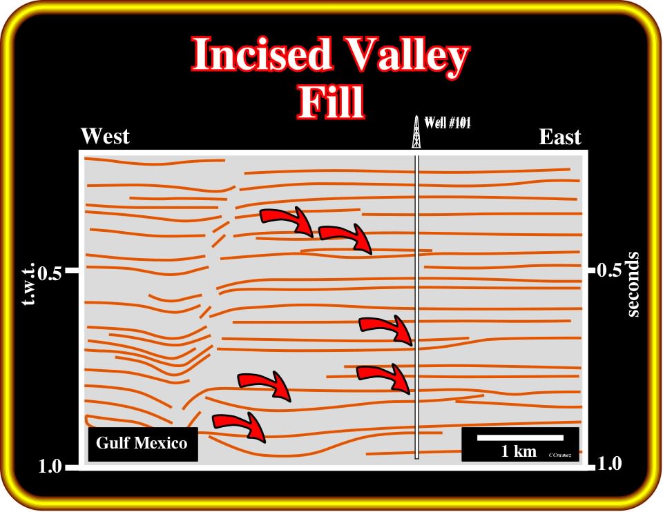
Plate 446- When relative sea level falls are big enough to exhume the platform, the equilibrium profile of the rivers is broken. They are obliged to incise their beds to reach a new equilibrium profile creating what we call in sequential stratigraphy an incised valley (IV). Later, when the relative sea level rises, during the deposition of the upper section of the lowstand prograding wedges, the incised valleys are filled by lowstand sediments forming incised valley fills (IVF). On this first step tentative of seismic line, from the Gulf Coast, two incised valley fills were penetrated by the well #101. The log patterns of such lowstand intervals are shown on next plate.
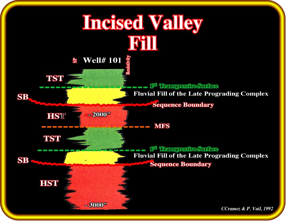
Plate 447 - Two incised valley fills can be recognized on the electric logs of the well #101. The SP illustrates that both incised valley fills (IVF) have sharp limits and and a sandy facies. The lower limits emphasize the upper boundary of the underlying sequence-cycle, while the upper limits correspond to the first flooding surfaces of the overlying transgressive systems tracts.
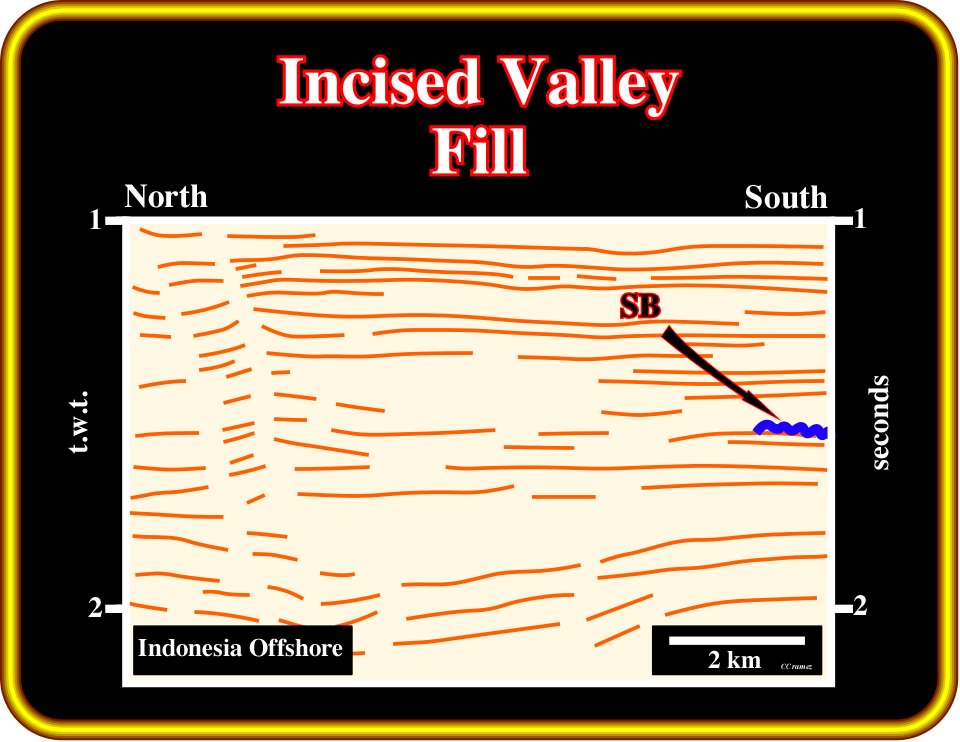
Plate 448- Taking into account that the depth of an incised valley (IV) is much smaller that the depth of a submarine canyon, the recognition of incised valleys or incised valley fills can be quite subtle. However, as they are always associated with stratigraphic cycles boundaries, an easy way to recognized them is to pick unconformities near shelf breaks, where seismic surfaces are generally obvious, and follow them landward detecting all associated erosional surfaces. Assuming that on this first step tentative interpretation, the blue colored horizon (SB) corresponds to a sequence boundary, following it northward you will recognize at least two incised valleys as illustrated in the next plate.
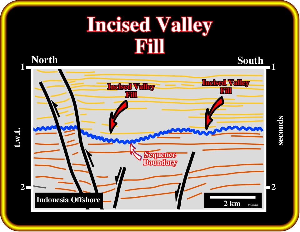
Plate 449- Generally, in a regional seismic line, an unconformity is picked near the shelf break, where the associated onlap or a toplap seismic surfaces are morphological enhanced. The blue marker corresponds to an unconformity, which was calibrated near the shelf break. Thus, all erosional anomalies (see first step interpretation on Plate 448) associated with it can be likely interpreted as incised valley fills. Often, it is the recognition of incised valleys that allows one to pick the exact location of unconformities. This is particularly true, in platform environments when unconformities are not tectonically enhanced.
Exploration Applications:
1) Reservoir :
- Braided stream sands typical.
- Good to fair continuity.2) Migration :
- Downward from TST possible vertical via faults.
3) Source :
- Top source from TST possible deep sources.
4) Trap :
- Typically requires structural closure or nose.
5) Seal :
- TST shales. Poor lateral seal.
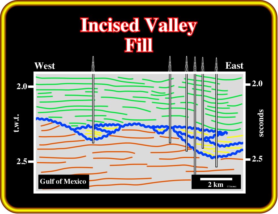
Plate 450- Often, in the Gulf of Mexico, incised valley fills are important migration/entrapment petroleum subsystems, i.e., they contain the principal reservoir-rocks and create, at least partially, the trapping mechanism as illustrated next.
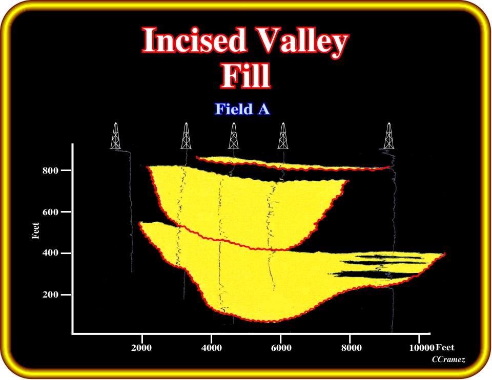
Plate 451- The field A shown on the tentative interpretation (Plate 450), is here illustrated by the Gamma Ray log of five wells. In spite of the fact that incised valley fills are, locally, stacked, the proposed structural correlation corroborates a stratigraphic trapping. Note that a corroboration of a hypothesis means just that the data did not refuted it. In other words, new geological or seismic data can refute the hypothesis of a stratigraphic trapping.
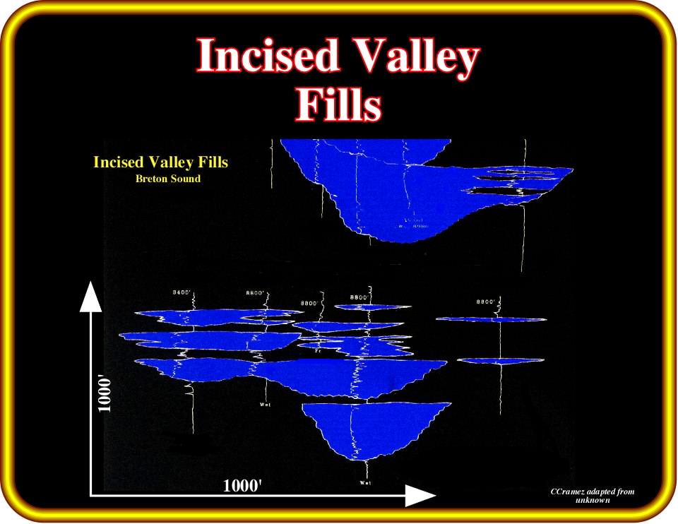
Plate 452- On these structural correlations, the incised valley fills are connected vertically, but also laterally. When the lateral sealing is assured, as the overlying transgressive shales are excellent sealing-rocks, significant stratigraphic traps are likely. The majority of these non-structural traps were discovered due to associated seismic amplitude anomalies. When there are no amplitude anomalies associated with the accumulations (below the inversion surface), detailed sequential stratigraphic analyses are required to localize potential traps. Unfortunately, the majority of explorationists working in the GOM are unable to perform them.
to continue press![]()
![]()