
Universidade Fernando Pessoa
Porto, Portugal
Seismic-Sequential Stratigraphy
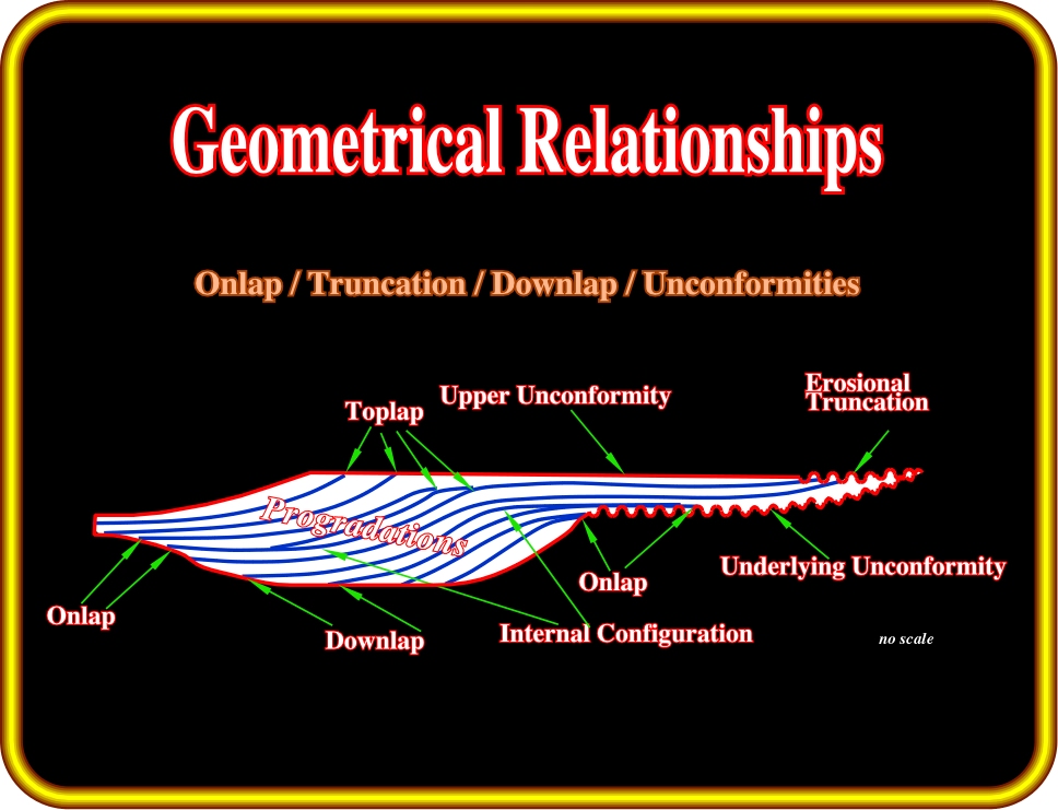
Plate 141 - In the next pages, we will review the geometrical relationships (reflection terminations) associated with stratigraphic cycles and particularly with sequence-cycles, i.e., stratigraphic cycles associated with 3rd order eustatic cycles also the building block of sequential stratigraphy. Each geometrical relationship will be defined and illustrated on a regional seismic line. We will try to explain its meaning in geological terms.
A base-discordant relation in which initially (deposition time) horizontal strata terminate progressively against an initially inclined surface, or in which initially inclined strata terminate progressively updip against a surface of greater initial inclination. Varieties of onlap are:
(i) Proximal onlap
(ii) Distal onlap
(iii) Coastal onlap
(iv) Marine onlap
(v) Apparent onlap
(vi) Nonmarine onlap
(vii) True onlap
(viii) Tilted onlap (Apparent downlap)
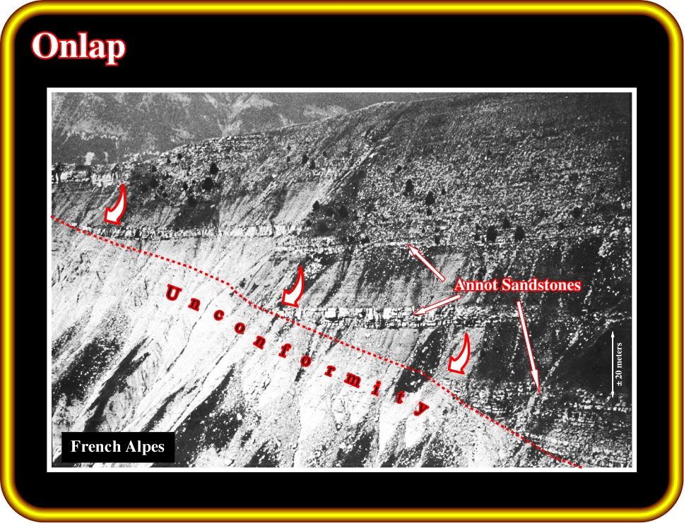
Plate 142 - The Annot sandstones are deep-water turbiditic lobes, which onlap over a major unconformity. As illustrated, one can say, the unconformity (in this case a marine erosional surface) is fossilized by the onlapping of turbidite depositional systems. As we will see later, in this particular instance (turbiditic deposition), the onlap relations do not correspond to a relative sea level rise, but to the stacking of successive turbidite lobes induced by gravity currents, which generally developed during lowstand geological situations.
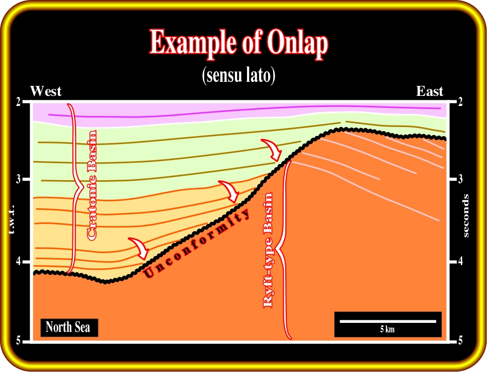
Plate 143 - The North Sea is composed of three different sedimentary basins that are stacked together. From bottom to top geologists generally have no major difficulties recognizing a Paleozoic fold belt (not illustrated on this line), often considered as a petroleum basement, a Mesozoic rift-type basin and a Cenozoic cratonic basin. On this seismic line, it is easy to recognize that cratonic Cenozoic sediments onlap Mesozoic rift-type basin sediments. Geologists, and particularly seismic interpreters, using the reflection terminations of the Cenozoic sediments, consider that an onlap seismic surface (not emphasized by seismic reflectors) exists between the Mesozoic and Cenozoic intervals. Generally, onlap represents a marine (or lacustrine) transgression over old sediments, i.e., a relative sea level rise. Different types of onlap can be recognized either on the ground or on the seismic lines.
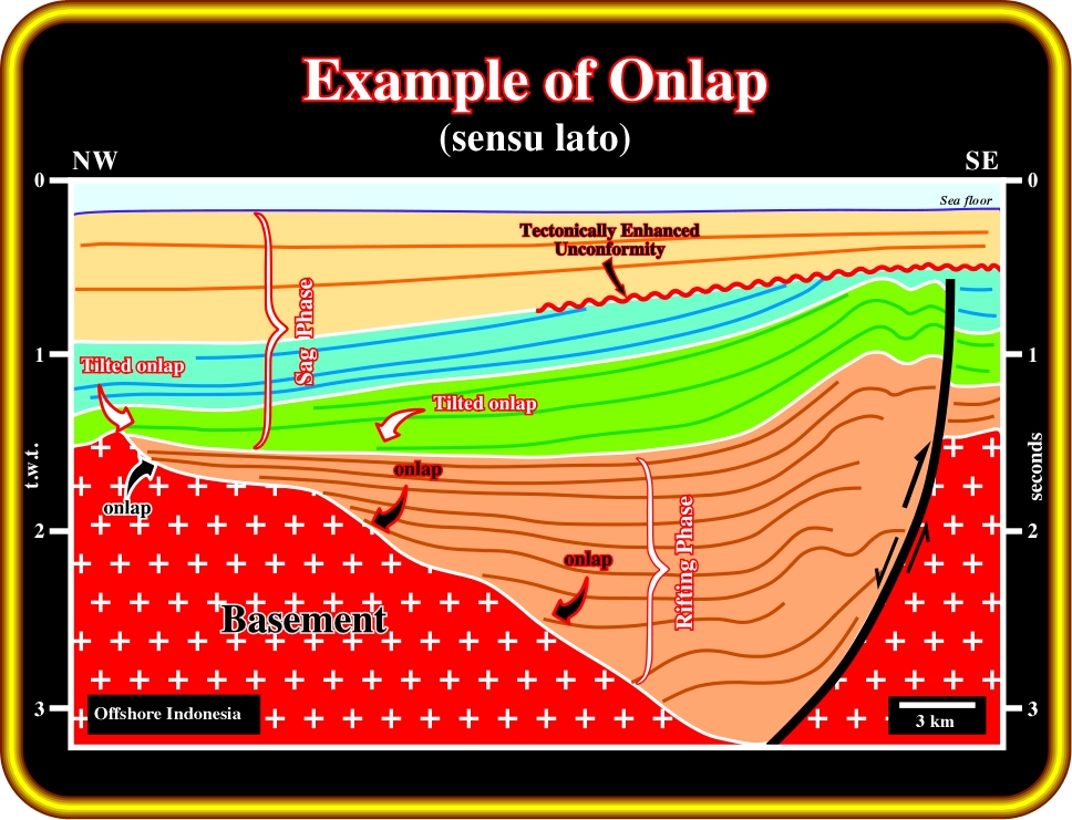
Plate 144- The pristine geometrical relationships (deposition time) are often deformed by later tectonic regimes, as illustrated on this seismic line from a SE Asia back-arc basin. Indeed, it is quite easy to infer that a compressional tectonic regime took place after the rifting phase of the backarc basin. In fact, the old normal faults of the rift-type basin were reactivated as reverse faults tilting the original geometrical relationships between the seismic markers. When the tilting is strong enough, onlapping can apparently become another geometrical relationship, as it is the case in the orange seismic interval.
(i) Proximal Onlap
Proximal onlap is onlap in the direction of the source of clastic supply.
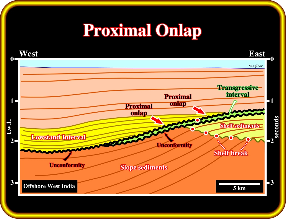
Plate 145 - As the source of clastic supply is located eastward, the red arrows underlie proximal onlaps, which can be coastal or marine, depending whether they are associated with marine sediments (seaward of the shelf break) or shallow marine (depositional coastal break). On this line, coming from offshore West India (Atlantic-type divergent margin), the onlaps are coastal. They are associated with the aggradation of a lowstand regressive interval (Lowstand prograding wedge (LPW), see later). They fossilize an unconformity (seismic onlap surface) induced by a relative sea level fall, which took place between the transgressive interval (green) and the regressive lowstand interval (in yellow).
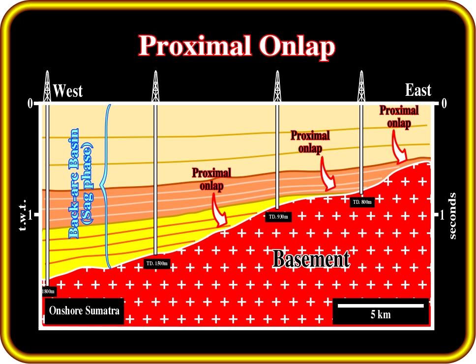
Plate 146 - On this seismic line from onshore Sumatra (Cenozoic back-arc basin induced by a Benioff or B-type subduction zone), the proximal onlaps of the seismic reflectors (upper seismic packages of the sag phase) are easily recognized. Actually, taking into account the proposed geological interpretation, it is quite evident that the more likely source of clastic sediments is the basement, which outcrops few kilometers eastward. Theoretically, the onlap seismic surface, between the sag sediment terminations and the basement (granito-gneiss or Paleozoic fold belt), is created by the coastal aggradation of the regressive intervals of the back-arc basin. However, deep-water turbidite depositional systems are deposited during relative sea level falls, generally in lowstand geological situations .
(ii) Distal Onlap
Distal onlap is onlap in the direction away from the source of clastic supply.
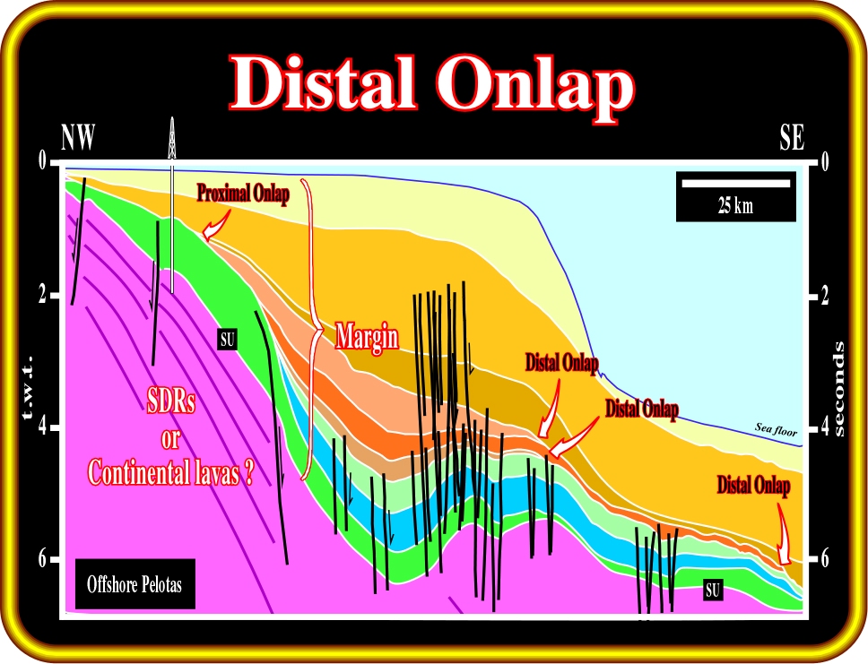
Plate 147 - Distal onlaps are easily recognized on this regional seismic line of the offshore Brazil (post-Pangea Atlantic-type divergent margin). In this margin, the petroleum basement is mainly composed by Mesozoic subaerial lava flows, which locally can overly Precambrian and Paleozoic sediments. The most likely source of clastic sediments are the rocks of the infrastructure (Precambrian or Paleozoic rocks) and the post breakup lava flows. Both outcrop westward. Subsequently, distal onlaps of the Atlantic-type margin, as stressed above, are the reflection terminations in the direction away from the source of clastic supply (southeastward terminations). The unconformity (SU), on the top of the lava flows (seaward dipping reflectors), is not the breakup unconformity. In fact, it is more or less 10 My younger than the breakup unconformity (BUU), which is not illustrated on this line.Take into account the pitfall induced by the sharp change in water depth.
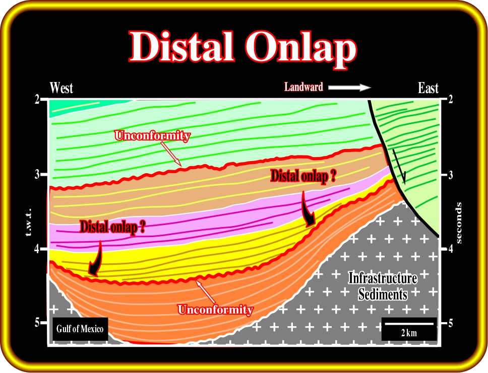
Plate 148 - This seismic line comes from the deep-water Gulf of Mexico (Cenozoic Mediterranean-type basin overlying a Mesozoic Pannonian basin). Reflection terminations and seismic surfaces are quite easy to recognize. However, in spite of the fact that the source of clastic sediments is located eastward (landward), is quite difficult to differentiate proximal from distal onlap. Indeed, due to salt flowage (halokinesis) and particularly due to salt evacuation, salt expulsion basins (minibasins) control the movement of gravity currents, which can take fancy trajectories. Subsequently, in a salt minibasin, a distal onlap does not necessarily mean that the onlap is in the direction of the major source of clastic supply. In other words, the direction of the source of clastic supply does not necessary corresponds to the direction of the sediment transportation, particularly in deep-water minibasin environments.
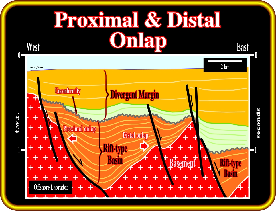
Plate 149 - On this line from the Labrador offshore, the geometry of the rift-type basin, as illustrated, is often that of a half-graben. The infilling sediments thick landward toward the normal fault planes (the subsidence is differential). Such a feature, strongly suggests that the direction of the source of clastic supply is from west to east. Subsequently, proximal onlaps look westward (landward), while distal onlaps look eastward (seaward). However, it must be noted that the onlap are non-marine. The predominant geological environments in rift-type basins are alluvial and fluvial. In addition, under certain climate and geological conditions, lacustrine environments can develop, as such, organic rich lacustrine shale can be deposited (potential source-rocks).
(iii) Coastal Onlap
Coastal onlap is the progressive landward onlap of the coastal deposits in a given stratigraphic unit.
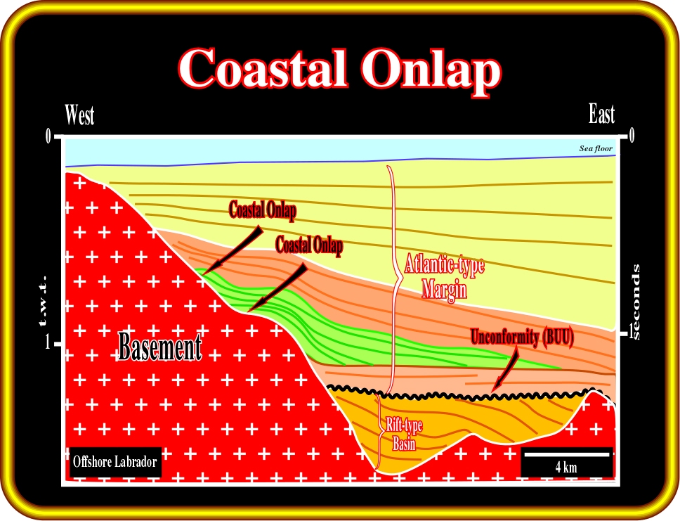
Plate 150 - The offshore of Labrador corresponds to a Cenozoic Atlantic-type divergent margin, which overlies Mesozoic rift-type basins, i.e., half-grabens which lengthened the lithosphere during the rifting phase (before breakup and subsequently oceanization). The green interval represents a transgressive sedimentary package of the margin developed during a relative sea level rise. In this interval, the coastal onlaps are quite evident. The coastal aggradation (vertical component of coastal onlap) of this transgressive interval is around 400 milliseconds and coastal encroachment (horizontal component of the coastal onlap) is roughly 4000 meters. For a given stratigraphic unit, the knowledge of the coastal aggradation and coastal encroachment allows prediction of the most likely topography of the underlying unconformity on which the unit transgressed. The breakup unconformity (BUU) between the rift-type basins and margin corresponds to a sharp change in environmental conditions.
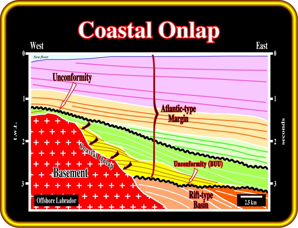
Plate 151 - This seismic line is located not very far from the line illustrated on the previous plate (Plate 150). It illustrates coastal onlaps in a transgressive interval, which are easily recognized by the backstepping geometry. At each relative sea level rise, the depositional coastal break is displaced landward. Then, during a more or less stillstand of sea level, the depositional coastal break is progressively displaced seaward as sedimentation takes place. However, it never reaches the position of the last depositional coastal break of the previous parasequence. A new relative sea level rise, again, displaces the depositional coastal break landward, and so on. This depositional mechanism is responsible of the backstepping geometry of the transgressive deposits, which, in fact correspond to a set of less and less regressive deposits. In other words, each parasequence in a transgressive interval has a progradational (forestepping) or regressive geometry as indicated by progressive landward onlap.
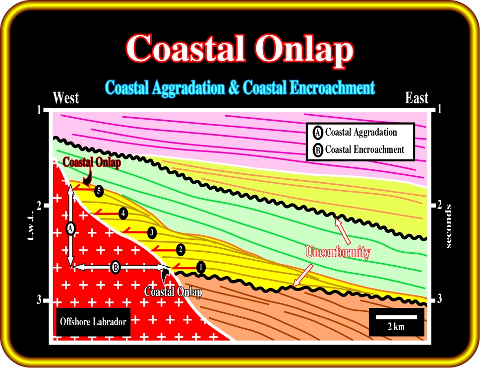
Plate 152 - This line illustrates coastal aggradation (A), i.e., the vertical component of the coastal onlap of a regressive interval (green) and coastal encroachment (B), that is to say, the horizontal component. Coastal encroachment is measured in kilometers, while the coastal aggradation is measured in milliseconds (two way time). A quickly time/depth conversion of the coastal aggradation, as we will see later, gives the total relative sea level rise. Knowing the coastal aggradation (in meters, or kilometers) and coastal encroachment, it is possible to get an idea of the morphology of the basement over which the sediments transgressed. A high coastal encroachment coupled with an high aggradation characterizes a flat morphology of the underlying unconformity (eventually basement), while a small aggradation and a small encroachment characterizes a steep morphology.
(iv) Marine Onlap
Marine onlap is the onlap of marine strata, primarily deep marine (deposited seaward of the shelf break) in nature.
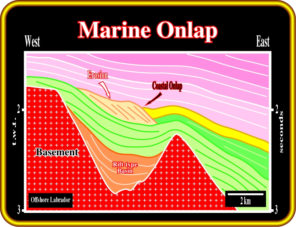
Plate 153 - On this line, geologists have considered the onlap of the yellow interval as a marine onlap. I think that it is rather coastal onlap than marine onlap. Indeed, in the central part of the line, it is easy to recognize a lowstand regressive interval, bounded above by an erosional surface. The upper parts of the progradations, forming the regressive interval, were partially eroded. So, at the time of erosion, that is to say, at the end of the regressive interval, the basin did not have a shelf. The depositional costal break was coincident with the shelf break. Subsequently, following a small relative sea level fall, the coastal deposits were slightly shifted seaward and basinward, and so, the onlap of the yellow interval must be considered as a coastal onlap. Marine onlaps, as illustrated on the next plate, occur when the basin has a shelf (coastal break and shelf break not coincident) or when the relative sea level fall is big enough to create a change of environment of the depositional systems.
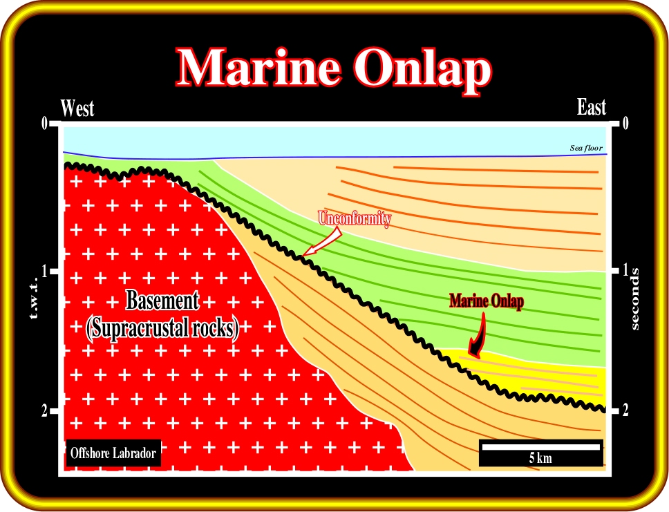
Plate 154 - On this line from offshore Labrador (parallel to the direction of the source of clastic supply), the turbidite depositional systems of a basin floor fan interval (yellow package) onlaps (marine onlap) on a major unconformity (in black), which seems to have been induced by an eastward tilting of the basin. As with coastal deposits one could speak of marine aggradation and marine encroachment. However, traditionally, geologists keep aggradation and encroachment to express the vertical and horizontal components of coastal onlap. Marine onlap implies a significant depositional water depth. In coastal onlap, the water depth is practically zero. In spite of the fact the basement is mainly composed by Precambrian supracrustal rocks, the majority of the reflectors visible in the basement are seismic artifacts, mainly peg-legs.
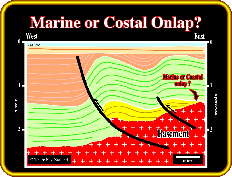
Plate 155 - On this line, from offshore New Zealand, compressional structures are paramount. These structures seem to have been developed by a significant tectonic inversion. Indeed, it is quite possible that the old normal faults, developed during the rifting phase (extensional phase), were later, during a compressional tectonic regime, reactivated as reverse faults. If such a tectonic interpretation is not refuted by additional data, the onlap recognized on the yellow seismic interval is coastal (or nonmarine) rather than marine. Actually, in this tectonic interpretation, the yellow interval is interpreted as the fill of a rift-type basin, which are generally filled by non marine sediments. However, this line can be interpreted in a differently way , as illustrated on the next plate.
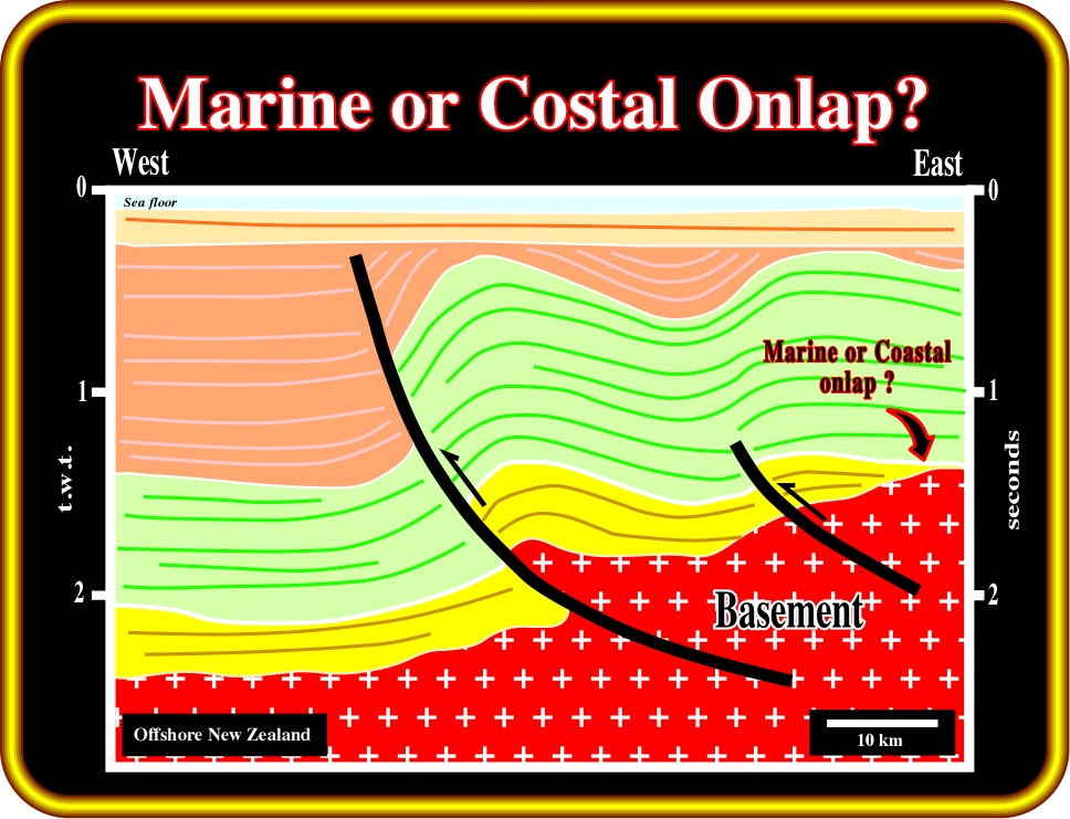
Plate 156 - On this interpretation, the yellow interval is interpreted not as a rift-type basin, but as a marine interval, likely a deep-water turbidite package deposited over a basement. If such a hypothesis is not refuted, the geometrical relationships between the yellow strata and the basement must be interpreted as marine onlap. This example clearly indicates that seismic interpretation cannot be done in isolation. It is strongly dependent of the regional and global geological settings. On the other hand, geologists, and particularly seismic interpreters, should never forget that there are no true interpretations. All seismic interpretations will be, sooner or later, refuted by new geological data. Strictly speaking, a seismic interpretation can never be verified. It can only be validated or corroborated.
to continue press![]()
![]()