
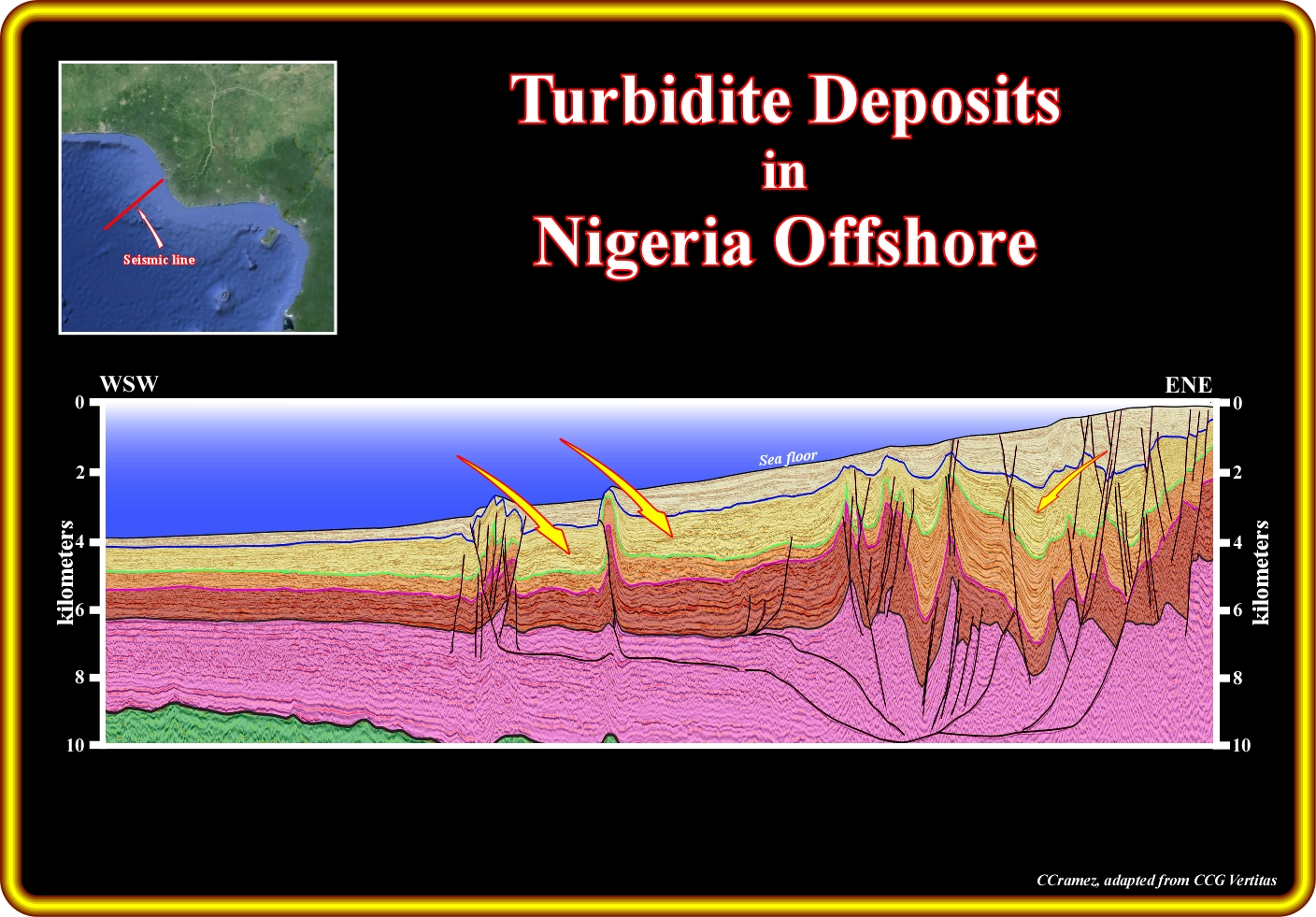
On this geological tentative interpretation of a regional line from the Nigeria offshore (there is no horizontal scale due to confidential reasons), the conventional turbidite deposits are likely in deepwater of the regressive (progradation) interval of Tertiary age. Some of these turbidite deposits are associated with structural traps created by the compressional tectonic regime developed in deep water, as an answer to the updip extension of the platform and upper slope. In fact, as illustrated in this tentative, the major faults are listric (from the Greek listron, that means spoon), that is to say, the updip normal faults, which lengthened sediments, become downdip reverse faults, which shortened and uplift the sediments, in order to not create volume and respect the Goguel' law (during deformation, the amount of sediments is keep, more or less, constant, taking into account the lost of volume by compaction and dissolution). The deep water turbidite deposits are, mainly, associated with turbidite currents triggered by relative se level falls (Vail's turbidite model). Turbidite currents induced by slope failures and flush floods, during highstand geological conditions (Mutti's model) took place, also, during the geological history of this offshore.
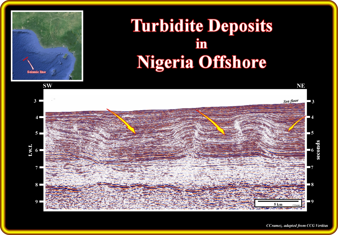
On this line, under quite high water depth (3-4 seconds t.w.t.), the structural traps (four way dips structures) created by local compressional tectonic regime induced as a response to the updip extensional tectonic regime which affect the upper slope and platform sediments. In this area, turbidite deposits are likely, but taking into account their location, that is to say, far away from the areas where sandy sediments are abundant, most likely their facies is shaly without interest for oil exploration, assuming the presence, in the area, of a generating petroleum subsystem.
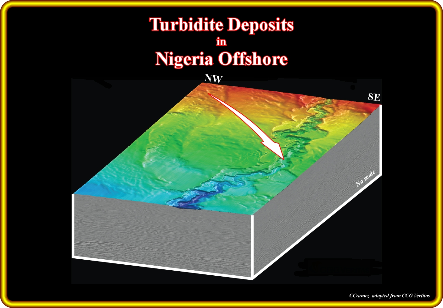
This block diagram, made with 3D seismic lines, shows, in the upper part a seiscrop, in which channelized turbidite deposited are obvious. The meandriform geometry of such a turbidite deposits seems correspond to the turbidite construction / aggradation phase. The facies is probably shaly, without significant reservoirs-rocks, since the depositional systems are mainly channel-levees complexes, i.e., equivalent of the "gully-wings" of P. Vail. Theoretically, below this shaleprone turbidites one should find lobes and overbank deposits, which fossilize the underlying sediments of the basal erosion / infilling phase, which facies is, generally, sandy with a lot of potential reservoir-rocks and small potential morphological traps.
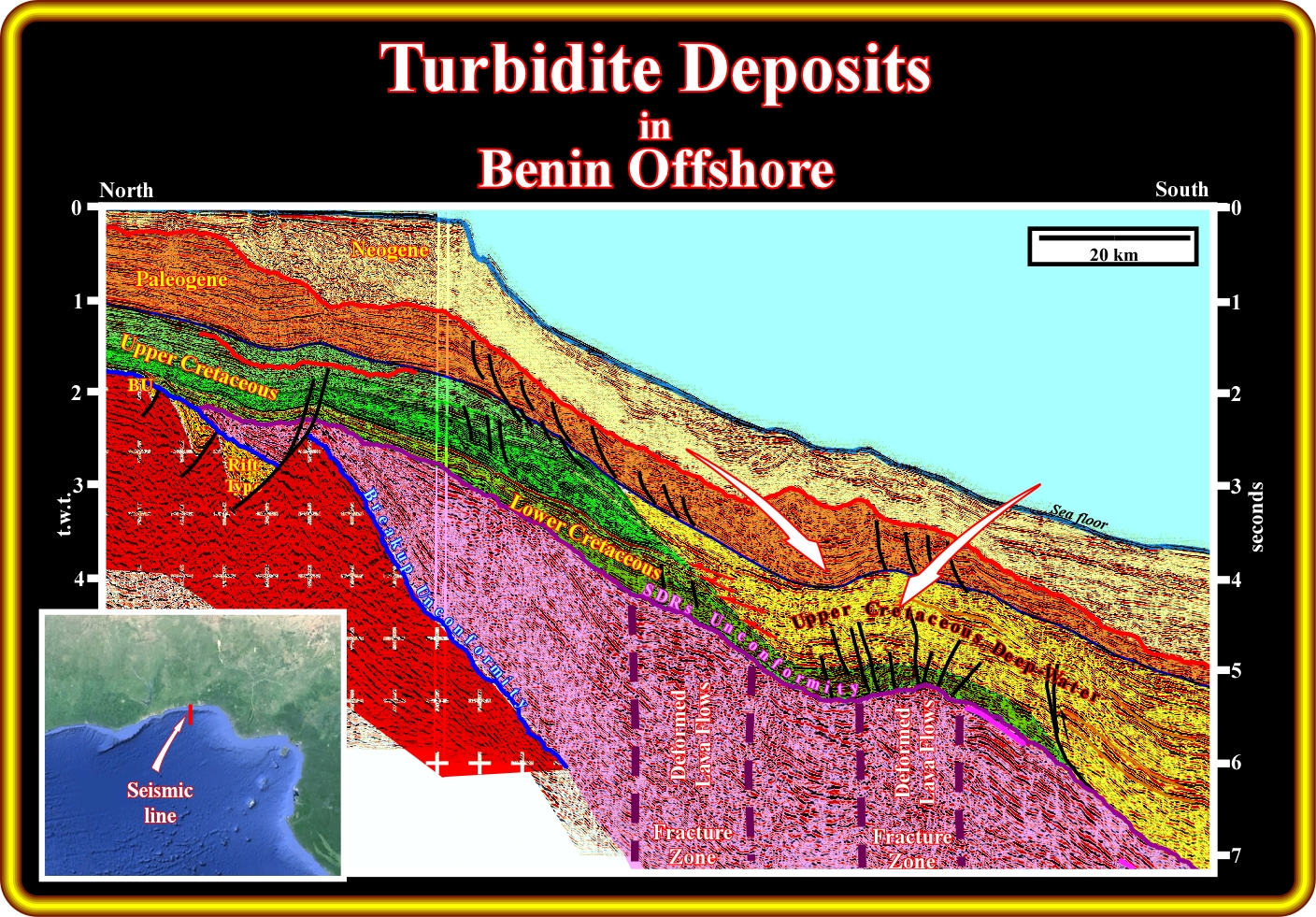
On this geological tentative interpretation of interpretation of a regional seismic line of the Benin offshore, the more likely location of the turbidite deposits, that is to say, of potential reservoirs-rocks and morphological traps is quite obvious. As illustrated, their age is either Upper Cretaceous either younger (Paleogene or Neogene). Apparently , the Upper Cretaceous turbidite deposits seems to be better explained by the Vail's turbidite model, which is a macroscopic model (at the scale of the seismic lines and geological maps) mainly based on seismic data. On the contrary, the presence of slope/platform failures and landslide in the Paleogene and Neogene sediments suggest that the Tertiary turbidite sediments follow the Mutti's turbidite models, which is a mesoscopic model (at the scale of the outcrops), that is to say, mainly based in field data. This tentative interpretation takes into account several geological features, which have tremendous consequences on the hydrocarbon potential of this deep-water offshore. Firstly, the presence of seaward dipping reflectors, which are located seaward of the continental crust (Paleozoic or/and Precambrian) and interpreted as post-breakup lava flows (without generating hydrocarbon potential). Secondly, the rift-type basins (on the left, in yellow) located within the continental crust, i.e., landward of the actual shelf break, are too small (absence of generating petroleum subsystems). Thirdly, the Cretaceous transgressive interval (green), where potential marine source-rock intervals are located, is present. This interval has a backstepping geometry and corresponds to the transgressive stratigraphic phase of the post-Pangea continental encroachment cycle. However, its burial (taking into account the water depth) does not seems to be appropriated. Lastly, the reactivation of the fracture zones deformed (lengthened), locally, the margin sediments, particularly the turbidites deposits, creating antiforms (extensional structures) transforming the original morphological traps into morphological traps by juxtaposition. There are not structural traps, that is to say, four way dips traps induced by shortening (compression).
No data
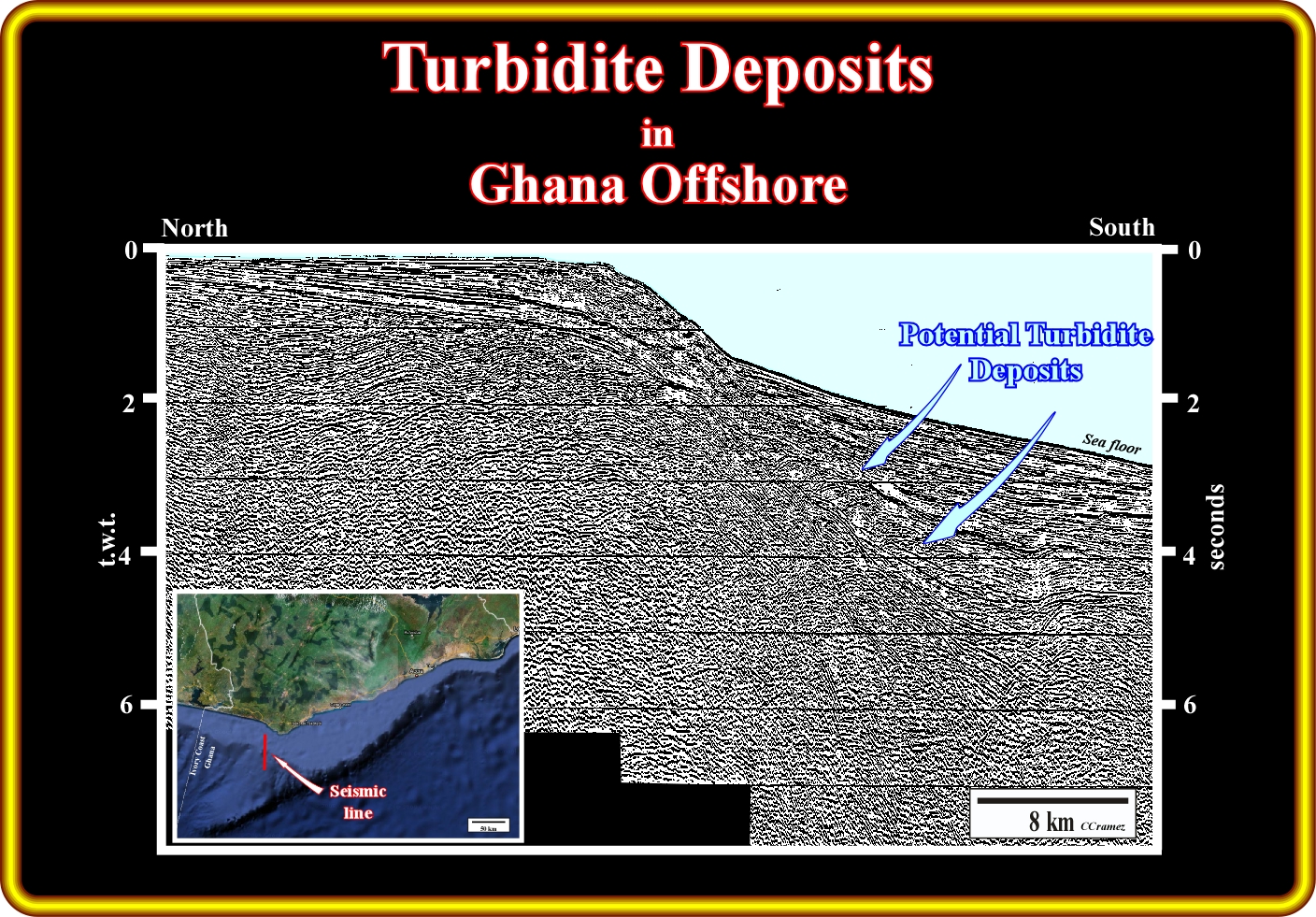
On this old unmigrated North-South seismic line from Ghana offshore, taking into account the regional geological context and, particular, the presence of several major fractures zones oriented roughly West-East, it is facile to prognosticate the more likely location of the potential Tertiary turbidite deposits. In fact, a trained geoscientist in seismic interpretation of the unmigrated seismic lines (more and more scarce in the oil companies), recognizes easily the tectonically enhanced Top Cretaceous unconformity, which is fossilized by onlapping of the Tertiary deepwater and turbidite sediments (see next plate). Actually, it is not difficult to assume that the relative sea level fall, which cause the unconformity (erosional surface) at the top Cretaceous, exhumed the old continental platform (shelf), obliging the shoreline (coastal onlaps) and the mouth of the rivers to shift seaward (lateral displacement) and basinward (negative aggradation). Such a displacement broke the provisional equilibrium profile of the rivers, which were oblige to incise their beds in order to reach a new provisional equilibrium (a total or final equilibrium does exist; there are no streams that do not carry sediments and do not erode). In other words, not only the terrigeneous influx, arriving to the sea, increase strongly, but its discharged being on the upper continental slope trigger turbidite currents down to slope. The carried sediments by the gravity currents down to slope are deposited as turbidite since the currents loose competence and capacity.
On this modern seismic line of the Ghana offshore, shot no far from the line illustrated in the previous plate, the geological history seems, apparently, more evident than in the last plate (unmigrated seismic line), but, in fact, it is exactly the same. Do not forget that a geoscientist in charge of the geological interpretation of the seismic lines recognize on a seismic line just what he knows and what he is looking for. In other words, if a geoscientist does not know what is an unconformity, he never recognize it, he is going to propose just a naive interpretation without any geological interest (ex.: "This yellow bodies seem interesting", "What do you think about the Mickey mouse structure?" or "Here, there is a fault because I cannot close the seismic loop", etc.). By the same token, if he or her does not known what is a relative sea level fall or a turbidite deposit he never recognize them in any seismic line, even if his boss gives him a 3D seismic data (this corresponds to give a Ferrari to somebody than cannot drive and does have a drive license). So, on this line, above the Top Cretaceous unconformity, which developed, in the area, lowstand geological conditions, i.e., which put the sea level below that the shelf break (the basin no longer have a continental platform), one can easily recognize turbidite deposits (probably with reservoir-rocks), which onlap over the unconformity. On this subject, it is interesting to remind that when a geoscientists is looking for reservoir-rocks on seismic lines, he must perform tentative geological interpretations using a sequential approach (Sequence Stratigraphy, Vail), in which the different stratigraphic packages (stratigraphic cycles) are bounded by unconformities, since all potential reservoir-rocks (deepwater or shallow water) onlap against the unconformities. However, if the geoscientists, is looking for potential source-rocks intervals, he must tentatively interpret the seismic lines using a genetical approach ( Genetic Stratigraphy, Gallows), since the different stratigraphic packages are bounded by downlap surfaces, with which potential source-rock intervals are associated.
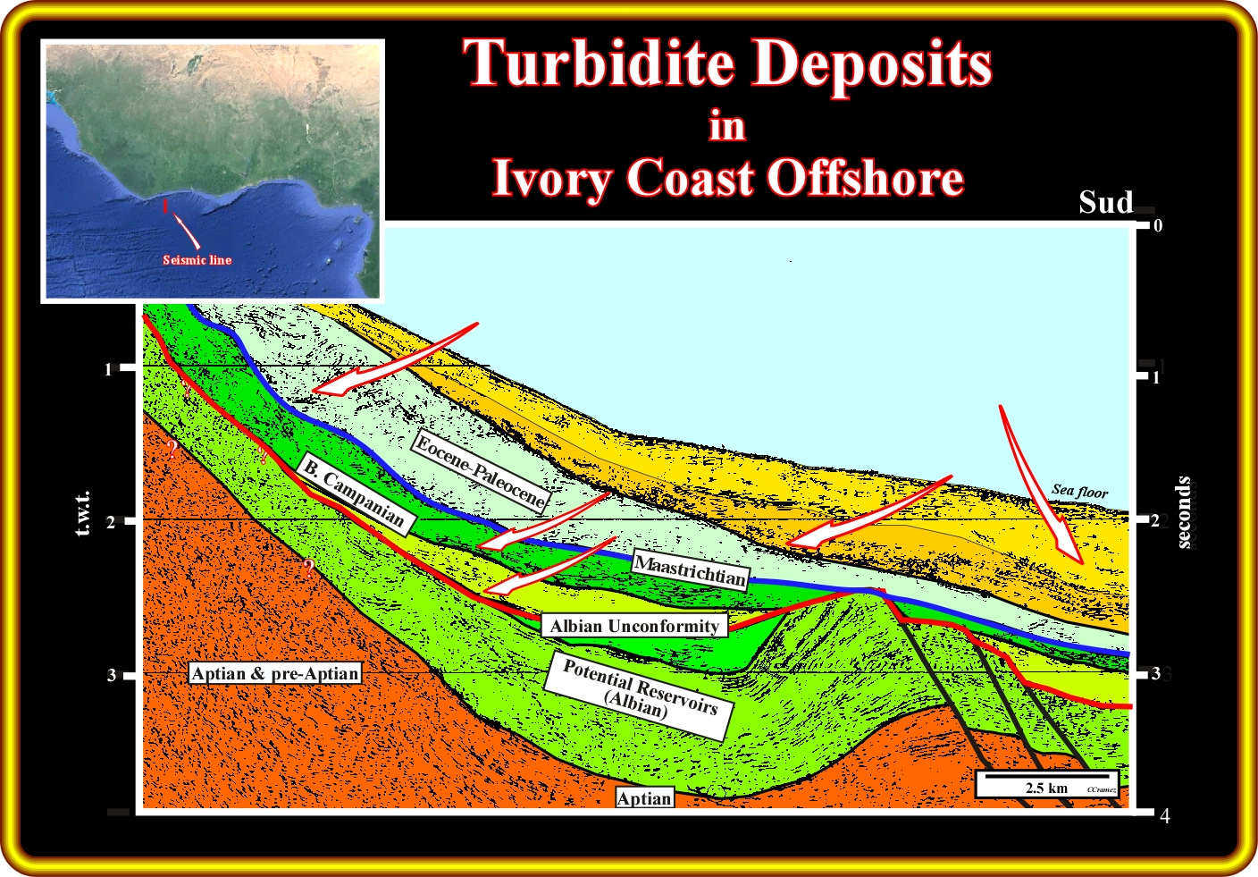
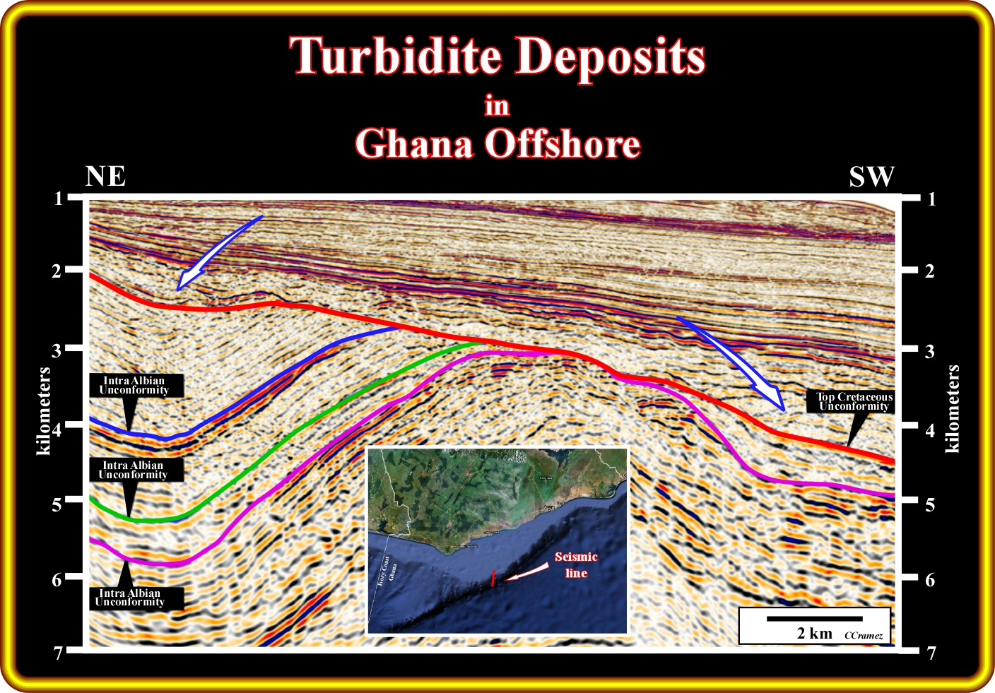
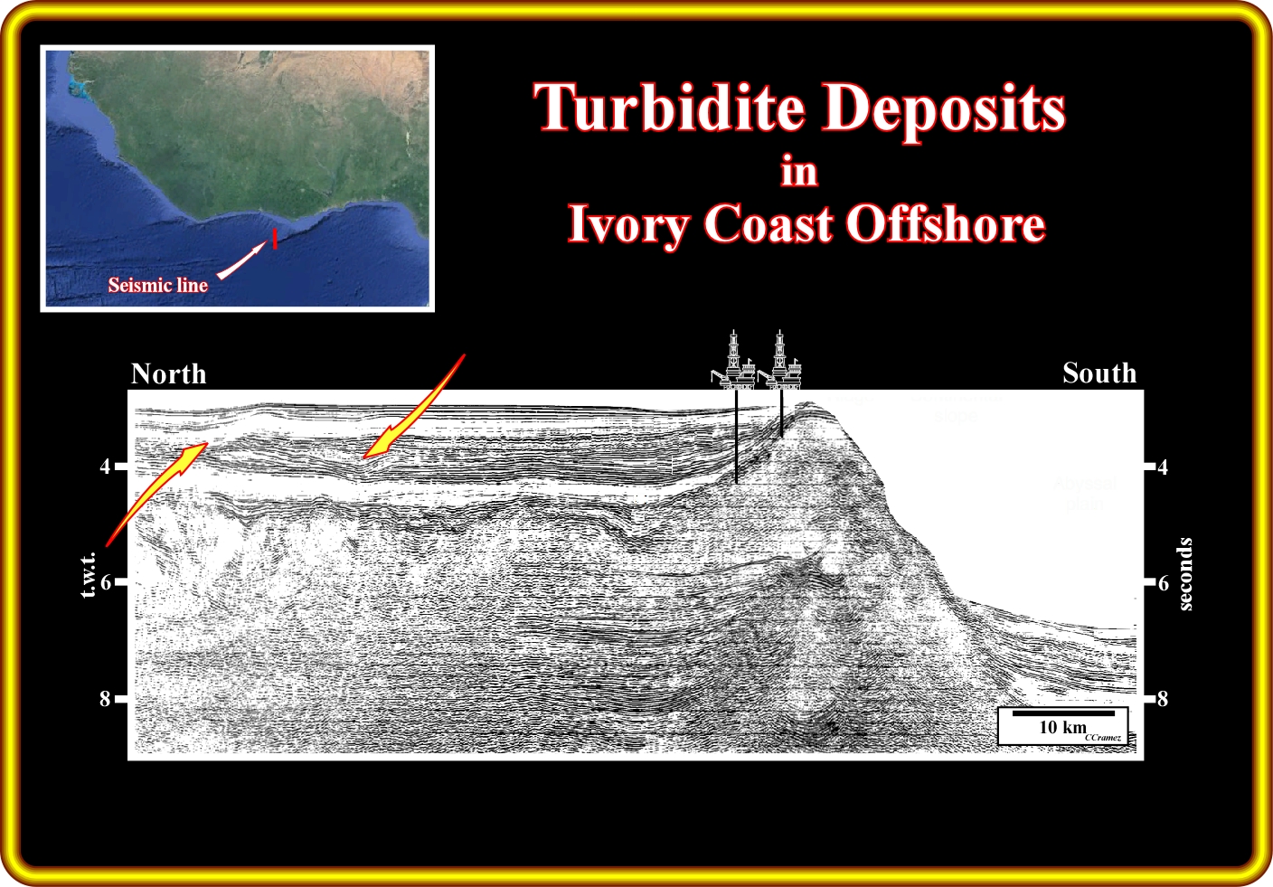
The geology of the Ivory Coast offshore is similar to that of the Ghana offshore. In fact, as suggested on this geological tentative interpretation of a North-South seismic line of the Ivory Coast offshore, the Top Cretaceous unconformity (in blue) is easily recognized as well as the potential Tertiary turbidite deposits (point out by arrows). Above the Albian unconformity, particularly, in Campanian and Maastrichtian, turbidite deposits are likely, mainly in association with the slope and platform failures, landslides and relative sea level falls induced by the uplift created by the reactivation of the fracture zones, which strongly affect this offshore, as illustrated in the next plates.
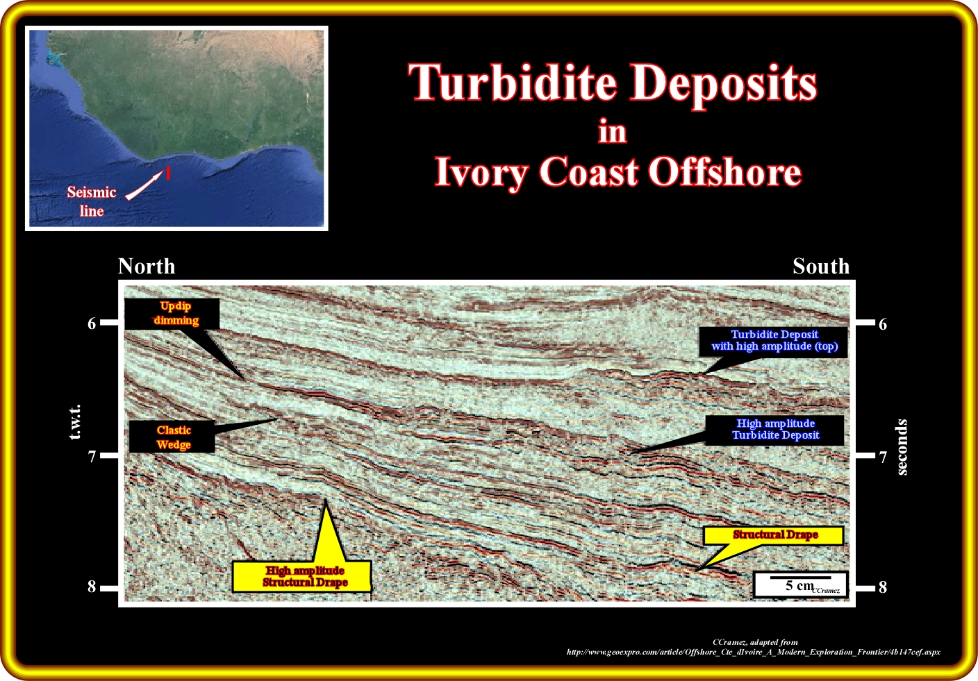
On this close-up of a seismic the deepwater Ivory Coast offshore, there is a strong evidence of turbidite deposits downdip of the successive Tertiary continental slopes. All these turbidite deposits onlap against unconformities (relative sea levels falls). In some of them the erosive infilling phase is subtile and without sharp high amplitudes anomalies, while the constructive aggradational phase is very evident, not only by its gully-wing geometry, but also by the sharp high amplitudes. As the high amplitudes are, generally, induced by the presence of hydrocarbons in the reservoirs levels, one can say that in the erosive infilling phase there are too much connected reservoir-rocks to developed morphological or stratigraphic traps, and that in the constructive aggradational phase, which is quite shaly, there is an propitious sand-shale ratio to develop small stratigraphic and morphological traps, in which the thin sandy layers of the overbank deposits and those infilling the depression (sometimes channel when there is erosion) between the overbanks being saturated by hydrocarbons created the amplitude anomalies.
On this seismic line (take into account the multiples induced by the water depth, which in the central and north part of the line, is, more or less, 3 seconds, i.e., all reflectors below 6 seconds are multiples), the influence of the fracture zones is quite obvious as well as the location the turbidite deposits. Immediately above the top Cretaceous unconformity, the vertical geometry (on the seismic lines) of the turbidite deposits is mainly lobate (basin floor fans), while in the upper part the geometry is hummocky (slope fans) with a lot of channel-levees complexes (gully wings). Presumably, in a seiscrop, the horizontal geometry of the lower turbidite deposits is rectilinear and meandiform (meander shape) in the upper turbidite levels.
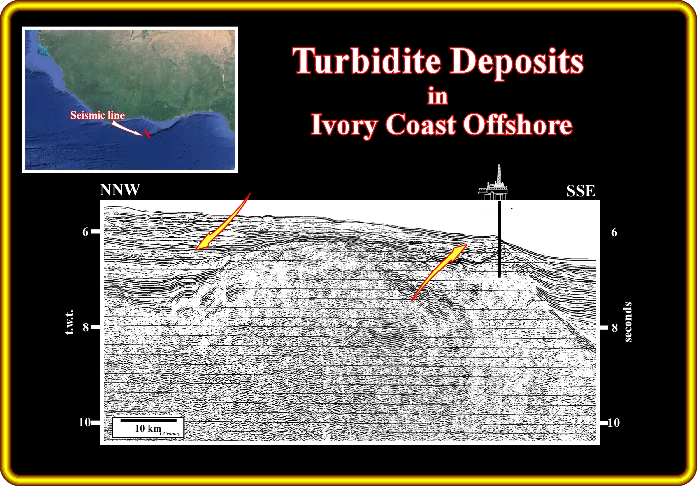
On this seismic line of the Ivory Coast offshore, located slightly westward of that illustrated on the previous plate, the structural high between two major fracture zones is obvious, as well as the turbidite deposits within the Tertiary sedimentary interval. The vertical geometry of the turbidite deposits is easily recognized above each major relative sea level fall : (i) Lenticular lobate, at the bottom, with, more or less, continuous, reflectors and (ii) Hummocky at the top, in which channel-levee complexes,i.e., where gully-wings are predominant. The lenticular geometry can be considered as equivalent to the basin floor fans of P. Vail, while the hummocky geometry can be considered as slope fans. The development of the slope fans is quite important and interesting as illustrated by the seismic lines of the next plates.
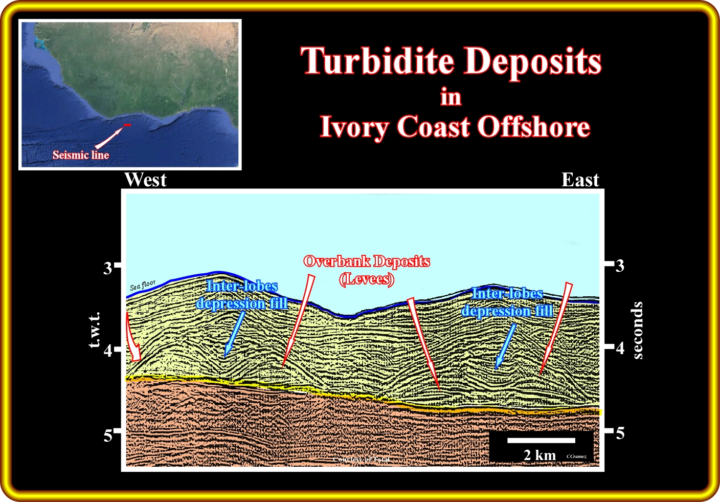
On this detail of a seismic line of the Ivory Coast offshore, channel-levees complexes, known often as gully wing, in the macroscopic Vail's turbidite model or as constructive aggradation phase in other models, are quite evident. Also, this seismic line strongly suggest that there is no erosion at the base of the channel-levee complexes and that its construction aggradation can be easily explained. In fact, the depression (often called, erroneously, channel) between the pristine lateral lobes is enhanced by the deposition of successive overbank deposits, which guide or canalize younger turbidite currents. On the other hand, is quite obvious that the sediments infilling the interlobes depressions are much younger than the sediments forming the overbanks. When the sediments infilling the depression is shaly the upper limit has a concave geometry is concave. On the contrary, when the infilling sediments are sandy, the geometry of the upper limit of the infilling is convex (by differential compaction). Generally, these turbidite deposits, which are often individualized by pelagic drapes and, particularly, overbank deposits, are shaly. Just few thin sand layers are found within the levees (overbank deposits).
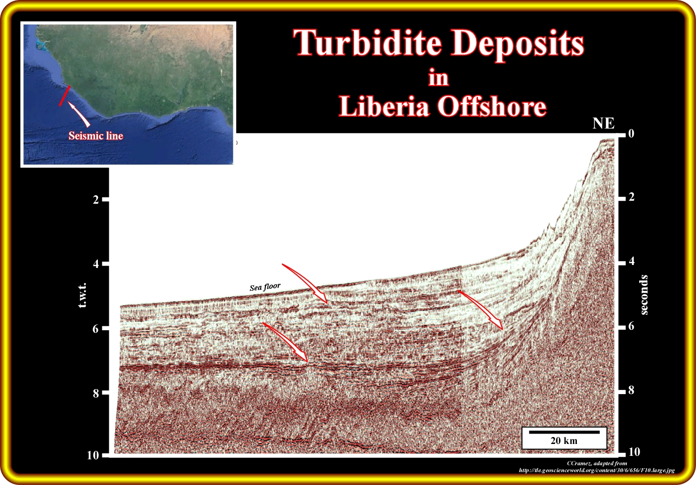
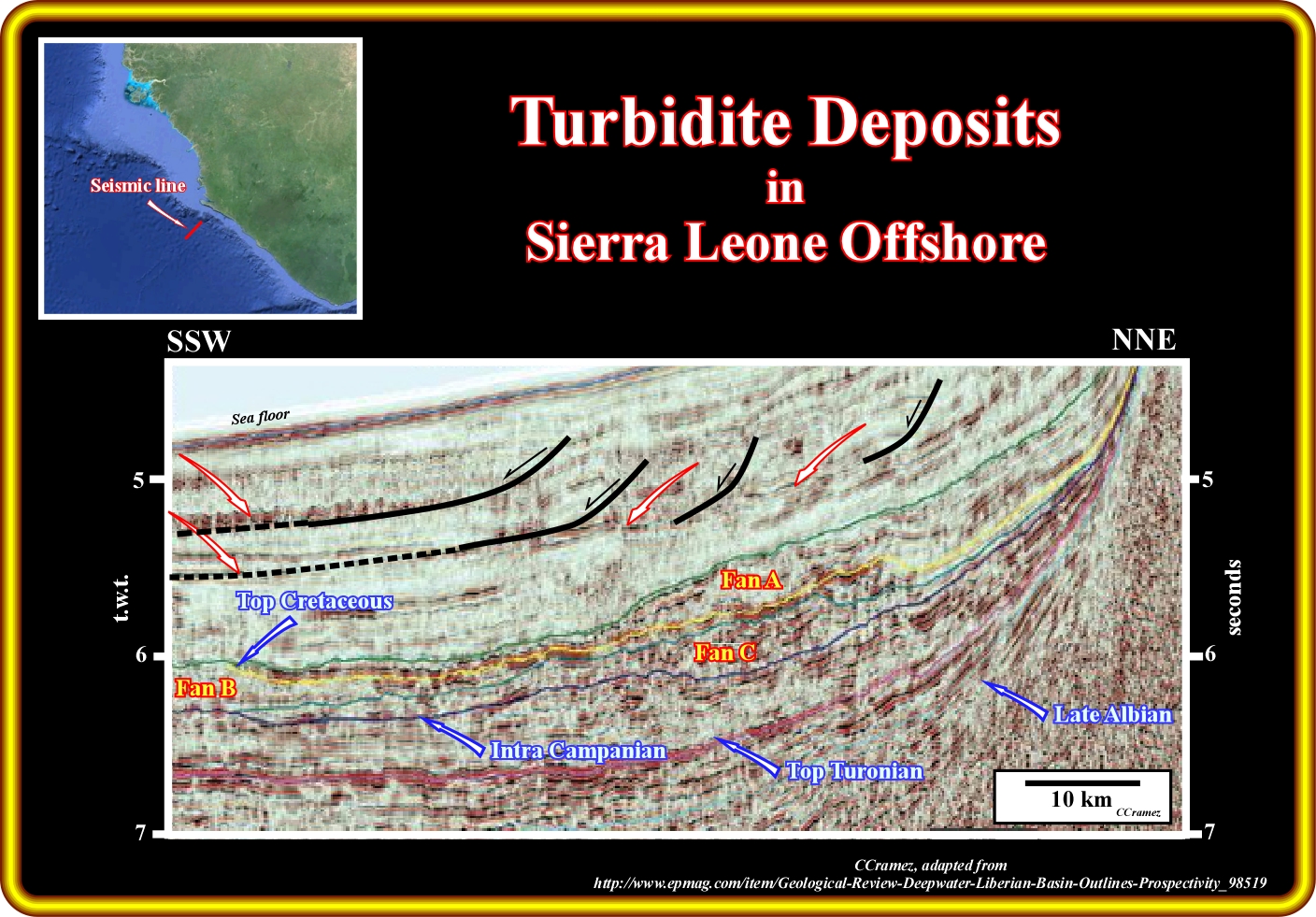
This plate illustrates a typical regional seismic line from the deep water Liberia offshore (the continental platform of this offshore is relatively small, no more than 100 km), in which above the Late-Albian unconformity, one can find Cretaceous turbidite deposits onlapping seismic surfaces underlying the unconformities (induced by relative sea level falls), bounding the principal continental encroachment stratigraphic cycles. In addition, Tertiary turbidite deposits associated upper slope-shelf failures (visible in the middle-upper continental slope) are, also, easily recognized. The geology of this offshore is similar to that of the Sierra Leone, which is depict on next plate.
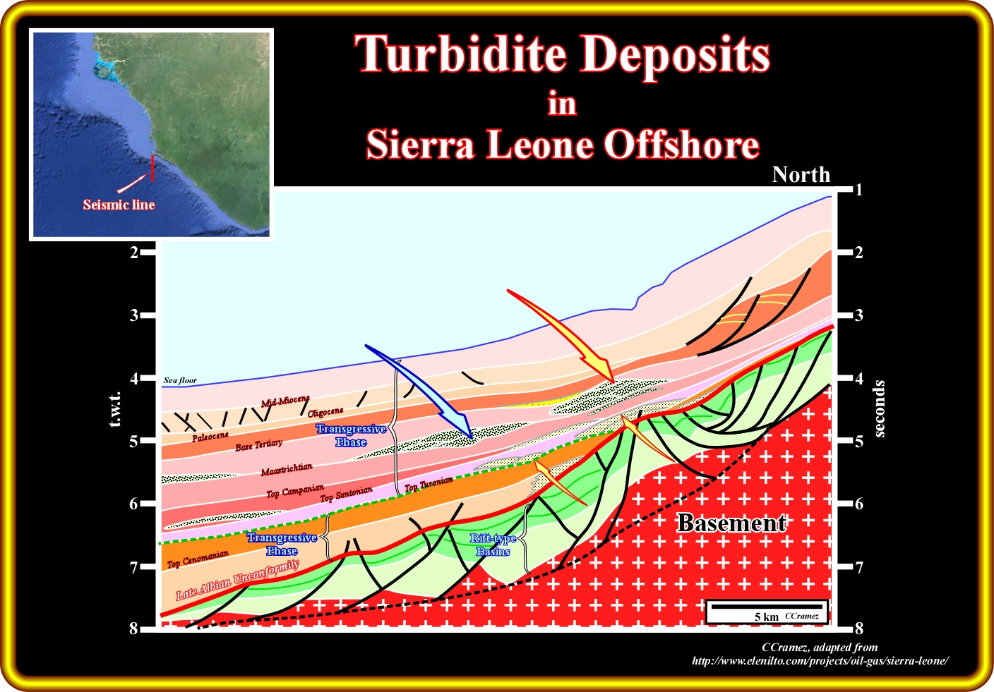
The geology and the more likely location of the main Cretaceous turbidite deposits of the Sierra Leone deep offshore are illustrated on this plate and can be summarized as follows : (i) Above a basement, which probably corresponds to a Paleozoic fold belt ; (ii) Lower Cretaceous rift-type basins developed, with a typical half-graben geometry, in response to the lengthening of the Gondwana lithosphere ; (iii) After the breakup of the lithosphere, more or less, in the Late-Albian, transgressive shallow water sediments were deposited during the Cenomanian-Turonian, i.e.,, during the rising of the global eustatic sea ; (iv) Since the global (eustatic) sea level started to fall, the sediments of the regressive phase of the post-Gondwana continental encroachment stratigraphic cycle begin to depose ; (v) During the Cretaceous time of this stratigraphic regressive phase, turbidite deposits were emplaced each time a relative sea level fall put the sea level under the shelf break or Continental break ; (vi) During the Tertiary turbidite currents were triggered in associated with slope-shelf failures and landslides.
On this geological tentative interpretation of a seismic line of Sierra Leone, potential Cretaceous turbidite deposits are easily recognized above the Turonian downlap surface (probably, the MFS. 91.5 Ma, i.e. the maximum flooding surface of age 91.5 millions years ago) in association with the major updip unconformities, which are here (deepwater) represented by their correlative deepwater conformities, since significant erosion is absent. On the other hand, Tertiary turbidite deposits are likely in association with slope/shelf failures, slumpings and landslides, well distinguished on this seismic line.
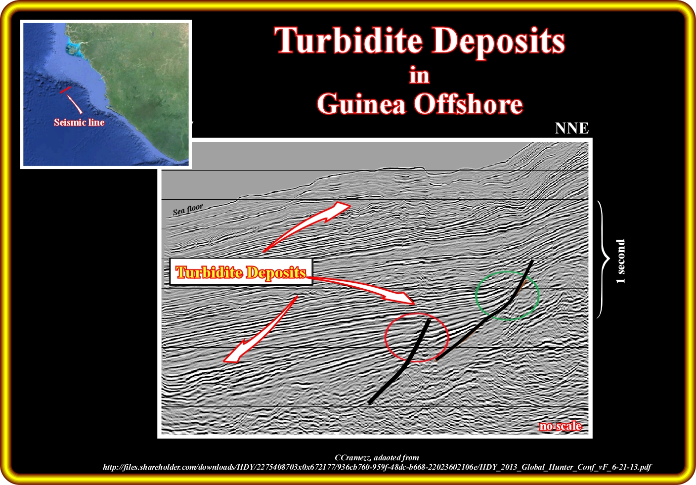
Geoscientists, knowing the geology of Guinea or of Guinea Bissau Offshore (see next plate), easily recognize decubitus deposits on this close-up of a seismic line of the Guinea offshore (due to confidentiality reasons the location is approximative and the horizontal scale omitted). Immediately below the sea floor, an hummocky turbidite interval was deposited above an well marked conformity, which correlates updip (where erosion is visible) with a sequence-cycle boundary, that is to say, with an unconformity. The hummocky geometry suggests a stacking of slope fans (channel-levee complexes). As this line is parallel to terrigeneous influx (dip line), the gully-wings are not too evident. However, in a perpendicular line (strike line), their are more than evident. The lower turbidite deposits are Upper Cretaceous in age and often associated with the Senonian unconformity as better illustrated in the next plates, i.e., in Guinea-Bissau offshore.
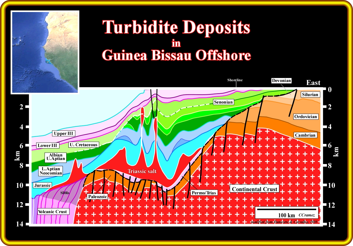
The geology of Guinea-Bissau (onshore and offshore) is illustrated on this geological cross-section, which is based on a composite seismic profile. The Gondwana is here represented by a Precambrian basement (pristine continental crust) and Paleozoic sediments, which form the infrastructure of the Ceno-Mesozoic divergent margin and associated underlying rift-type basins. Immediately after the break of the lithosphere, took place a subaerial volcanic accretion, by deposition of lava flows (SDRs), over which the basal sediments of the margin were deposited, particularly, the Triassic salt layer, which brine was enriched in potash by spilitisation (mineral transformation and liberation by metasomatism induced by hydrothermal circulation) of the underlying volcanic material. Above the salt, was deposited the transgressive retrogradational (backstepping geometry) stratigraphic phase of the Post-Gondwana continental encroachment cycle, over which was deposited the regressive progradational stratigraphic phase of the same encroachment cycle. During the transgressive stratigraphic phase, the basin, seismically speaking, has a platform (shelf break was located far away and seaward of the shoreline). On the contrary, during the regressive phase, the basin has no shelf (continental breaks and shorelines were, more or less, coincident). The limit between these two stratigraphic phases is the major Upper Cretaceous downlap surface, which, here, seem to have a Senonian age. Consequently, theoretically speaking, turbidite deposits are likely in Mesozoic (highstand geological condition), seaward of the retrogradational shelf breaks, in association with slope and shelf instabilities and failures induced, mainly, by salt tectonics, and in Tertiary (lowstand geological condition) in association with relative sea levels falls.
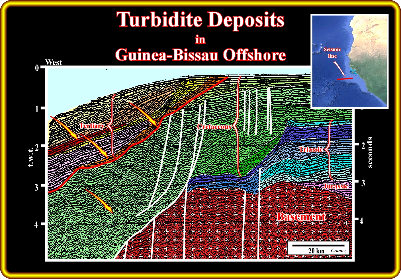
On this geological tentative interpretation of a regional seismic line of the Guinea-Bissau offshore, the more likely locations of turbidites deposits are : (i) Seaward of the last Jurassic shelf break, which is underlined by a reefal construction (such a turbidite deposits have probably a limestone facies) ; (ii) Seaward of the Cretaceous slope and shelf failures, which are highlighted by curvilinear normal faults and, in the Tertiary (iii) In association with the significant relative sea level falls that put the sea level below the shelf break (lowstand geological conditions), as well as at the bottom of the progradation of the lowstand prograding wedge (shingled turbidites) induced by turbidite currents triggered by upper slope and shelf break instabilities and flush floods.
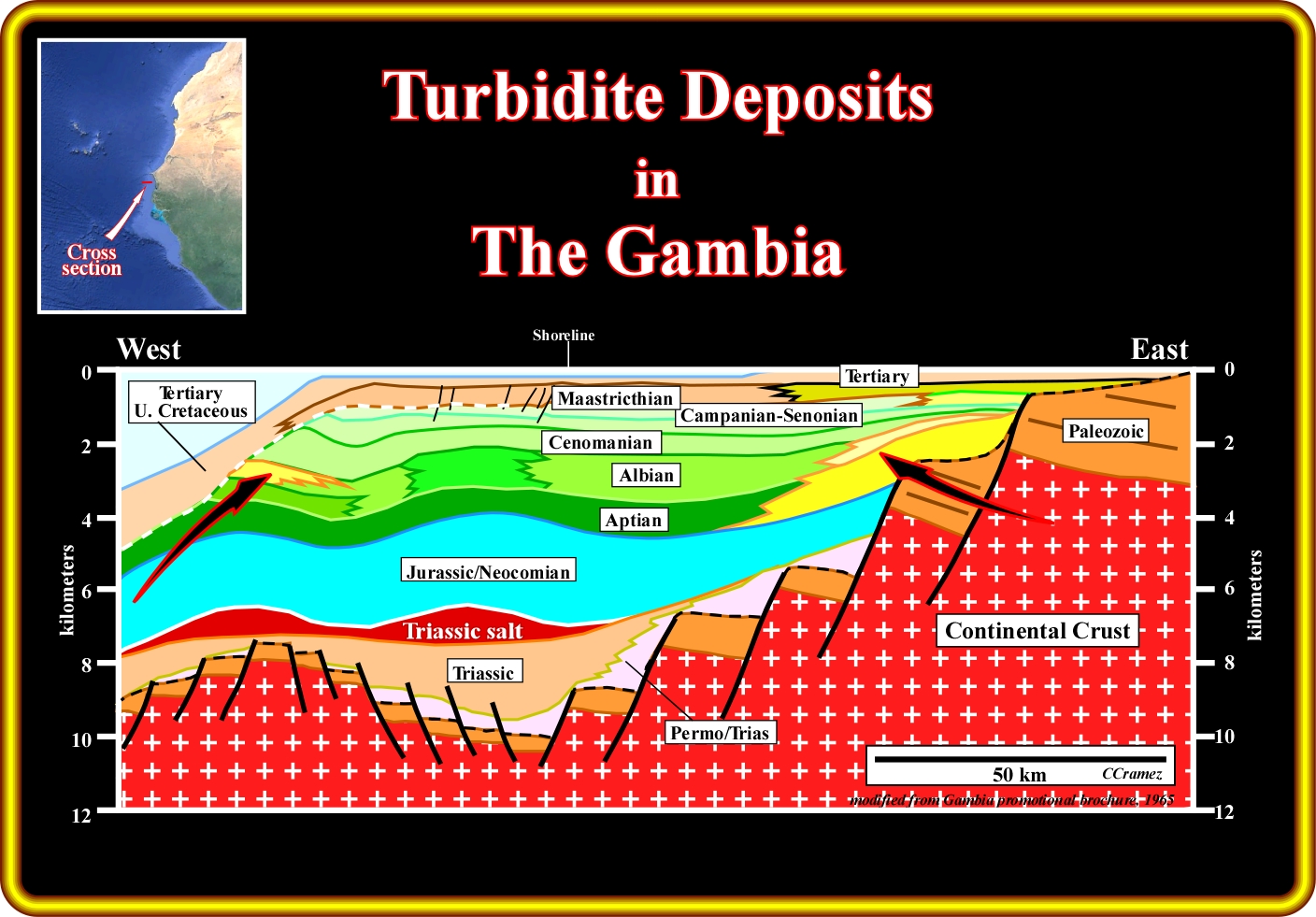
As depicted on this geological cross-section of The Gambia onshore and offshore, the geology of The Gambia offshore is very similar to that of the Guinea Bissau offshore and so, the more likely location of the turbidite deposits is, more or less, the same, i.e., : (i) Seaward of the last Jurassic shelf break, which, often is highlighted by a reefal construction (turbidites with a limestone facies) ; (ii) Seaward of the Cretaceous slope and shelf failures, which, locally, can be underlined by normal faulting normal faults and, in the Tertiary (iii) In association with the significant relative sea level falls that put the sea level below the shelf break (lowstand geological conditions).
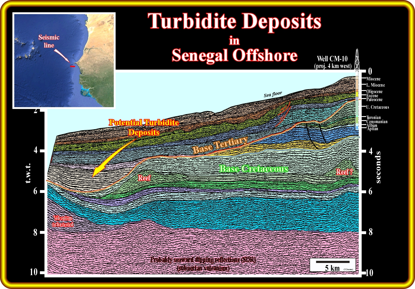
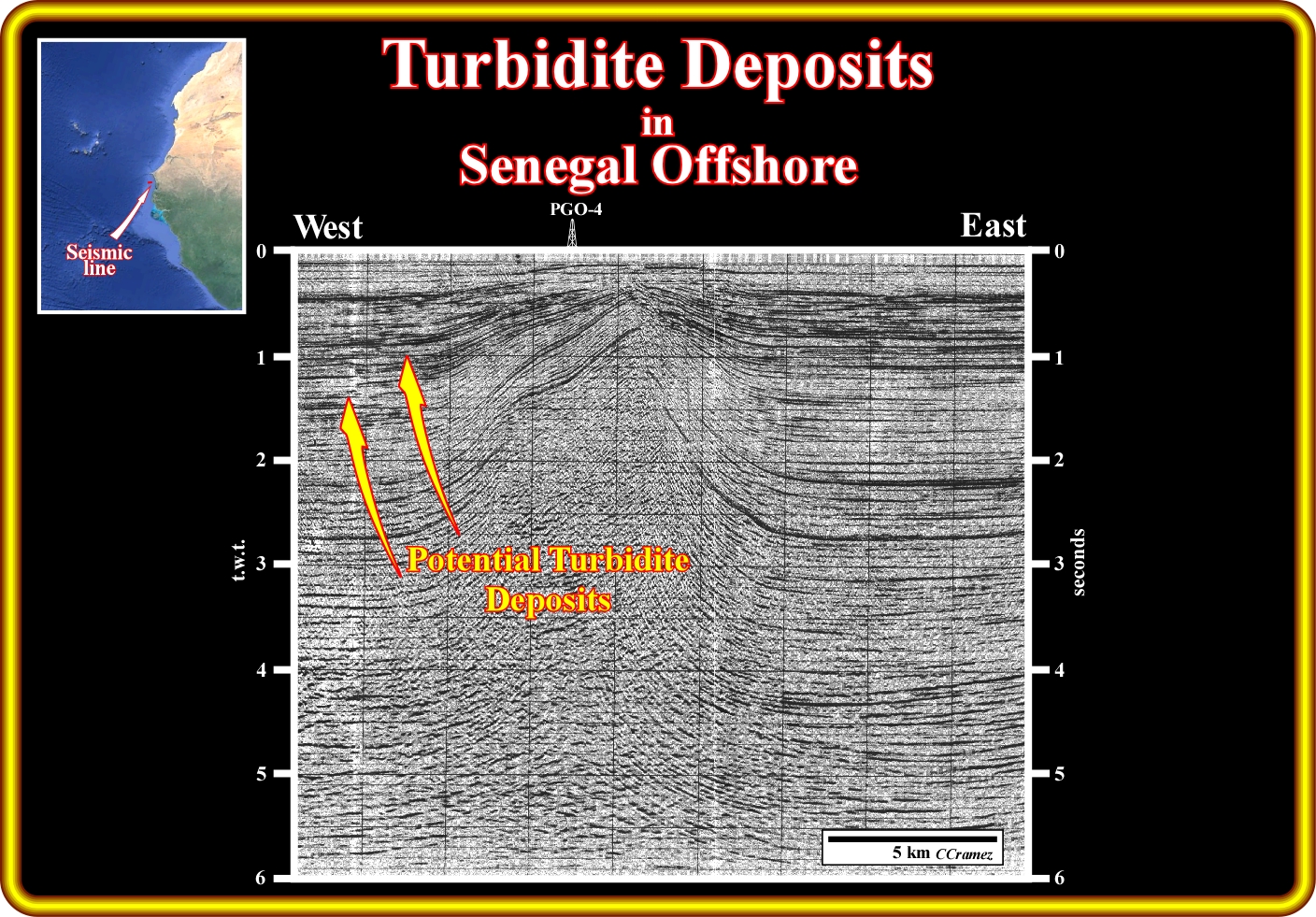
This geological interpretation of a seismic line of the Senegal deep water offshore strongly suggests that turbidite deposits are likely along the Base Tertiary unconformity, particularly, seaward of the Jurassic reefal carbonate anomaly. In fact, as illustrated on this tentative interpretation, the erosion induced by the relative sea level fall that took place at the top Cretaceous (Base Tertiary unconformity) strongly increase the terrigeneous influx which flow down to slope by gravity currents (turbidite currents). In the Middle-Upper Tertiary slope-shelf failure and slumpings, suggested by curvilinear normal faults, can induce turbidite sediments in the Middle-Upper part of the continental slope.
This seismic line of the Senegal conventional offshore suggests the possibility of turbidite deposits in association with the salt tectonics, particularly with sedimentary failures and landslides in the flanks of the salt domes. Such a potential turbidite deposits are not associated with relative sea level falls, since the salt diapirs rarely reach the sea level, that is to say, rarely induce an erosional surface.
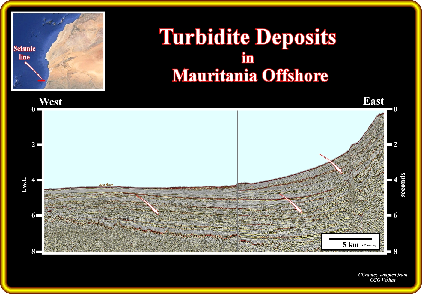
This seismic line from the Mauritania offshore, shows that the more likely location of Cretaceous turbidite deposits is landward of the shelf break, in onlap against the major Cenomanian-Turonian downlap surface MFS. 91.5 Ma, that is to say, against the maximum flooding surface of age 91.5 million years ago, while the Tertiary turbidite deposits (Miocene and Pliocene) are located seaward of deepest inclination break of the unconformities or associated correlative deepwater conformities. Such a turbidite deposits are often disconnected of the lower continental slope break.
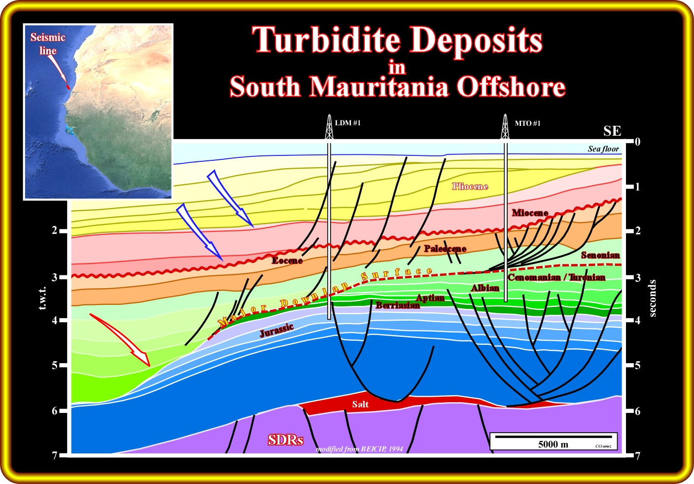
This geological tentative interpretation of a seismic line from the South Mauritania offshore, is typical of the South Atlantic margins and shows clear similitudes of the lines of the offshore East Coast (USA). Indeed, it unmistakably illustrates the two major stratigraphic phases of the Post-Pangea continental encroachment cycle. The downlap surface between the stratigraphic phases separates sediments with a backstepping geometry from overlying sediments which have a forestepping geometry. This major downlap surface, which age is, more or less, Cenomanian-Turonian (MFS. 91,5 Ma) underlines the more likely location of conventional marine source rocks, in spite of the fact, that within the transgressive stratigraphic phase, Jurassic marine source-rocks can not be excluded. Concerning the more likely location of the turbidite deposits, one can say that the Cretaceous turbidites, probably of Senonian age, are above the Jurassic condensed stratigraphic section, while the Tertiary turbidity sediments, as usually, are likely onlapping against the major unconformities and at the toe of the slope Pliocene progradations.
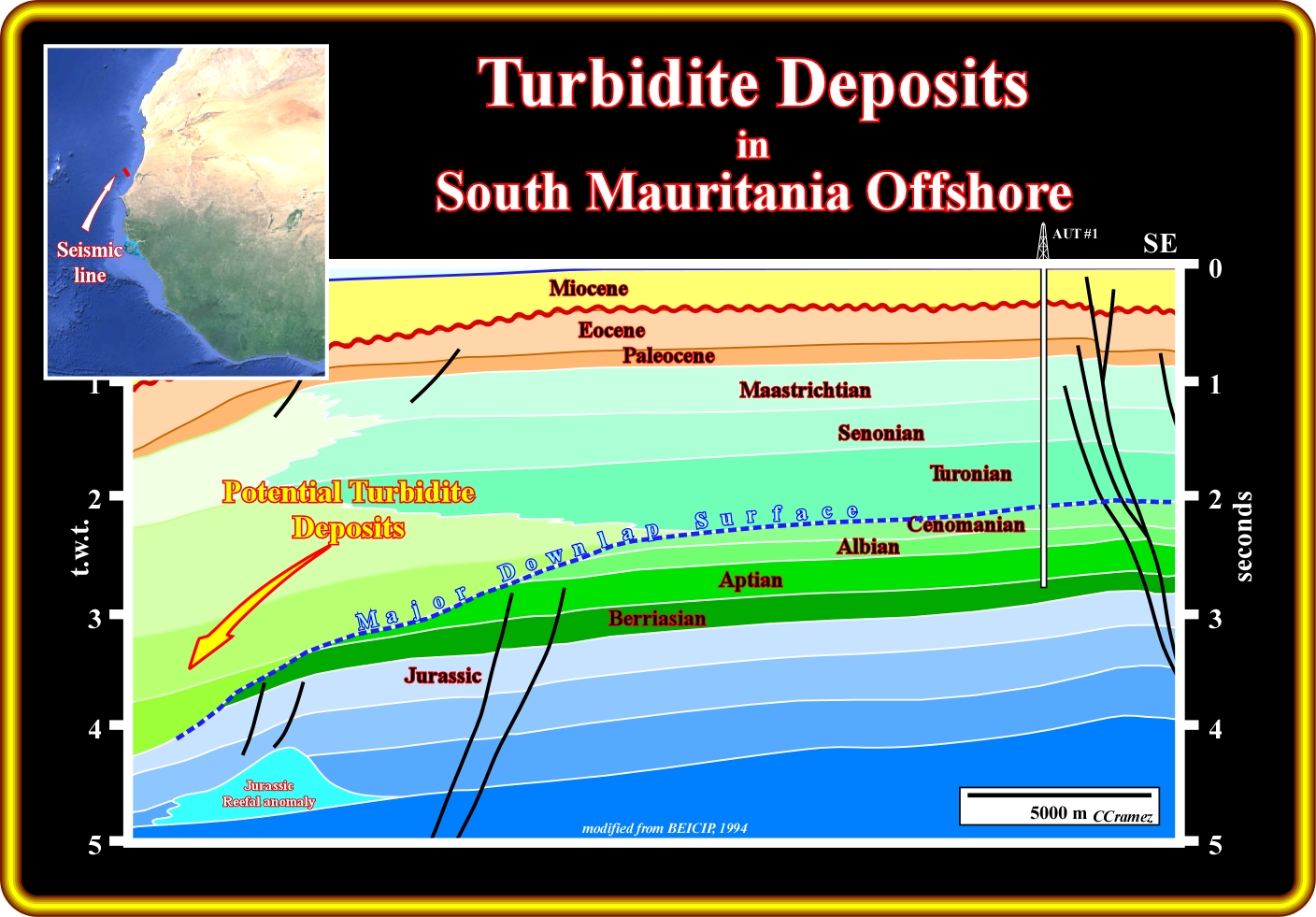
This geological tentative interpretation of a seismic line of the Mauritania offshore, located slightly landward of the previous one, depicts quite well the seismic stratigraphy of the margin, in which the transgressive retrogradation stratigraphic phase and the regressive forestepping phase of the post-Pangea continental encroachment cycle. Notice an important sea level fall at the base Miocene, with which turbidite deposits are likely in deeper part of the margin, as well as a relatively marked relative sea level fall at top Senonian. Significant turbidite deposits are likely onlapping the distal segment of the major downlap surface (Cenomanian-Turonian), just above the Jurassic condensed Jurassic (seaward of the reefal Jurassic stratigraphic anomaly).
No data
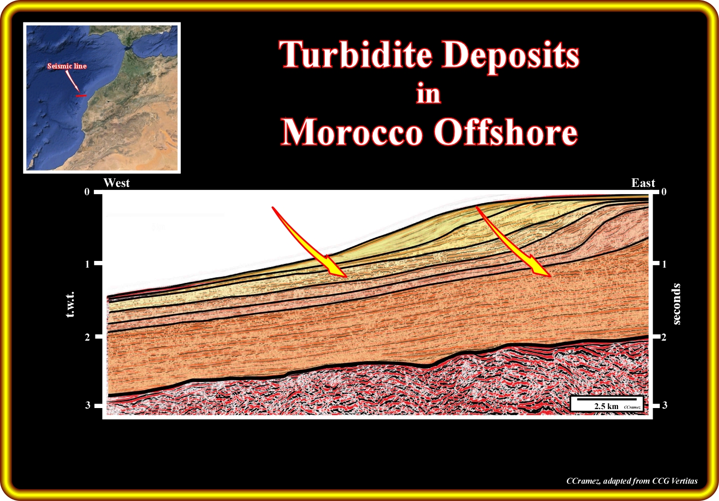
On this geological tentative interpretation of a seismic line of Morocco offshore, shot in, in a area where evaporitic layers are absent and the sediments are, more or less, undeformed, one can easily prognosticate the more likely location of the turbidite deposits, at least for the first five upper packages, In fact each sedimentary package is bounded by unconformities, in the shelf and upper slope, and by their deepwater correlative conformities in the middle-lower slope and abyssal plain, where erosion, when present, is meaningless. In other words, these upper turbidite deposits are associated with significative relative sea level falls, that put the sea level below the shelf break (lowstand geological conditions), which are the main cause for the formation of the turbidite currents down slope, which transport to the basin the terrigeneous influx discharged directly on the upper slope. In the lowermost sedimentary package, turbidite deposits area plausible. However, their location is difficult to determine, since the recognition of the stratigraphic cycle boundaries is practically impossible. In relation to this lower interval, the seismic line is too distal. The updid unconformities (in upper slope and shelf) are not visible, which prevent to the recognition of their deepwater correlative conformities.
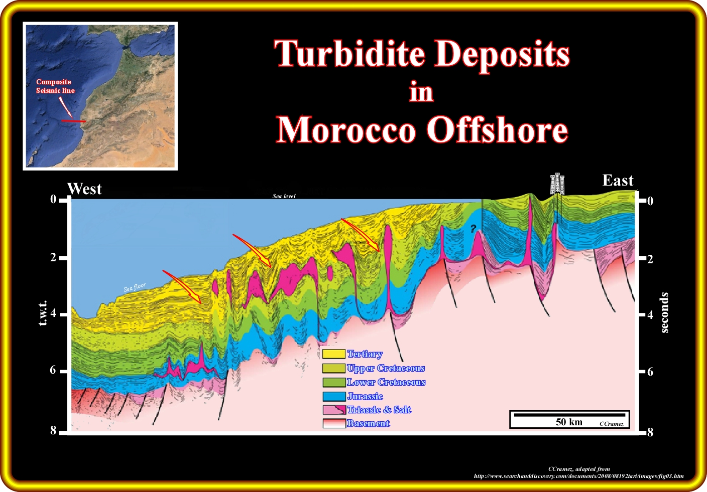
In the areas of Morocco offshore where Triassic evaporites were deposited, as illustrated on this geological tentative interpretation, turbidite deposits are likely in the Upper Cretaceous and Tertiary in association with the halokinesis of the allochthonous salt layer In fact, the upward movement of the salt layers, and particularly the allochthonous layer, uplift and lengthened the sediments of the overburden by normal faults, which can create instabilities and landslides between the salt structures triggering turbidite currents and causing the deposition of turbidites, mainly during highstand geological conditions, that is to say, with the sea level higher than the shelf break.
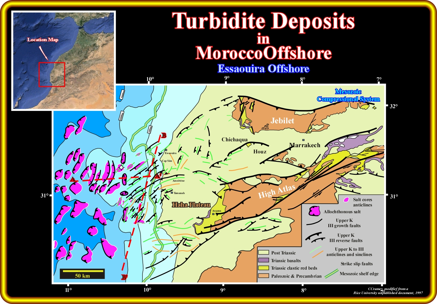
On this schematic geological map and particularly westward of the Mesozoic shelf wedge, in the Eassaouira offshore, between the Triassic allochthonous salt (salt layer overlying part of its overburden, i.e., a sheet like salt body tectonically emplaced at stratigraphic levels overlying the autochthonous salt layer, lying within stratigraphically younger strata), Tertiary turbidite deposits are likely, as illustrated on the seismic lines ( A-A' and B-B') depicted on next plates.

On this geological tentative interpretation of the North-South seismic line of the Essaouira offshore (see location on the previous plate, line A-A'), it is easy to recognize that the sediments (autochthonous salt layer included) were shortened by folds and reverse faults, which favour a late upward movement of the Triassic salt layer (halokinesis), creating condition for the development of turbidite currents and associated turbidite deposits. In addition to these turbidite deposits, formed during highstand geological conditions, following more the Mutti's turbidite model rather the Vail's turbidite model, in which relative sea level falls are the main driving mechanism, other turbidite deposits formed during lowstand geological conditions are probable in the uppermost stratigraphic intervals as illustrated on the next seismic lines.
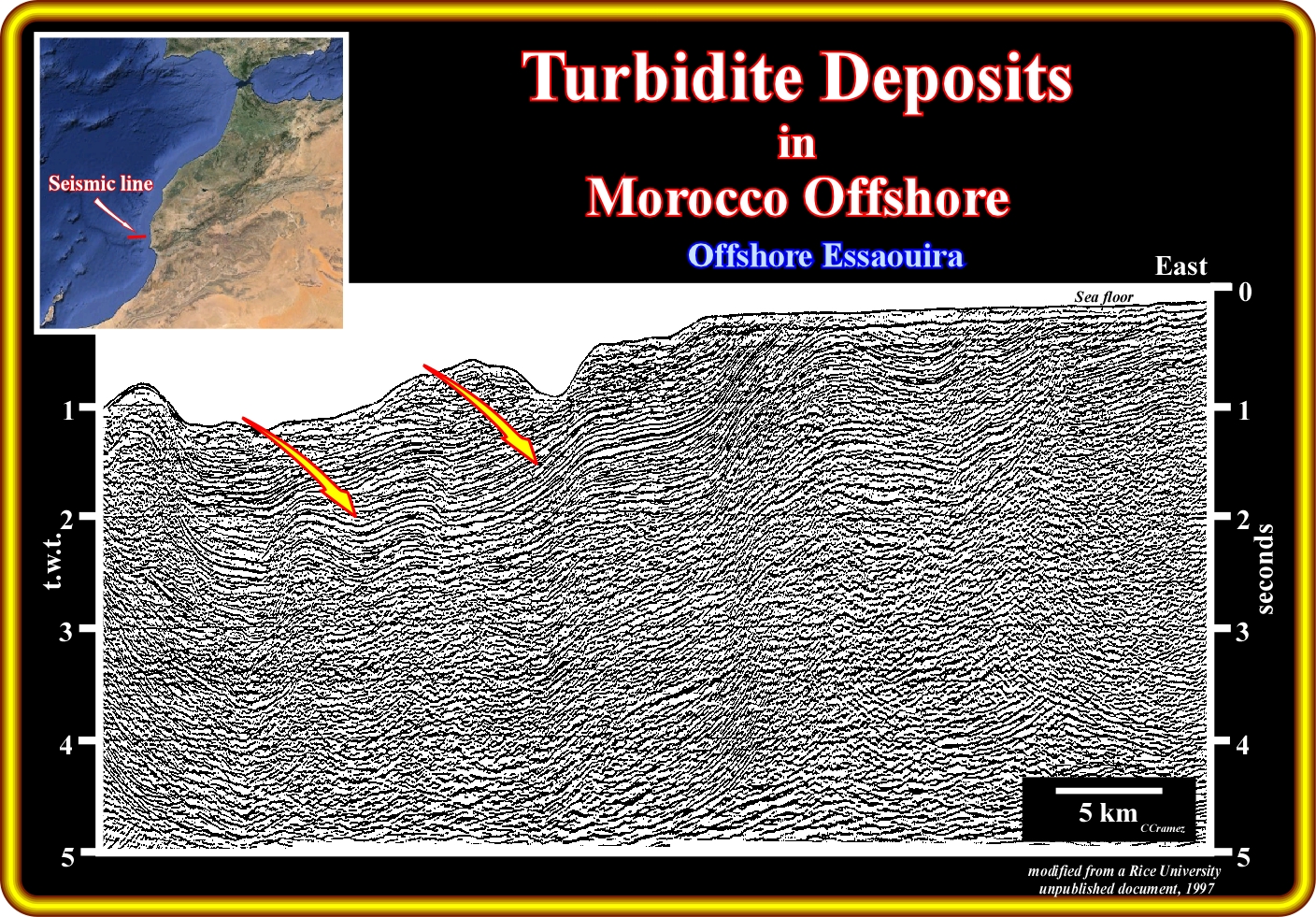
On this strike line of the Essaouira offshore (see location on before last plate, line A-A'), turbidite deposits associated with significant relative sea level falls. These sea level falls put the sea level below the shelf break, which strongly favoured the formation of turbidite currents transporting the excessive terrigeneous influx down to the slope and abyssal plain where it was deposed basin floor and slope fans.
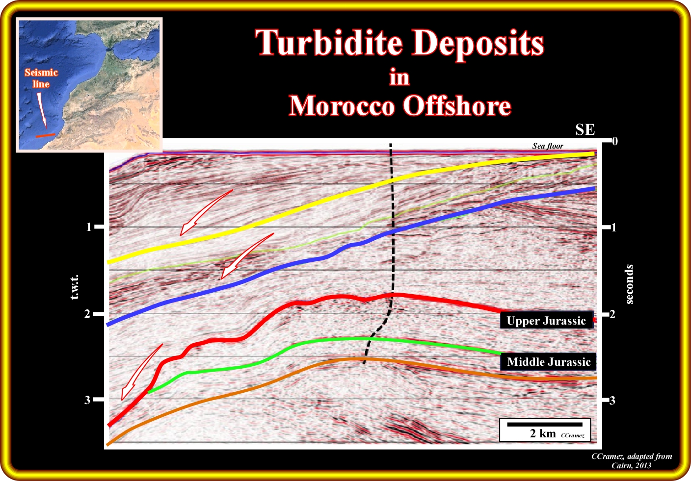
Conventionally, as illustrated on this seismic line from Morocco offshore by the location have a forthcoming exploration well, the main target in petroleum exploration still are the Middle-Upper Jurassic carbonates, particularly the reefal construction. However, as one can observe (do not forget that to observe something you need to know, a priori, what you must observe) on this seismic line, potential turbidite deposits onlap the three tectonically enhanced unconformities (angular unconformities) coloured in red, blue and yellow.
to continue press
![]()
Send E-mail to carloscramez@gmail.com with critics, corrections or commentaries on these Turbidite Deposits notes.
Copyright © 2001CCramez
Last modification : November, 2013