II) Turbidite Models
Several papers and books described, discussed, explained and proposed classifications of the turbidite systems taking into account processes, facies, internal geometries (e.g., Bouma et al., 1985; Mutti & Normak, 1987; Pickering et al., 1989; Mutti & Normark, 1991; Weimer and Link, 1991; Mutti, 1992; Weimar et al., 1994, Mutti et al., 1994; Reading and Richard, 1994; Shanmugam, 1999; Mutti et al., 2000) and genetic signification of deep sea deposition systems (e.g., Mitchum et al., 1985; Stow et al., 1985; Mutti, 1985; Vail, 1987; Mutti et al., 1988, Posamentier et al., 1988; Pickering et al., 1989; Posamentier et al., 1991; Normark et al., 1993; Mulder and Syvitski, 1995; Mutti et al., 1996; Normark et al., 1998).
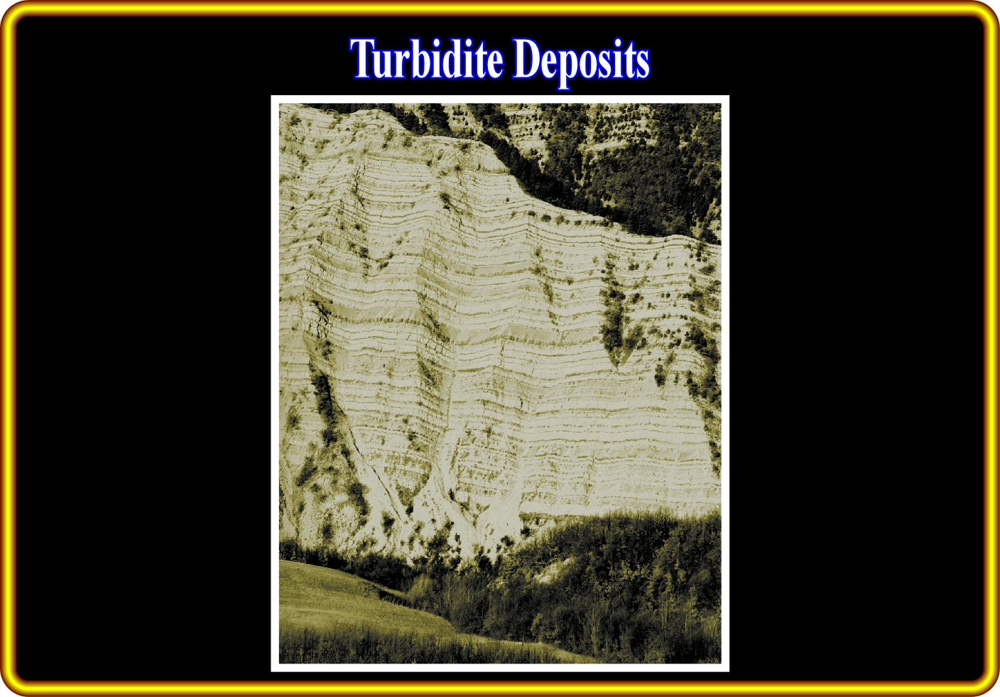
In this outcrop (Late Cretaceous Monte Cassio flysch in Northern Apennines), the horizontal beds correspond to parallel bedded basin-plain deposits. They are, mainly, redeposited pelagic and hemi-pelagic biogenic oozoes. Subordinate, fine-grained sandstone form the darker and considerably thinner beds (more resistant sedimentary units). These sediments, which are interpreted as trench-fill deposits are thought to be a classic example of stacked mega-turbidites deposited from gravity currents triggered by seismic activity (seismo-turbidites of Mutti et al., 1984), The thin bedded sandstones and the dark mudstones represent the background sedimentation of the basin plain.
Today, 50 years after that Kuenen and Migliorini interpreted the graded bedding observed in main ancient flysch deposits as a result of turbidity currents (see Kuenen and Migliorini, 1950), and 30 years after the first models of submarine fans (see Normark, 1970; Mutti and Ricci Lucchi, 1972), the number of models (frequently mixing subsurface and outcrops-derived data) approach the number of turbidite systems studied (situation already anticipated by Normark in 1993). For several geoscientists (and for many geologist / geophysicist of oil companies) such a situation is firstly related to the fact that a great part of the present day knowledge on turbidites still coming from deep-marine succession deposed in ancient episutural and perisutural basins.
- If some turbidite fans still are active today (La Jolla, Magdalena, Crati, etc.), the Holocene sea level rise has deactivated most of them, which are now being veneered with mud rendering impossible comparisons between ancient and modern turbidite systems.
- It is impossible to directly reason in depositional contexts and their functioning. Depositional events are episodic at geological scale, but they surpass by several the times human time scale.
- In the last years, following the discoveries in Tertiary turbidites in Gulf of Guinea, the interest of the oil companies has been focused on the slope systems that have been considered, for long time, deprived of economic potential.
- These deposits are mainly associated with large deltaic systems developed in the central part of South Atlantic margin.
- Apparently, in terms of external geometry, they show strong similarity with the modern sedimentation.
- Several studies (side-scan sonography, narrow sea-beam bathymetry, high resolution seismic, sea bottom coring, etc.) of the modern sedimentation of Gulf of Guinea deep sea fans have been lanced in the last years.
- Despite the profuse efforts of modelling, the internal geometries, facies distribution and lateral variations of reservoirs associated to this type of deposits still are unforeseeable.
- Curiously, in order to get a better comprehension of these modern depositional systems, geoscientists return again to the study of the outcrops. A kind of back to origins to understand the genesis, geometries and facies associations of the turbidite deposits that, in the field of the stratigraphy and sedimentology, still are too enigmatic.
- It is evident that systems with large variability, like turbidite systems, are complexes and cannot be understood just by a reductionist approach, that is to say, in terms of the properties of simple building blocks.
The discovery of giant oil fields in deep offshore in offshore Brazil (Marlin, Albacora, Roncador, etc), characterized by sand deposits highly reworked or entirely deposited by bottom currents (Carminatti an Varela, 1987; Mutti, 1989; Mutti, 1992), again highlighted the apparent impossibility of comparison between the outcropping turbidite systems deposited in highly tectonically mobile basins (Pyrenees, Alps, Apennines, Neuquen, etc.), which are devoid of facies related to reworking by bottom currents or turbidite systems recognized by drilling in cratonic basins (North Sea) and in divergent margins (West Africa, Gulf of Mexico, etc.).
- At the present-day and during the Tertiary time, the continent-basin profile through Campos oil fields is strong different of the profiles across other margins (Gulf of Mexico, Congo, Pakistan, etc.).
- In contrast with these basins, characterized by large coastal plains and shelves with huge deltaic systems, in Campos basin only small deltaic systems are developed in a relatively short distance between the bay line and the shelf break.
- However, at Cretaceous time (mainly Upper Cretaceous), in Campos basin, the seismic lines and the exploration’s results suggest a very thick deep water wedge associated to a relatively thin platform sedimentary sequence.
- Conversely, in the other basins mentioned above, the Upper Cretaceous stratigraphic deep sections are very condensed and their facies is shaly.
Taking into account the possible causes of turbidite currents, it is an utopia to advance a unique model for explaining turbidite deposits. Three main turbidite geological models, proposed mainly by Vail (1977, 1989, 1991), Mutti (1977, 1992) and other geoscientists explain the majority of the turbidite deposits, particularly those recognized in petroleum exploration. Vail's turbidite model, primarily, explains turbidite deposits triggered by regional or global, relative sea level falls. Mutti's turbidite model explains those associated with large shelf-break slope slumps and catastrophic floods. A submarine upwelling erosion model (SUV model) explains certain turbidite oil fields in West Africa offshore, as Baudroie-Baliste, located in area without deltaic systems in the continental platform. However, one cannot forget that the Vail's turbidite model is, mainly, a macroscopic model (the scale of the geological maps and seismic lines) and put together almost, exclusively, on seismic data, which resolution is, generally, not less than 20-50 meters. On the contrary, the Mutti's turbidite model, is a mesoscopic model (outcropping scale) based, mainly, on field work. The submarine upwelling erosion model, as the Vail's model, is fundamentally based on seismic data.
Summing up, one can said that in Vail's, as well as, in the submarine upwelling erosion model, geoscientists progress from the general to the particular., while in Mutti's approach, they progress from the particular to the general. On the other hand, taking into account the scales at which the different models have been constructed, is obvious, that certain features of Mutti's model cannot be recognized on the Vail's model, due to the seismic resolution.
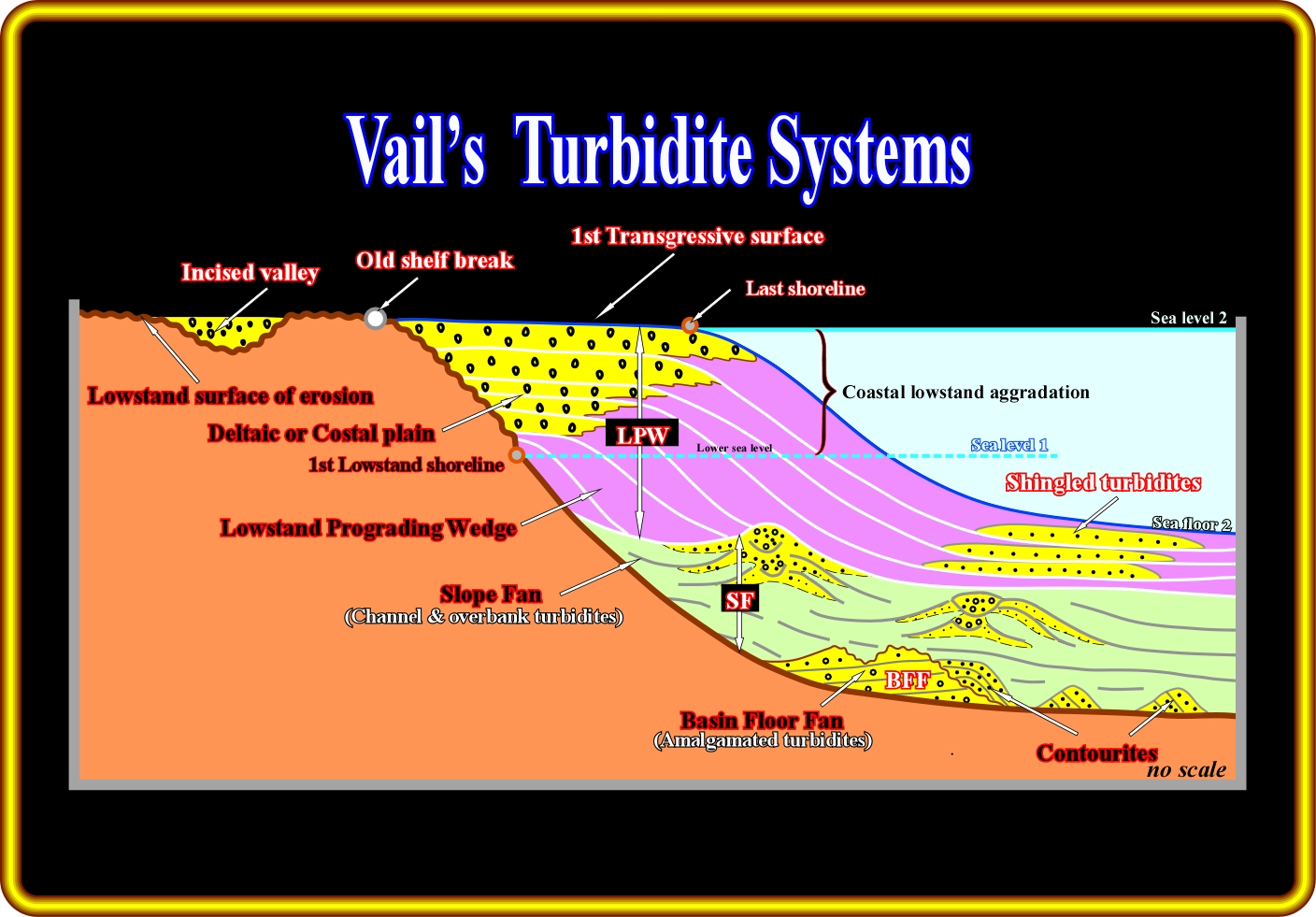
In a deep-water setting, that is to say, when the limit between the shelf break, or the depositional coastal break, and the continental slope is well marked, Vail's turbidite model can be illustrated as depicted on the above sketch. In fact, following a significant relative sea level fall (regional or global), the sea level falls below the shelf break and the continental platform (shelf) is exhumed. Therefore, the basin has no more platform (shelf). The depositional coastal break (roughly the shoreline) is displaced seaward of the old shelf break, creating regional, or global, lowstand geological conditions. Such a displacement disrupts the provisional equilibrium profile of the rivers, which are obliged to cut into the old sediments forming incised valleys in order to establish new provisional equilibrium profiles. Such erosion, created by a significant relative sea level fall, substantially increases the terrigeneous influx. The sediments are discharged on the upper part of the continental slope (the basin has no shelf) and trigger turbidity currents which transport the sediments downward to the deeper parts of the basin, where they are deposited as basin floor (BFF) or slope fans (SF). As the relative sea level starts rising, a lowstand prograding wedge (LPW) fossilizes the turbidite deposits. However, as the lowstand prograding wedge is deposited, instabilities on the upper slope or catastrophic flush floods, can create significant slumps of sandprone material, which will be deposed at the toe of the lowstand progradations forming what geoscientist call shingled turbidites.
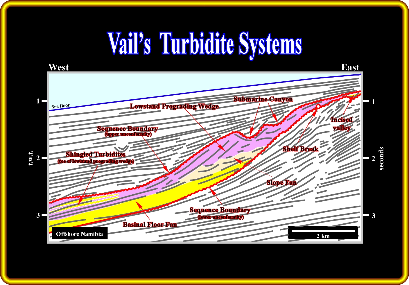
Admittedly, the tentative geological interpretations of the seismic lines of Namibia offshore, using the Vail's turbidite model (an a priori hypothesis), are more difficult to refute than the tentative geological interpretations grounded on Mutti's turbidite models. In Vail's model, eustasy and relative sea level falls are the major geological events that trigger turbidity currents and the associated depositional systems. Actually, as illustrated on this geological tentative interpretation, two consecutive relative sea level falls created two erosional surfaces, i.e., two unconformities (in red). These erosional surfaces are underlined not only by reflection terminations but also by incised valleys located in the uppermost part of the continental slope and in shelf. At each relative sea level fall, the sea level dropped below the shelf break, obliging the rivers to incise their beds to reach new provisional equilibrium profiles. Between two relative sea levels falls, that is to say, between two consecutive unconformities, as depicted, a 3rd order eustatic cycle (time duration between 0.5 My and 3-5 My) took place inducing a stratigraphic sequence-cycle. However, in this particular example, the sequence-cycle is incomplete. In fact, just the lowstand systems tract was deposited. The transgressive and highstand systems tracts are absent. The three members composing the lowstand systems tract are easily recognized by the geometry and reflection terminations. From the bottom to top, one can recognize : (i) Basin floor fan ; (ii) Slope fan and (iii) Lowstand Prograding Wedge with its associated shingled turbidites. Conversely, the absence of obvious slope failures and landslides coupled with a significant progradation (seaward displacement) of the shelf break and associated shelfal deposits apparently refutes the applicability of highstand Mutti's turbidite model in this area.
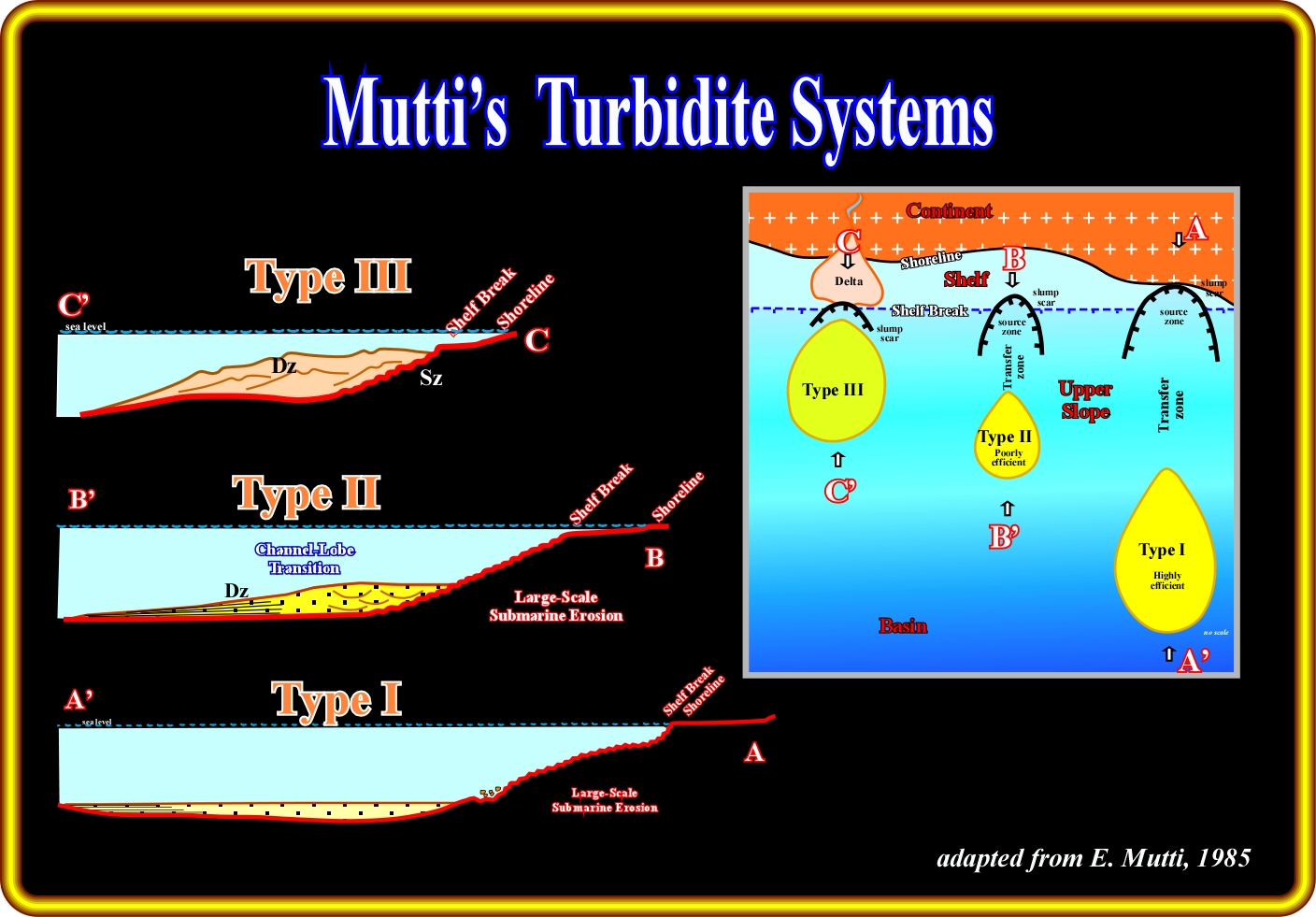
In Mutti's turbidite model, eustasy and relative sea level changes play an important role on turbidite deposition, but they are not essential for the development of the turbidite depositional systems. As pictured above, in Mutti considers three type of turbidite systems, mainly, function of the amount of material transported by the turbidite currents and the position of the sea level (highstand or lowstand). In type II (B-B') and type III (C-C'), turbidite deposition takes place in highstand geological situation, that is to say, when sea level cover the continental platform (shelf), which, in Vail's model is impossible. In fact, as said previously, in Vail's turbidite model, will will be described later, in detail, turbidite deposition requires a lowstand geological setting created by a relative sea level fall (combination of the eustasy with subsidence or uplift), in which eustasy is predominant. The Mutti's type I turbidite depositional systems developed in a geological context of lowstand, since, as illustrate above, the basin has no shelf. In fact, in this case, the shoreline and shelf break are, more or less, coincident. In Mutti's type I and II turbidite depositional systems, the turbidity currents are mainly triggered by significant slope failures and slumps, located near the limit between the upper slope and shelf. On the other hand, a paramount progradation of the shelf break, associated often with catastrophic flush floods, is often the onset of turbidity currents in Mutti's type III turbidite systems. Subsequently, a source area (seaward of a slump scar, for instance) and a transfer zone are often recognized updip of major turbidite depositional system.
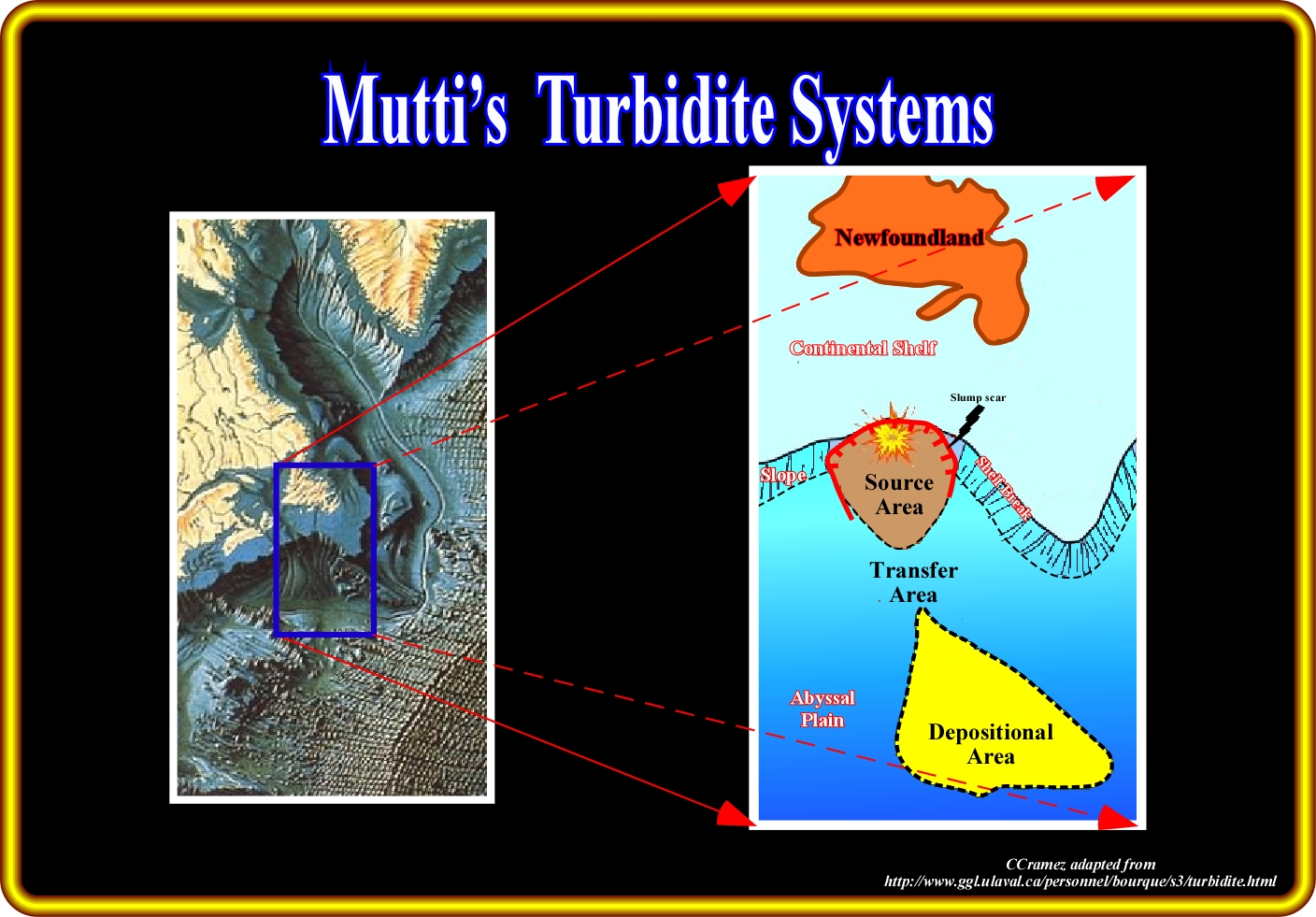
In certain cases, as illustrated here above (see also Introduction), slope failures are obvious, particularly when induced by an earthquake located near the shelf break. In fact, certain abyssal plain sedimentary anomalies cannot be explained by a turbidite deposition associated with a relative sea level fall (Vail's turbidite model). Mutti's turbidite model (in this particular example, a type I depositional system) explains better the sedimentary fan well defined on the abyssal plain and easily recognized in the morphological map of the sea floor. Similarly, as depicted on the geological tentative interpretation (sketch on the right), a slump of great magnitude, probably induced by an earthquake, triggered a significant turbidite current. The transported sediments were deposited on the abyssal plain, as soon as the turbidite current lost competence (maximum particle size that it is able to transport) and capacity (maximum load a current can transport). Such a tentative solution is corroborated by : (a) The slump scar ; (b) The transfer zone (often called talus or carpet) and (iii) The geometry of the fan itself, which is recognized without difficulty on the morphological map. It is quite evident that such a slump, which happened in 1929 (November 18), southward of Newfoundland (see Introduction), took place under highstand geological conditions (sea level above the shelf break). In other words, eustasy (Vail's turbidite model) did not played any role on the deposition of such a turbidite fan. Methodologically speaking, when a geoscientist recognizes, on the field or on a seismic line, a sedimentary anomaly on the continental slope or on the abyssal plain, attached or not at the toe of the continental slope, he must put forward, at least, two tentative solutions, one based on Vail's model and other grounded rather on Mutti's model. Afterwards, using all data available, he must criticize all tentative solutions and choose the more difficult to refutable. In fact, with time, all geological tentative interpretation will be refuted (falsified).
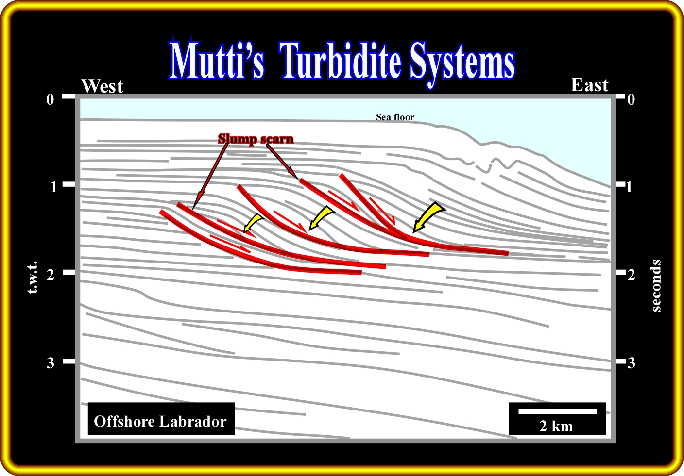
This plate illustrates an ingenious geological tentative interpretation of a seismic line from Labrador offshore (Canada), in which just the seismic reflectors and seismic surfaces (reflection terminations) are picked. However, sedimentary anomaly at the base of the progradation (continental slope) are easily reckoned. Theoretically, different tentative solutions can be put forward to explain the depicted geometry of seismic reflectors, particularly seaward of the successive shelf breaks. Such tentative solutions can be based either on Vail's or Mutti's models. However, those based on Vail's turbidite model do not resist to a mild critical test. In fact, all along the coastal plain (subhorizontal reflectors continentward of the s shelf breaks), there is no evidence of incised valleys and, in the upper continental slope, there is no evidence of submarine canyons. In other words, between 0.9 and 1.9 seconds (t.w.t.), there is no evidence of a significant relative sea level falls. Therefore, the hypothesis of a continuous significant regression (forestepping) with catastrophic floods and slope-shelf failures seems more likely. On the other hand, at five different time-periods, the continental slope is obviously underlined by strong seismic reflectors (under the red seismic surfaces), which look like slump scars suggesting gravity slumps triggered, probably, by catastrophic flush floods. In other words, taking into account the absence of evident regional erosional surfaces and the likelihood of large slumpings, the chosen tentative solution must be grounded, mainly, in Mutti's turbidite model. Nevertheless, this ingenuous geological tentative interpretation do not refute the probability of presence, along the continental slope, of rectilinear submarine valleys induced by upwelling submarine currents, which can be easily recognized on strike (transversal) seismic lines (see next plate).
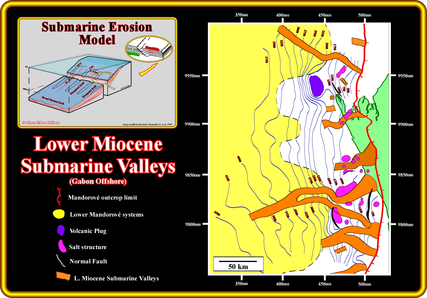
The map on the right of the south Gabon offshore shows several parallel submarine valleys oriented East-West on the middle-upper continental slope. Updip of these submarine valleys, in the continental platform (shelf), any deltaic depositional system is visible. Likely, that means that these valleys are not induced by relative sea level falls causing a seaward and basinward shift of the costal onlaps, i.e., by a downward and basinward erosion induced by the rupture of the provisional equilibrium profiles of the rivers. On the other hand, it is difficult to imagine a development of these valley from the top to the bottom, which is a normal development downdip of deltas. The more likely origin of such a parallel submarine valleys, more or less perpendicular to the shoreline, is a consequence of the Eckman transport which, as you see later, creates upwelling submarine currents (see sketch on the left), which erode, from the bottom to the top, the lower-middle continental slope. In the upper part of the continental slope, near de shelf break, such upward erosion can trigger turbidite currents which moving down slope can, partially, fill up the submarine valley or deposit the transported sediments on the bottom of the slope as turbidite lobes. In the map of the south Gabon offshore, illustrated above, any attention (a geoscientist recognize on a seismic line only what he knows and what he is looking for) was done to possible presence of distal turbidite deposits, that is to say, the above map cannot be used to refute the occurrence of turbidite fans disconnected from the continental slope (geological conjecture).
to continue press
![]()