Universidade Fernando Pessoa
Porto, Portugal
II- Tectonic Regimes & Volume Problems
As well as in the first part of these notes, here, again, our scientific attitude is that of K. Popper. It can easily be summarized as follows: I may be wrong and you can be right, and by an effort we may get near to the truth. It is bound up with the idea that everybody is liable to make mistakes, which may be found out by himself, or by others, or by himself with the assistance of the criticism of others - K. Popper (1945).
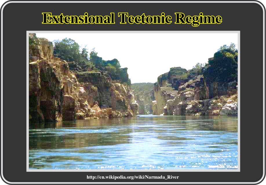
Fig. 98- The Narmada Valley is a graben, that is to say, a layered block of the earth‘s crust that dropped down relative to the blocks on either side due to ancient spreading of the earth’s crust. Two normal faults, known as the Narmada North fault and Narmada South fault, parallel the river‘s course, and mark the boundary between the Narmada block and the Vindhya and Satpura blocks or horsts which rose relative to the Narmada Graben. The Narmada’s watershed includes the northern slopes of the Satpuras, and the steep southern slope of the Vindhyas, but not the Vindhyan tableland, the streams from which flow into the Ganges and Yamuna. The Narmada valley is considered extremely important for paleontological studies in India. Several dinosaur fossils have been found in the area including Titanosaurus indicus found in 1877 by Richard Lydekker and the recently discovered Rajasaurus narmadensis.
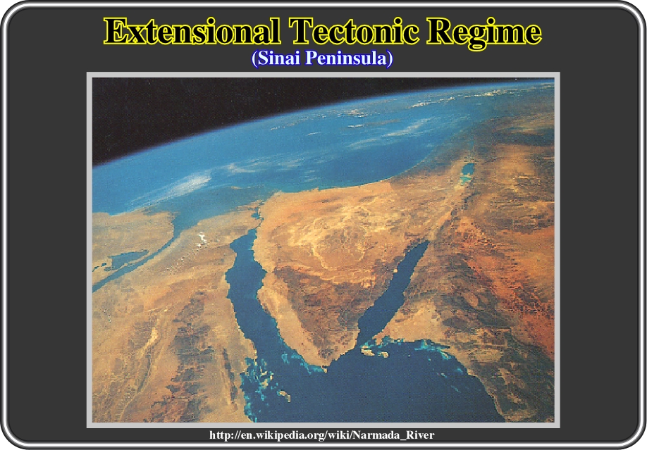
Fig. 99- Known by its strategic location and valuable deposits of manganese and petroleum, the Sinai Peninsula sits at the mouth of the Red Sea between the Gulf of Suez, to the west, and the Gulf of Aqaba, to the east. The Suez Canal lies at the northern end of the Gulf of Suez. Directly north of the Gulf of Aqaba is the Dead Sea, which contains no life and lies 392 m below sea level. It characterizes an area with predominant extensional tectonic regime with all extension structure associated. Two major geologic units comprise the Sinai. A sparsely vegetated limestone plateau that slopes downward toward the Mediterranean is shaded yellow. To the South, darker colours depict a mountainous region com-posed of igneous rocks that are sharply incised by deep, canonlike wadis, or dry streambeds (National Audubon Society, 1995).
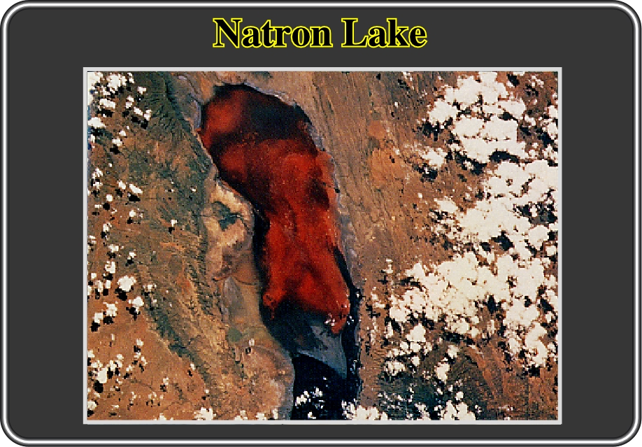
Fig. 100- Another area typically characterized by an extensional tectonic regime (s1 vertical) is the East Africa’s Great Rift Valley. This photograph illustrates Lake Natron, which is a lake rich in soda, or sodium carbonate. Two crustal plates pulling apart formed the Great Rift, which extends from Jordan in south-western Asia to Mozambique in south-eastern Africa. At low-lying areas, the rift has been filled in with water. The Dead and Red seas are two of such bodies. Blooms of various algae and the chemistry of the water, which has high concentration of sodium carbonate, cause the red colour of Lake Natron. The whitish spots seen in part of the lake are nearby carbonatite volcanoes, one at the northern end has a difference flow pattern from the rest, so it is clear of algae. Because of the lake’s unusual chemistry, few types of hundreds of thousands of pink flamingos, which feed on the abundant algae are found there. It spite of the fact that Lake Natron is the only known East African breeding ground for these birds, from a geological standpoint, it is a typical example of an extensional structure (see next).
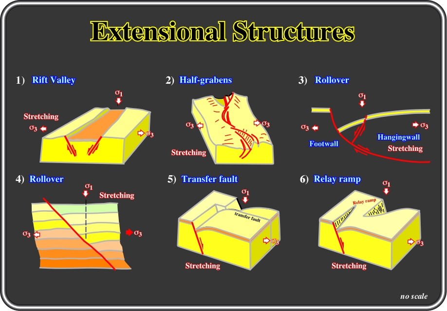
Fig. 101- During an extensional tectonic regime (
1 vertical), sediments are lengthened by normal faults. Extensional structures are created to respect Goguel’s law. Some of these structures were pictured by Hancock & Skinner (2000): 1) Rift Valley, framed by two inward-dipping faults roughly equal status along its entire length, where the plateau on either side of the rift slope away from it. 2) Half-grabens framed by a single major normal fault that switches sides as the graben is traced along its length. 3) Rollover that is to say, a half-graben bounded by a listric normal fault, which has given rise to a rollover antiform and an antithetic fault in its hangingwall. 4) A rollover antiform resulting from variations in the amount of displacement along a plane normal fault. 5) Transfer fault at a step-over within a normal fault. 6) A relay ramp at a step-over with a normal fault zone. In all extensional structures, Goguel’s law must be respected, i.e., geologists must propose coherent geological cross-sections, in which the sediments must accommodate to fill the volume gain by extension, since Nature does not accept empty space.
Nature hates void, that is to say, empty space created by extension. Therefore, in their interpretations, geologists must propose tentative solutions, in which all space, gained by extension, is filled by sediments but still preserving the volume of the sediments. In other words, the lengthening of the sediments must balance the space created by extension (potential voids). Summing up: under normal deformation conditions, either in compressional or extensional tectonic regimes, volume of sediments must be kept more or less constant.
C.2.1- Planar Normal Faults & Potential Void
Normal faults with a planar geometry (fault plane planar) are created to extend the sediments in order to fill the potential void (space gained by extension), as illustrated in fig. 102.
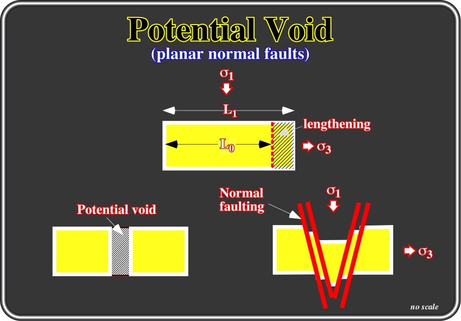
Fig. 102- In this sketch, theoretically, according to Goguel's law (preservation of volume during deformation), one can say that the lengthening of the sediments developed by the planar normal faults balances the potential void (space gained by extension). Indeed, as depicted, the original distance L0 is lengthened to L1. The space (here the area) created by lengthening must be filled by the original sediments, which must be lengthened by normal faulting (striking of the faults is parallel to 2) in order to avoid potential voids. Summing up: Geologists, in their tentative solutions (see fig. 103), must keep in mind the geological adaptation of conservation and energy principle, i.e. the total mass of any system is constant. In other words, they should not create, or destroy, sediments in their interpretations.
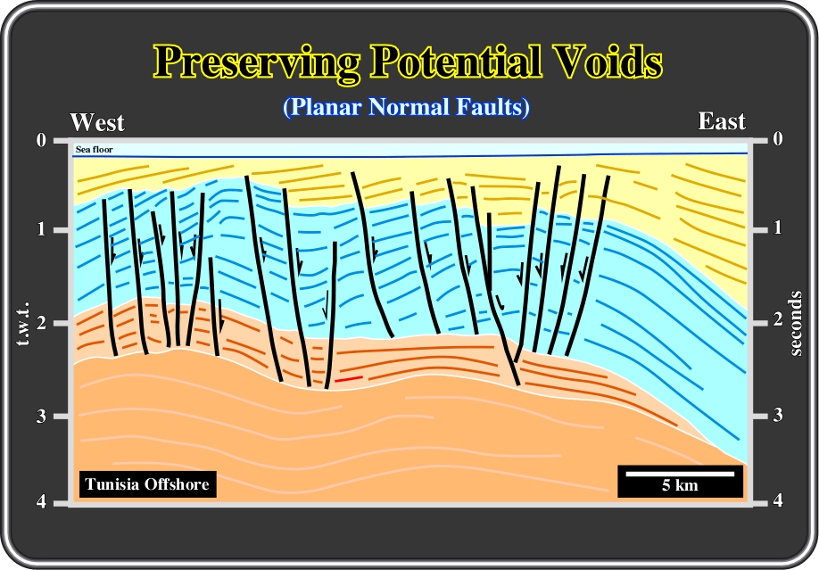
Fig. 103- In this interpretation of a seismic line from offshore Tunisia, planar normal faults, with opposite vergence, lengthened the sediments of the blue and light brown seismic intervals in order to fill the space created (potential void) by an extensional tectonic regime (
C.2.2- Curve Normal Faults & Potential Void
As normal faults with curved fault planes create potential voids between their faulted blocks, as illustrated in fig. 104, the sediments, mainly those forming the hangingwalls, must be lengthened to fill the space created by extension.
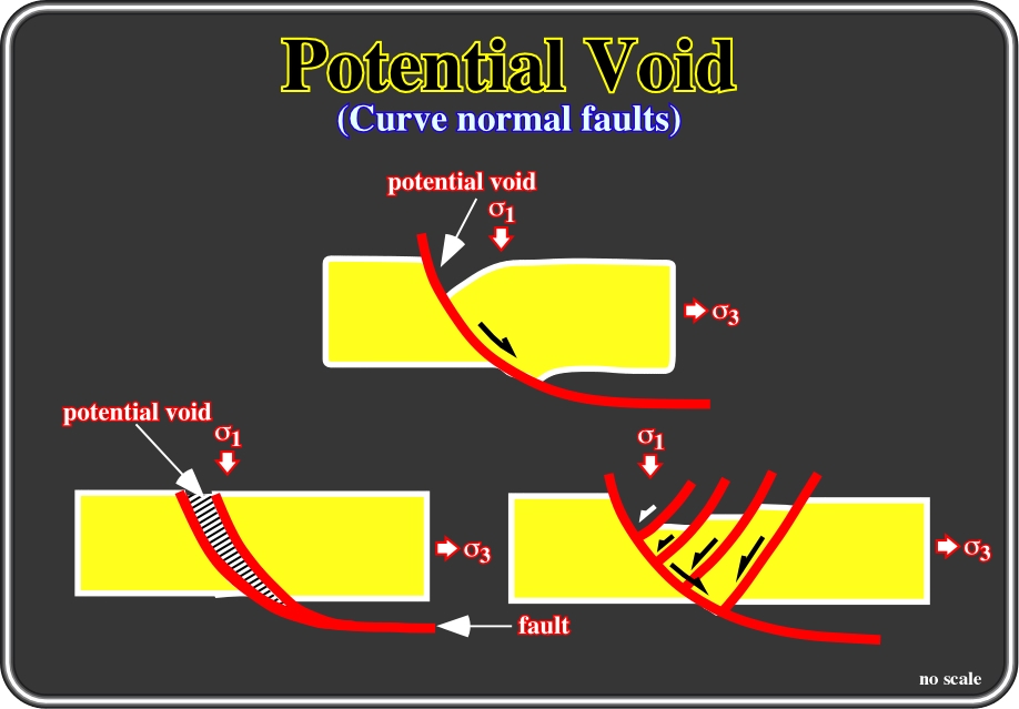
Fig. 104- The potential void, created by an extensional tectonic regime (
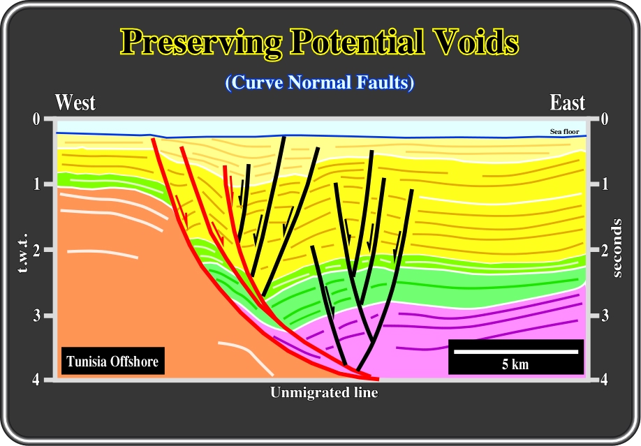
Fig. 105- The previous model of space and volume accommodation (fig. 104) is corroborated by this interpretation of a seismic line from offshore Tunisia, in which two major synthetic faults, looking eastward, materialize the extension created by an extensional tectonic regime. Antithetic and some second order synthetic faults lengthened the sediments to fill the potential void. Notice that a small rotation of the major hangingwalls contributed also to balance the potential void.
C.2.3- Extensional Uplift & Potential Void
An extensional uplift, induced by a salt diapir, or a volcanic plug, for instance, curves the sediments on the top of the intrusion creating a potential void. The lengthening of the sediments by normal faulting fills the space created, as illustrated in fig. 106. Generally, extensional uplifts induce local extensional tectonic regimes characterized by a biaxial ellipsoid of the effective stresses, in which
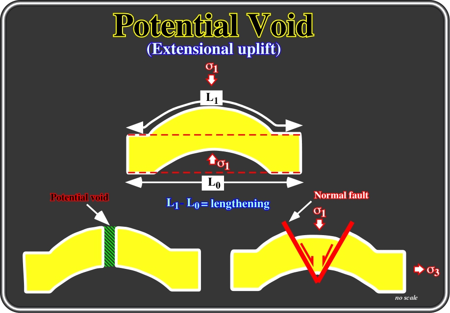
Fig. 106- This model is quite interesting, since, very often, geologists fail to differentiate anticlines and antiforms. An anticline is a fold, generally convex upward, whose core contains the oldest stratigraphic rocks. An antiform is a fold whose limbs close upward in strata for which the stratigraphic sequence is not known. All anticlines are antiforms but not all antiforms are anticlines. An antiform can be created by an extensional tectonic regime (
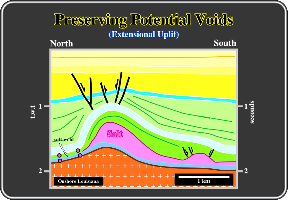
Fig. 107- This antiform structure is clearly associated with a local extensional tectonic regime (
C.2.4- Tectonic Tilting & Potential Void
As illustrated in fig. 108, a tectonic tilting creates also a potential void and so the sediments are lengthened by normal faults in order to fill the space created while preserving their volume.
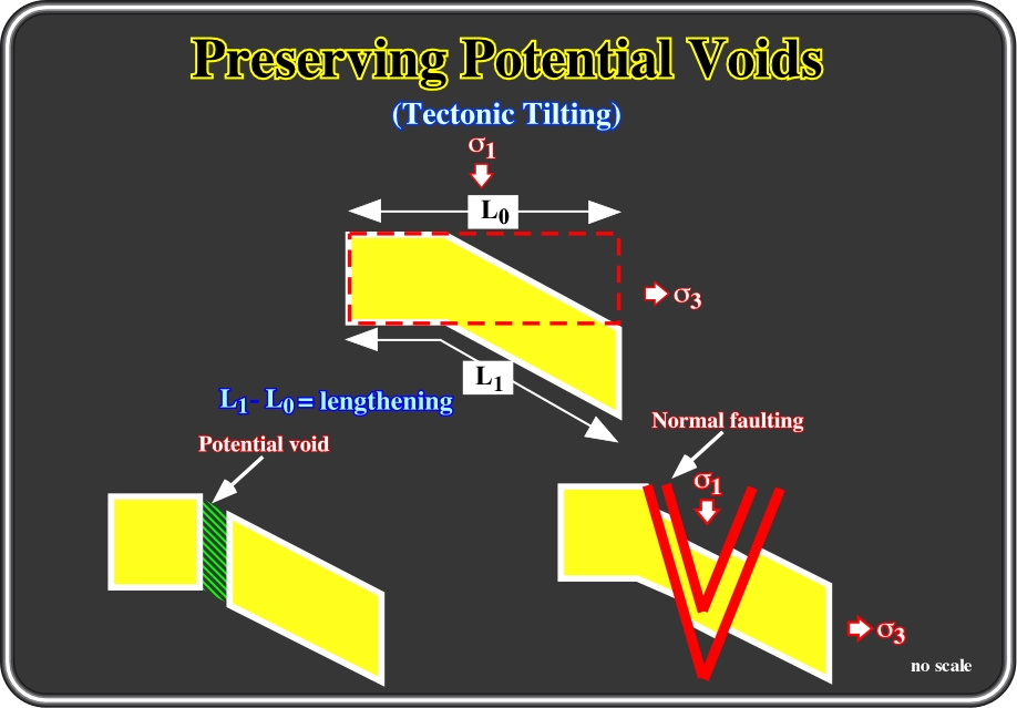
Fig. 108- Local or regional tilting generates extension of the sediments near the hinge. Theoretically, as illustrated, a potential void is created; and the sediments, to prevent such a void, are lengthened by normal faults generally with opposite vergence, as illustrated in figure 109.
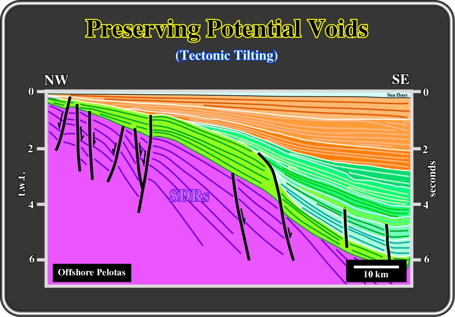
Fig. 109- This interpretation from a seismic line of the Pelotas offshore (Brazil) illustrates that even the subaerial lava flows (SDRs), deposited immediately after the breakup of the lithosphere, following a seaward regional tilting, were faulted and lengthened to fill the space created by the tilting.
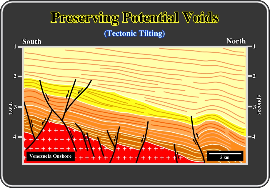
Fig. 110- Southward of Urica fault (reverse/strike slip fault on right of the line), i.e. near the Officina area (south Barinas basin), volume problems, created by flexural subsidence (foredeep basin), are solved by normal faults with opposite vergence. On the left of this seismic interpretation, such a normal faulting is quite evident. The large normal fault looking northward (on the left part of the interpretation) displaces a reactivated normal fault normal bordering a rift-type basin (dark brown). Notice that in this area, stacking of different types of basins can be recognized. From bottom to top: (i) a metamorphic foldbelt (in red), (ii) several rift-type basins (in dark brown), (iii) a non Atlantic-type continental divergent margin (in light brown, orange and yellow) and a foredeep basin (in beige). The limit between the divergent margin and the foredeep basin is marked by a sharp unconformity (foredeep basal unconformity).
press
![]()
Send E-mail to ccramez@compuserve.com or cramez@ufp.pt with questions or comments about this short-course.
Copyright © 2000 CCramez
Last modification:
Agosto 27, 2006