
Universidade Fernando Pessoa
Porto, Portugal
IX- Paleogeography patterns through Time
Before starting to interpret seismic data in geological terms, it is useful that interpreters know, at least, at the begriming of interpretation, the basic changes of earth and life through time. They must have some idea about the different paleogeographic hypotheses advanced, in order to know, a priori, what they must look for on seismic lines and to understand what and why they pick particular reflectors.
In seismic interpretation, “Theory precedes Observation”. The hypothetical-deductive approach proposed by K. Popper is, by far, the one allowing explorationists to progress, quickly, in the understanding of hydrocarbon problems. In such an approach, scientific progress is made by trial and errors. Without errors there is no progress, but as James Joyce1 said:
“People of genius make no mistakes. Their errors are volitional and are the portals to discovery”.
The summarized eclectic review of the major geological events through time proposed hereunder is based on paleogeographic maps and comments taken mainly from Stanley2, Bally3, PALEOMAP Resource Pool4 and Macdougall5.
Geologists have long attempted to determine how continents of modern world originated. They have managed to trace the histories of these continents only into Proterozoic time. The configurations and relative positions of the oldest Archean microcontinents will probably be never known. The difficulty of such reconstructions is that the depositional patterns and structural trends of rocks more than half billion years old are often obscured by erosion, metamorphism, or burial.
Nonetheless, geologists by reconstructing partial histories for most of the largest blocks of Proterozoic crust gained some knowledge about how they became part of the Phanerozoic world.

Fig. 36- The Greenville folded-belt can be interpreted as a megasuture created by gathering of Proterozoic continents.
The Late Proterozoic supercontinent (Proto-Pangea) was assembled by suturing along orogenic belts of Greenville age (plate 38). The relationships between the Greenville orogeny (1.2-1.0 Ga) and the Middle Proterozoic rifting in central Laurentia (Central and Eastern North America) remains a puzzle. The Greenville event entailed the collision of eastern Laurentia with another large craton (East Antarctica, South Africa, Congo, West Africa, North S. America) which apparently included a landmass that had later become a major component of the Gondwana. Forming another segment of the colliding landmass was Baltica.
At the beginning of Phanerozoic the Precambrian supercontinent broke-up into different fragments and, particularly, Laurentia and Baltica started to drift apart (plate 39). The possible arrangement of the continents at the Early Paleozoic, schematized on plate 40, implies an important reduction on the volume of the oceanic basins due to development of oceanic ridges mainly between Laurentia and Baltica in so far as the opening of Iapetus Sea.
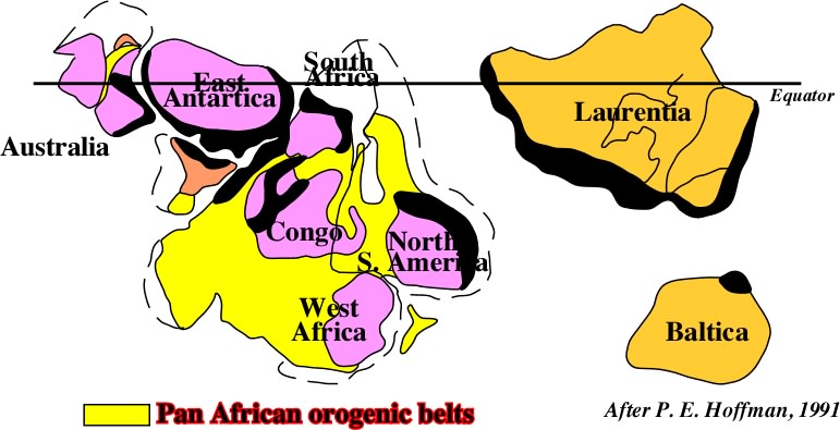
Fig. 37- The drifting of the continents individualized by the breakup of the Proto-Pangea, created new ocean in the Panthalassa, particularly the Iapetus and the Rheic.
As the amount of water is considered constant since the Earth's birth, the reduction of volume of the oceanic basins induced a global sea level rise. Important surface of the continents were flooded and covered by shallow seas.
The arrangement of the continents at the end Cambrian is illustrated on plate 40. By that time the Gondwana and smaller landmasses such as: Siberia, Kazakhstania, Laurentia, etc., occupied equatorial zones. Baltica, on South hemisphere, and China, on North hemisphere, occupied tropical zones. All continents were positioned at low latitudes. The sea level rose mainly due to rifting of the continents, and many of them were partially inundated by shallow seas. Two factors:
(i) low latitudes and (ii) eustatic sea level rise,
explain why Cambrian limestones significantly encroached onto the Precambrian cratons.
As the Cambrian Period progressed many parts of the Gondwana remained above sea level, partly as a result of regional uplift caused by orogenic activity between some of them. Nevertheless, the Cambrian flooding represented one of the largest and most persistent sea level rises of the entire Phanerozoic Eon.

Fig. 38- Following the breakup of Proto-Pangea supercontinent, the drifting of the individualized continents created a huge eustatic sea level rise induce development of oceanic mountains (oceanic ridges), which strongly reduced the volume reduction of the oceanic basin.
An interesting aspect of the Cambrian story bears on the Burgess shale. The rapid diversification of animals during this period was not restricted to those with the hard parts. If changed ocean water composition was important in the development of skeletons and shells, it was only part of the reason for amazing diversification of life.
The most famous occurrence of Cambrian fossils is the Burgess shale, in the Rocky Mountains of Southern British Columbian. From a single small quarry in these shale came tens of thousands of fossils exhibiting a stunning range of shapes and body forms. Their study has provided paleontologists with priceless information about the workings of biological evolution.
The fascinating tale of the discovery and study of the fossils in the Burgess shale is told with great skill in the book Wonderful life (Gould6). Gould posed the fascinating question:
What if the tape were rerun?
Regardless of differences in interpretation of the Cambrian fossil record, most experts in this field would probably agree that the result - today's animal world - would be different, quite possibly radically different. The Cambrian explosion resulted in an oceanic flora and fauna that was without precedent in earth's history. “But it was only a beginning” wrote Macdougall7:
“Very rapidly by standards of the vast tracts of time that had already passed by, new life forms arose. But also, older ones declined and sometimes quite suddenly became extinct. The precise causes of these rapid changes are not known in detail, but most of them were probably responses to external stimuli. If the world had been completely stable, with unchanging climate, uniform environments, a constant population density and no continental drift, many of these changes would probably never have occurred. At best they would have taken place much more slowly”
Rapid diversification in the Cambrian (and also at some later times), coupled with apparently random extinctions, left groups of survivors that made it more by chance than any kind of predestination. One of these trilobite “mass extinctions” marks the end of the Cambrian period.
Certainly factors such as adaptability and tolerance to a wide range of environmental conditions must have helped, but if the process were restarted it is unlikely that same groups would persist.
After its general rise during the Cambrian Period, two small sea level falls were recognized:
(i) one during Middle Cambrian and
(ii) one during the Upper Cambrian.
Sea level stood high during much of the Ordovician time, flooding broad cratonic areas. The widespread regressions of this period do not appear to have any major effect on marine life.

Fig. 40- The collision between Laurentia and England and South Ireland (closing of Rheic sea) creates the first large Paleozoic suture, i.e. the Taconian folded belt.
However, there is abundant evidence, that a cooling of climate contributed to major marine extinction. This marine extinction took place at the close of the Ordovician Period.
As late as Middle Ordovician time, the center of Baltica lay far south for equator (Fig 40). The Ordovician temperature gradient from equator to pole was nonetheless gentle enough to allow diverse marine fauna to occupy the shallow seas of Baltica.
During the latter half of Ordovician, Baltica moved toward the equator where England and South Ireland, each of which had either been attached to the North African margin of Gondwana or had lain nearby. It was this movement that brought Baltica close to the eastern margin of Laurentia when the first Paleozoic tectonic cycle of Appalachian region ended with orogeny (Taconian) and with deposition of flysh and clastic wedges.
However, it was not until Silurian-Devonian time, that the Iapetus Ocean closed and Baltica was united with Laurentia, England with Scotland, and North Ireland with the southern part (Acadian-Caledonian orogeny). The mass extinction at the close of Ordovician time was one of the most severe ever strike life in the oceans. It devastated particularly the tropical reef community.
In fact, while Baltica moved toward the equator, Gondwana moved poleward. Thus, while Baltica became warmer, southern parts of Gondwana became much cooler. Gondwana lay squarely on the equator late in Cambrian time, but by mid-Ordovician time only its northern margin was equatorial.
Several millions years before the end of Ordovician Period glaciers grew in and around the south polar regions of Gondwana, and as the period came to a close, the glacial episode reach a climax that was accompanied by a mass extinction in marine realm.
In general, Silurian and Devonian were periods where the sea level stood high in relation to the surfaces of major cratons (fig. 41).

Fig. 41- In Middle Silurian, the Iapetus Sea (ocean between Laurentia and Baltica) still is quite large. Partial melting of the polar glaciers on the new continent (Laurentia + England + N. Ireland) created a sea level rise. The coastal deposits were displaced landward creating the Middle Silurian transgression.
Early in Silurian time, sea level rose from its low position at the end of the Ordovician Period. This rise is thought to have resulted from the melting or partial melting of the extensive polar glaciers that had formed late in Ordovician time.
At the beginning of Devonian the sea level fell slightly, and then rose until the Late Devonian, before it fell again due to the onset of Gondwana's glaciation. The widespread occurrence of organic reefs, carbonates and evaporites strongly suggests that Middle Paleozoic climates were relatively warm and locally dry. In fact, large volumes of evaporites deposits ac- cumulate in Middle Paleozoic.
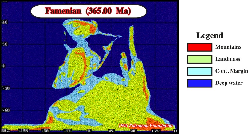
Fig. 42 – In Early Devonian, the Iapetus deep ocean did not exist anymore, only a shallow sea is present. The collision between the Laurentia and Baltica is eminent. The Iapetus is going to disappear. A new continent (Old Red Sandstones) will be created.
Fig 41 displays the positions of continental areas during Middle Silurian time and plate 42 displays the continental areas during Late Early Devonian time, about 65 My later. An important new geographic feature to ap- pear during Devonian time was the Old Red Sandstone continent (ORS). This continent of high relief formed when Laurentia and Baltica were welded together as the Iapetus Ocean disappeared. This collision began in the north during the Silurian Period and progressed southward, ending late in Devonian time (Acadian-Caledonian Orogeny). Following the cooling of polar regions, a discrete marine province (Malvinokaffric Province), populated by fauna living in cool water, formed along the margins of southern Gondwana.
Though stromatoporoids, tabulates, and rugose corals formed reefs throughout most of the shallow water areas in the Devonian world, it is not surprising that they were not found in the Malvinokaffric province.
One of the most devastating mass extinctions of marine life in Phanerozoic time took place near the end of the Devonian Period, where geologists usually consider two stages: (i) Frasnian and (ii) Famennian stages. The great extinctions occurred late in Frasnian and early in Famennian time. The glacial episode that began in Late Ordovician time, when Gondwana migrated over the South Pole, appears to have ended during the Silurian Period. Because no glacial deposits of Early Devonian age are known in Gondwana, it has been suggested that Gondwana migrated away from the South Pole in Late Silurian time, so that its southern region became less frigid. In any event, near the end of the Devonian Period, glacial deposits were laid down again in Gondwana. The location was northern South America, then near the South Pole, which lay in eastern Africa according to paleomagnetic data. Thus appears that an episode of polar cooling and glaciation began in Late Devonian time, about the time the mass extinction struck marine life in the tropics. This association strengthens the idea that climatic cooling caused the extinction. This glacial episode is important to notice because it explain why large amplitude downward shifts of coastal onlap can commonly be observed during the Frasnian.
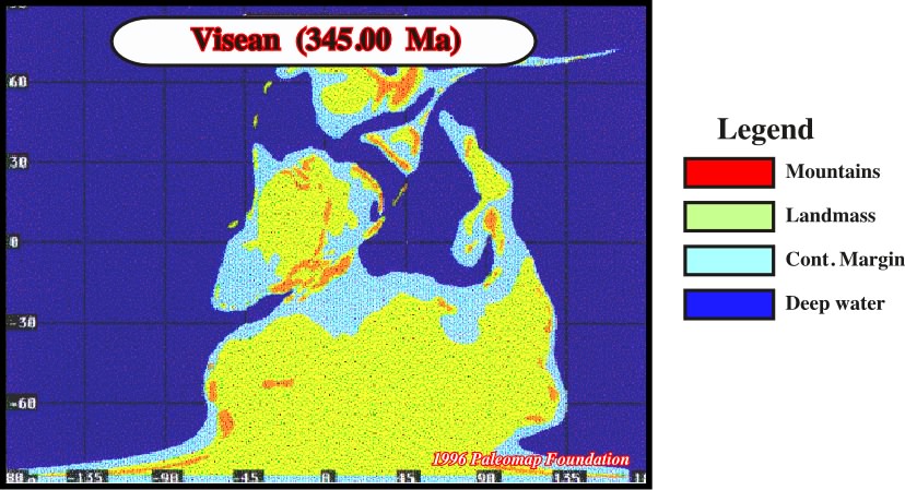
Fig. 42- In Carboniferous, the birth of a new supercontinent became eminent. The gathering of the continent became more evident as well as the sea level fall.
During Late Paleozoic time the major continents moved closer and closer together until by early Mesozoic time they seem to have fused together (Pangea). The agglutination of the continents produced an increase of the volume of oceanic basins which had contributed to a global sea level fall.
Even early in the Carboniferous Period, the continents were rather tightly clustered. The Old Red Sandstone continent persisted from Devonian time north of the Téthys sea. At low latitudes, coal deposits were formed along the eastern portions of the continents, and limestones and evaporites accumulated in many areas especially in Midcontinent Province to the west of the Old Red Sandstones continent. Enormous glaciers spread over Gondwana near the South Pole.
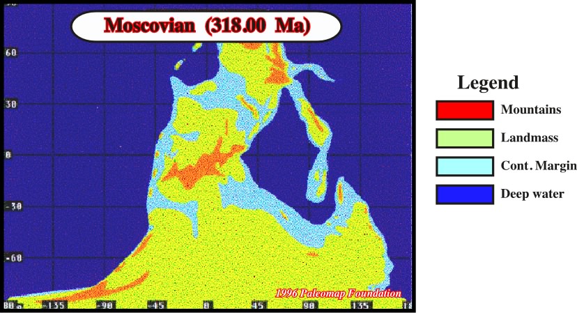
Fig. 43- By the end of Carboniferous, the Pangea supercontinent, the Téthys Sea and the Panthallassa were the major elements composing the upper level of the Earth.
In the Late Carboniferous (plate 45) the Téthys sea was closed in association with the Hercynian mountains building. Coal deposits formed over a larger total area at this time than at any other period in Earth's history. In Gondwana, continental glaciers spread to remarkably low latitudes and were separated from tropical coal swamps (formed by Euramerian flora) by steep temperature gradients. The Gondwana and Siberian floras flourished under cooler conditions. As this period progressed, the sector of Gondwana that laid over the South Pole became covered by a large continental glacier, franging the ocean in South Arabia, that persisted into the Permian. Meanwhile, hot conditions prevailed in equatorial regions. The late Paleozoic was a time of vast biotic change and time of changing and extreme climatic conditions. The sea level, which had declined near the end of the Devonian Period rose again during Early Carboniferous time, so that warm shallow seas spread across broad continental surfaces at low latitudes.
As a result limestones accumulated over larger areas, often with crinoids debris as their most important component. Early in Carboniferous time, limestones accumulated in many areas of Gondwana, but near South Pole, temperatures were strikingly cooler. Tillites reveal that throughout all or nearby all of Carboniferous time, large areas of Gondwana were blanketed by ice sheets. Warm, moist conditions prevailed in some continental areas near the equator. The transition from Early to Late Carboniferous time was marked by two important events:
(i) Global decline in sea level and (ii) Heavy extinction of marine life.
In many parts of the world, the drop in sea level is evidenced by a disconformity (hiatus) in shallow marine deposits. Presumably, the sea level fall during this crisis was caused because glaciers expanded in Gondwana locking water up on the land. Perhaps the Mid-Carboniferous extinction resulted from cooling of the seas that was associated with expansion of glaciers.
During the middle portion of Carboniferous time, the northward movement of Gondwana caused this continent to collide with the ORS continent. The mountains that formed in Southern Europe are known collectively as Hercynides and the orogeny as a whole is known as the Hercynian or Variscan. Hercynian mountains also formed in Northwestern Africa, the Mauritanides. In North America, the Hercynian orogeny known as Alleghenian orogeny, in effect, continued when the Caledonian orogeny left off, extending the Appalachian mountain chain southwestward and forming the adjacent Ouachita Belt.
There is a compelling evidence that the floras of Gondwana and Siberia grew under cold conditions. In contrast, the Euramerian fossil trees which grew near the Carboniferous equator were of the tropical type. This change foreshadowed greater climatic changes during Permian time.
As a result of complex topographic conditions and steep climate gradients, the floras of Permian time were more provincial than those of any other Phanerozoic period. The Permian floras remained distinct even though they were not separated by vast oceans. In Permian time, the suturing of Siberia to eastern Europe along the Ural mountains resulted in the nearly complete assembly of Pangea as shown in the plate here above.
Southeast Asia remained as the only separated landmass of large size, and it would be attached during Mesozoic Era. Contributing to climate contrasts of the late Paleozoic globe were several mountains chains including those of the Hercynian, which formed during the suturing of Gondwana to the ORS continent. Furthermore, polar regions remained quite cold and equatorial regions quite hot. As a result of these contrasts, the Late Permian flora of low latitudes remained distinct from Glossopteris flora of the south and from that of Siberia, a continent, although now attached to Europe, remained near the North Pole. Southeast Asia was still a separate continent, and by now its flora became unique.
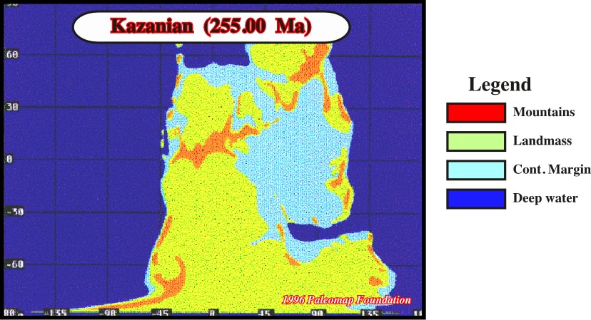
Fig. 44- The Pangea is completed formed. It is composed by two major continents. In the south the Gondwana and, in the north the Laurentia. SE Asia remained a individualized landmass. It marks the eastern limit of the Téthys Sea.
The Euroamerian flora had also now broken down into more local floras separated by barriers. The highly arid conditions of Permian time resulted in the deposition of great thickness of evaporites in the Southwestern United States and in Northern Europe.
It is difficult to determine the pattern of the marine extinction in time and space because marine stratigraphic sections that spare the Permo-Triassic boundary without interruption are rare. Discontinuities represent the crucial interval in nearly all continental areas, because global sea level fell dramatically in Late Permian time, causing continental surface to experience erosion rather than deposition.
The huge supercontinent that included nearly all of Earth's landmasses was moving northward in Late Permian time, stretching virtually from pole to pole. Perhaps its encroachment on the north pole caused large glaciers to form here for the first time in the Phanerozoic Era.
This may also have been the first time that both of Earth's polar regions were icy at the same time. In addition, sea level dropped substantially, in Late Permian time, eliminating the warm shallow seas that had flooded the continents. The cause of the crisis that ended the Paleozoic Era is still a subject to debate.
About the time the Mesozoic Era began, all of the major landmasses of the world became united as the Supercontinent Pangea.
Near the end of the Triassic time, Pangea started to break apart, but continental movement was so slow that even by the end of Jurassic time the newly forming continental fragments were hardly separated. Throughout the early Mesozoic Era, Earth's continental crust was concentrated on one side of the globe.
Sea level rose slightly during Early Triassic time. As in Late Permian time, however, the bulk of the continental crust during the Triassic stood above sea level, forming one vast continent.
At the start of the Triassic time, the Téthys, sometimes called the Tethyan Seaway, was an embayment of the deep sea projecting into the portion of equatorial Pangea that today constitutes the Mediterranean Sea.
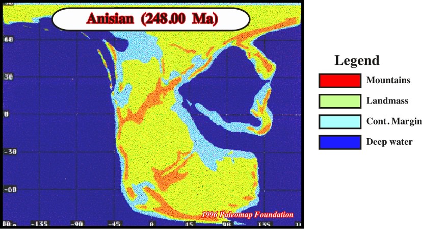
Fig. 45- In Triassic time, the Pangea lithosphere started to be lengthened. Rift-type basins took place. Only along the margins of the Téthys Sea, Triassic marine Triassic sediments were deposited.
Later in Triassic and Jurassic time, rifting extended the Téthys between Eurasia and Africa and all the way westward between North and South America to Pacific. Although the dominant land plants of the Triassic Period differed from those of the Permian, the distributional pattern of flora on Pangea remained much the same.
A Gondwana flora existed in the South and Siberia flora in the North. The Euroamerian flora grew under warmer dry conditions at low latitudes. In fact, unusual deposition of evaporites attests to the presence of arid climates far from the equator.
This conditions may have resulted in part from the sheer size of Pangea, which was so large that many of its regions lay far from the low standing oceans. The most spectacular geographic dev elopement of the Mesozoic Era was the fragmentation of Pangea, an event that began in Tethyan region.
As the Triassic period progressed the Tethyan Seaway spread farther and farther inland and eventually the craton began to rift apart. The Tethys Sea subsequently became a deep, narrow arm of the ocean separating what is now southern Europe from Africa.
During the Jurassic Period, this rifting propagated westward, ultimately separating North and South pole from the South Atlantic until Cretaceous Period. In fact, all former Gondwana continents remained attached to one another until Cretaceous time.
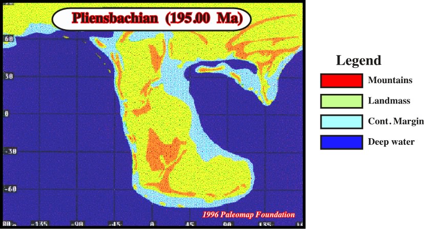
Fig. 46 -In Jurassic time, North America started to be individualized from Africa, while the Gondwana was strongly rifted, i.e. lengthening with creation of rift-type basin, where organic rich Acutrim shales (potential source rocks) were deposited.
North America began to break away from Africa in mid-Jurassic time. Interestingly, this rifting generally followed the old Phrygian suture. Rifting occurred on some arms of series of triple junctions joined, tearing Pangea in two. The rifting that formed the Atlantic had another important consequences:
- When continental fragmentation begins in an arid region near the ocean, evaporites deposits often form in that region.- Pangea extension produced normal faults between Africa and northern continents
“zones bounded by such faults sank, and water from the Téthys to the east periodically spilled into the trough and evaporated”
- Evaporites that were precipitated in these troughs are now located on opposite sides of the Atlantic, both in Morocco and offshore Nova Scotia and Newfoundland.
- During Middle and Late Jurassic time one arm of rifting formed westward between North and South America, giving rise to the Gulf of Mexico-Senegal.
- Intermittent influxes of seawater into this rift (apparently from Pacific ocean) caused great thickness of evaporites (Loan salt) lie between the Gulf of Mexico and in subsurface of Texas and Senegal.
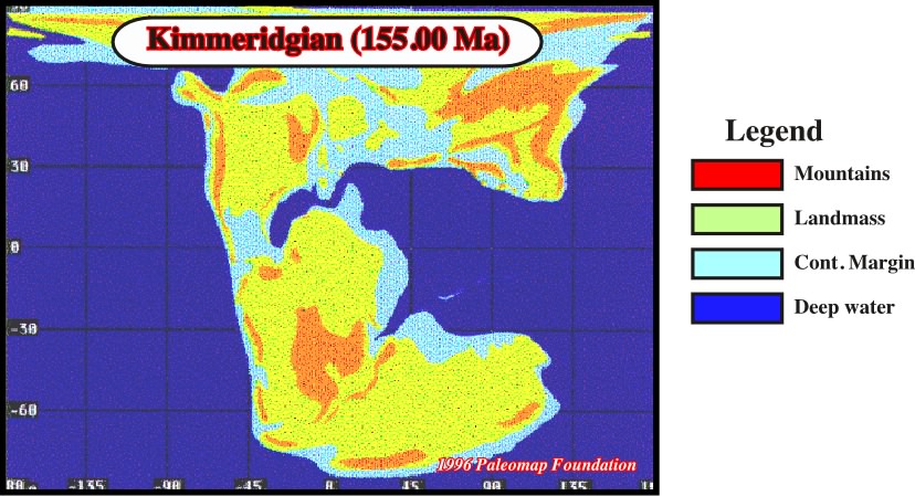
Fig. 47- In Middle Jurassic, a large transgression took place in northern continents. In Gondwana, the lithosphere reached the minimum thickness, beyond which extension is unlikely, i.e. the breakup between South America and Africa will happen soon.
Throughout most of Cretaceous time the seas stood much higher than they do today. Widespread shallow marine deposits on continental surfaces (together with no marine and deep sea sediments) reveal that in many ways Cretaceous Period was an interval of transition.
It was during the Cretaceous that continents moved toward their modern configuration. At the start of the Period the continents were tightly clustered, and Gondwana was prominent in the South. By the end of Cretaceous time, however, the Atlantic ocean have widened and Gondwana had fragmented into most of its daughter continents. In the course of the Cretaceous there was a global rise of sea level, with only minor interruptions.
As a result, sea level stood perhaps as high throughout most of the Late Cretaceous, as at any other time in Phanerozoic history of the Earth, and continents were extensively blanketed by marine deposits. As for example Late Cretaceous series resting on Paleozoic in the Sahara.
Fig. 48- At Lower Cretaceous, South America and Africa are almost totally individualized and Gulf of Mexico of became a typical Mediterranean basin, i.e. not yet a divergent Atlantic-type margin.
- Although Pangea had begun to break apart early in the Mesozoic Era, the smaller continents that had formed from the supercontinent remained tightly clustered at the begriming of the Cretaceous Period.
- The continued fragmentation of the Pangea and the dispersion of its daughter continents were among the most important development in global geography during Cretaceous time.
- Especially dramatic was the break-up of the Gondwana into two stages.
- At the start of the Cretaceous, Gondwana, still intact, was barely attached to the northern continent.
- By the end of the period, South America, Africa, and India peninsula had all become discrete entities.
- At that time, continents that represent fragments of Gondwana, only Antarctica and Australia remained attached to each other.
- The life of the Cretaceous Period, both in the sea on the land, was a curious mixture of modern and archaic forms.
Because the Cretaceous System has undergone less metamorphism and erosion than older geologic structures, it is represented on modern continents by an extensive record of shallow-marine and non marine sediments and fossils.
Fig. 49- By the end of the Cretaceous, the Earth paleogeogaphy starts to seem similar to the paleogeography of the present day. India and Australia started moving northward.
In addition, Cretaceous sediments and fossils were widespread in deep sea, in contrast to sparse deep sea records for Triassic and Jurassic periods. This difference reflects the fact that movements of plates across Earth's surface are rapid enough so that a large percentage of deep sea sediments older than Cretaceous have been swallowed up along subduction zones. The relative abundance of Cretaceous sediments in ocean basins and on the continents helps us to interpret paleogeographic patterns and global events of the period.
The end of the Cretaceous Period marked a major transition in the Earth's history. Never again were calcareous nannonplanktonics so abundant. They formed massive chalk deposits scarcely any belemnoids survived, and amonoids, rudists, and marin reptiles disappeared from the sea. The most profound geographic change during Paleogene (Paleocene, Eocene and Oligocene) time was the refrigeration of the Earth's polar regions, which resulted in chilling of the deep sea and ultimately in widespread glaciation.
The only major event of continental rifting that took place exclusively during Cenozoic Era was the separation of Australia from Antarctica, which occurred close to the end of the Eocene Epoch. With the inception of this rifting early in Eocene time, Australia began to move northward, and the resulting alteration of wind and water circulation near the South Pole had consequently extended over much of the planet.
Even before its separation from Australia, Antarctica had been centered over the South Pole. But it had remained warm because its shores were bathered in relatively warm water from lower latitudes. When Australia broke away and drifted northward, a cold current formed between the two continents, deflecting the warm current that flew toward Antarctica from Australia. This was the first change to cause cooling in Antarctica.
Fig. 50- At Eocene time, India almost collided with Eurasia. Antarctica and New Guinea are moving northward. Globally, the Earth paleogeography is quit similar to that of Present time.
Paleogene mountain building events in western North America preshawoed Neogene uplifts of such ranges as Sierra Nevada and Rocky Mountains. In southern Europe the Paleogene elevation of the Alps was of comparable significance. Major geologic and geographic changes also took place during Paleocene Period within 30º latitude of the North Pole. Many of the changes can be read from the age of various segments of the deep sea:
(i)- The Arctic deep sea basin existed during Cretaceous Period, but until nearly the end of Cretaceous time it remained separated from Atlantic, except by way of shallow sea, because North America, Greenland, and Eurasia were still united as a single landmass.
(ii)- The Mid-Atlantic rift formed northward along two forks, splitting Greenland from North America on the west and from Europe on the East.
(iii)- Finally, in mid-Paleogene time, the pattern of the plate movement simplified as the western arm of the rifting ceased to be active, ending the relative movement of the Greenland away from North America.
Mountain-building activity in the Cordilleran region of North America continued into the Paleogene Period, but with a number of changes which summarized the orogenic history of the eastern Cordilleran region. In the latest Cretaceous time, however a different stage of tectonic activity was initiated in the western America. This activity persisted throughout the Paleocene and well into the Eocene time - the Laramide Orogeny.
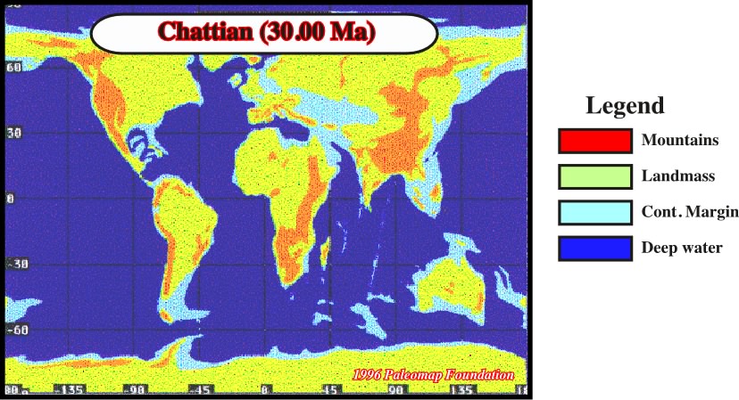
Fig. 51- At Oligocene time, the old Téthys was almost completely closed, only small vestiges remained: Mediterranean Sea, Black Sea, Caspian sea and Aral Sea.
During the Neogene, the modern world took shape that is the ecosystem acquired. Its present configuration and important topographic features assumed the forms we are familiar with today. No mass extinction marked the close of the Paleogene and the start of the Neogene. During the scant 24 million years of Neogene, however, life and Earth's physical feature have changed significantly:
(i) The Rocky Mountains and the less rugged Appalachian took shape during Neogene time, as did the imposing Himalayas.
(ii) The Mediterranean Sea first dried-up and than rapidly formed again.
(iii) The most widespread physical change on Earth, however, was climatic. Glaciers expanded across large areas of North America and Eurasia late in Neogene. This glacial interval is commonly thought of as corresponding to the Pleistocene Epoch, it actually began late in Pliocene Epoch.
(iv) The collision of the African plate and southern India with Eurasia during Cenozoic Era destroyed what remained of the Tethyan Seaway.
(v) Today only vestiges of the Seaway remain in the form of the isolated Mediterranean, Black, Caspian, and Aral Sea.
Further East, the Tethyan Seaway was interrupted during Miocene time by the suture of the India Peninsula to the Eurasian plate, where molasse that shed southward from the newly forming Himalayas produced a lengthy and relatively complete fossil.
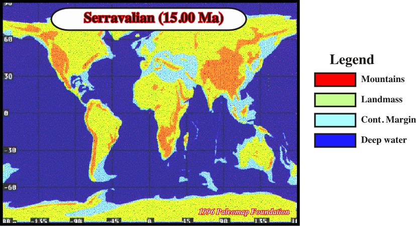
Fig. 52- Roughly, In Middle Miocene the paleogeography was the same than today. The onset of Siwalik deposition as well as the uplift of Rocky Mountains province the most important geological events of this period.
The famous Siwalik beds of Pakistan and India, for example, provide a nearly continuous record for the interval from 11 to 1 million years ago. The Swanlike beds document the composition of the rich faunas that occupied the spreading seaways of Late Miocene and Pleistocene age.
One of the most important Miocene events, the American West Cordillera region, was broad regional uplift that affected the Basin and Range Province, the Colorado Plateau, and the Rocky Mountains. A large part of the Grand Canyon, for example, was incised during the rapid elevation of the Colorado Plateau between about 10 and 8 My. Uplift in the Rockiest began slightly earlier, in Early Miocene time, and terrain that now forms the southern Rockiest has since rose between 1.5 and 3.0 km. Faulting and deformation was strong in California during Pliocene and Pleistocene epoch. Since the beginning of the Pliocene Epoch (about 5 Ma) the sliver of Coastal California that included Los Angeles has moved northward in the order of 100 km.
Although the Caribbean is now an embalmment of Atlantic Ocean, it was once connected to the Pacific. During Cretaceous Period, the floor of the Caribbean, which consists of volcanic rocks, was a small segment of the Pacific plate that was pushing toward the Atlantic. But during the Cenozoic Era, the Caribbean sea floor has lain along the north Coast of South America while the Atlantic plate has been subducted beneath it. The Caribbean plate became a discrete entity late in Cenozoic time when a new subduction zone came to connect the subduction zone bordering North America with the one bordering South America.
The African landmass remained unsually stable after hundreds of million of years, in part because mot of its are lay well within Gondwana for long time. Currently, however the strength of the African Craton is being tested by continental rifting, and it is not certain whether this great continent will survive or be will torn asunder.
_______________________________________
Notes (Paleogeography patterns through Time), (see Bibliography) :
1 - Quoted in Berry (1993), pp. 60.
2 - see Stanley (1992).
3 - seeBally, (1985).
4 - see Paleomap Ressource Pool, (1996).
5 - see Macdougall, (1996).
6 - see Gould, (1989).
to continue press
next
![]()
Send E-mails to ccramez@compuserve.com or cramez@ufp.pt with questions or comments about these notes.
Copyright © 2001 CCramez
Last modification:
Março 19, 2006