
Continental Divergent Margins
The continental divergent margins are associated to the oceanic expansion process caused by the mid-oceanic ridges. In fact, the mid-ocean ridges have a central fissure, called rift, along which volcanic material, coming from the sub-lithospheric mantle, is emitted, more or less, continuously forming new volcanoes and portions of oceanic lithosphere. In this way the younger rocks are in the center of the dorsal and near the rift. The age of the ocean floor increases as we move away from the oceanic rift. Over time (scale of millions of years), this oceanic spreading causes the ocean to become wider, so that the continents on both sides of the ocean move away from each other. The permanent renewal of the ocean floor by this continuous flow of magma makes the oceanic crust, generally, younger than the continental crust, at least in the nearer parts of the ridges.
Morphologically speaking, a divergent margin is composed by different units. By moving away from the expansion center we can identify successively:
(i) Mid-Oceanic Ridge (last rift-valley) ;
(ii) Ocean Floor ;
(iii) Sedimentary Wedge or Sedimentary Prism and
(iv) Continent.
The mid-oceanic ridge represents the summit part of the oceanic mountains. Its topography may be two or three thousand meters higher than that of the adjacent abyssal plain. The ocean floor represents the spreading zone of the oceanic crust ("rolling carpet" of C. Allegre, 1983). It corresponds to the whole abyssal plain, which water-depth increases toward the continental rise. The sedimentary wedge represents the continental accretion and it is formed by terrigeneous sediments deposited during different tectono-sedimentary episodes:
a) Rifting, during which the rift-type basins are formed and filled-up ;
b) Breakup of the lithosphere, which individualizes two new lithospheric plates and trigger off the margins deposition ;
c) Drifting during which the margin sediments are deposited.Some geoscientists consider in the margin development three main phases : (1) A sub-aerial phase volcanic phase with the characteristic lava-flows (SDRs) ; (2) A proto-oceanic phase, characterized by a shallow water or lacustrine deposition and (3) An oceanic phase in which marine deposition is paramount.
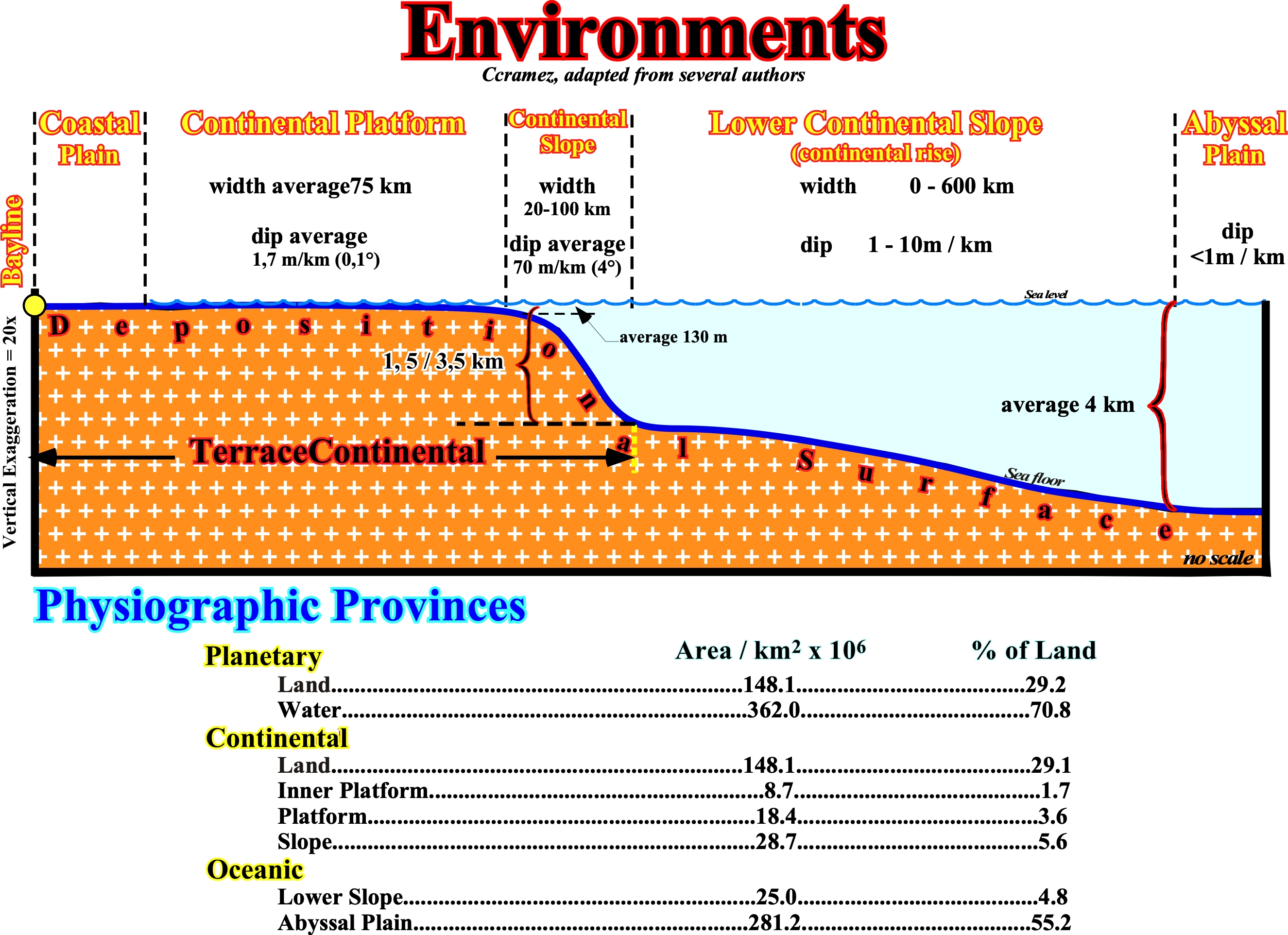
As illustrated on this sketch, along a depositional surface (chronostratigraphic surface), from the continent to the sea, there are different sedimentary environments:
(i) Coastal plain ;
(ii) Continental platform ;
(iii) Continental slope ;
(iv) Lower Continental slope and
(v) Abyssal plain.
The coastal plain (i) is a depositional surface upstream of the shoreline whose altitude is near the sea level. In sequential stratigraphy, the position of the inner boundary (upstream) of the coastal plain, which corresponds to the bayline, limits the coastal plain from the alluvial plain (not represented on this sketch). The outer limit of the coastal plain is, practically, the shoreline, which allows to define many different sedimentary contexts. For the followers of sequential stratigraphy, the coastal plain is formed by processes of progradation of the sea floor rather than by exhumation. The sediments that accumulate in the coastal plain, during the progradation of the shoreline, are part of what is called "the coastal wedge or coastal prism" (Posamentier & Vail), which includes fluvial and shallow-water deposits. The coastal prism is wedge-shaped and extends continentward by onlapping on the preexisting topography till the bayline. In general, when the geological conditions are of highstand (sea level above the basin edge), the outer limit of the coastal plain is very far from the basin edge (which in such conditions coincides with the continental edge): the basin has a shelf.
The continental platform, shelf or platform (ii) is the part of the continental margin extending seaward as a sloping surface, from the shoreline (or prodelta base) to the basin edge (beginning of the continental slope). The average depth of the continental platform, i.e., of the shelf is, roughly, 130 meters. When a geoscientist says platform, in general, he is referring the continental shelf (slightly sloping surface of the sea floor, limited between a water slide from 0 to 200 m), which is an oceanographic term. In geology, things are a little more complicated. To avoid misunderstandings, it is always important to know if the term platform is being applied to a sedimentary context where the clastics are predominant or to a carbonate context. In normal geological conditions, the water-depth of a limestone platform can not exceed the depth of the photic zone, otherwise there can be no carbonate formation, i.e., no photosynthesis.
The continental slope or borderland (iii) is the zone of continental margin dipping seaward, located between the platform (shelf) and the continental rise. The continental slope has a, relatively, strong slope between 3-6° and is, mostly, composed by deep-water sedimentary rocks, usually, shaly rocks. The lower continental slope (iv) or continental rise, considered by certain geoscientists as part of the abyssal plain, corresponds to the slightly bombed area at the foot of the continental slope upstream of the abyssal plain. The continental rise is formed by sediments that descend with variable speeds along the continental slope.
The abyssal plain or deep sea rise (v) is the region of the ocean floor (sea-floor) at the base of the continental slope with a declivity less than 1:1000 (downward inclination of the hypotenuses of a triangle, in which one of the cathetus is 1000 time longer that the other). An abyssal plain is, generally, covered with turbidite and pelagic deposits which, partially, mask the original topography.
![]()
![]()
Send E-mails to carlos.cramez@bluewin.ch with comments and suggestions to improve this atlas.
Copyright © 2001 CCramez
Last update:
2022
![]()