Parameter: Reservoir Rock
I- Introduction
In Type 1 or Type 2 deep offshores, the profitability of a hydrocarbon discovery is, mainly, a function of the productivity of the wells. A petroleum accumulation in which production wells bring out less than 5,000 barrels per day, will be, under current conditions (price per barrel around 35 USA dollars), non-economical. Potential reservoir rocks, which are more likely to give economic accumulations are turbidite reservoirs (sandstones or carbonates) deposited in recent sedimentary intervals, i.e., Upper Tertiary, see Holocene (see next two autotraces).
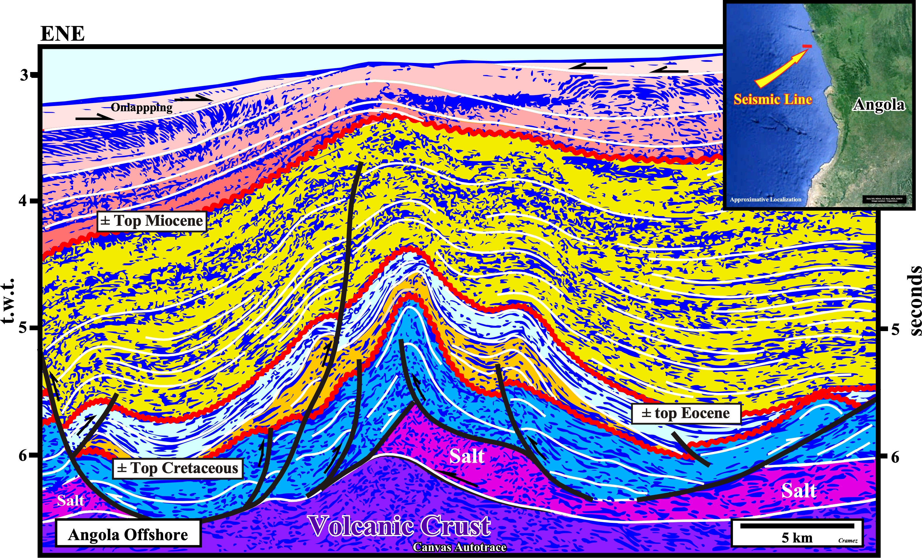
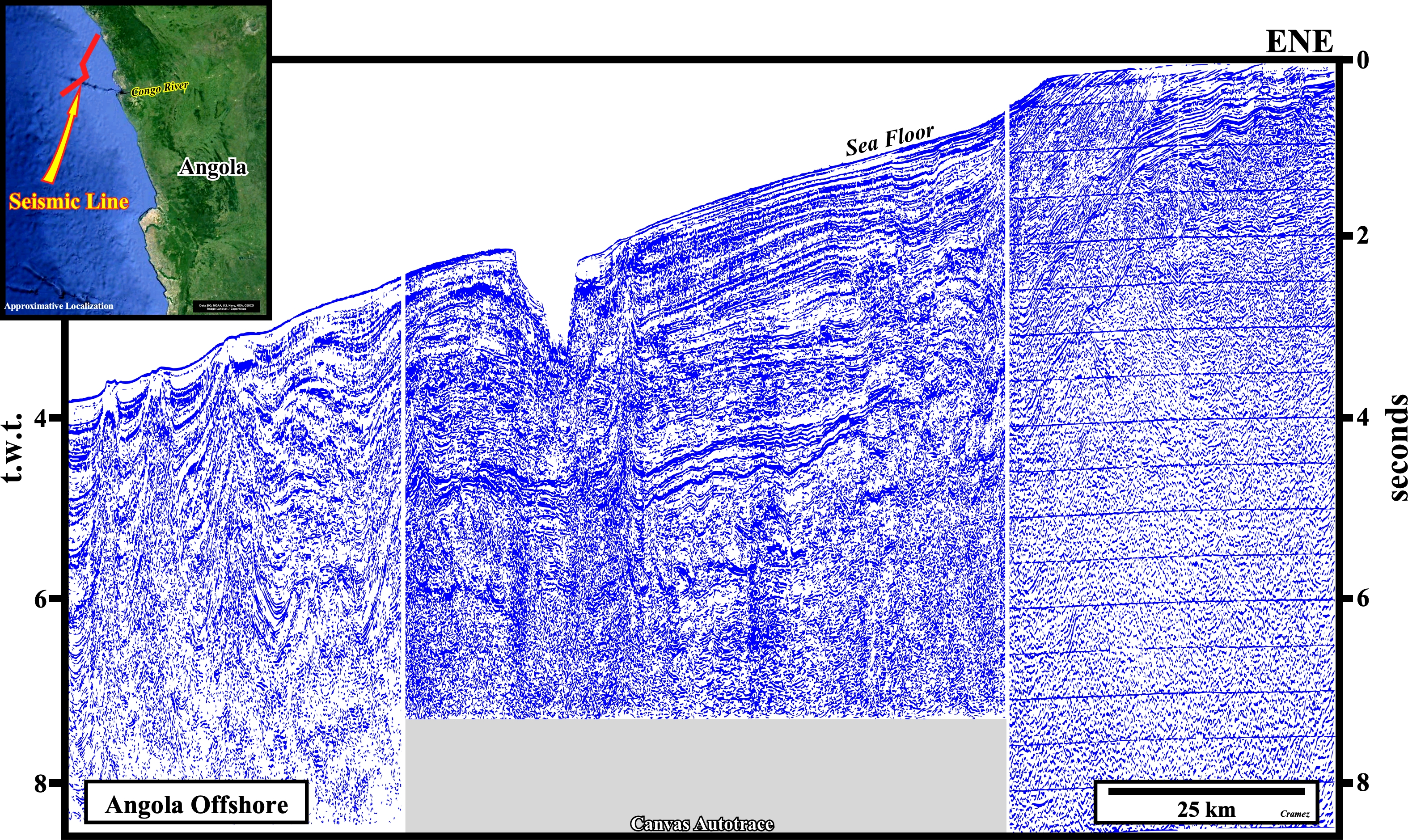
On this Canvas autotrace of a seismic line of the northern Angola offshore (South Congo offshore), the potential Cretaceous reservoir rocks (carbonates and / or carbonate sandstones) are unlikely to have the petrophysical characteristics necessary to give a productivity per well capable of making, in stand alone, the encountered hydrocarbon accumulations economical. The age, burial, migration time and duration of the geological periods of non-deposit are too important for a low diagenesis of these potential reservoir rocks. Notice that there two compressional tectonic regimes (sedimentary shortenings). The older shorts the cover sediments (salt + overburden) as a counterpart of the lengthening (extension) of the sediments in the upper continental slope and continental platform. The younger, probably, induced by an indirect action of the topography of the oceanic ridges (confining pressure) creates a large wavelength folding well recognized in the upper level and underlined by onlapping of the upper most sedimentary interval.
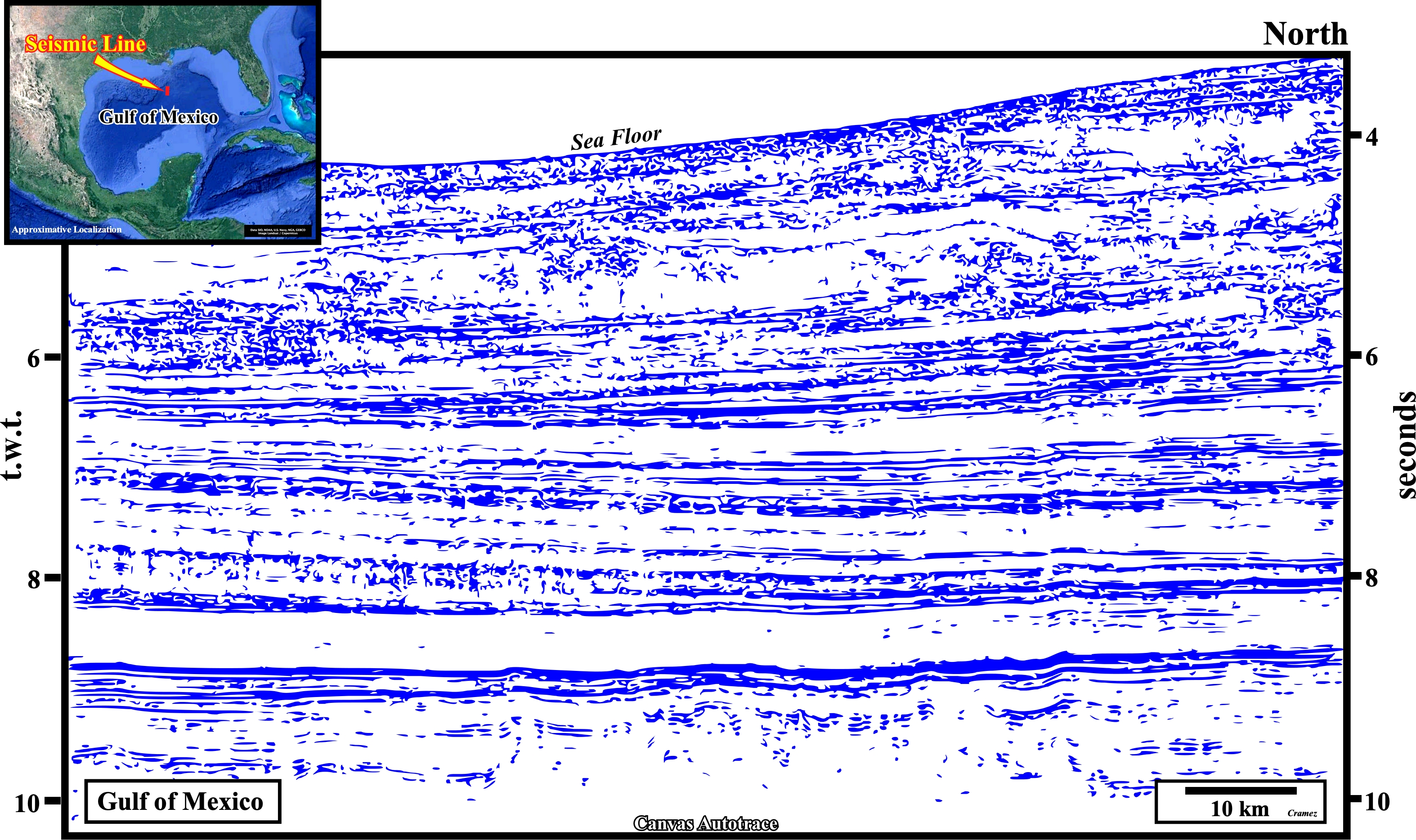
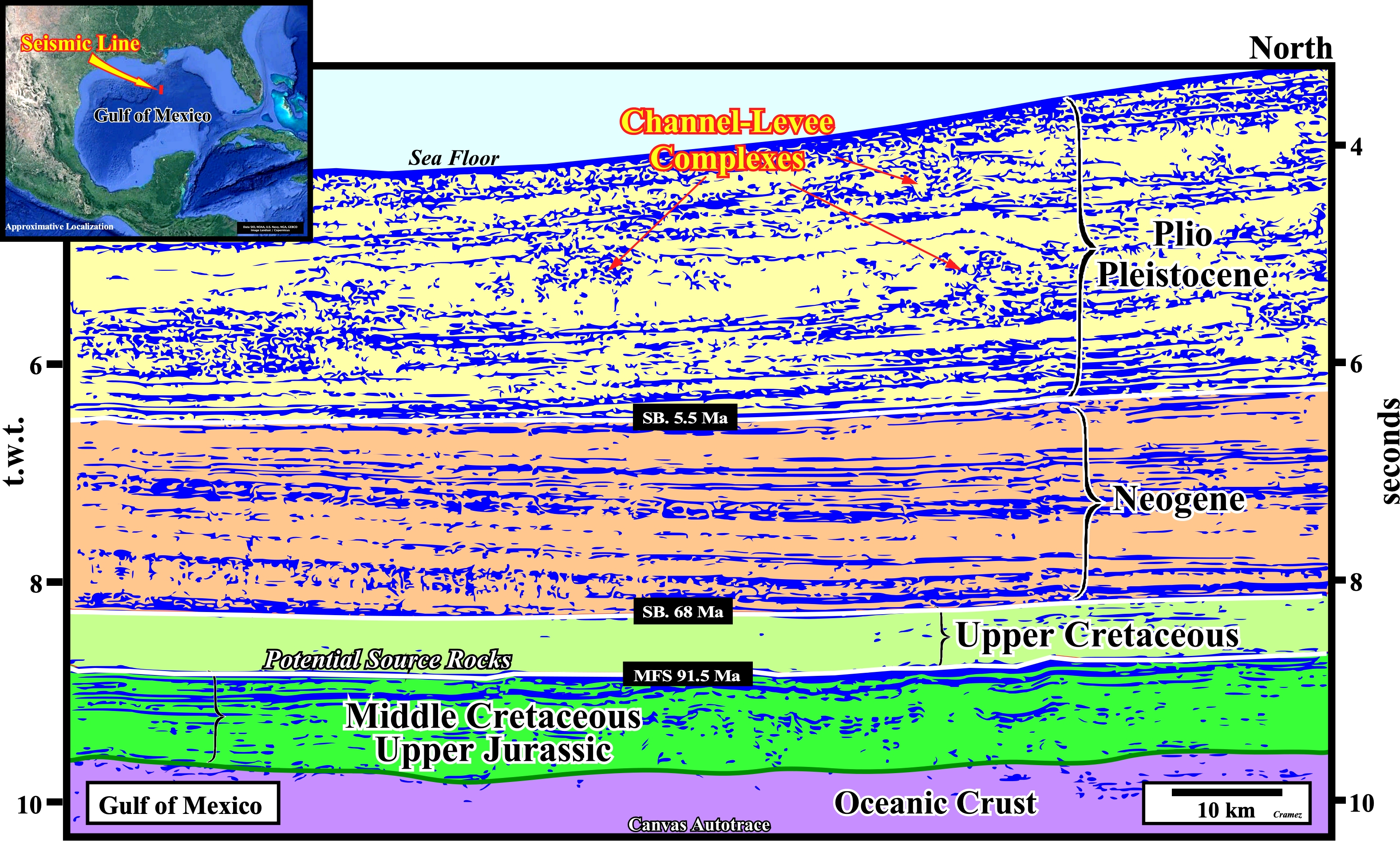
In the deep offshore of the Gulf of Mexico, where the water-depth exceeds 4 seconds (t.w.t.), the only potential reservoir rocks capable of giving economic accumulations are those of Cenozoic age and, particularly, those of the Upper Neogene and Plio-Pleistocene. Such a reservoir-rocks are, mainly, submarine slope fans (channel-levee complexes) deposited in lowstand geological conditions. Some of these channel-levee complexes are, perfectly, recognized even on the Canvas autotraces. The Mesozoic potential reservoirs, which belong to the stratigraphic cycle interval of the generating petroleum sub-system, do not have attractive petrophysical characteristics. In general, in the deep offshore, burial, sediment overload and the importance of non-deposit periods favor the diagenesis of reservoirs. The main marine source rocks are associated to the Cenomanian-Turonian downlap surface (MFS 91.5), which is, roughly, the interface between the transgressive and regressive phases of the post-Pangea continental encroachment stratigraphic cycle.
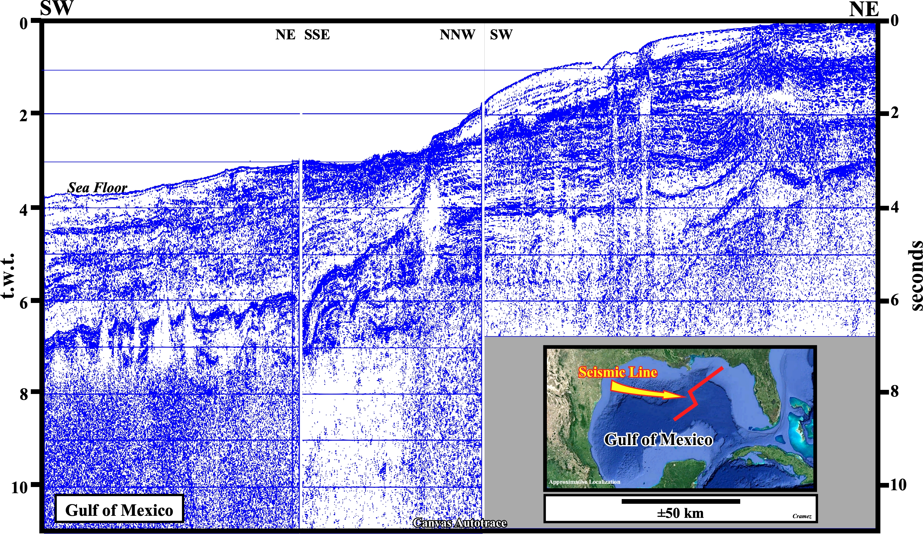
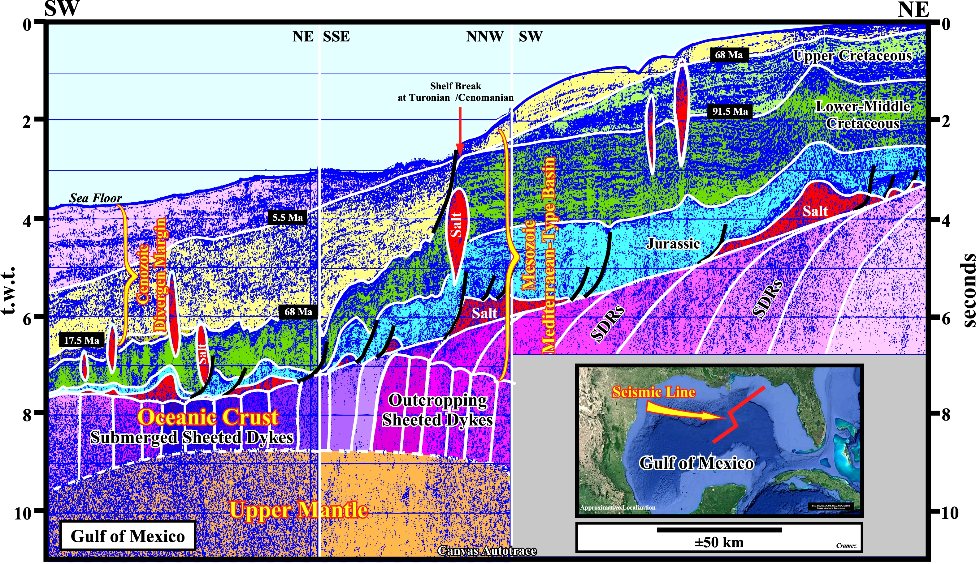
This Canvas autotrace of a composite seismic line of the Gulf of Mexico shows the Jurassic and Cretaceous targets in the deep and conventional offshore. In the deep offshore, particularly, seaward of the Cretaceous shelf break (sharp thickness change of the green interval), the potential reservoir rocks of the Upper Cretaceous, if they exist, will be deep water and shallow water (internal or external platform deposits). The stratigraphic section deposited during the Late Cretaceous, i.e., the regressive phase of the post-Pangea continental encroachment stratigraphic cycle (characterized by a progradational geometry) becomes quite condensed seaward (almost seismically inexistent in deep water). Landward, the thickness of the Upper Cretaceous interval increases, progressively, and its completeness is quite important. In the western part of the section, below the salt induced tectonic disharmony (bottom of the autochthonous salt + salt welds), we recognize the presence of volcanic crust represented here by a layer of submerged sheeted dykes, i.e., by sub-parallel intrusions of mantle material arriving at sea floor where it solidified as pillow lava. In the eastern part of the section, we recognize SDRs (lava flows, i.e., sub-aerial volcanism) and the associated outcropping sheeted dykes, which are the pathways through which the mantle material rose to surface and flows continentward).
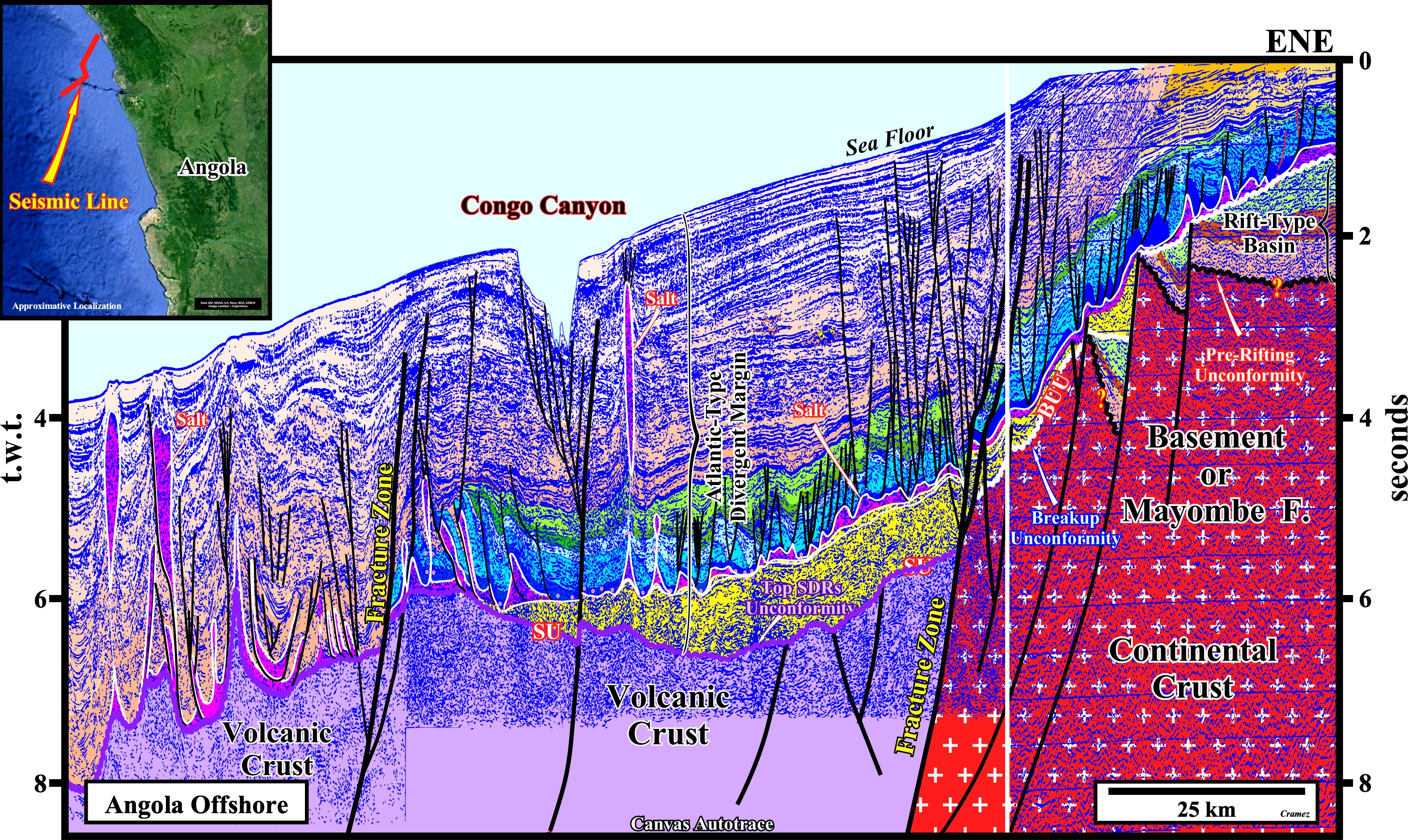
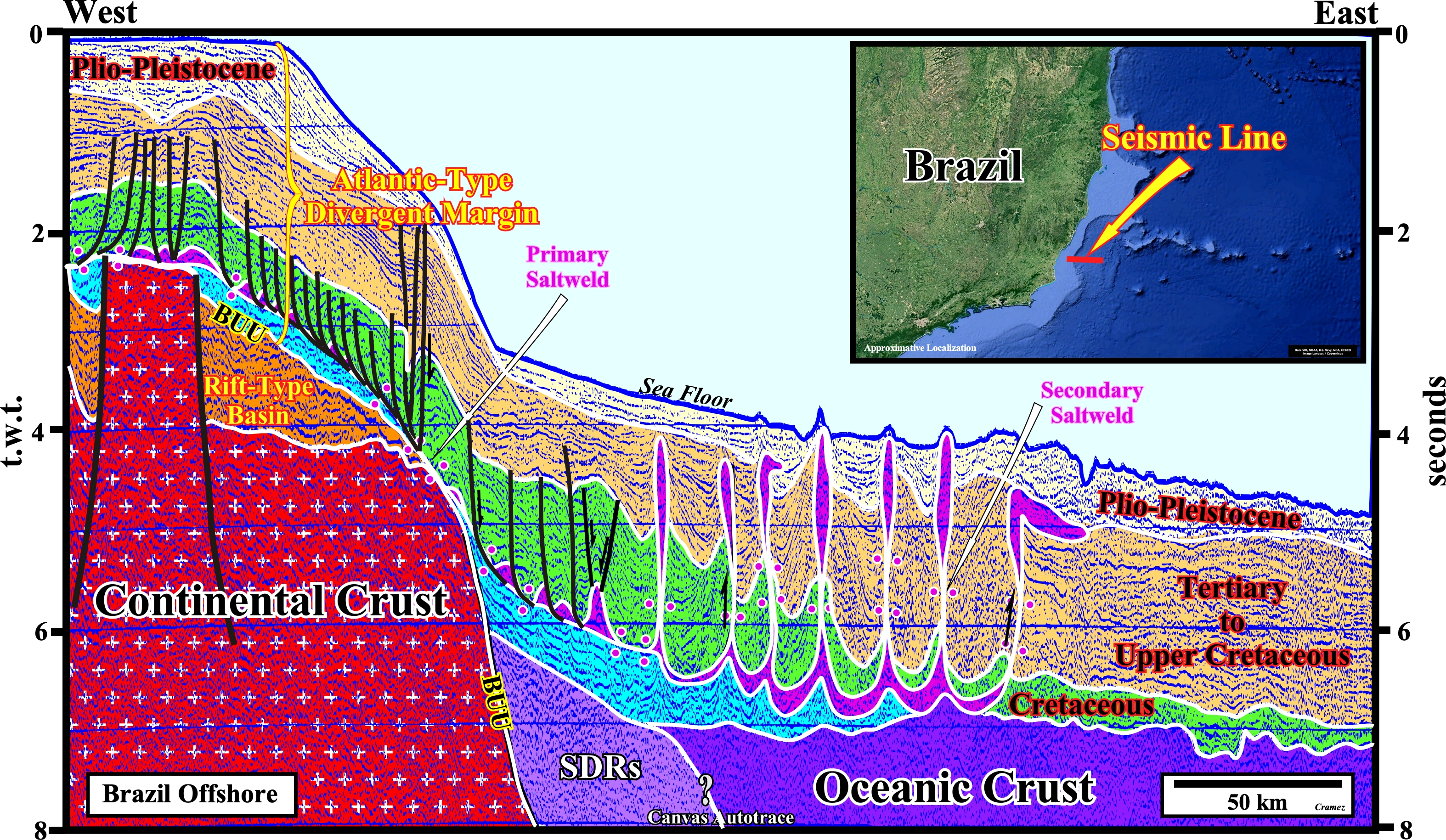
The geological histories of the Angola and Gulf of Mexico offshores are very different. The tentative geological interpretation of a composite seismic line throughout the Northern Angola Offshore (Congo Geographic Basin), depicted above, suggests the potential Upper Cretaceous reservoir rocks (associated with the regressive phase of the Post-Pangea continental encroachment stratigraphic cycle), do not exist in the deep offshore, where such a stratigraphic section is very condensed. On the other hand, the Lower Cretaceous reservoir rocks, which were deposited during the transgressive phase of the continental encroachment cycle, are present all along the Atlantic-type divergent margin. However, their diagenesis is very different. In the distal part of the margin, i.e., in the deep offshore, the burial and the importance of the sediment load made the petrophysical characteristics of the Mesozoic reservoirs very poor. In the proximal part of the margin, where the water-depth is smaller, even taking into account the Tertiary uplift, the characteristics of these reservoir rocks, although not very good, allow the development of the encountered accumulations because the water-depth problems no longer arise. The Cretaceous reservoir rocks, which are the traditional reservoirs in the conventional offshore, were the first reservoir rocks to be tested in the deep offshore. Actually, the target of the first well drilled in this deep offshore was a deep carbonate turtle-back antiform structures. Surprisingly, almost thousand meters before reach the limestone target, the wildcat recognized, by serendipity (as in Brazil offshore), a significant oil-column in Neogene sandstone reservoir rocks were any trapping has been detect before drilling. So, was born, in Angola deep offshore, the oil exploration of turbidite sandstone reservoir rocks in non-structural traps.
We can meet sandstone turbidite reservoir-rocks, with good petrophysical characteristics, in deep offshores, as in the Gulf of Mexico or Congo geographic basins (deposited during the regressive phase of the post-Pangea continental encroachment cycle). In fact, it is essential to have, not very far away, a significant source of sedimentary particles. The presence of an important river, able of supplying the sedimentary material necessary for the gravity currents which will bring it towards the deep parts of the basin (see next plate).
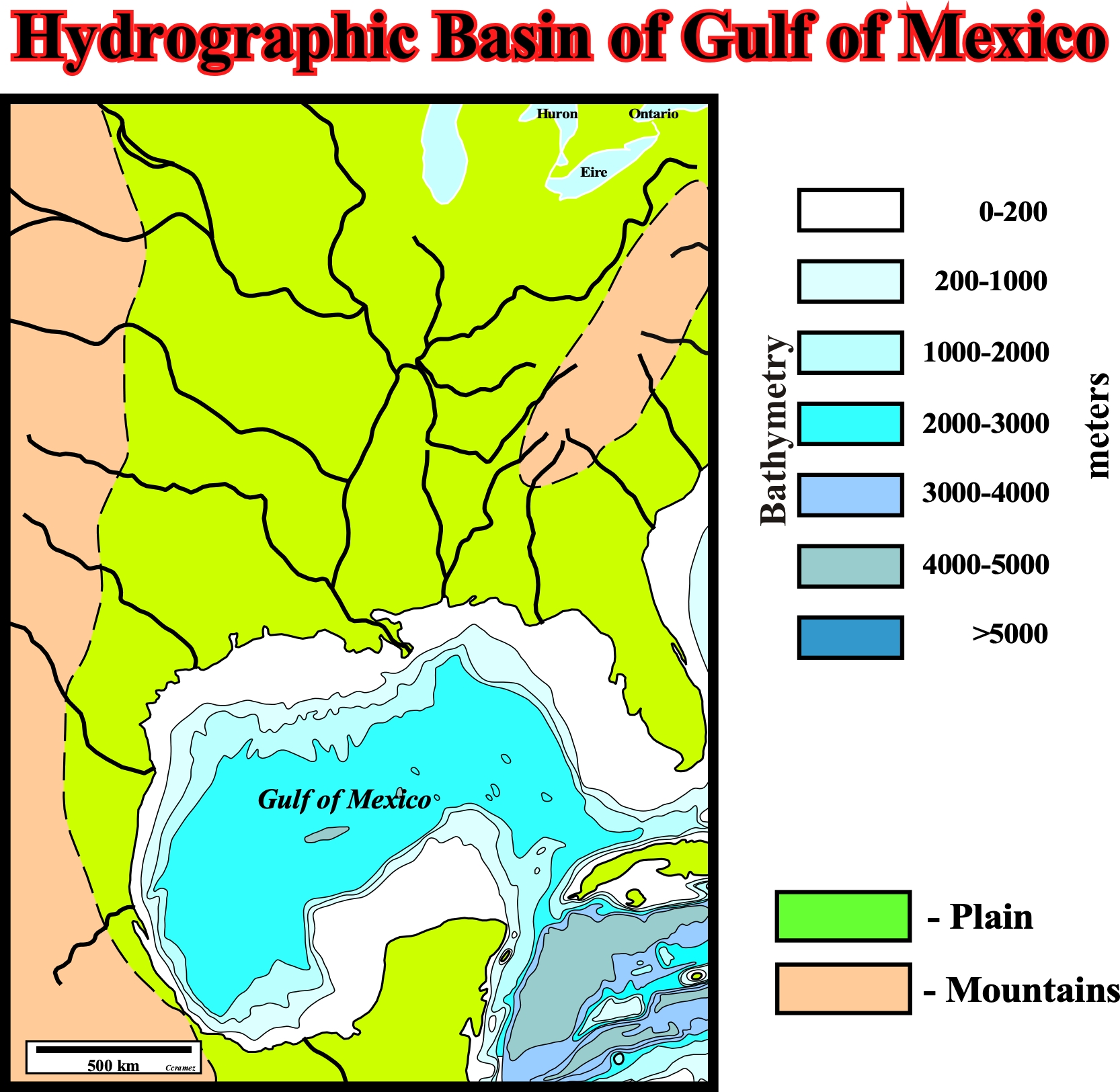
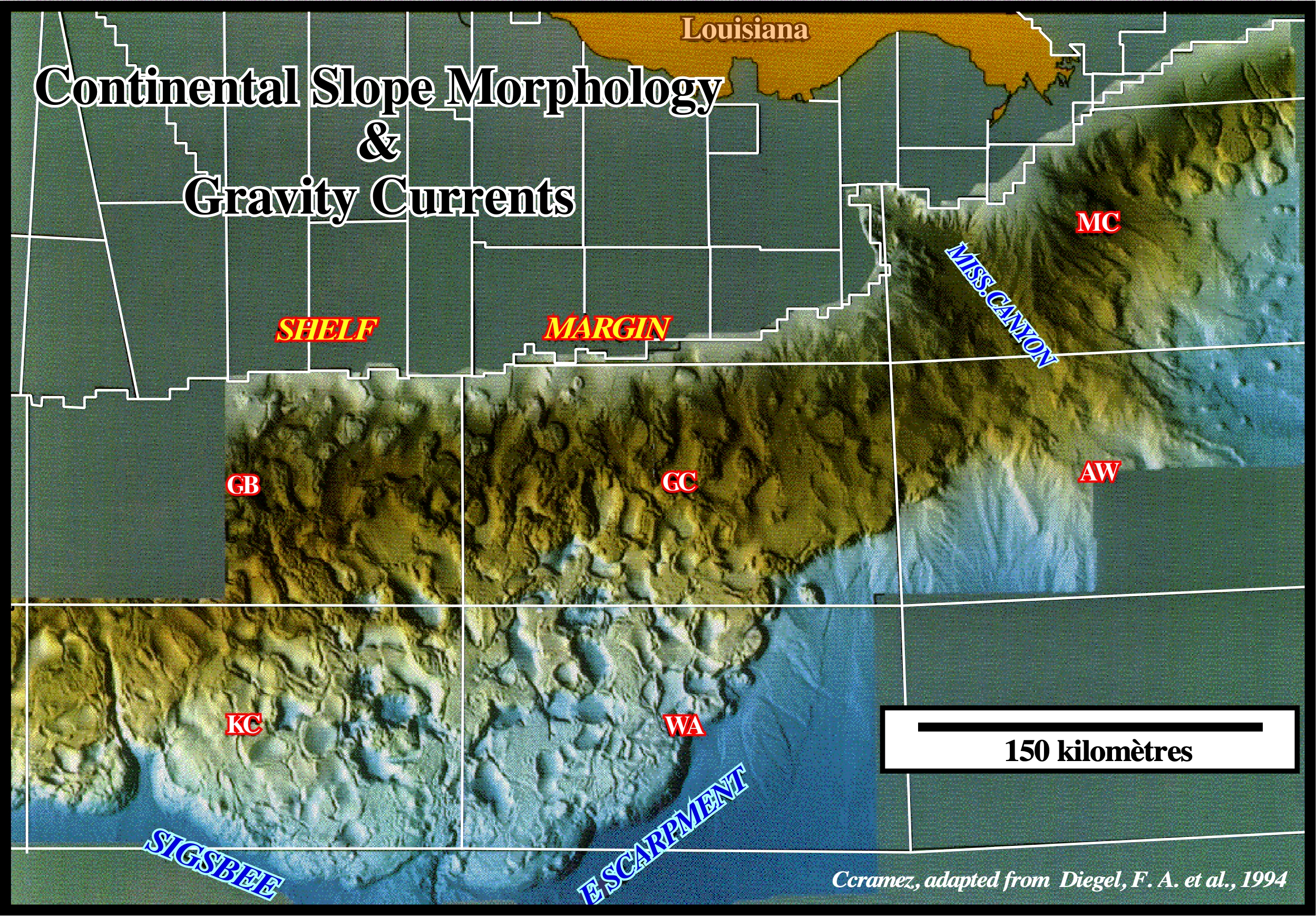
On this sketch, the size of the drainage area of the Mississippi explains, easily, the abundance of sedimentary particles (terrigeneous influx) brought to the Gulf of Mexico, from where the vast majority is transported by gravity currents and deposited or settle, as sediments, under the form of turbidite fans, in the deep parts of the basin. In the Gulf of Mexico, unlike other offshore areas, the absence of a coastal escarpment allowed the Mississippi to move laterally (G. Dailly's pendulum effect) all along its history, particularly, during the Neogene with important consequence to the development of petroleum systems. I would like to insist, on the fact that a sediment is matter (detritus, for instance) that has been deposited by some natural process and not a constituent fragment of a clastic sedimentary rock.
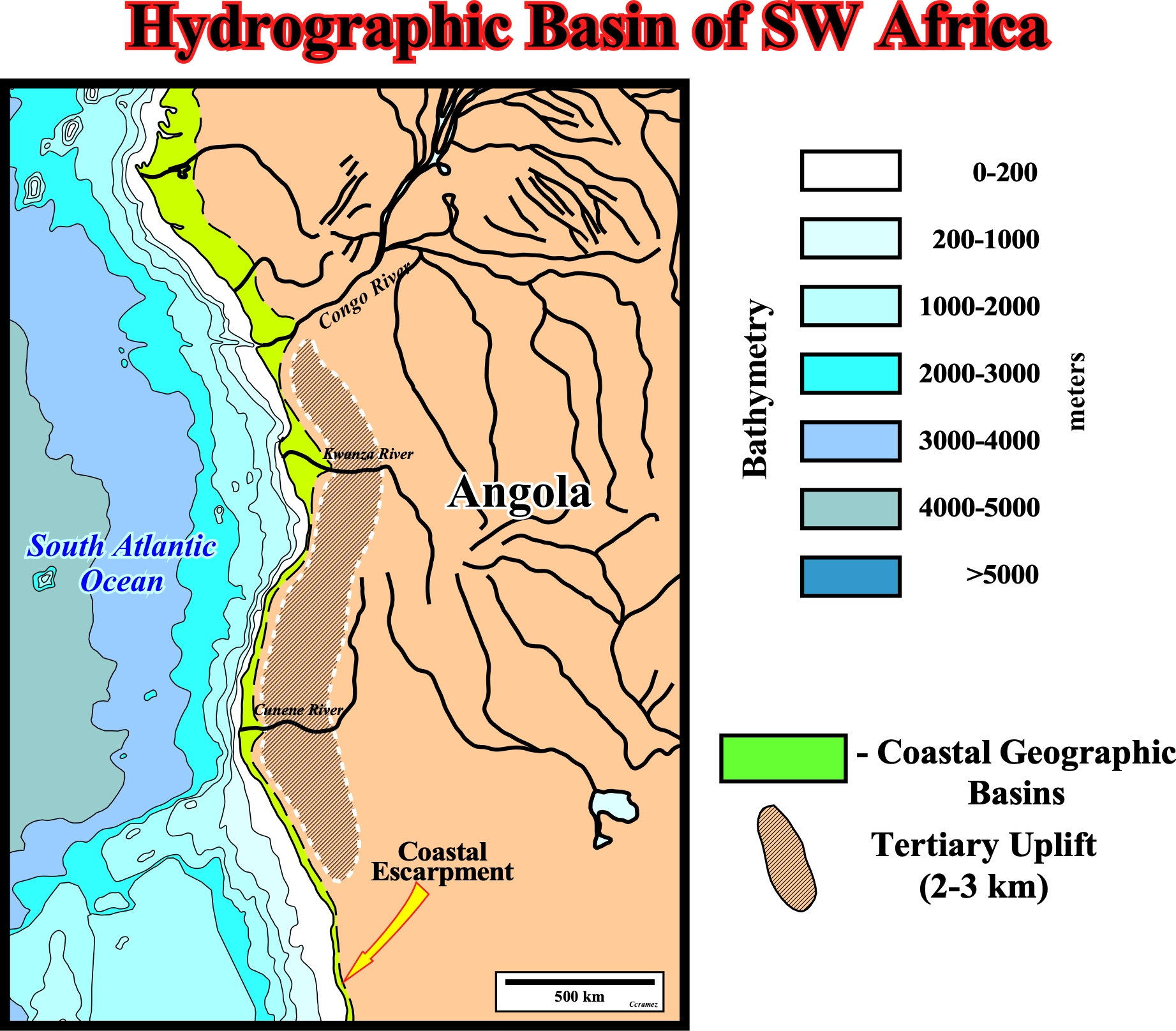
The hydrography of the south-western part of Africa shows, clearly, why the Congo submarine fan (quite well visible on the bathymetry) was formed where it is and not elsewhere. There are significant submarine fans in front of Kwanza or Cunene River. the Tertiary uplift of this part of Africa and the coastal escarpment explain the lack of significant lateral displacements of the Congo ("pendulum effect") during its history. To fully understand the vertical distribution of turbidite reservoir rock and associated non structural traps (mainly morphological), the exact age of the gorge dug by the Congo river across the coastal escarpment, during the Upper Tertiary, must be well known. On the other hand, geoscientists were forced to sub-divide the sedimentary column in front of the Congo mouth river in two large regressive (retrogradational) intervals. The lower one, totally, independent of the Congo sedimentary supply, since the river did not yet exist in its current form, and the upper one, totally, associated with the current Congo river.
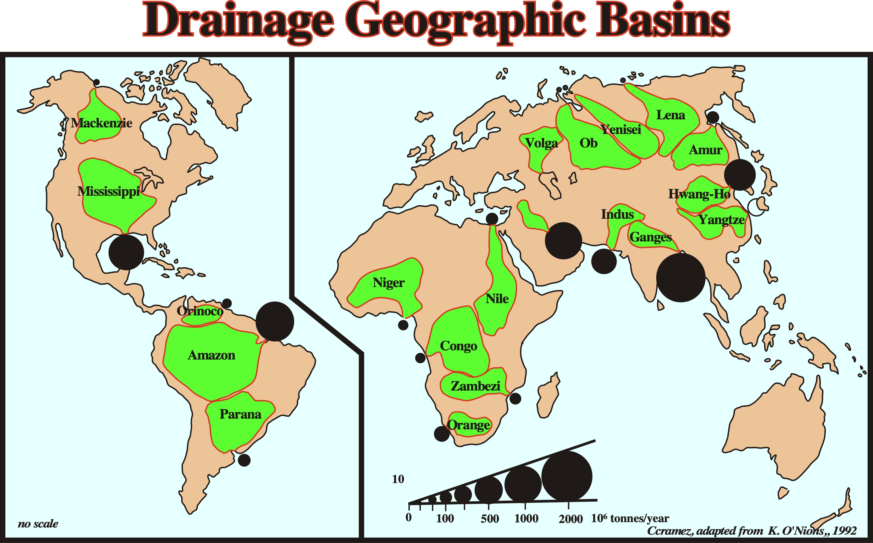
On this subject (terrigeneous influx), it is important to take into account the mapping of the main current drainage basins (next plate), which should not be very different from that of Tertiary. The drainage basins map illustrated below shows, clearly, that Brazil's offshore is not the opposite sidewalk of the West African offshore, as lot of geoscientists still think.
On this map, it is interesting to note thta in the West Africa offshore the only significant terrigeneous supply is associated with Niger, Congo and Orange rivers, while in eastern South America just the Orinoco, Amazonas and Parana rivers bring significant terrigeneous supply into the sea. Thus, from the point of view of potential turbidite clastic reservoir rock, the Congo offshore has not been equivalent (in time) on the other side of the South Atlantic. This hypothesis is corroborated by the bathymetry (next plate) and by the seismic data of these offshores (fig. 9 and 10). On the other hand, a present time, into South America just the Amazon river brings to the sea more than 1000 x 106 tonnes / year of terrigeneous material.
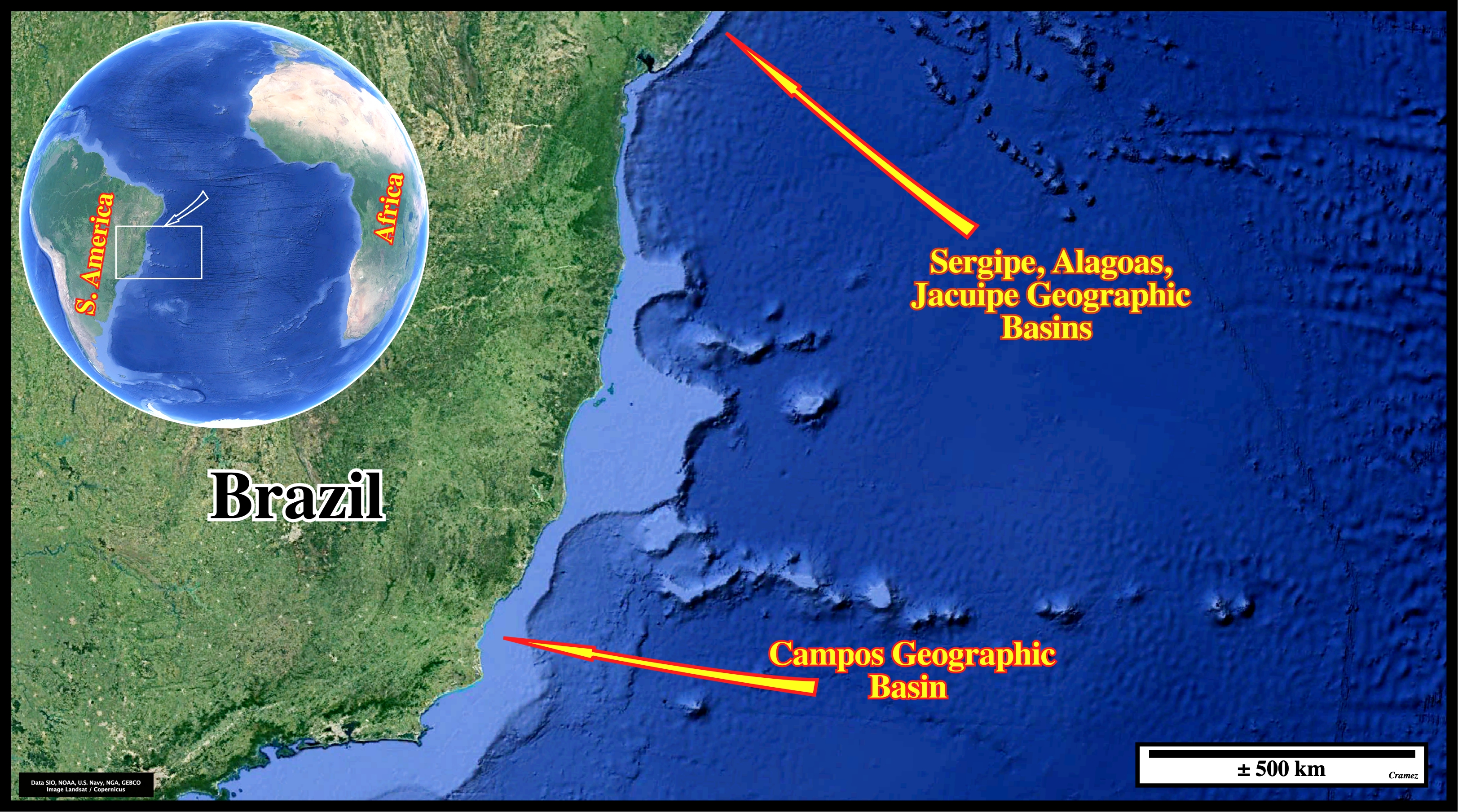
The bathymetry depicted on this map, suggests, that presently and probably during the Tertiary, the growth of the South America continent was reduced to a minimum. Apart from the emplacement of lava complex, in the Abrolhos region (north of the Campos basin) and the SDRs (post-breakup sub-aerial volcanism) on the Santos and Pelotas offshores (southward of Campos geographic basin), the regressive Tertiary sediments have, hardly, built a continental platform. This can be seen on the seismic lines (next autotraces) taking into account the relatively small thickness of the regressive phase of the post-Pangea continental encroachment stratigraphic phase induced by the falling of the absolute sea level that occurred since the Cenomanian/Turonian. I remind the absolute sea level is referenced to a fixed point, which is, generally, the Earth's center and that it rises or falls, mainly, function of the volume of the oceanic basins and volume of the ice sheets and ice caps (glaciers included), since the water volume, under all its forms (solid, liquid and gaseous), is considered constant since the Earth's formation, around 4.5 Ga (4.5 x 10⁹ years ago, i.e., since the Earth's formation).
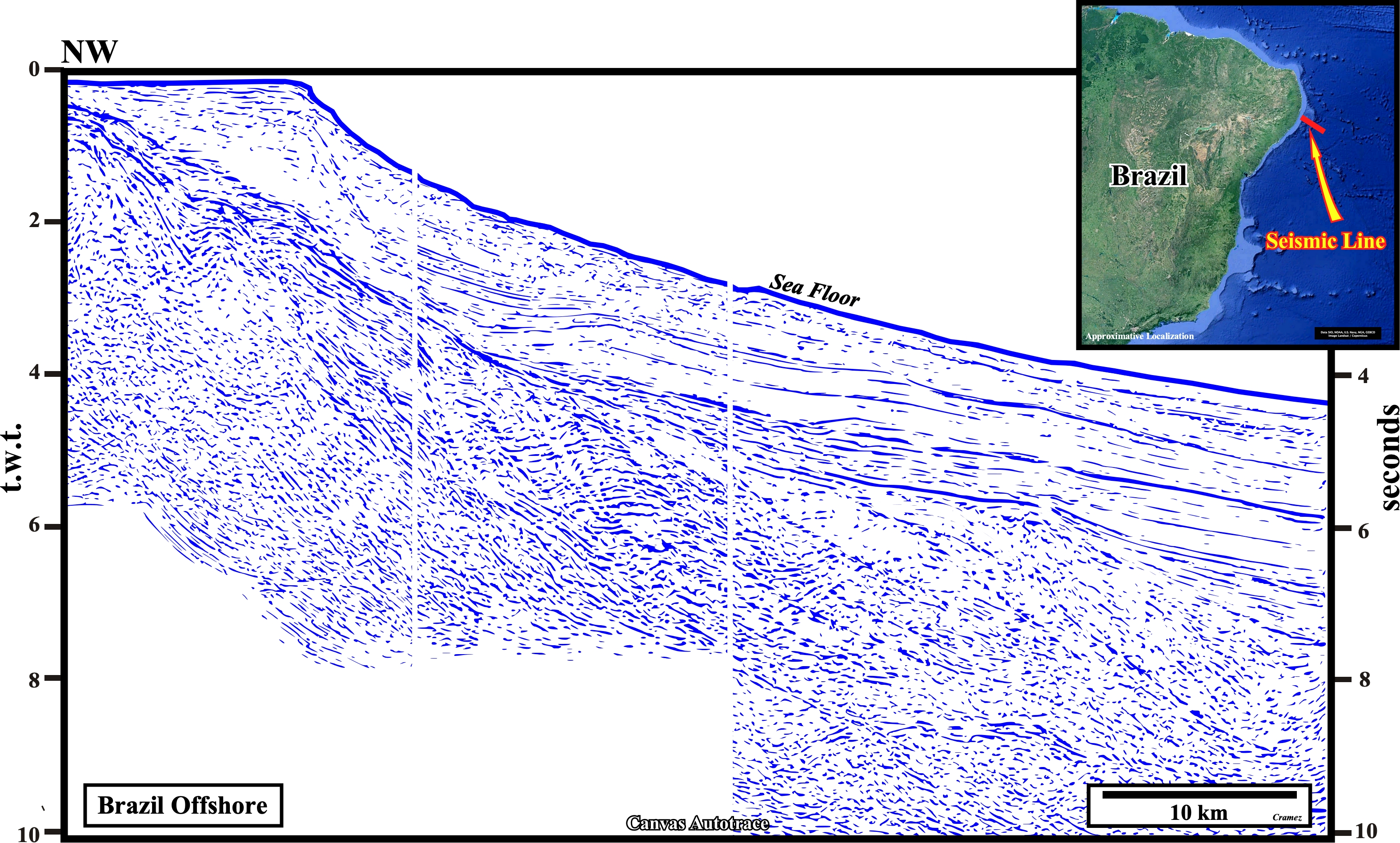
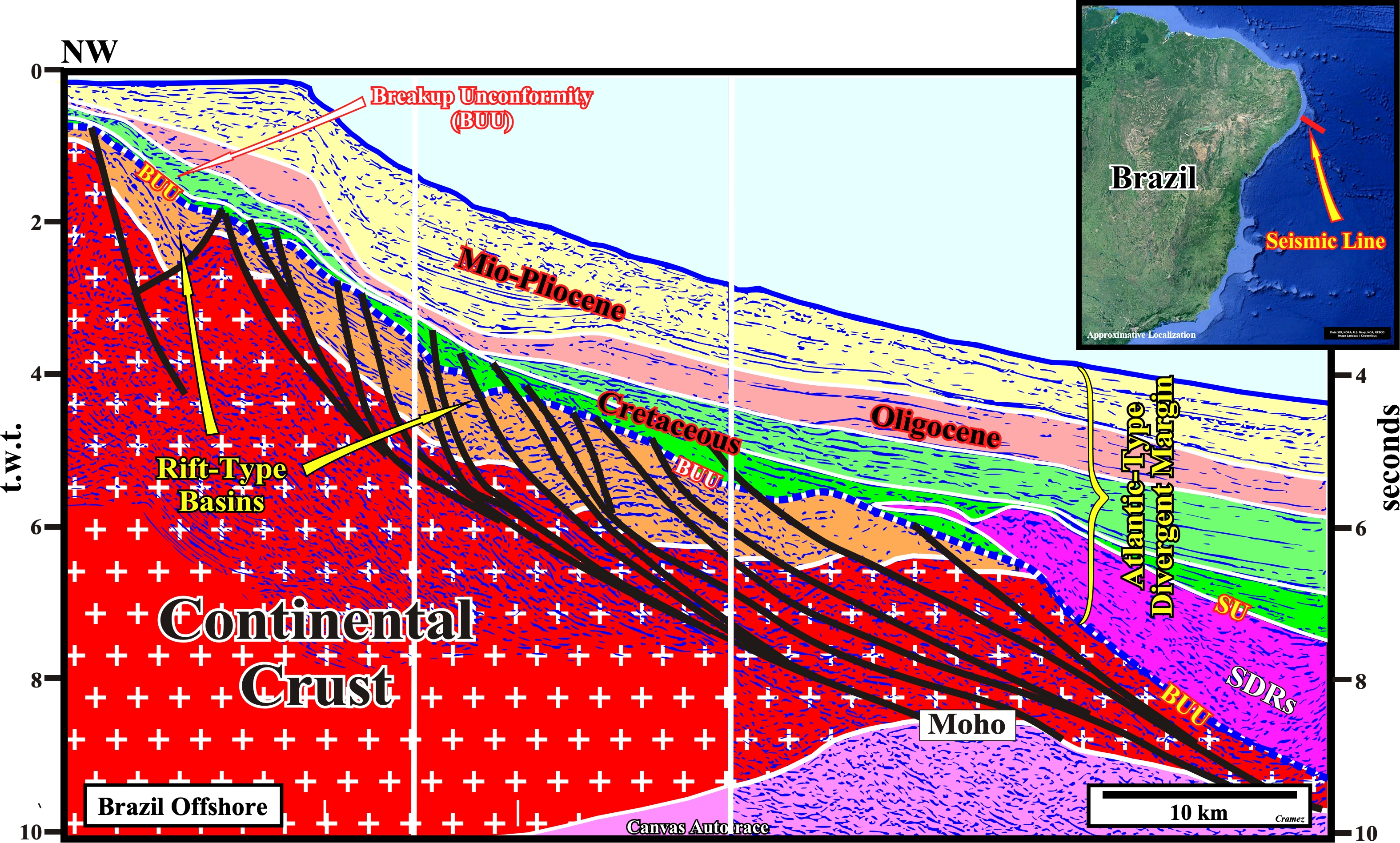
On this tentative interpretation of a Canvas autotrace of seismic line of the Sergipe / Alagoas geographic basins, it is evident the thickness of the Tertiary sediments, which does not even reach 1 seconds (double time), does not refute the hypothesis invoked previously, i.e., the Brazil offshore, from the point of view of the petroleum reservoir parameters, is not the opposite sidewalk of the Southeastern Africa offshore. This is, particularly, true in the Congo River offshore, were Tertiary turbidite reservoir -rocks are paramount. Take note that on this tentative geological interpretation, the breakup unconformity (BUU), in the eastern part of the basin is fossilized by SDRs, i.e., by lava flows emplaced just after the breakup of the Pangea lithosphere while the expansion centers were still sub-aerial. On the other hand, the eastern dip of the sediments is quite exaggerated by the seismic pitfall introduced by the abrupt and progressive eastward change in the water depth.
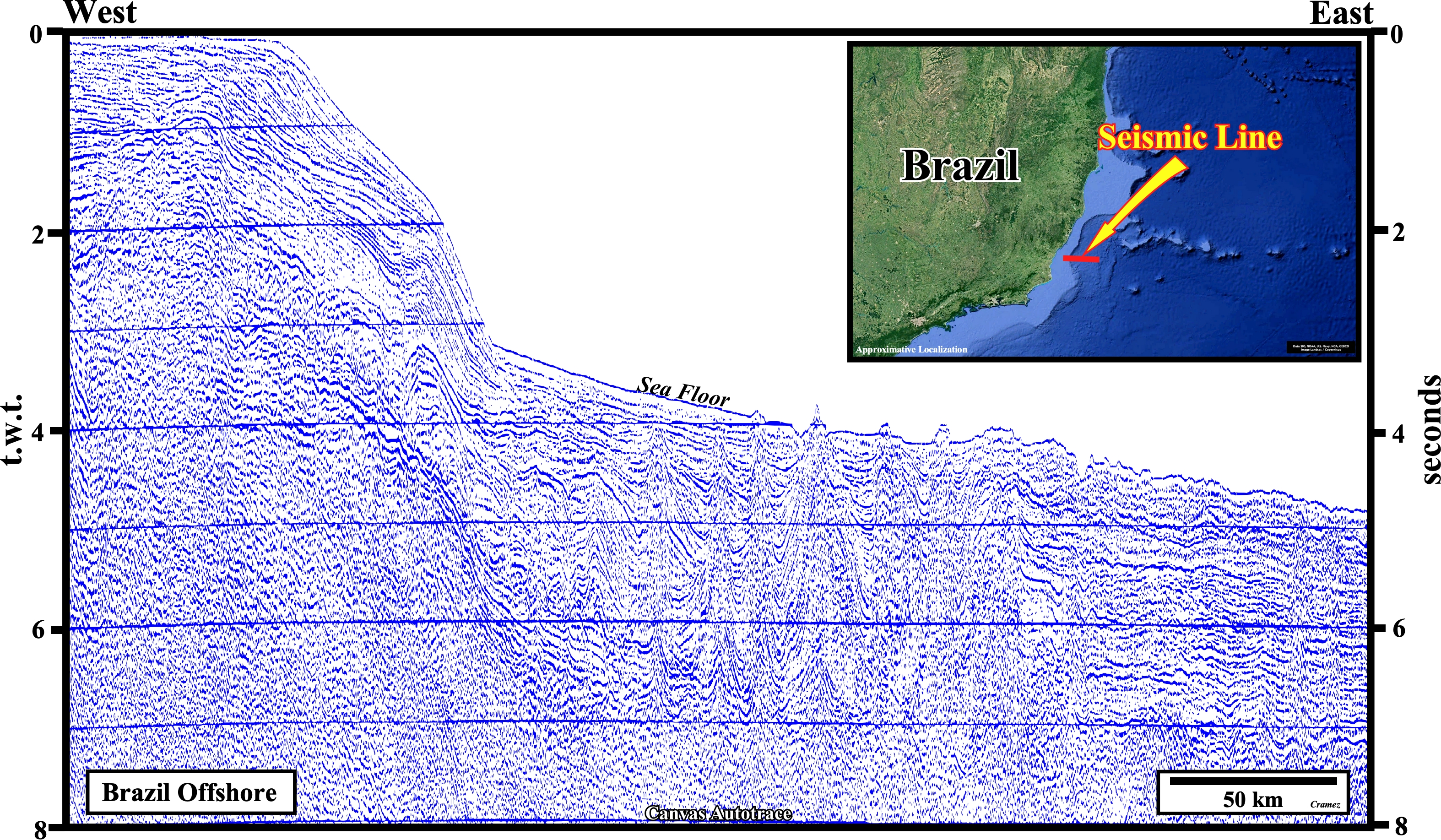
The seismic data of the Campos offshore, such as the Canvas autotrace of a regional seismic line illustrated here and, particularly, its tentative geological interpretation, corroborate the hypothesis advanced previously, i.e., the relatively small thickness of the progradational phase of the continental encroachment stratigraphic cycle. This implies in the absence of major rivers capable of feed the turbidite currents with clastic material, which is the case of the East Brazil offshore, the presence of Tertiary sandstone rich turbidite reservoir rocks is unlikely. The Meso-Cenozoic boundary is very poorly marked and, probably, the Cenozoic sediments are, practically, reduced to those of the Plio-Pleistocene. On the other hand, the thickness of the Cretaceous deposits and, particularly, those of the regressive deposits postdating the major downlap surface, i.e., those which age is posterior to Middle Turonian (MFS 91.5 Ma), is important. This seems to indicates that in the Upper Cretaceous, in the Campos geographic basin, there was an important river capable of providing enough terrigeneous supply to allow a significant progradation of the continental slope break. Remind, on the West Africa offshore, unlike what happens in the Campos geographic basin, the Upper Cretaceous sediments are, quickly, condensed seaward.
II- Turbidite Deposits
We know the hydrocarbon accumulations to be developable, under a large water-depth, require reservoir rocks with satisfactory petrophysical characteristics such the sandstone turbidite reservoirs (GOM, Angola) and under certain conditions carbonate turbidite (Campeche / Caiaphas). It seems interesting to recall some basic notions of turbidite sandy deposits, without going into the details.
a) By definition, turbidite deposits are formed when gravity currents, which bring the sedimentary particles from the platform towards the deep parts of the continental slope or towards the abyssal plain, decelerate and lose competence, i.e., when they no longer have the strength to transport the terrigeneous supply.
b) The speed of gravity currents is very dependent on the morphology of the seafloor, which can accelerate them, i.e., increase their competence (no deposition), or decelerate them, i.e., decrease their competence, which implies, necessarily, a partial or total deposition of the terrigeneous material.
This figure, which illustrates the morphology of the seabed in the Gulf of Mexico, clearly, illustrates how the bathymetry can influence the speed of the gravity currents (turbidite currents). In the upper part of the continental slope, the bathymetric anomalies induced by salt tectonics decelerate, locally, the gravity currents and force certain sedimentary particles to settle. On the other hand, in the lower part of the continental slope or in the abyssal plain, the absence of halokinesis, allows a very regular seabed morphology, which gives a total freedom to turbidite currents. This freedom allows the turbidite system to organize itself, i.e, to become SOC ("self organized critically system"). We will show seismic examples of these two types of turbidite deposits which, being very different, naturally, have very different petroleum potentials.
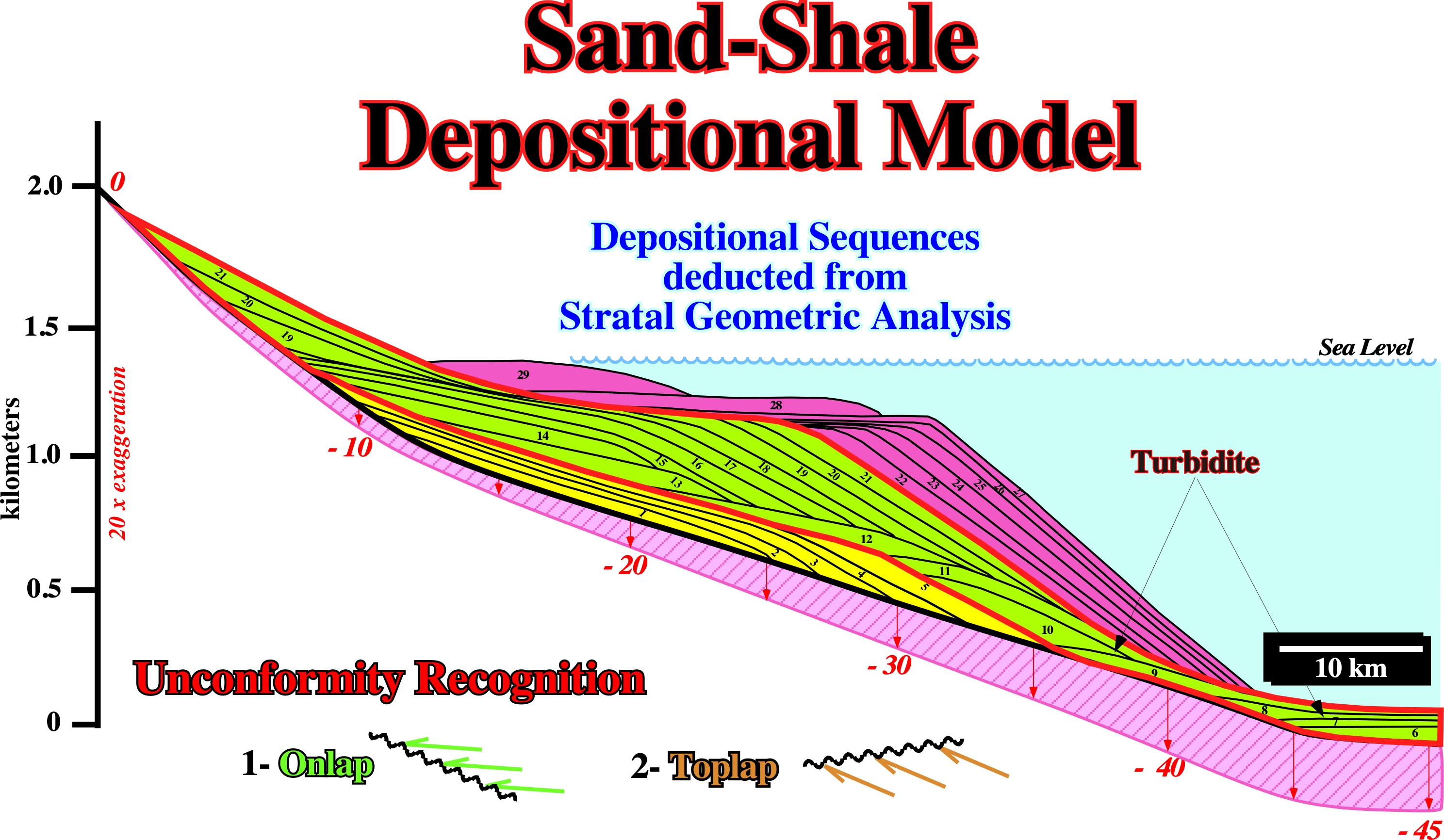
When there are no great obstacles to the passage of gravity currents, these have a great degree of freedom and, therefore, they follow SOC's laws (Prigogyne I., 1997, The End of Certainty; P. Bak., 1996, How Nature Works) building-up typical submarine fans ("Sandpile models") conforming to the geological model predicted and described by P. Vail and his co-authors (next plate).
This figure, taken from P. Vail (1977), illustrates the depositional model of a stratigraphic sequence cycle, which time-duration is about 3 million years and bounded by unconformities and correlative paraconformities in the deepest parts of the basin, colored in red. In fact, it illustrates a sedimentary event snapshot at the geological scale (Gretner, 1968), since its duration is less than 1:100 of the total geological duration of the Phanerozoic. From bottom to top, in this model we recognize : (i) Submarine basin floor fans ; (ii) Submarine slope fans made up of a progradational complex set of channels and overbank deposits ("channel-levee complex") ; (iii) The lowstand prograding wedge ; (iv) The transgressive interval (highstand geological conditions), and finally (v) The highstand prograding wedge. The gravity currents responsible of the lowstand deposits (submarine fans and lowstand prograding wedge) have a maximum degree of freedom. The sedimentary system is organized by itself, i.e., the depositional system is "Self Organized Critically System" (SOC in P. Bak's terminology). On the other hand, this model can be declined in two modes. In the first, the submarine slope fans are superimposed on the submarine basin floor fans, which can remove all prospectivity from the latter and explains the accumulations in the slope cones (next figure). In the second, rather rarer, the submarine basin floor fans are detached, i.e., they are not covered by the submarine slope fans and so they can become very good traps and potential reservoirsrocks.
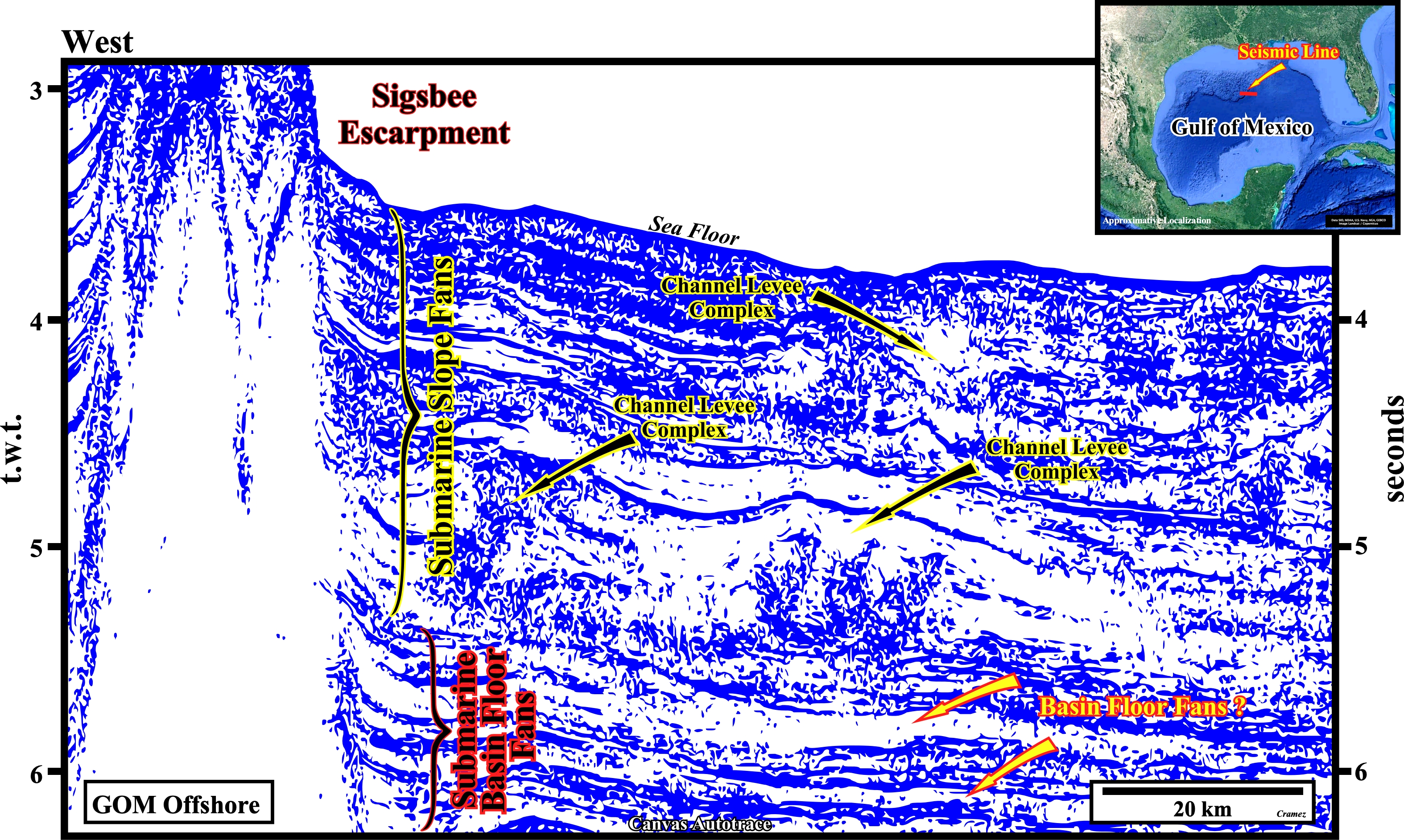
On this Canvas autotrace of a Gulf of Mexico seismic line, located downstream of the Sigsbee escarpment, i.e., beyond the zone where there is an intense halokinetic activity induced by autochthone & allochthonous salt layers, set up in the Upper Neogene (part west of the seismic line), illustrates the typical organization of lowstand deposits as described by P. Vail.
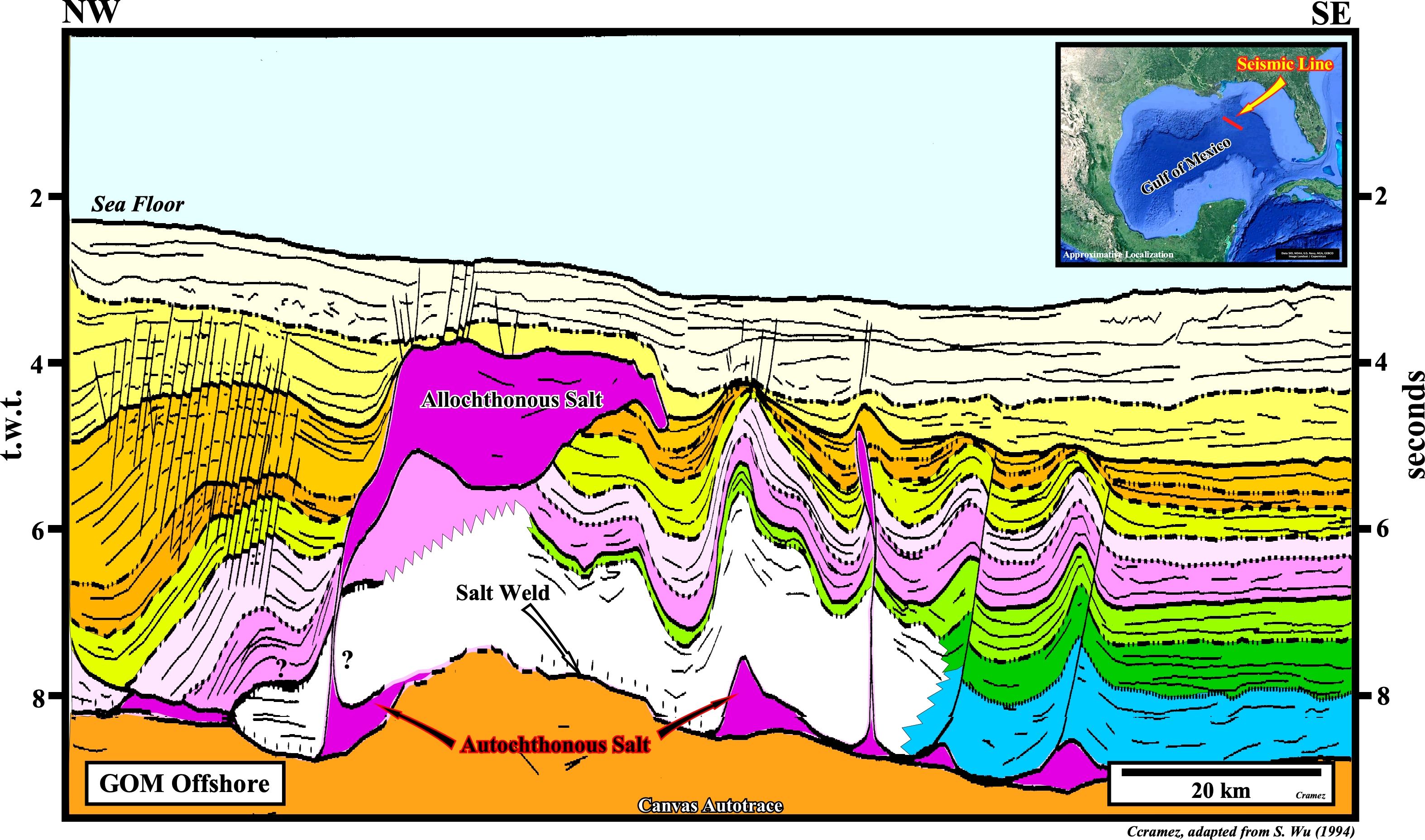
Contrariwise to what happens in the distal part of the preceding seismic line, where the turbidite deposits are organized by themselves according to the laws of nature ("sandpile model" by P. Bak), in the proximal part of this tentative geological interpretation of a manual autotrace of a regional seismic line of the Gulf of Mexico, upstream of the allochthonous salt nappe, turbidite currents are disturbed by salt movements, which induce negative iterations, in the same way that a thermostat works to maintain constant the room's temperature.
In the study of turbidite deposits, it is, extremely, important not to forget that turbidite systems are dissipative structures in the sense proposed by I. Prigogine. A turbidite system is not only an open geological system. In the trajectory of a current, there are points of instability from which new structures and forms of a sedimentary order can emerge. The gravity currents are maintained in a critical stable state, but far from the point of equilibrium. Thus, far from equilibrium, the flows are stronger, entropy increases and the system no longer tends towards equilibrium. On the contrary, it can encounter instabilities that lead it to new forms of order and which move it further and further away from equilibrium. Thus, far from a state of equilibrium, dissipative structures, such as gravity currents, can develop increasingly complex shapes.
The characteristics of turbidite deposits cannot be derived from the properties of its components, they are the consequence of its overall organization. The detailed study of electrical logs, independent of that of seismic data and geological contexts (local, regional and global) will never allow a geoscientist to make valid prediction, which are, just, possible after understanding the whole. We must start from the general to the particular and not from the particular to the general, as many geoscientist working in petroleum exploration often claim.
In reality, each geological model proposed for turbidite deposits is an ad hoc model. It is only valid for a specific case. Any generalization is dangerous. This is also true, even for currents with an almost total degree of freedom (Vail model), because even in this case the system can have bifurcation points with emergence of new structures and forms.
![]()
![]()
Send E-mails to carlos.cramez@bluewin.ch with comments and suggestions to improve this atlas.
Copyright © 2001 CCramez
Last update:
2022
![]()