.jpg)
.jpg)
Mauritania Offshore
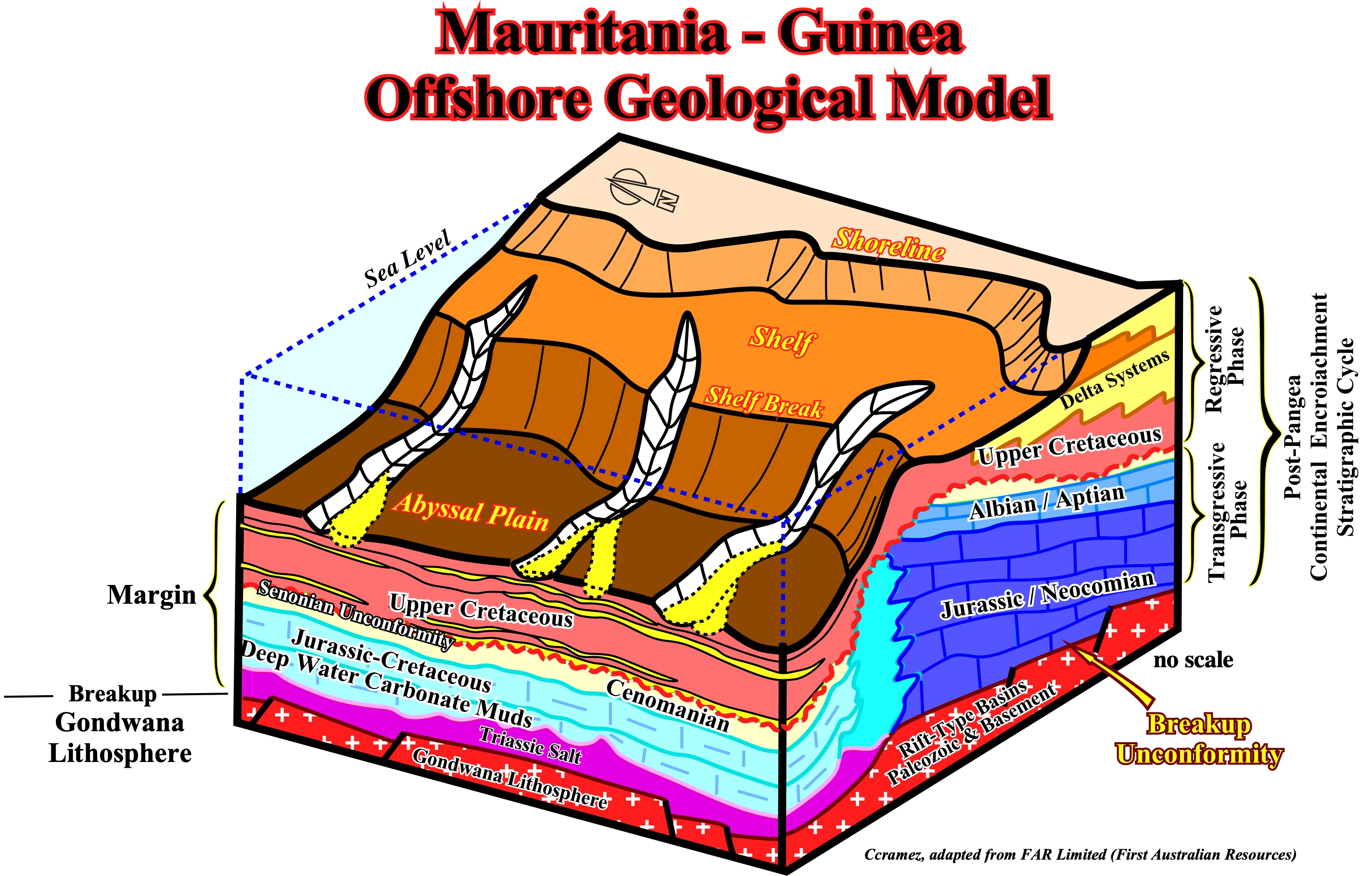
This block diagram illustrates the geological configuration of the post Pangea continental encroachment stratigraphic cycle in the Mauritania-Guinea offshores. Above the breakup unconformity, which is the upper boundary of the pre-rifting and rift-type basin rocks, a Triassic salt layer was deposited in a confined shallow water depocenter, apparently, from potash enriched brines due to the spilitization of sub-aerial volcanism (lava flows, i.e., SDRs). Then, due to absolute sea level rise, induced by the volume reduction of the oceanic basins created by the emplacement of the oceanic ridge, carbonate sediments of the transgressive retrogradational phase were deposited. During this stratigraphic phase, the shoreline was, progressively, displaced continentward, while the successive shelf-breaks were, more or less, stacked in a still-stand position (upbuilding) creating an abrupt deep water geological setting, i.e., an abrupt change between the shelf and abyssal plain environments with a quite steep continental slope. Since the absolute sea level started to fall, due to the volume reduction of the oceanic basins induced by the subduction of the oceanic crust along the subduction zones and the continental collision, i.e., during the regressive phase of the post-Pangea continental encroachment stratigraphic cycle, submarine basin floor and slope fans deposited in the deeper parts of the basin. As depicted in next plate, major downlap surface (DS. 91.5 Ma) limits the two stratigraphic phases characterized, respectively, by a retrogradational or backstepping geometry fossilized by a progradational or forestepping geometry. Consequently, in the regressive phase, potential turbidite depositional, which may form excellent entrapment-migration petroleum subsystems, which can be feed by potential deep-water source-rocks intervals.
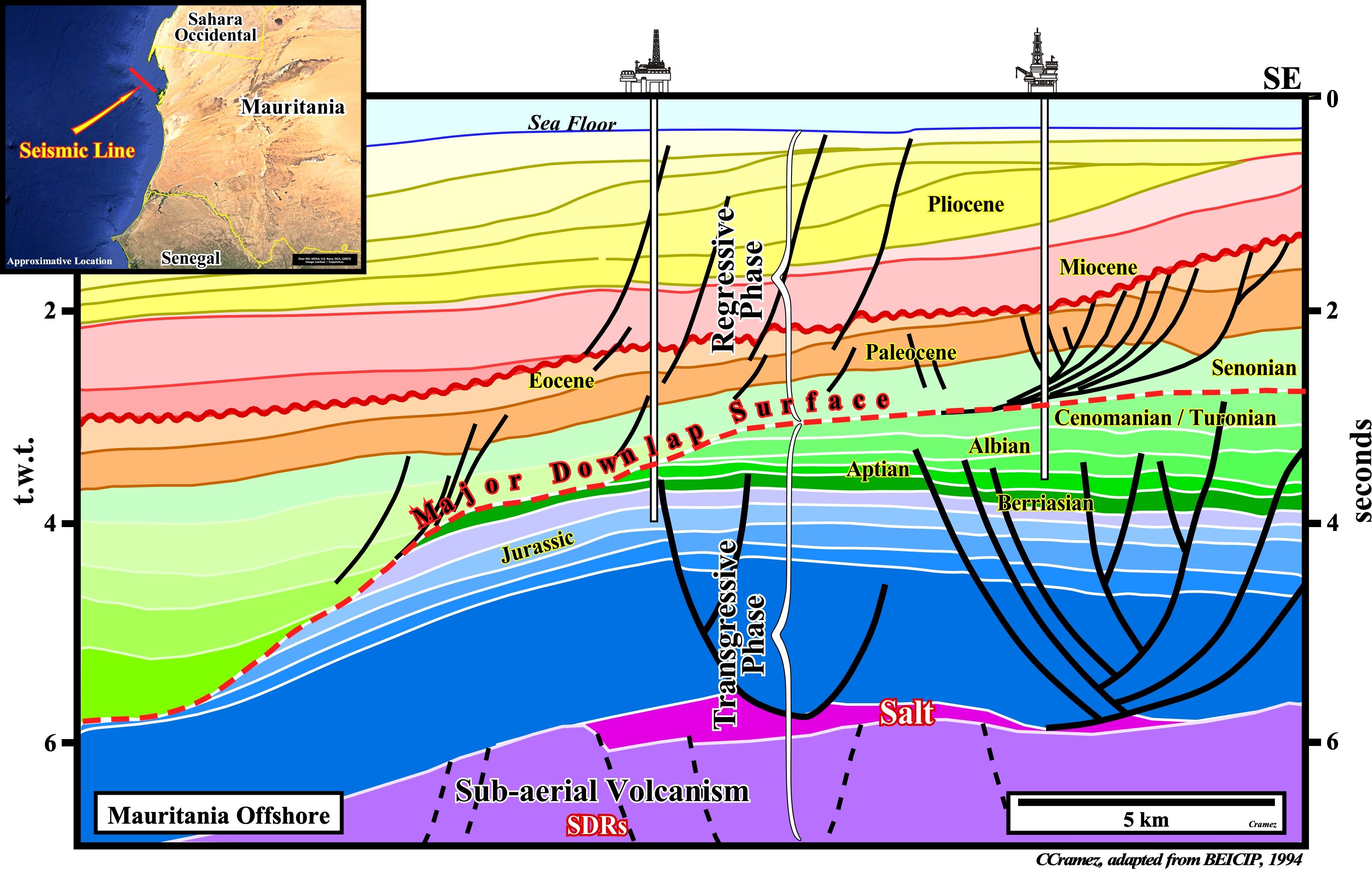
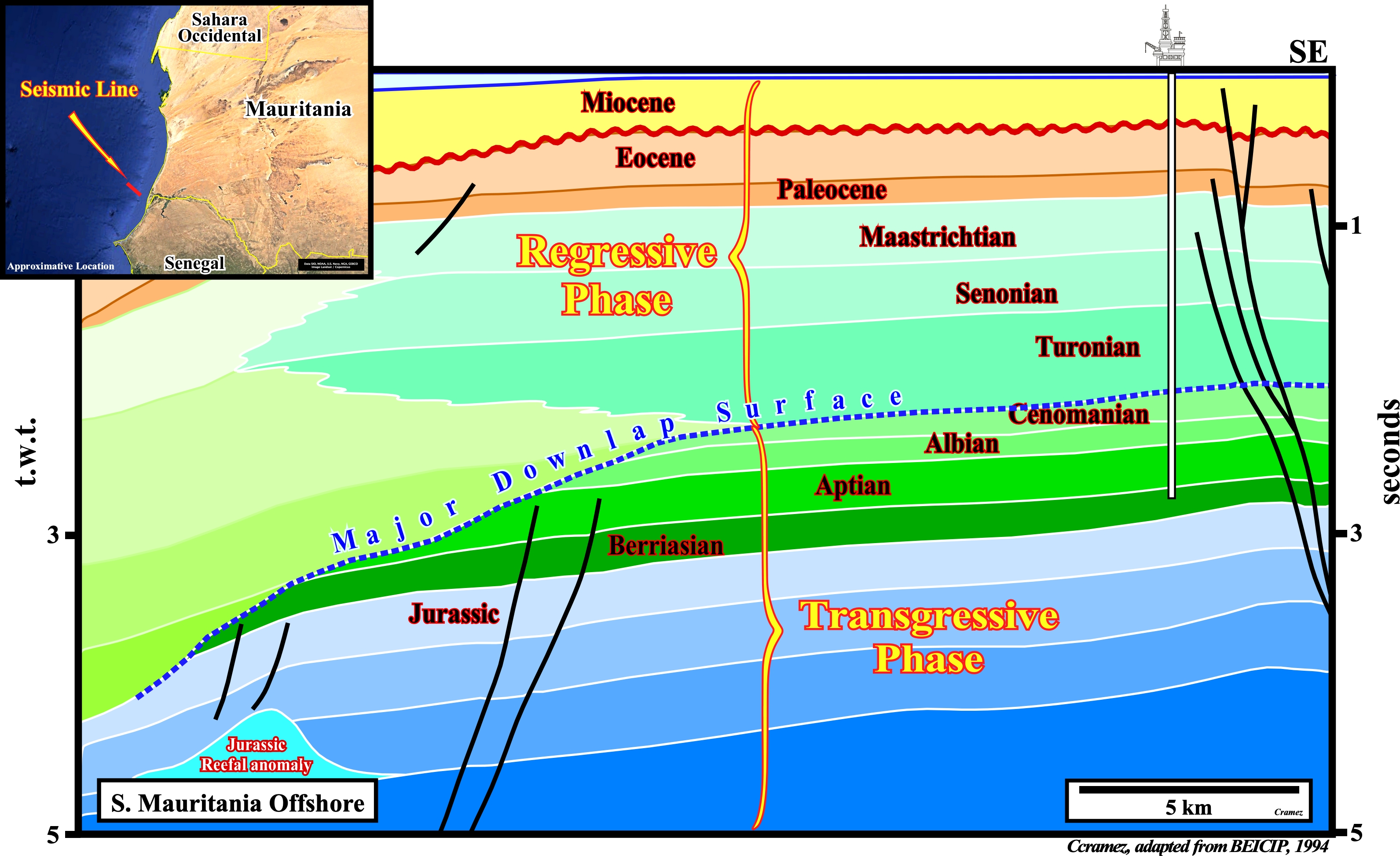
These tentative geological interpretations of Mautitania offshore seismic lines corroborates the geological model assumed previously. The major downlap surface (DS. 91.5 Ma) separates the transgressive and regressive phases of the post-Pangea continental encroachment stratigraphic cycle. The transgressive phase has a retrogradational or backstepping geoemtry and it thickens continentward before onlapping. At the end of the transgressive phase, the distance between the shelf break and the shoreline is at its maximum, which develops in the distal parts of the shelf condensed stratigraphic section that can be riched in organic matter (potential marine source-rocks). Reefal Jurassic anomalies can develop near the shelf breaks. At the bottom of the transgressive phase, a Triassic salt layer deposited over sub-aerial lavas-flows (sorry from the tautology, lava cannot flow underwater). The lava-flows seem to correspond to SDRs (acronym of Seaward Dipping Reflectors) emplaced after the breakup of the lengthened Gondwana lithosphere. The regressive phase has a progradational or forestepping geometry and it thickens seaward before disappear by downlap (see next plates). Potential deep water petroleum systems can develop in the distal part of the basin, with turbidite entrapment-migration petroleum subsystems and deep water generating petroleum sub-systems.
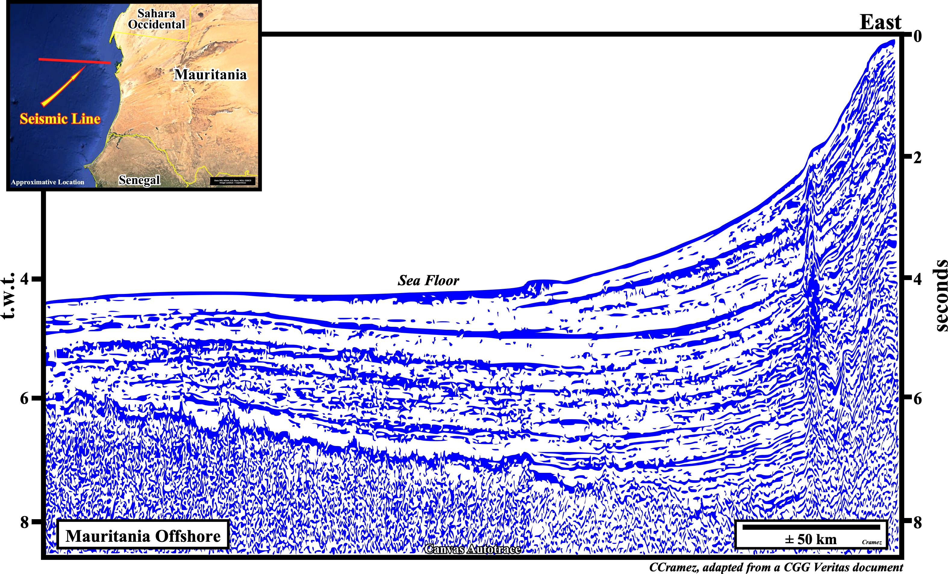
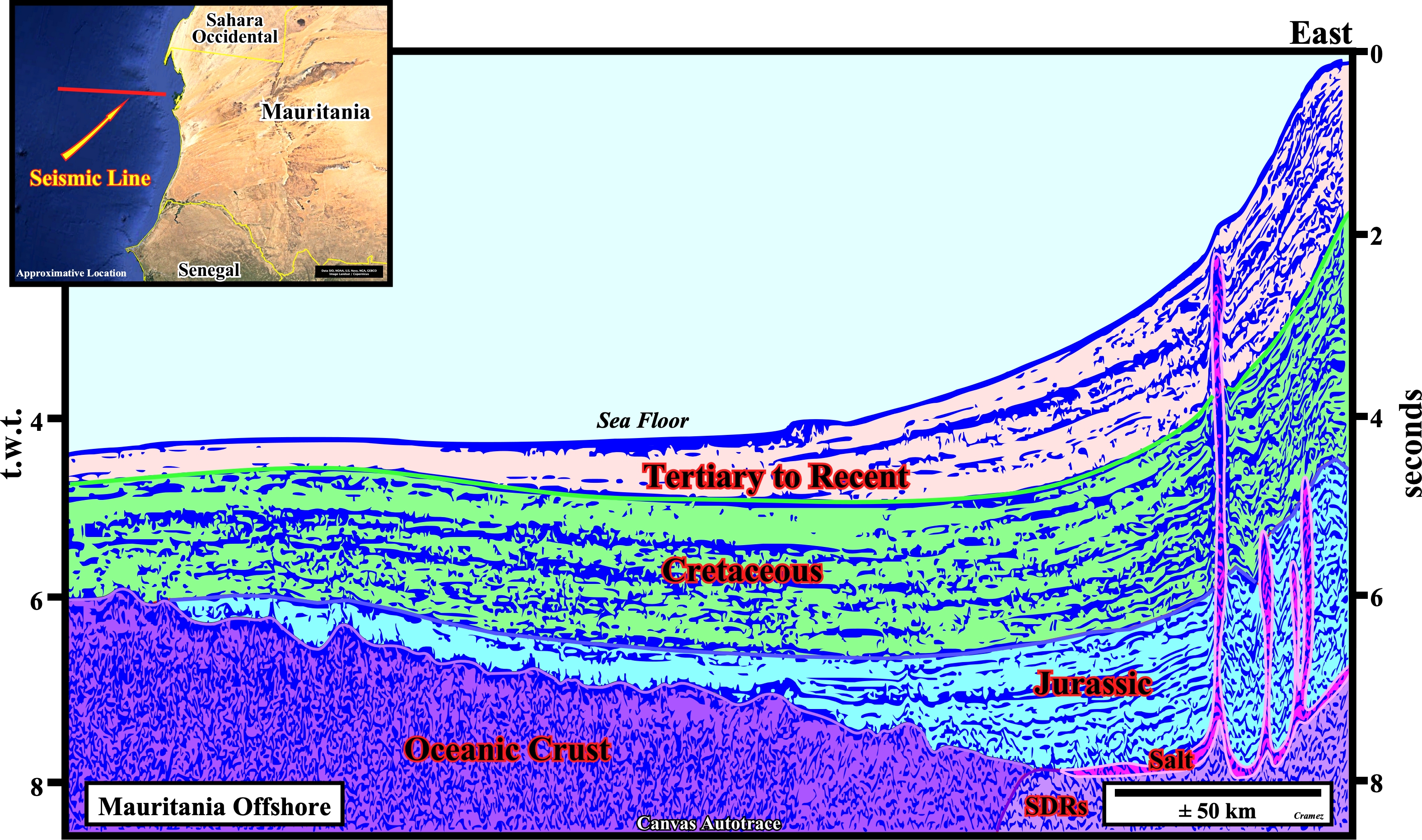
In spite of the fact that this tentative geological interpretation of a regional deep water seismic line of the Mauritania offshore is not calibrated, I guess it is possible to recognize the Triassic salt, over lava-flows (SDRs) and the oceanic crust. The salt is identified by its diapiric structures, which are, probably, individualized by vertical salt welds, in other words their thickness is highly exaggerated for convenience of interpretation (salt domes with vertical walls, as depicted above are a physical impossibility, since the density of the salt do not phase in depth, i.e., the salt is not compactable). The salt layer is, hypothetically, deposited above sub-aerial lava flows, which change laterally to oceanic crust characterized by small topographic anomalies of set of sheeted dykes. The post-salt sediments of the post-Pangea continental encroachment stratigraphic cycle are, clearly, identified. The distal onlaps of the transgressive sediments are, easily, noticeable, particularly of the Jurassic interval. Similarly, the downlaps of the regressive sediments are, obvious, specially those of the Tertiary to Recent package.
Send E-mails to carlos.cramez@bluewin.ch with comments and suggestions to improve this atlas.
Copyright © 2001 CCramez
Last update:
2022