.jpg)
Kenya Offshore
The major structural features of the south Kenya offshore (Lamu offshore geographic basin) are: (i) The Davy-Walu Ridge, which is the north termination of the Davie Fracture Zone and (ii) The Pemba-Simba Ridge southward of Davy-Walu-Ridge, as well as, (iii) The Tembo and Maridadi troughs between these structural highs. An inversion axis (see Page 45) is found between the Davy-Walu Ridge and the Maridadi Trough. These major troughs can be seen to be significant depocenters in the seismic data. The Davy-Walu Ridge is the dominant feature in the data offshore, and this ridge may act as a migration focus for hydrocarbons to migrate up-dip, as may the Pemba-Simba Ridge to the south. The Davy-Walu Ridge terminates in the Walu-Kipini High. Either side of the ridges and troughs are found the Maridadi and Tembo Troughs. These troughs indicate basement lows and thick sedimentary successions, and therefore are likely to represent good hydrocarbon source kitchens. There is also an inversion axis parallel to and just to the south-west of the Davy-Walu Ridge, indicating reactivation of existing faults, and affecting the depth and thermal history of source and reservoir rocks. These faults all follow a regional NW trend discernable on the gravity map, as do the small folds in the area, the Tana and Pate Synclines. Variation in the gravity to the north of the Davy-Walu Ridge may suggest the limits of the diapiric province that is believed to exist in the area, while a basement high approximately 150 km in diameter may indicate a large anticline structure in the region, as is observed on the seismic (O. Osicki et al., 2015).


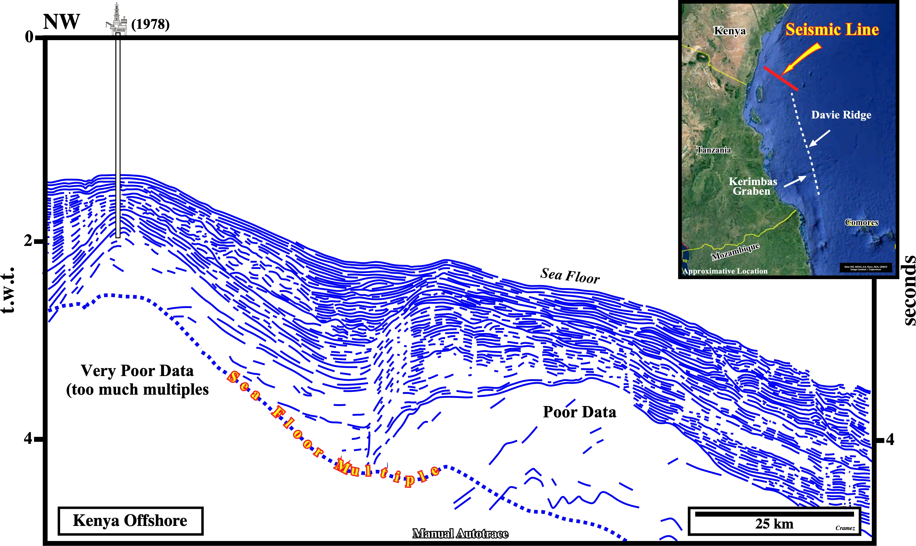
On this manual autotrace, the breakup unconformity, as well as, the rift-type basins which predate the breakdown of the Gondwana lengthened continental crust are, easily, recognized in spite of the fact that few rifting normal faults were reactivated, recently ,forming the well known Kerimbas graben, which has nothing to see with the Lacerda Graben of the Northern Mozambique as elucidated on next tentative interpretation.


On this manual autotrace of a seismic line of the northern Mozambique offshore, in spite of the fact that the Lacerda Graben is bounded by the Davie Ridge, it cannot be correlated with the Kerimbas Graben of the Tanzania offshore, since normal fault bordering the Lacerda graben is prolonged to the onshore as depicted on the location map. The rift-type basin predating the breakdown of the Gondwana continental crust belong to the lengthened Gondwana continental crust and not to the Atlantic-type divergent margin.


The major structural features of the south Kenya offshore (Lamu offshore geographic basin) are: (i) The Davy-Walu Ridge, which seems to be the north termination of the Davie Fracture Zone, (ii) The Pemba-Simba Ridge, southward of Daschle-Walu-Ridge and (iii) The Tembo and Maridadi troughs between the structural highs, which strongly suggest, as illustrated above, basement lows and thick sedimentary packages. An inversion axis is found between the Davy-Walu Ridge and the Maridadi Trough. Such tectonic inversion (see also Page 45) suggests the reactivation of preexisting faults, probably associated with the lengthening of the Gondwana lithosphere predating the breakup unconformity, which is difficult to recognize on this autotrace. Nevertheless, on this tentative interpretation, it is placed at the bottom of the Cretaceous.
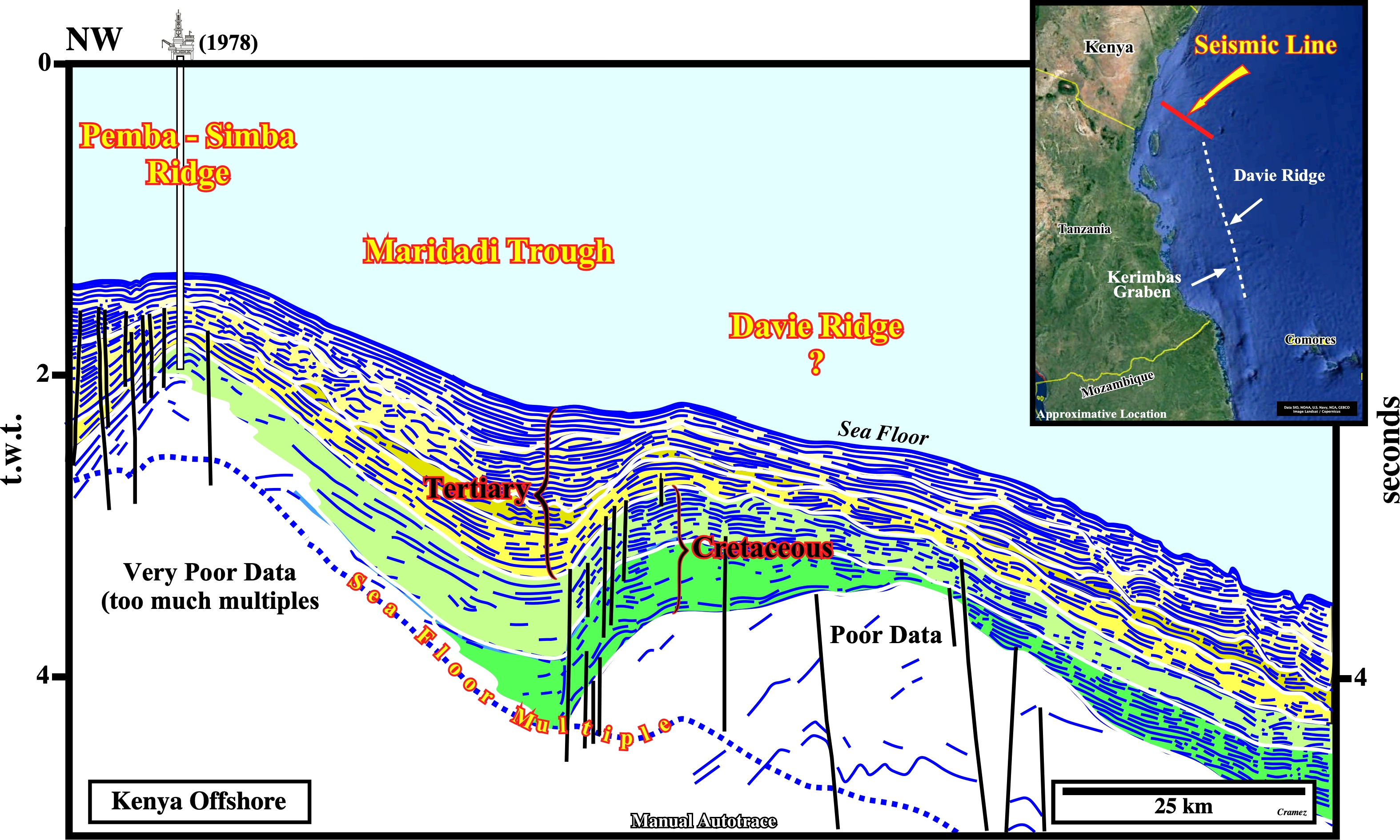
This tentative geological interpretation of a manual autotrace of an old seismic line of the Kenya offshore, illustrates the eastern flank of the Pemba-Simba structural high. This structural high was drilled, in 1978, by CFP (original name of TotalEnergies) and gas shows were founded in the Upper Cretaceous sediments. The Maridadi Trough and the Davie Ridge (?) are also recognized without difficulty. At the stratigraphic and basin context point of view, this kind of data (old unmigrated seismic lines) do not give significant informations. They exhibited too much multiples and diffractions.

![]()
![]()
Send E-mails to carlos.cramez@bluewin.ch with comments and suggestions to improve this atlas.
Copyright © 2001 CCramez
Last update:
2022
![]()