.jpg)
Libya Offshore
Gulf of Syrte
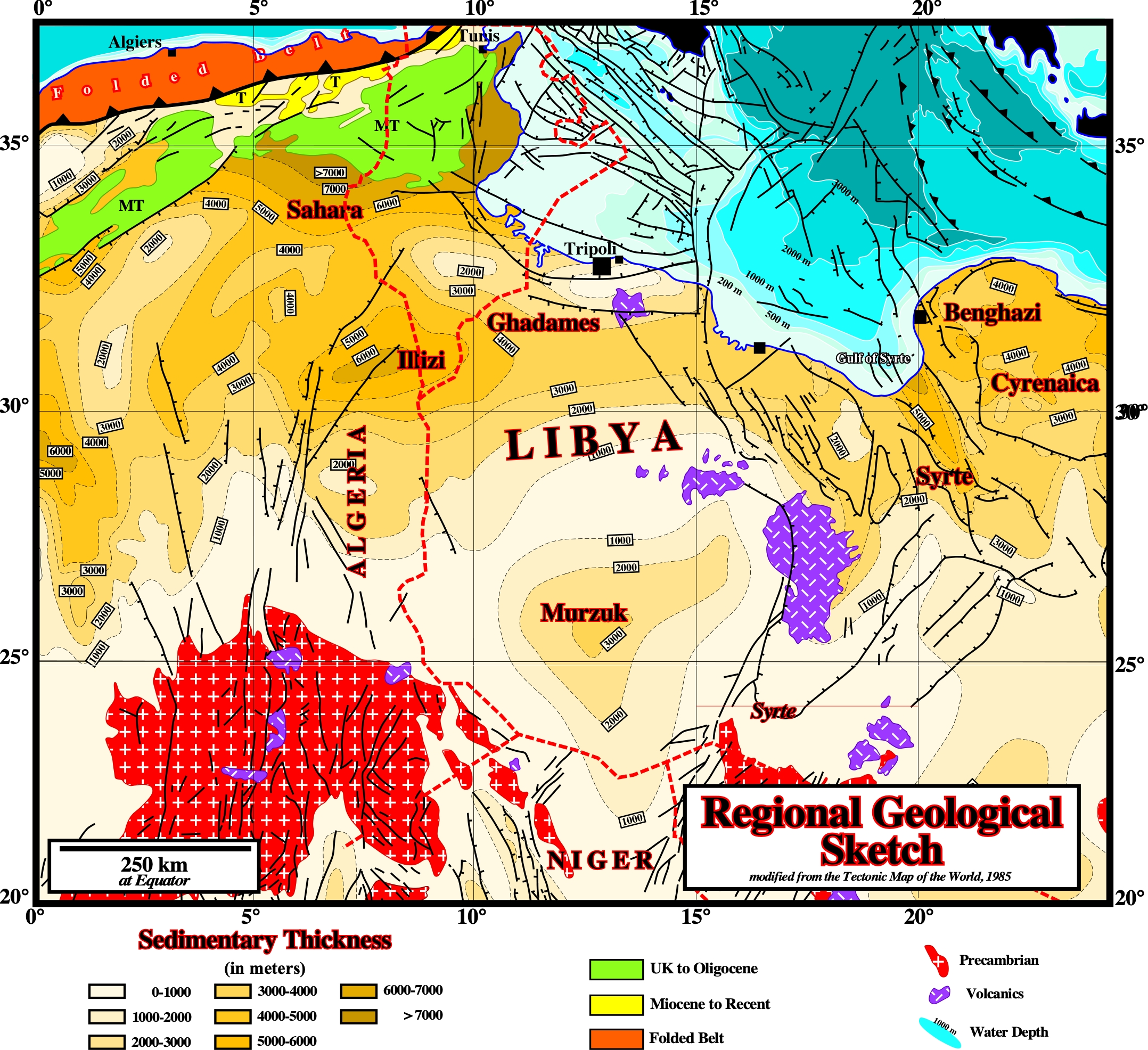
On this regional geological map we can see the main geological features characterizing the Syrte embayment (onshore) and the Marmarica / Djefara geographic basin (onshore). The Syrte embayment or Syrte geographic basin, is the youngest of the Libyan geographic basins (Murzuk, Ghadames, Al Kufra and Cyrenaica). It has the largest petroleum reserves in Libya and is ranked 13th among the world's petroleum sedimentary basins. Geologically speaking, certain geoscientist consider that the area was a permanent high from the Middle Paleozoic until the Early Mesozoic and they attribute its origin the collapse of the Syrte Arch during latest Jurassic to Early Cretaceous times. In the Bally's basin classification it corresponds to an Atlantic-type divergent margin. The Marmarica / Djefara geographic basin covers almost Libyan offshore, between Tunisia/Malta/Ragusa platform and Cyrenaica geographic basin. The Libya offshore seismic lines suggest two phase of rifting. The half-graben and graben of the first phase were filled, mainly, by non-marine Jurassic– Early Cretaceous sediments, in which organic rich lacustrine sediments can form a significant generating petroleum subsystem. The second phase, which is less evident than the first one, since there is a change in the orientation of the σ2 of the extensional tectonic regime responsible of the lengthening, occurred during the Mid-Late Cretaceous. During this phase there are development of troughs and platforms. A marine ingression, progressively, filled the lower areas with clastic sediments, which are fossilized by evaporites and and shallow-marine carbonates. The Atlantic-type divergent margin seems to be initiated by the Maastrichtian marine ingression, since marine sediments covered not only the infilled troughs, but the rifted platforms as well (rift-type basins). At the end of the Miocene, during the Messinian a thick salt interval was deposited following a drying-up of the Mediterranean Sea between 5.96 and 5.33 Ma. The dessication of the Mediterranean Sea ended with the reopening of the Strait of Gibraltar (Zanclean marine ingression). It is interesting to notice that only the inflow of Atlantic water maintains the present Mediterranean level. In fact, without the Atlantic water's inflow, with a rate of net evaporative loss of ± 3,3 km3/y, the Mediterranean Sea, with its 3.7 Mkm3 of water, would dry up ± 1000 years. However, this geological events can just be recognized on autotraces of modern seismic lines, using hypothetical deductive interpretation approches and not on the majority of the old unmigrated seismic lines as illustrated below
On this regional geological map we can see the main geological features characterizing the Syrte embayment (onshore) and the Marmarica / Djefara geographic basin (onshore). The Syrte embayment or Syrte geographic basin, is the youngest of the Libyan geographic basins (Murzuk, Ghadames, Al Kufra and Cyrenaica). It has the largest petroleum reserves in Libya and is ranked 13th among the world's petroleum sedimentary basins. Geologically speaking, certain geoscientist consider that the area was a permanent high from the Middle Paleozoic until the Early Mesozoic and they attribute its origin the collapse of the Syrte Arch during latest Jurassic to Early Cretaceous times. In the Bally's basin classification it corresponds to an Atlantic-type divergent margin. The Marmarica / Djefara geographic basin covers almost Libyan offshore, between Tunisia/Malta/Ragusa platform and Cyrenaica geographic basin. The Libya offshore seismic lines suggest two phase of rifting. The half-graben and graben of the first phase were filled, mainly, by non-marine Jurassic– Early Cretaceous sediments, in which organic rich lacustrine sediments can form a significant generating petroleum sub-system. The second phase, which is less evident than the first one, since there is a change in the orientation of the σ2 of the extensional tectonic tectonic responsible of the lengthening, occurred during the Mid-Late Cretaceous, occurred during the Late Cretaceous. During this phase there are development of troughs and platforms. A marine ingression, progressively filled the lower areas with clastic sediments, which are fossilized by evaporites and and shallow-marine carbonates. The Atlantic-type margin seems to be initiated by the Maastrichtian marine ingression. Marine sediments covered not only the infilled troughs, but the rifted platforms as well (rift-type basins). At the end of the Miocene, during the Messinian a thick salt interval was deposited following a drying-up of the Mediterranean Sea between 5.96 and 5.33 Ma. The dessication of the Mediterranean Sea ended with the reopening of the Strait of Gibraltar (Zanclean marine ingression). It is interesting to notice that only the inflow of Atlantic water maintains the present Mediterranean level. In fact, without the Atlantic water's inflow, with a rate of net evaporative loss of ± 3,3 km 3/y, the Mediterranean Sea, with its 3.7 Mkm3 of water, would dry up ± 1000 years. This geological events can just be recognized on autotraces of modern seismic lines, using hypothetical deductive interpretation approches and not on the majority of the old unmigrated seismic lines as illustrated below.
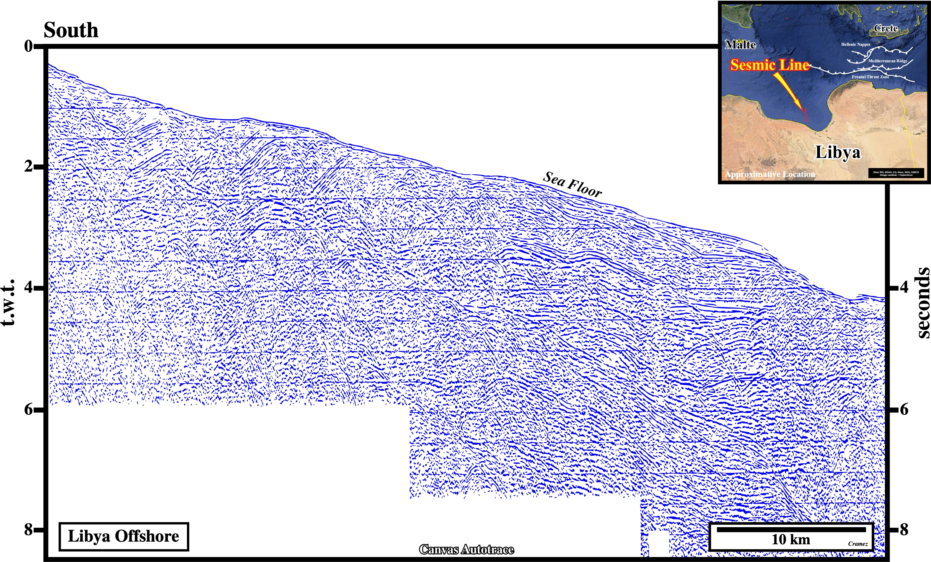
This Canvas autotrace of an old unmigrated seismic line of the Libya offshore illustrates the fact that, in certain kind of data, even knowing the regional and global context of the area, that is to say, knowing what you should look for on the data (basement, pre-rifting sediments, rift-type basins, breakup unconformity, Atlantic-type divergent margin, etc.) it is impossible to propose a tentative geological interpretation (compare it with modern data of the same area, Page 46A). This kind of data was the only available when I was a young exploration, i.e., before the advent of migration. In addition, at that time, the majority of geoscientist in charge of the geological interpretation of the seismic line used a naive inductive approach ignoring the hypothetical deductive approach proposed by K. Popper (1934). Indeed, K. Popper not only proposed falsification as the demarcation line between science and pseudo-science, but also pointed out that a geoscientist can just recognize on a seismic line what he knows and what he is expecting to see ("Theory precedes Observation"). In fact all tentative geological interpretation of a seismic line is theory laden as corroborated on Page 46.
![]()
![]()
Send E-mails to carlos.cramez@bluewin.ch with comments and suggestions to improve this atlas.
Copyright © 2001 CCramez
Last update:
2022
![]()