.jpg)
Guinea-Bissau
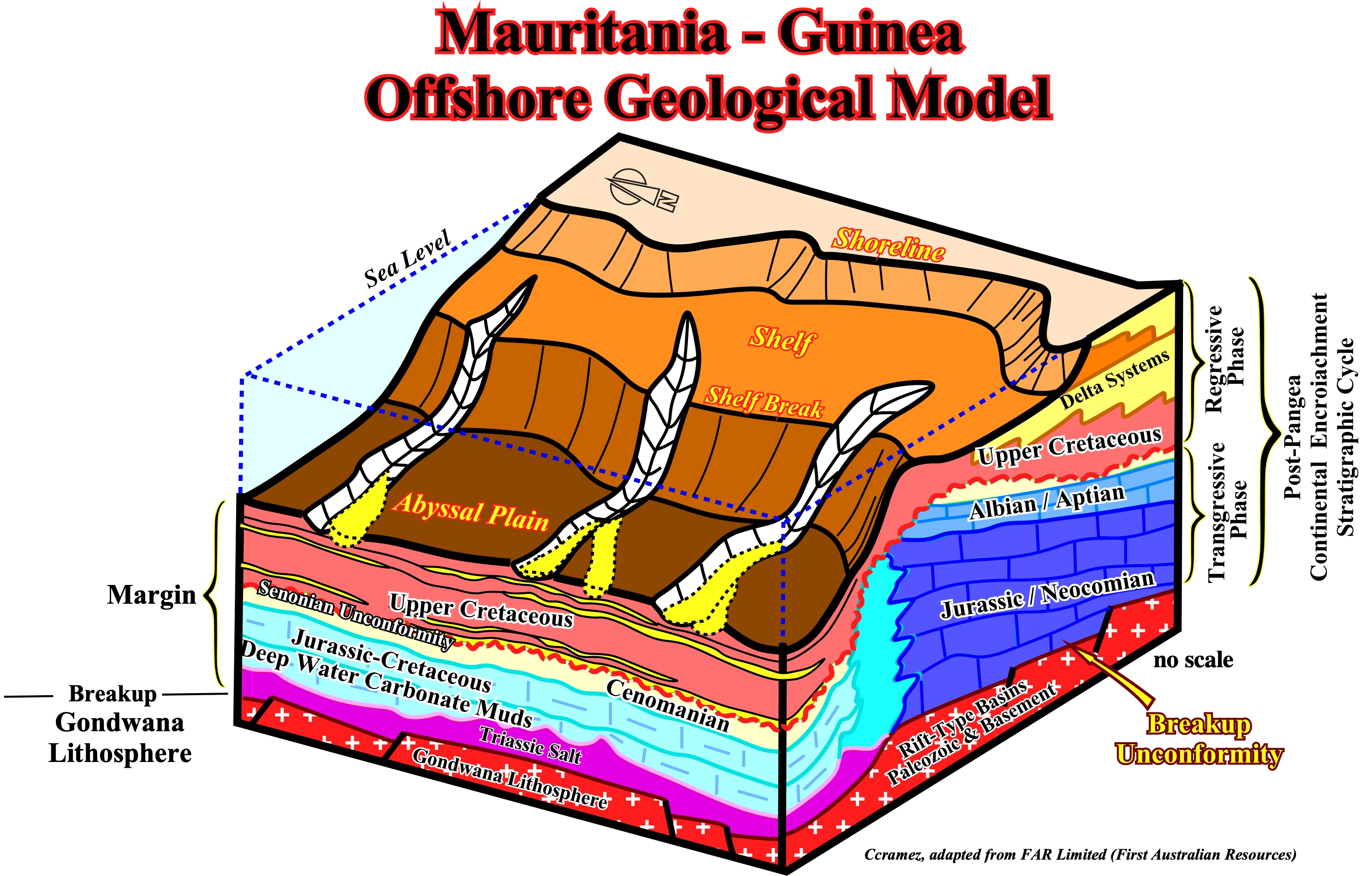
This block diagram illustrates the geological configuration of the post Pangea continental encroachment stratigraphic cycle in the Mauritania-Guinea offshore. Above the breakup unconformity, which is the upper boundary of the pre-rifting and rift-type basin rocks, a Triassic salt layer was deposited in a confined shallow water depocenter, apparently, from potash enriched brines due to the spilitization of sub-aerial volcanism (lava-flows, i.e., SDRs). Then, due to absolute sea level rise induced by the volume reduction of the oceanic basins created by the emplacement of the oceanic ridge, carbonate sediments of the transgressive retrogradational phase were deposited. During this stratigraphic phase, the shoreline was, progressively, displaced landward, while the successive shelf breaks were, more or less, stacked in a still-stand position (strong upbuilding) creating an abrupt deep water geological setting, i.e., an abrupt change between the shelf and the abyssal plain environments with a quite steep continental slope. Since the absolute sea level started to fall, due to the volume reduction of the oceanic basins induced by the subduction of the oceanic crust along the subduction zones and the continental collision, i.e., during the regressive phase of the post-Pangea continental encroachment stratigraphic cycle, submarine basin and slope fans deposited in the deeper parts of the basin. Potential turbidite depositional systems may form excellent entrapment-migration petroleum sub-systems, which can be feed by potential deep-water source rocks intervals.
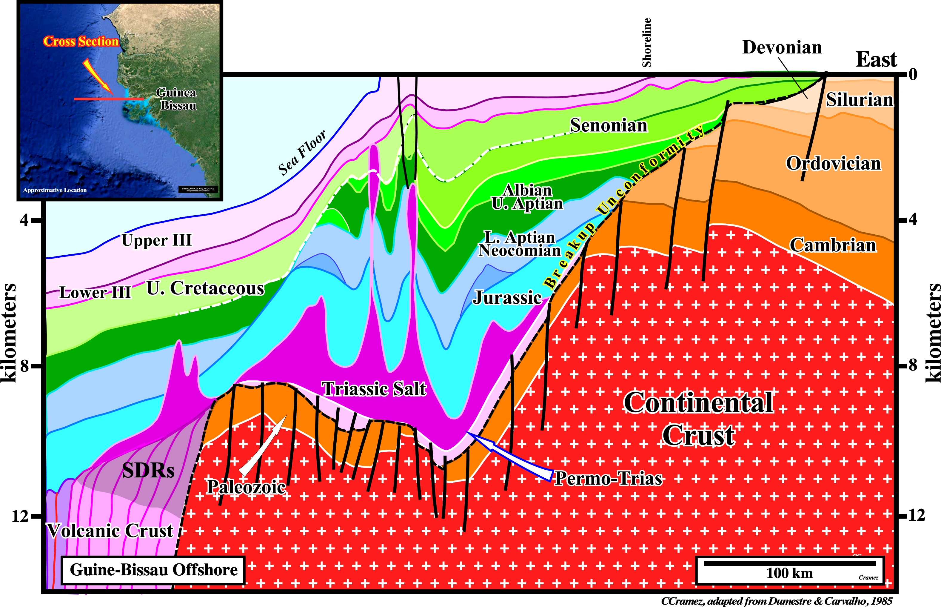
The geology of Guinea-Bissau (onshore and offshore) is illustrated on this geological cross-section, which is based on a composite seismic profile. The Gondwana is here represented by a Precambrian basement (continental crust) and Paleozoic sediments, which form the infrastructure of the Ceno-Mesozoic Atlantic-type divergent margin and associated underlying rift-type basins. Immediately after the break of the lithosphere, took place a sub-aerial volcanic accretion, by deposition of lava-flows (SDRs), over which the basal sediments of the margin were deposited, particularly, the Triassic salt layer, which brine was enriched in potash by spilitisation (mineral transformation and liberation by metasomatism induced by hydrothermal circulation) of the underlying volcanic material. Above the salt, was deposited the transgressive retrogradational (backstepping geometry) stratigraphic phase of the post-Gondwana continental encroachment cycle, over which was deposited the regressive progradational stratigraphic phase of the same encroachment cycle. During the transgressive stratigraphic phase, the basin, seismically speaking, has a platform (shelf break was located far away and seaward of the shoreline). On the contrary, during the regressive phase, the basin has no shelf (continental breaks and shorelines were, more or less, coincident). The limit between these two stratigraphic phases is the major Upper Cretaceous downlap surface, which, here, seem to have a Senonian age. Theoretically speaking, turbidite deposits are, likely, in Mesozoic (highstand geological condition), seaward of the retrogradational shelf breaks, in association with slope and shelf instabilities and failures induced, mainly, by salt tectonics, and in Tertiary (lowstand geological condition) in association with relative sea levels falls. This regional cross-section assume the presence of SDRs between the oceanic crust (sheeted dykes) and the Gondwana small supercontinent (southern continent of the Pangea supercontinent).
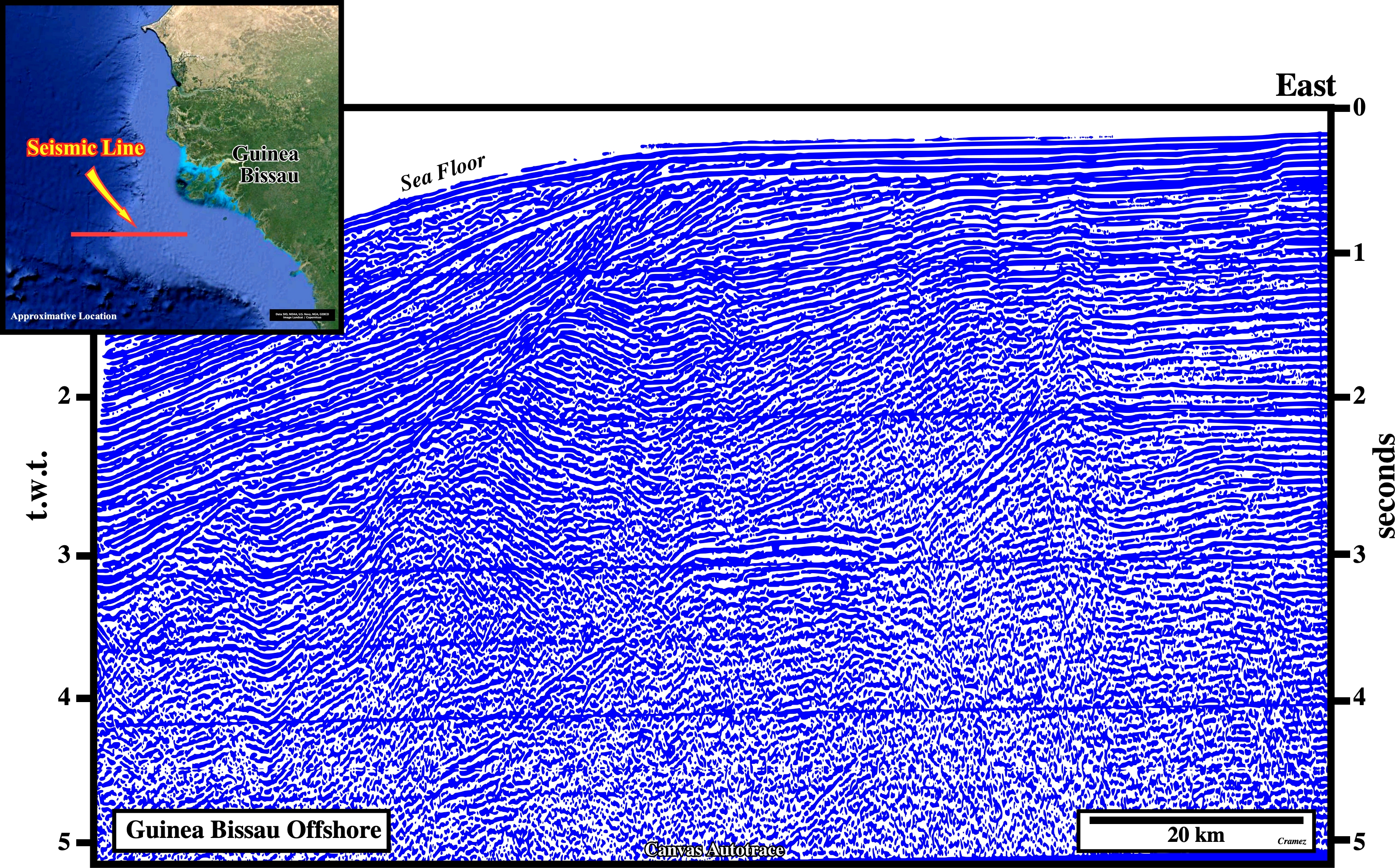
On this geological tentative interpretation of a regional seismic line of the Guinea-Bissau offshore, the more likely locations of turbidites deposits are : (i) Seaward of the last Jurassic shelf break, which is underlined by a reefal construction (such a turbidite deposits have probably a limestone facies) ; (ii) Seaward of the Cretaceous slope and shelf failures, which are highlighted by curvilinear normal faults and, in the Tertiary (iii) In association with the significant relative sea level falls that put the sea level below the basin edge (lowstand geological conditions), as well as, at the bottom of the progradation of the lowstand prograding wedge (shingled turbidites) induced by turbidite currents triggered by upper slope and shelf break instabilities and flush floods.
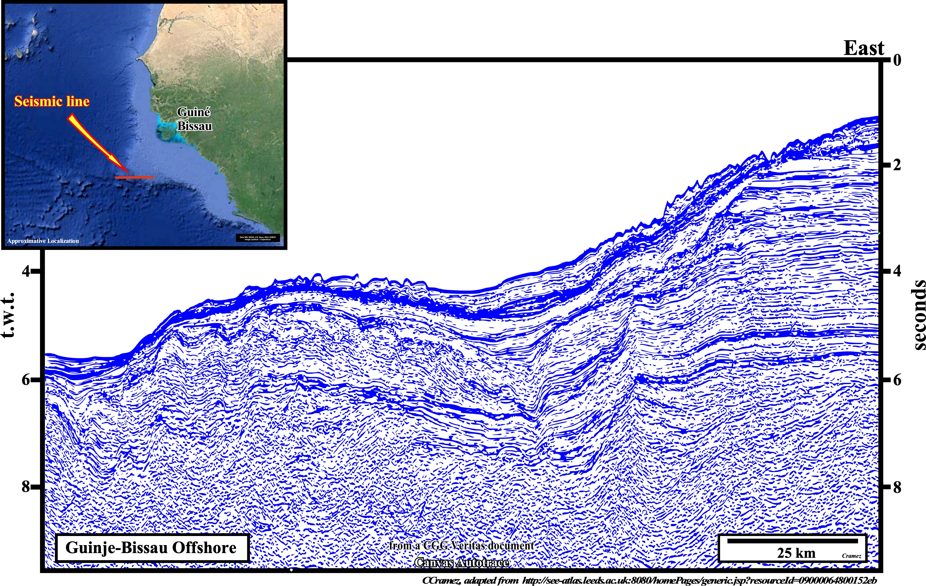
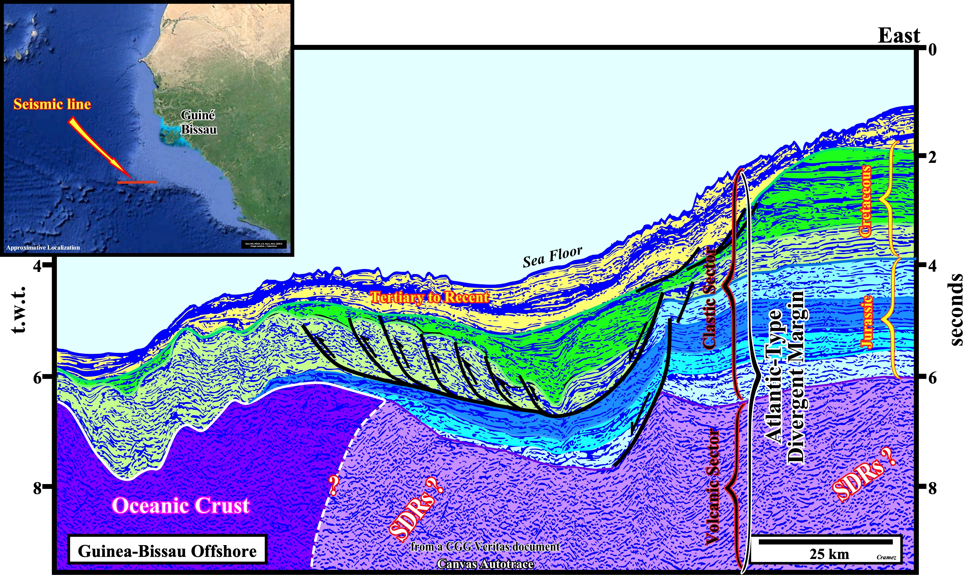
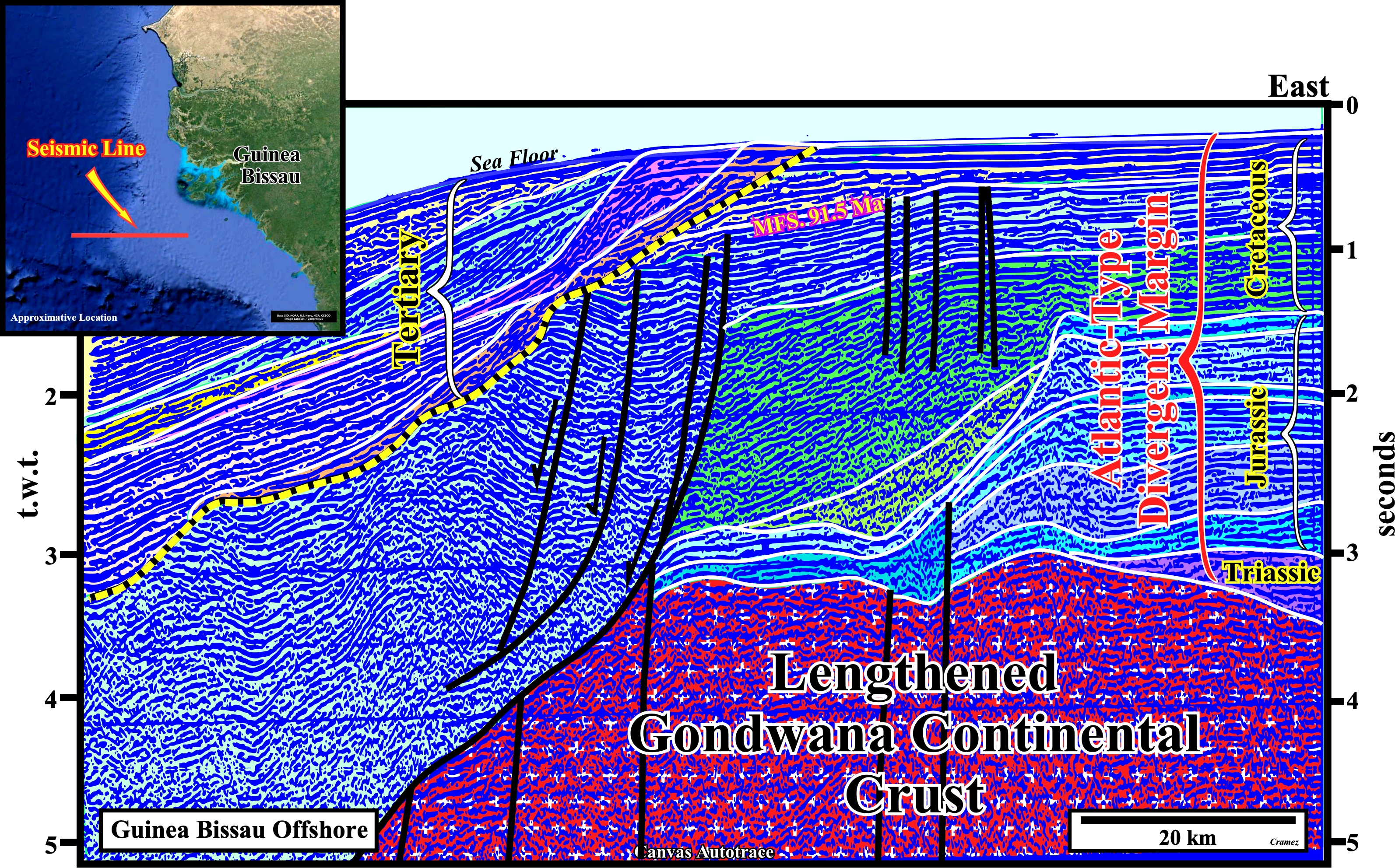
On this tentative geological interpretation of a Guinea-Bissau seismic line, ending not far from Capo Verde, the SDRs, that is to say, the post-breakup lava-flows (sub-aerial volcanic crust) seem to be present in the central and eastern part of the Canvas autotrace. Indeed, the seismic reflectors not only dip seaward but they exhibit a divergent configuration as (the thickness between two successive reflectors increases toward the expansion centers). However the limit between the SDRs and the oceanic crust (generally, sheeted dykes) is hypothetical. Above the volcanic crust (sub-aerial and oceanic) the transgressive phase of the post-Pangea continental encroachment stratigraphic cycle is, easily, recognized. Similarly, the passage platform-slope in the transgressive sediments is not difficult to map, particularly, because in the Cretaceous sediments it is enhanced by a typical listric fault, i.e., a fault, which at the top, is normal and reverse at the bottom (as the movement of a spoon). Notice that, as, depicted in the location map, the fault plane of a listric fault is curved, reason why many geoscientists, erroneously, call all faults with curved plane listric faults. All listric faults have a curved plane, but not all faults with a curved fault plane are listric (listric comes from the Greek "listron" that means "spoon"). The regressive phase of the post-Pangea continental encroachment cycle is quite thin and represented, mainly, by Tertiary to Recent sediments. The Cretaceous regressive sediments (post-Turonian) are difficult to recognize.
![]()
![]()
Send E-mails to carlos.cramez@bluewin.ch with comments and suggestions to improve this atlas.
Copyright © 2001 CCramez
Last update:
2022
![]()