.jpg)
Angola Offshore

On this idealized geological cross-section of Angola offshore, the major geological event of the area, i.e., the breakup of the Gondwana lithosphere is, clearly, recognized by the breakup unconformity, which ends the lengthening of the Gondwana. During the lengthening half-grabens are formed and filled by non-marine sediments, mainly, organic rich lacustrine sediments (when the size of the half-graben is appropriated to avoid a lateral infilling) forming what we call rift-type basins. Locally, above the half-graben infillings, depocenters (sag basins) can develop before the breakup of the lithosphere. After the breakup of the Gondwana the margins (Africa and South America) are accreted, initially, by lavas-flows (SDRs not represented in the cross-section) over which shallow-water Lower Cretaceous sediments are deposited, particularly, evaporites. As soon as the expansion centers become submarine, the lava-flows are replaced by oceanic crust and sedimentation becomes, more and more, marine due to associated absolute sea level rise (Cretaceous marine ingression). During the Atlantic-type divergent margin , globally, the predominant tectonic regime is extensional (lengthening) characterized by an gravitational salt tectonics and halokinesis in the continental slope and conventional offshore. Such an extensional tectonic regime creates, in the deep parts of the basin, a volume problem, particularly near the western limit of the salt basin, where the salt cover and overburden are strongly shortened and thickened by thrusting and folding exceeding the limit of the basin by a well recognized salt nappe.

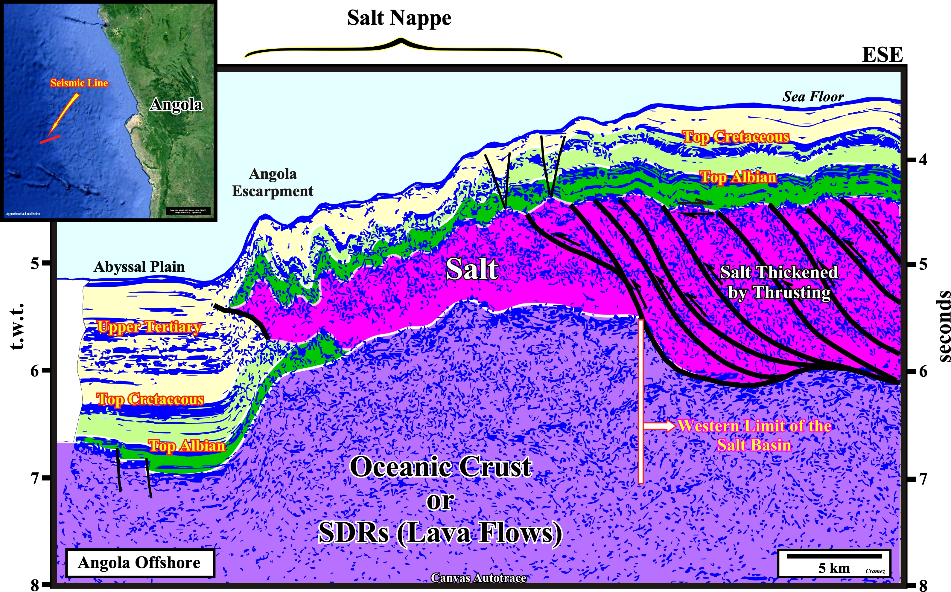
The Angola Escarpment marks the seaward limit of the salt tectonics and can be traced from Benguela geographic basin to the Douala geographic. basin. The major ramp in the base of the salt seems to underline the western limit of the original salt basin. A simple mental depth conversion of this tentative interpretation is still more convincing. The salt thins from approximately 3500 meters in the plateau (continentward) to approximately 1750 meters in the salt nappe. The salt nappe contains oblique internal reflector suggesting an internal of internal thrusting but these are less common than in the ticker salt plateau. Obviously, the salt was thickened by thrusting to counterbalance the up-dip salt extension in continental slope and conventional offshore. Such high thickness is not due to a maximum of subsidence, as few geoscientists assume to justify a breakup of the Gondwana small supercontinent postdating the salt deposition. Seaward of the salt nappe, the seismic record is clear because salt is absent. It is important to notice not only the normal Cretaceous stratigraphic interval above above the salt nappe but above the salt thickened interval (by thrusting) as well.
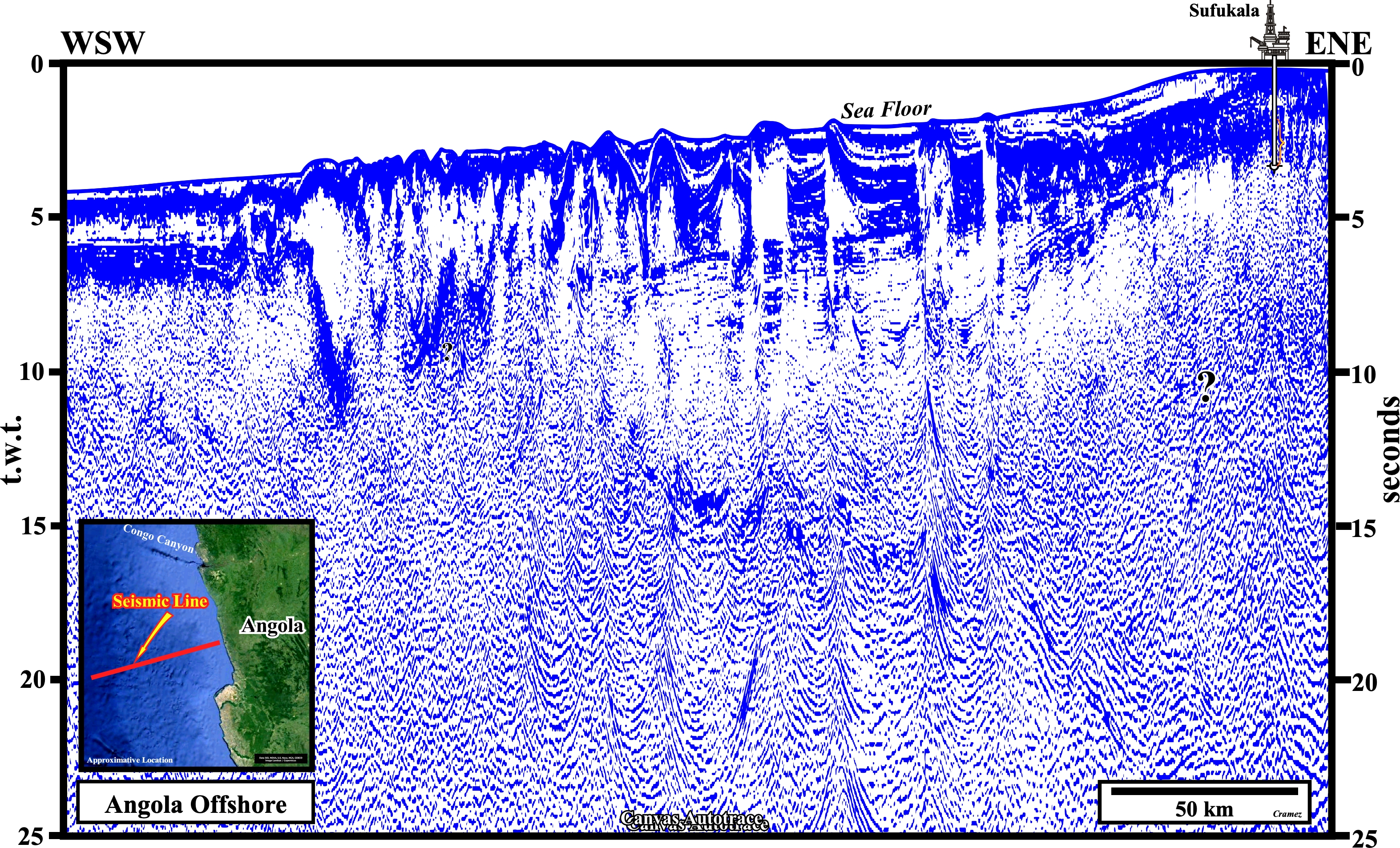
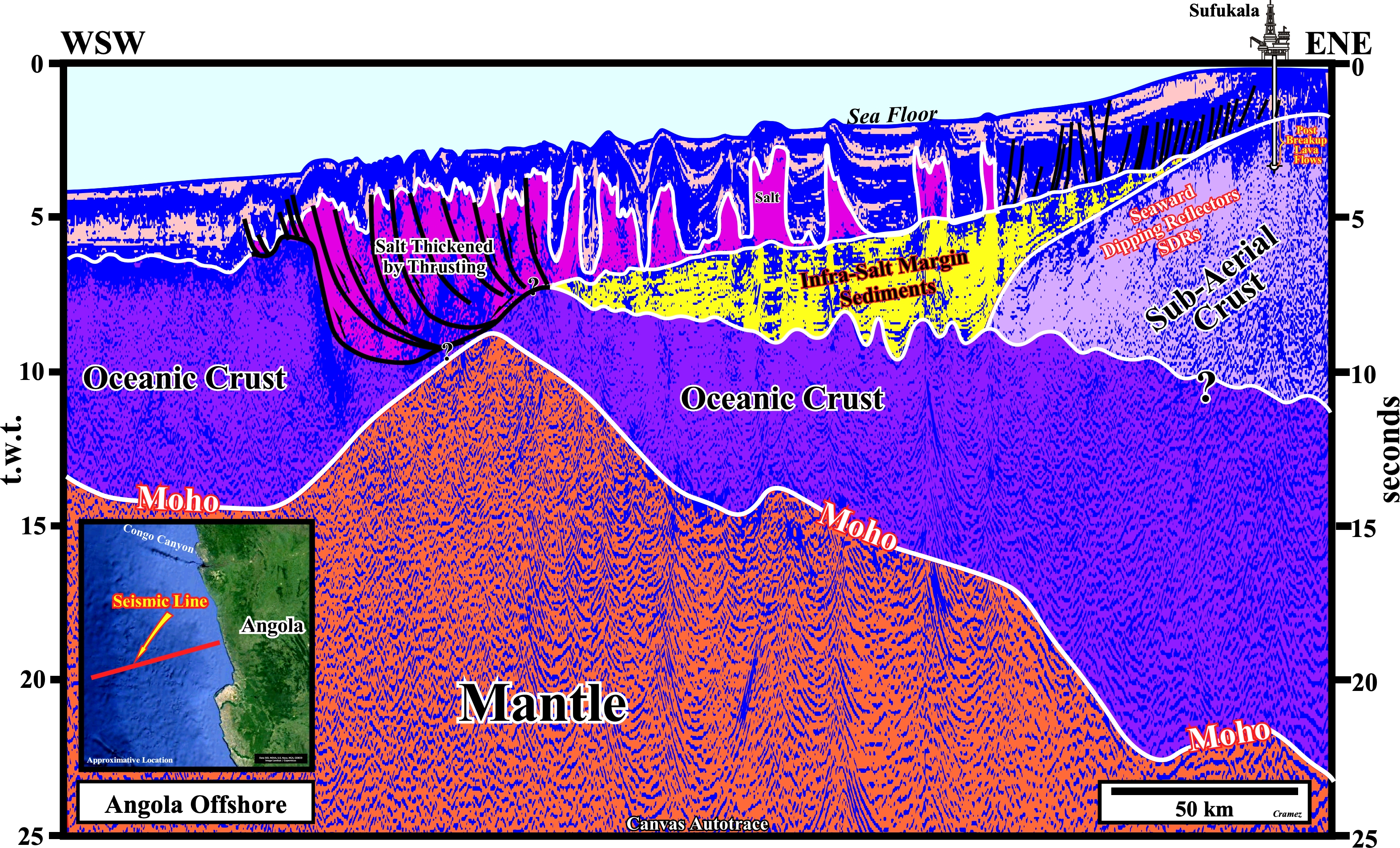
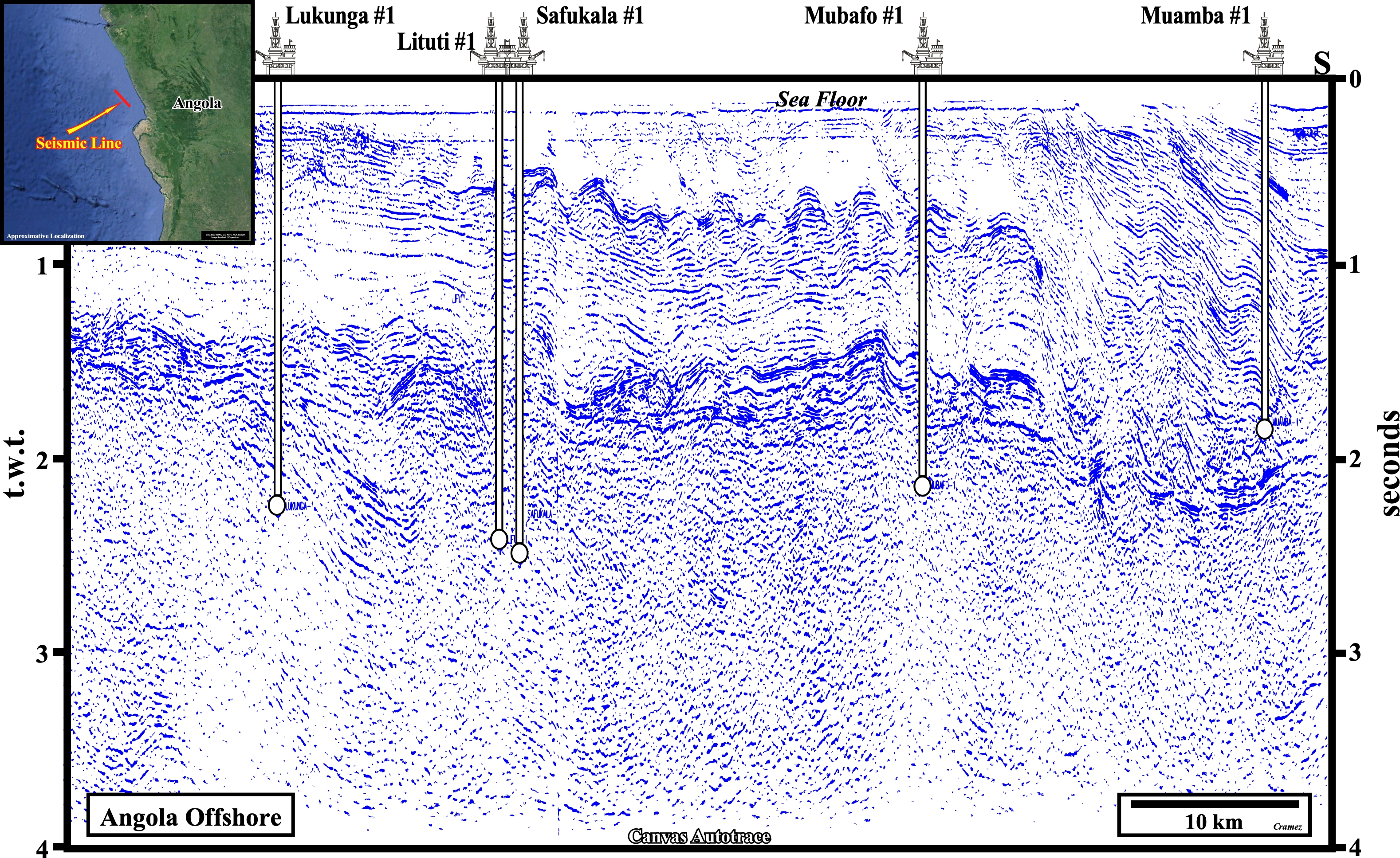
This Canvas autotrace of depth version of a GXT seismic line shot in offshore Angola, located between the hydrocarbon rich Congo geographic basin and poor Kwanza geographic basin, i.e., along the Ambriz structural high is, partially, calibrated by the results of the exploration wells drilled in blocks 5 and 6 of the Angola Offshore (see below), which indicate a substratum formed by post-breakup lava flows (SDRs acronym of Seaward Dipping Reflectors).Three features on this autotrace seismic are quite important. The first one concerns the geological model (interval velocities) used in the time-depth conversion: how can we get, in a depth seismic section, salt diapirs with vertical walls, knowing the density of the salt (2.15-2.17) does not change in depth, (the density of others rocks increase). An high salt diapir with vertical walls is a physical impossibility. As the density of the salt is roughly constant, in depth, there is always a density inversion point with the surrounding sediments. Above the inversion point, the pressure of the salt against the sediments is not compensated by the pressure of the sediments against the salt. Consequently, the salt flows laterally and vertically above the inversion point. Below the density inversion point is the contrary: the pressure of the sediments against the salt is not compensated by the pressure of the salt against the sediments, and the salt is squeezed upward. The second important feature is presence of the seaward dipping reflectors (found in Safukala ≠1; Lifuti ≠1, Mubafo ≠1 exploration wells illustrated in next plates) below the under seismic resolution of the infra-salt margin sediments, i.e., seismically speaking below salt induced tectonic disharmony (interface between the deformed cover-overburden and the undeformed infra-salt rocks). Thirdly and perhaps most important for the hydrocarbon exploration is the presence, westward of the Safulaka 1, in particular, below tectonic disharmony of a depocenter of infra-salt margin sediments (colored in yellow), which is, often erroneously interpreted, in my opinion, as rift-type basin sediments.
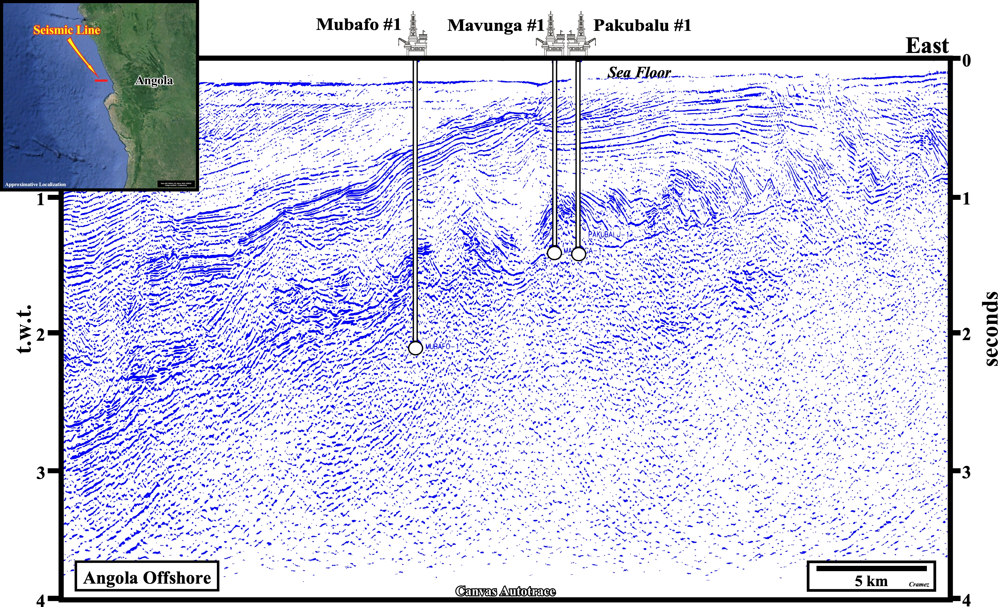
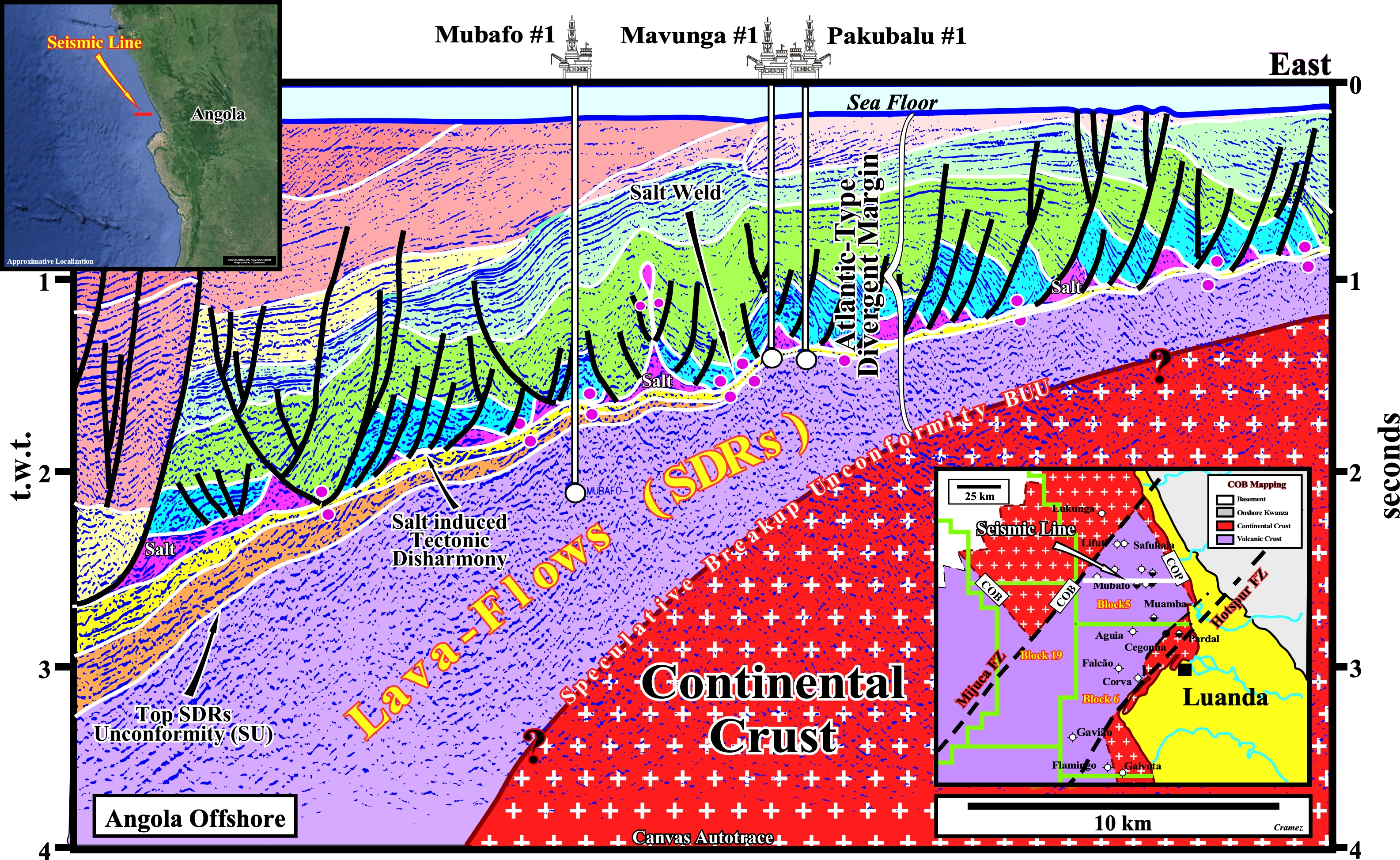
On this tentative geological interpretation of a Canvas autotrace of an Angola offshore seismic line along which the exploration wells Mubafo ≠1, Mavunga ≠1 and Pakubalu ≠1 were drilled, we can recognize: (i) The seaward dipping and thickening reflectors (post-breakup lava-flows) deposited since the breakup of the Gondwana took place ; (ii) An speculative breakup unconformity (BUU), i.e., a speculative limit between the lengthened Gondwana continental crust and the lava-flows (SDRs) of the base of the divergent margin ; (iii) The margin infra-salt sediments, which strongly thick westward ; (iv) Below the sandstone Cuvo sediments (in yellow on the tentative interpretation) an organic rich shale interval (in brown), probably, lacustrine shales, deposited, directly, over the sub-aerial volcanism (SDRs). In the lower rigth corner of this figure, is depicted the COB (Continent Oceanic Boundary) mapping of the area, which is seems to be controlled by The Mijuca and Hotspur fracture zones. In fact, the substratum of Ambriz and Quenquela geological provinces is sialic, while that of the Cegonha geological province, between the Mijuca and Hotspur fractures zones, is mafic, as illustrated in the next figure.
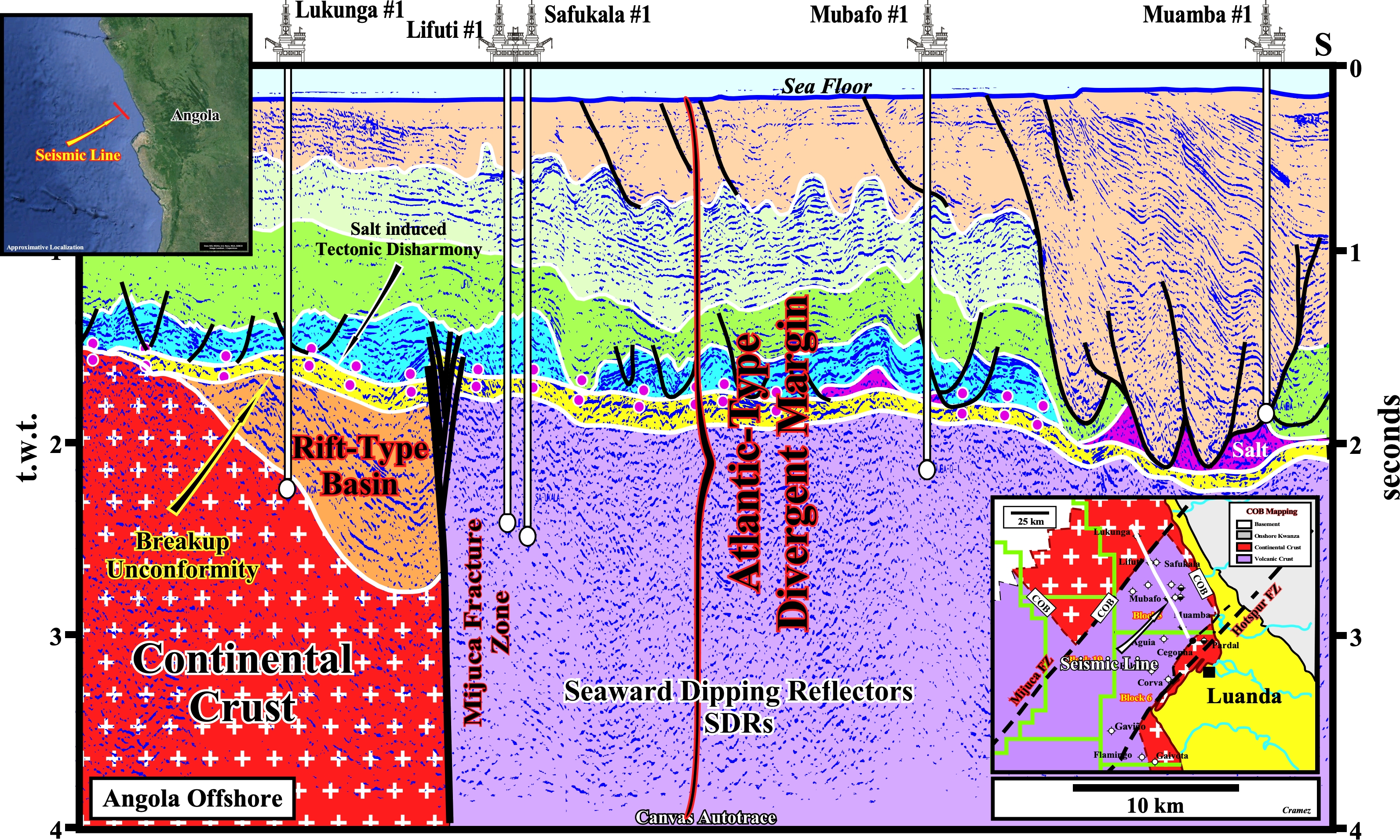
On this tentative geological interpretation of a Canvas autotrace perpendicular to that of the previous figure, we can say: (i) The salt induced tectonic disharmony (bottom of the salt layer and salt welds) is evident, since the overlying sediments (cover + overburden) are deformed (lengthened), while the underlying are undeformed ; (ii) Northward of the Mijuca fracture zone, the breakup unconformity (BUU) corresponds to the bottom of the margin infra-salt sediments (in yellow), which fossilize the basement and/or rift-type basins sediments ; (iii) Southward of the Mijuca fracture zone, the breakup unconformity is difficult to recognize, since it is below sub-aerial volcanism (lava-flows). The limit between continental and volcanic crust (COB) corresponds, here, to the Mijuca fracture zone. In fact, Likunga ≠1 recognized rift-type basin sediments and the basement, i.e., the breakup and pre-rifting unconformity, while Lifuti ≠1, Safukala ≠1 and Mubafo ≠1, recognized significant thickness of sub-aerial volcanism below the infra-salt margin sediments (Cuvo formation = Chela formation) without reach the breakup unconformity.

![]()
![]()
Send E-mails to carlos.cramez@bluewin.ch with comments and suggestions to improve this atlas.
Copyright © 2001 CCramez
Last update:
2022
![]()