.jpg)
.jpg)
Angola Offshore
Cabinda Offshore

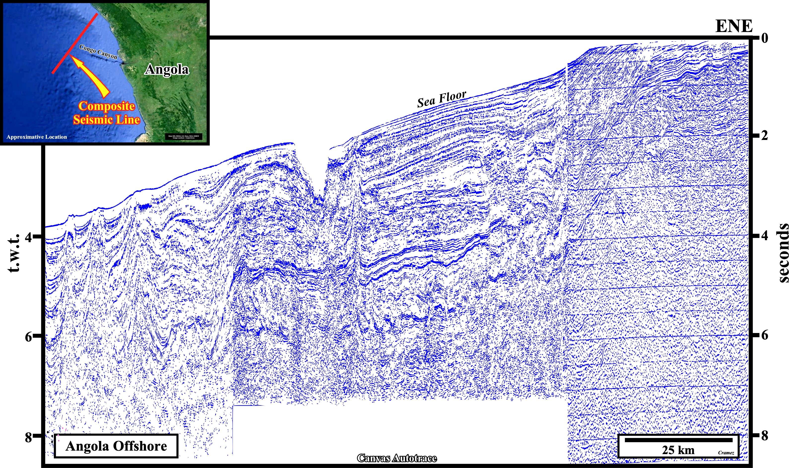
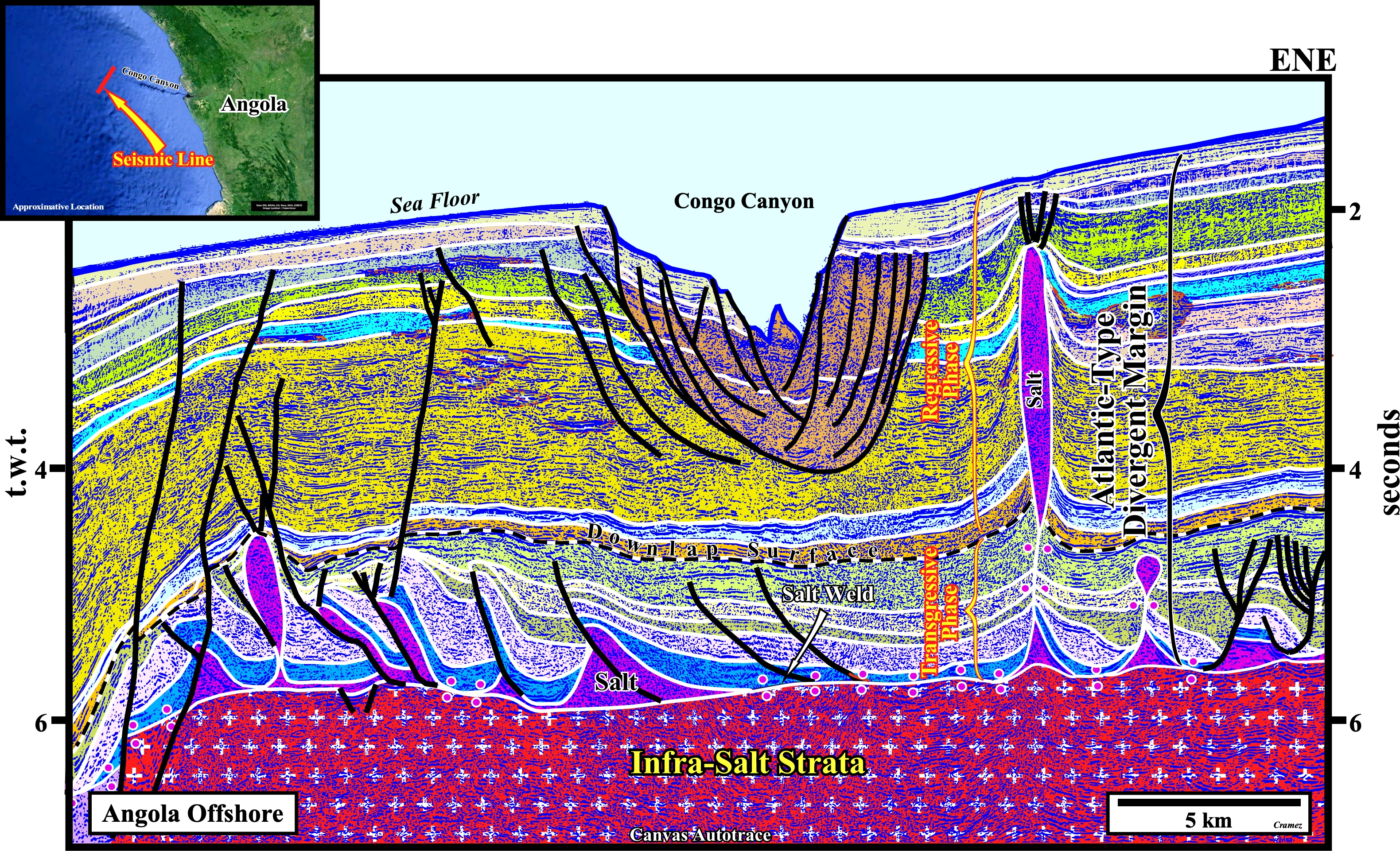
This geological tentative interpretation of a composite seismic line of the Northern Angola Offshore (Congo Geographic Basin) illustrates the geology and potential petroleum systems of the South Atlantic offshores, i.e., of the evaporitic Atlantic-type divergent margins. Above the Gondwana basement, which can be formed by Precambrian granite-gneiss or Paleozoic folded belts (Karoo formation included), from bottom to top one can recognize : (i) Several Lower Cretaceous rift-type basins, developed during the lengthening of the Gondwana lithosphere, i.e., predating the breakup unconformity (BUU) and postdating the pre-rifting unconformity (PRU) and (ii) An Atlantic-type divergent margin deposited after the breakup of the Gondwana lithosphere in association with the oceanization between the two major lithospheric plates individualized (Africa and South America) by the breakup of Gondwana. In this area, the rift-type basins seem to be much more developed and better known, in the conventional offshore and onshore than in deep water. In deepwater, any rift-type basin was recognized by drilling, which is not the case in the conventional offshore and onshore. In the central part of this line, above unconformity (SU, i.e. the unconformity at the top of the sub-aerial volcanism), a thick infra-salt sand-shale interval (in yellow on this tentative), which laterally fossilizes the breakup unconformity and pre-breakup rift-type basins. In the proximal part of the margin (conventional offshore and onshore), the thickness of this infra-salt margin interval is, often, under seismic resolution. Above, the margin infra-salt interval, a more or less, continuous evaporitic interval was deposited. It separates the margin sediments into two realms : (i) The undeformed margin infra-salt sediments and (ii) The deformed supra-salt sediments (salt included). Due to the halokinesis (form of tectonics in which salt flow is powered by buoyancy, i.e., by release of gravity potential energy alone, in absence of significant lateral tectonic forces, σt = 0) and salt tectonics (any tectonic deformation involving salt, or other evaporites, as a mobile layer) created a tectonic disharmony (geological surface individualizing two realms of deformation, often associated with a mobile substratum whether salt or shale) at the bottom of the evaporitic layer (Loeme salt). Above the salt layer, two unequivocal marine sedimentary interval were deposited : (a) The sediments of the transgressive phase of the post-Pangea continental encroachment cycle characterized by a retrogradational geometry, at the bottom, and (b) The sediments of the regressive phase, characterized by a progradational geometry, at the top. Potential source-rocks were possible deposited : (1) In rift-type basins (organic rich lacustrine shales), below the breakup unconformity (BUU) ; (2) In the margin infra-salt sediments (lacustrine / marine source-rocks) ; (3) On the top of the transgressive phase (marine source-rocks) and in the deep water sediments of the regressive phase (organic matter type III, dispersive source-rock). Reservoir rocks are present in the rift-type basins (sandstones and carbonates), margin infra-salt sediments (sandstones and carbonates), supra-salt transgressive sediments (mainly carbonates) and in the sediments of the regressive sedimentary phase (mainly turbidite sandstones). This geological tentative interpretation suggests the occurrence of fracture zones (zones of fragility of the continental crust, which probably favor the breakup of the lithosphere and control the sea floor spreading) and sub-aerial lava flows postdating the breakup unconformity (on lower central and western part of this tentative). Similarly, it brings forward an important Late Tertiary uplift, which, strongly, affects the proximal area of the margin, and that must be taken into account in all geological interpretations and reconstitutions. Finally, do note forget that int depth, i.e., in a time-depth version of this autotrace, the dip of the bottom of the saltis highly exaggerated by the westward increasing water depth.


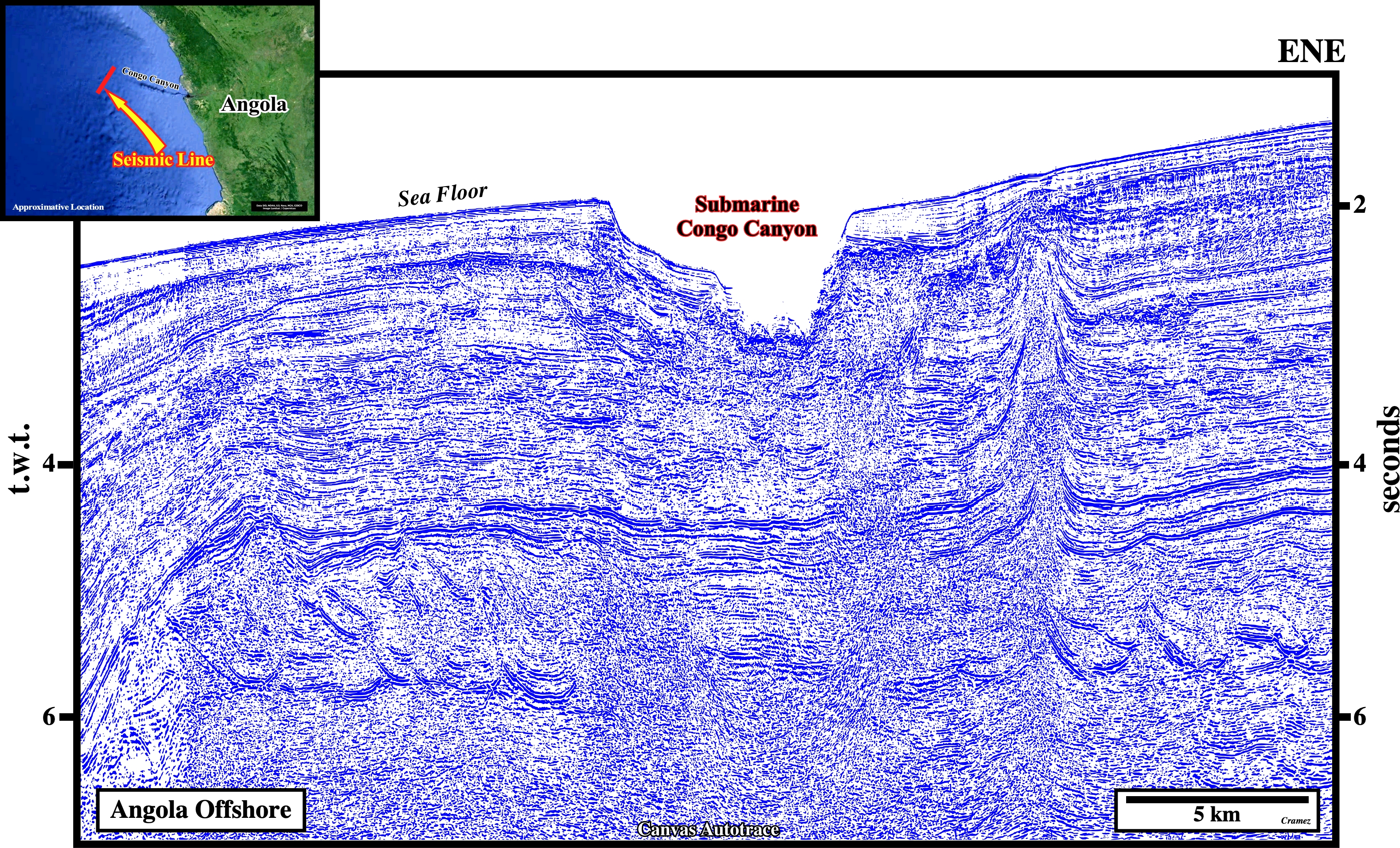
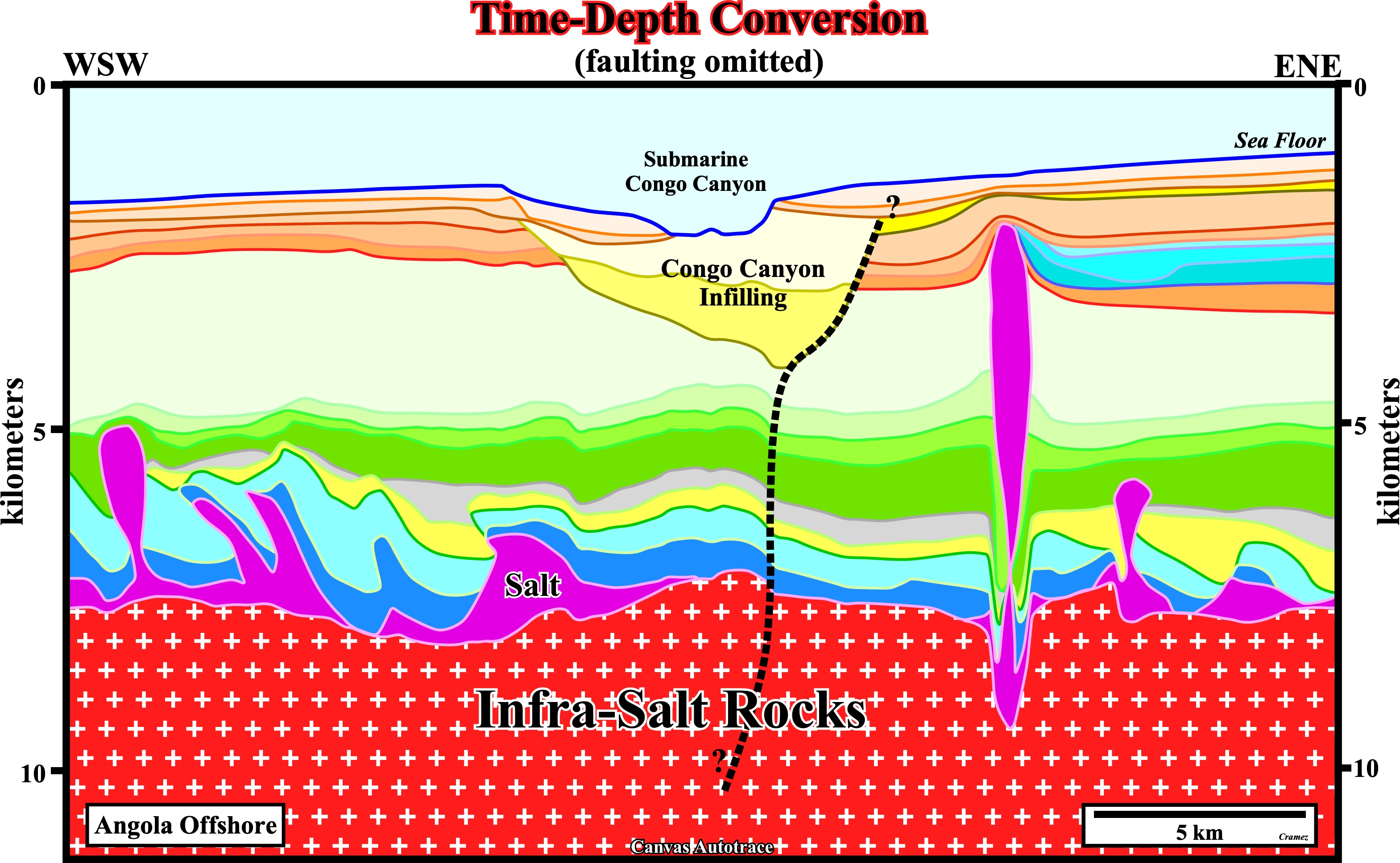
On this tentative geological interpretation of the previous Canvas autotrace (composite seismic line of the Angola offshore) passing trough the Congo canyon, the canyon infilling and underlying seismic intervals were interpreted in a different way. We think the first interpretation (Congo Canyon associated with a fracture zone) is more consistent and more difficult to refute. The alternative interpretation illustrated here above is easier falsifiable. In fact, the particularity that in time the reflectors below the submarine Congo Canyon are, perfectly, horizontal must be explained, because the velocity of the seismic waves travel, slowly, in the infilling sediments of the submarine canyon, but, also, the depth water change must be taken into account. Obvious, the image given by the seismic line (time section) is far from geological reality. A simple depth interactive interpretation using Geophysical Micro Computer Applications is rich in information as illustrated below.

In this time-depth conversion, just the cover (salt) and overburden were taken into account, the infra-salt rocks were taken, globally, as the infrastructure of the salt layer. On the other hand, faulting was omitted. The first significant information is that, in both interpretations, the salt diapir is to thick. There is is too much salt, which induce an important trough at the bottom of the salt, which must be, more or less, flat. Secondly, the presence below th the canyon infilling of antiform structure, which can be interpreted as a compressional structure created by the reactivation of an old normal fault (bordering a possible rift-type basin) or a major fracture zone. As theory precedes observation (K. Popper, 1934) , geoscientists must always try to mental build a time-depth conversion to test if the proposed time interpretation is coherent with the regional geological setting.
Send E-mails to carlos.cramez@bluewin.ch with comments and suggestions to improve this atlas.
Copyright © 2001 CCramez
Last update:
2022