
West USA Offshore
Oregon Offshore

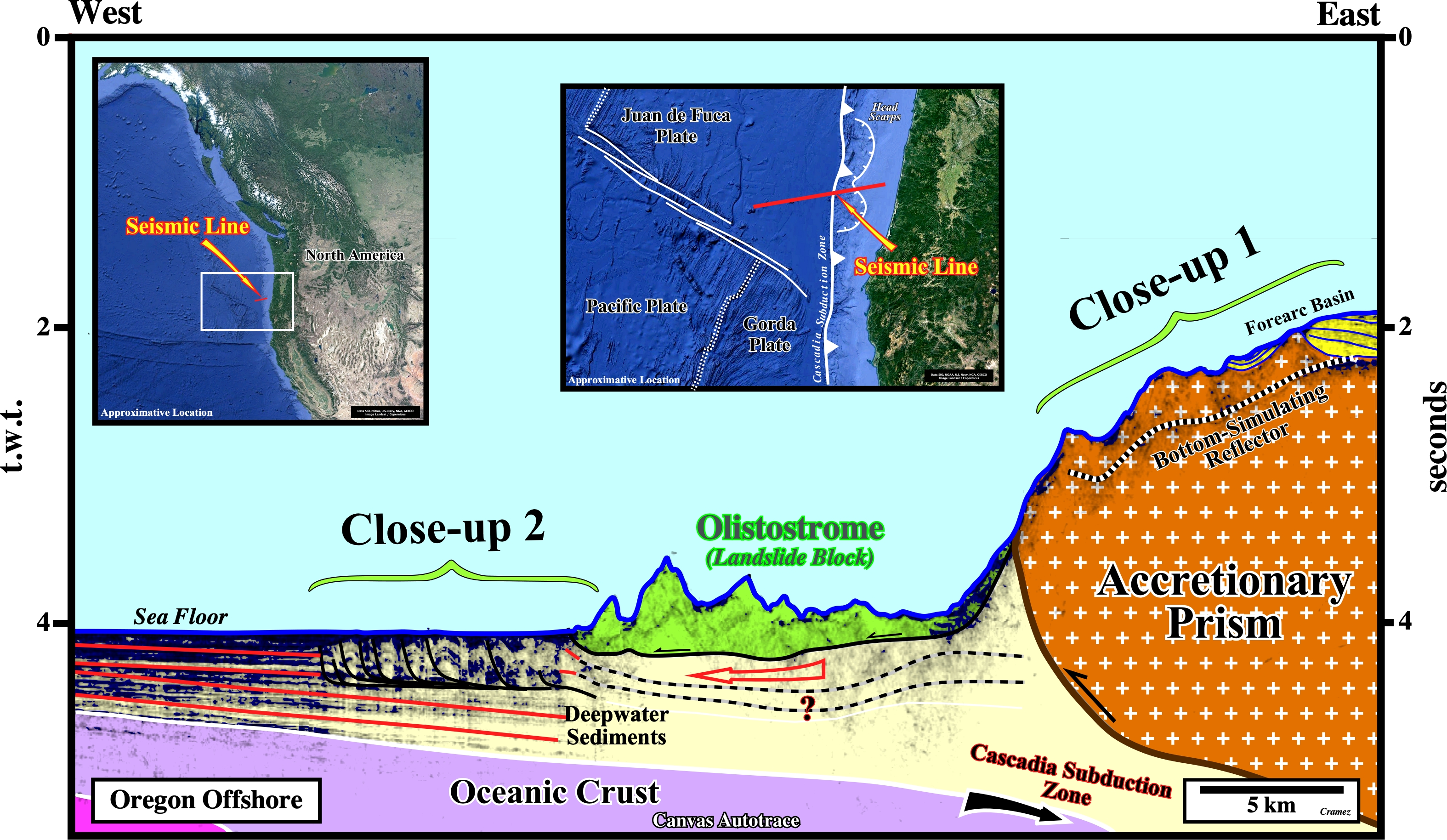
On this tentative geological interpretation of a Canvas autotrace of a seismic line of Oregon offshore, we recognize : (i) The Cascadia subduction zone, in which the Juan Fuca lithospheric plate composed by oceanic crust and deep water pelagic sediments, plunges beneath the North America plate represented, here, by an accretionary prism in which small forearc basins are discernible ; (ii) An eroded continental slope (accretionary prism), in which several sliding scars are visible (see close-up 1) ; (iii) An olistostrome, i.e., landslide deposit composed of a chaotic and heterogeneous material (olistoliths) that accumulates as a semi-fluid body by submarine slumping gravity sliding, coming from the continental slope (accretionary prism) of the North America convergent margin ; (iii) An hypothetical sinking zone of the deepwater pelagic sediments below the landslide mass and (iv) A zone of shortened deepwater sediments seaward of the olistostrome (see close-up 2).

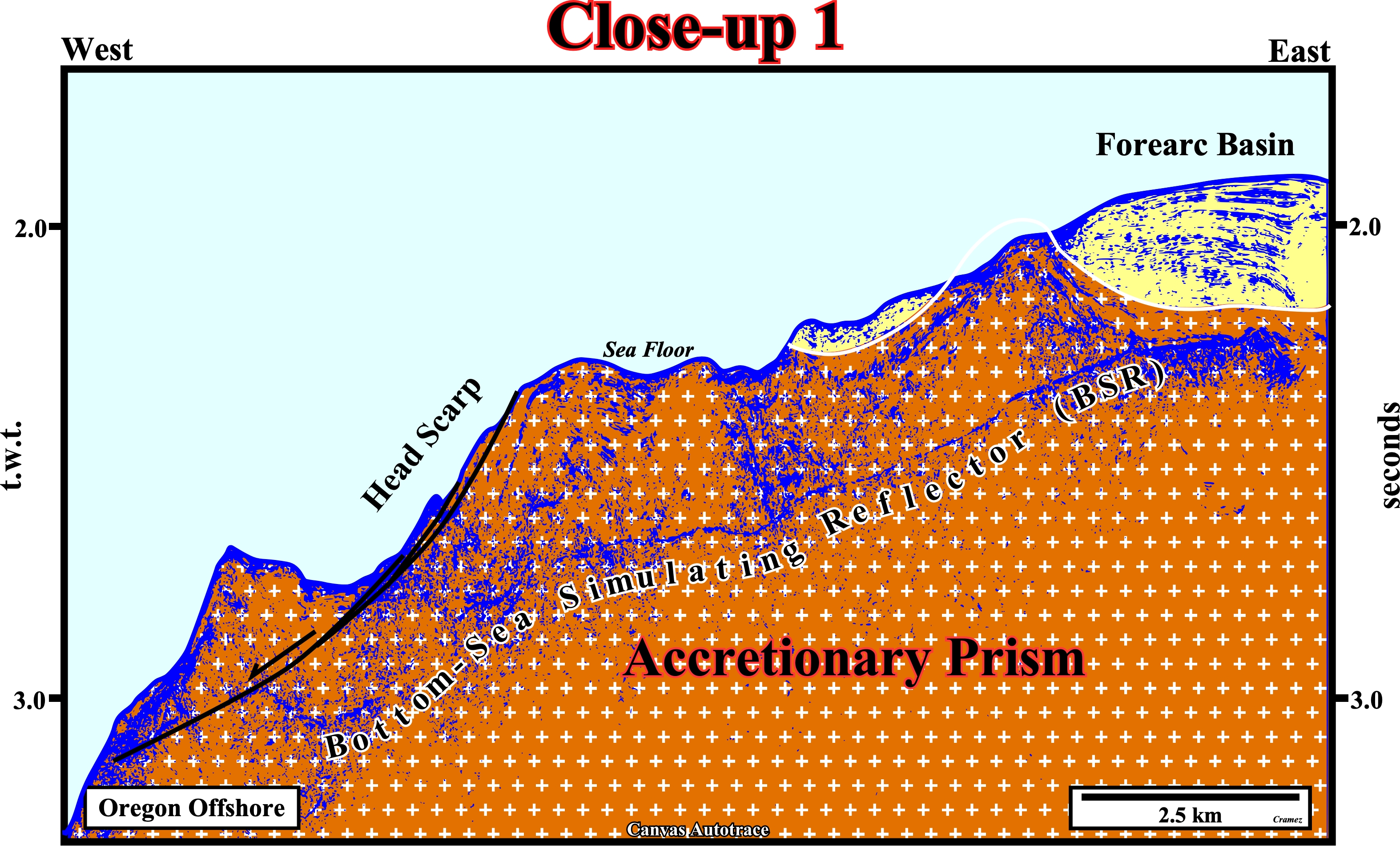
The sea floor morphology of the upper continental slope suggests not only the presence of small forearc basins but the presence of sliding scars as well. The scars are marks left by the landslide blocks (olistoliths) that came down by gravity to the abyssal plain where they deposited forming a large olistostrome (see previous tentative interpretation). The presence of a bottom-sea simulating reflector (BSR) in the accretionary prism of the North America plate makes all underlying potential seismic reflectors obscure. As in many others deepwater basins, the BSR occur at the base of a shallow gas hydrate layer. In spite of the discovery of seafloor gas hydrates, the bottom-simulating reflectors have many problems unsolved, as for instance : (i) They fail to quantify hydrates in the seafloor ; (ii) They fail to indicate hydrate accumulations (Krishna–Godavari geographic basin) ; (iii) Prolific hydrate accumulations located by drilling may not correlate with the direct presence of a BSR at that location (Collett et al., 2008), etc.
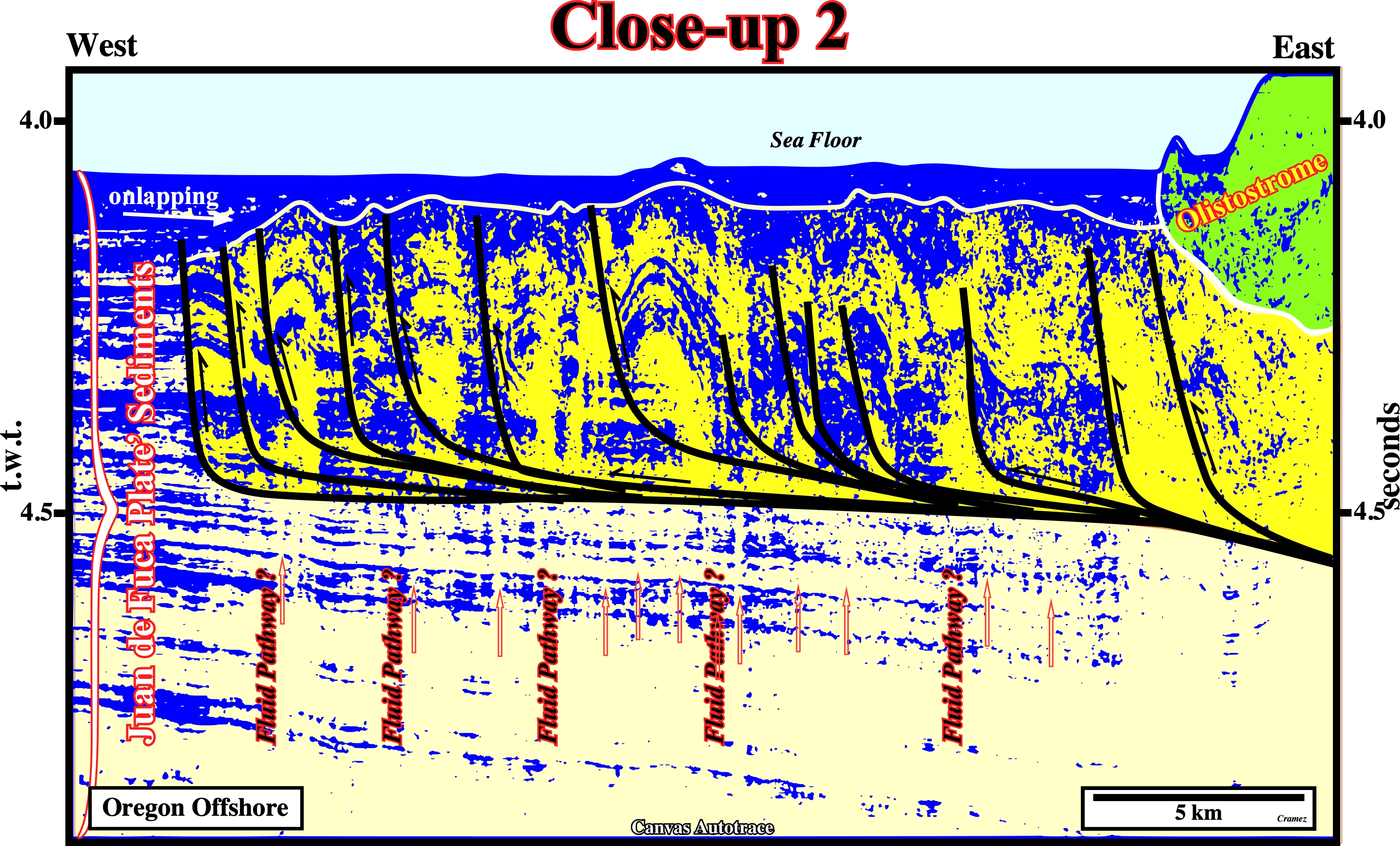
This close-up located on the Juan de Fuca lithospheric plate, seaward of the olistostrome (green interval), illustrates the local shortened area (thrust faults, accompanied by folds in the hanging walls, overlying a decollement surface) induced by the introduction of the olistostrome in the abyssal plain sediments. The decollement surface can be easily explained: assuming that the abyssal plain sediments were at hydrostatic stress conditions prior to the landslide, the pore pressure developed during the undrained loading exceeded the lithostatic stress until a depth of about 275-m below the seafloor (Lenz, B. L, et al., 2018). Notice that such a deformed area is fossilized by the onlapping of undeformed post-gliding sediments (upper left corner of the tentative interpretation), what suggests a quite instantaneous deformation. Below the deformed area the vertical reflection free zone can be interpreted as fluid pathways.

![]()
![]()
Send E-mails to carlos.cramez@bluewin.ch with comments and suggestions to improve this atlas.
Copyright © 2001 CCramez
Last update:
2022
![]()