South Australia Offshore
Bight Geographic Basin
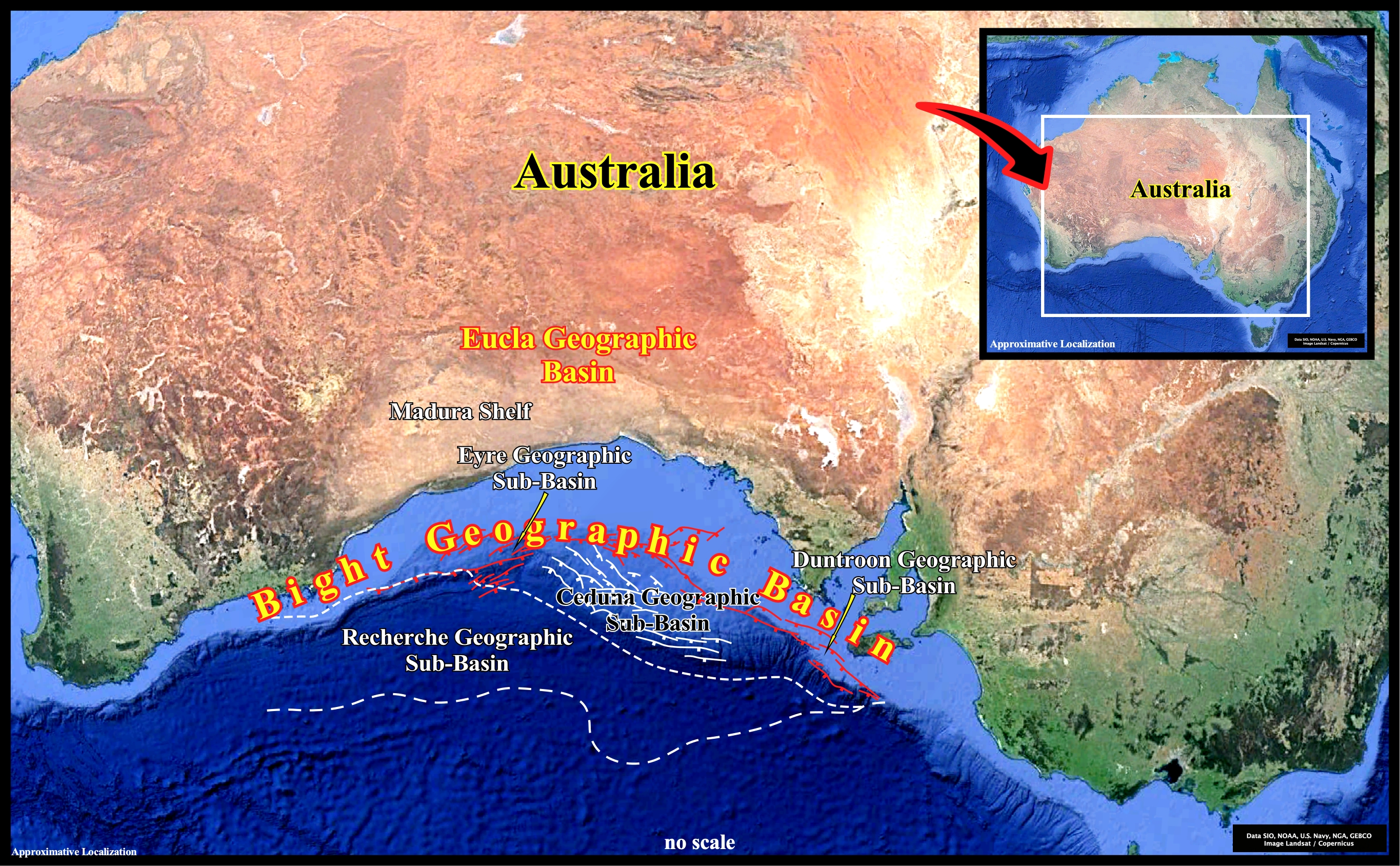
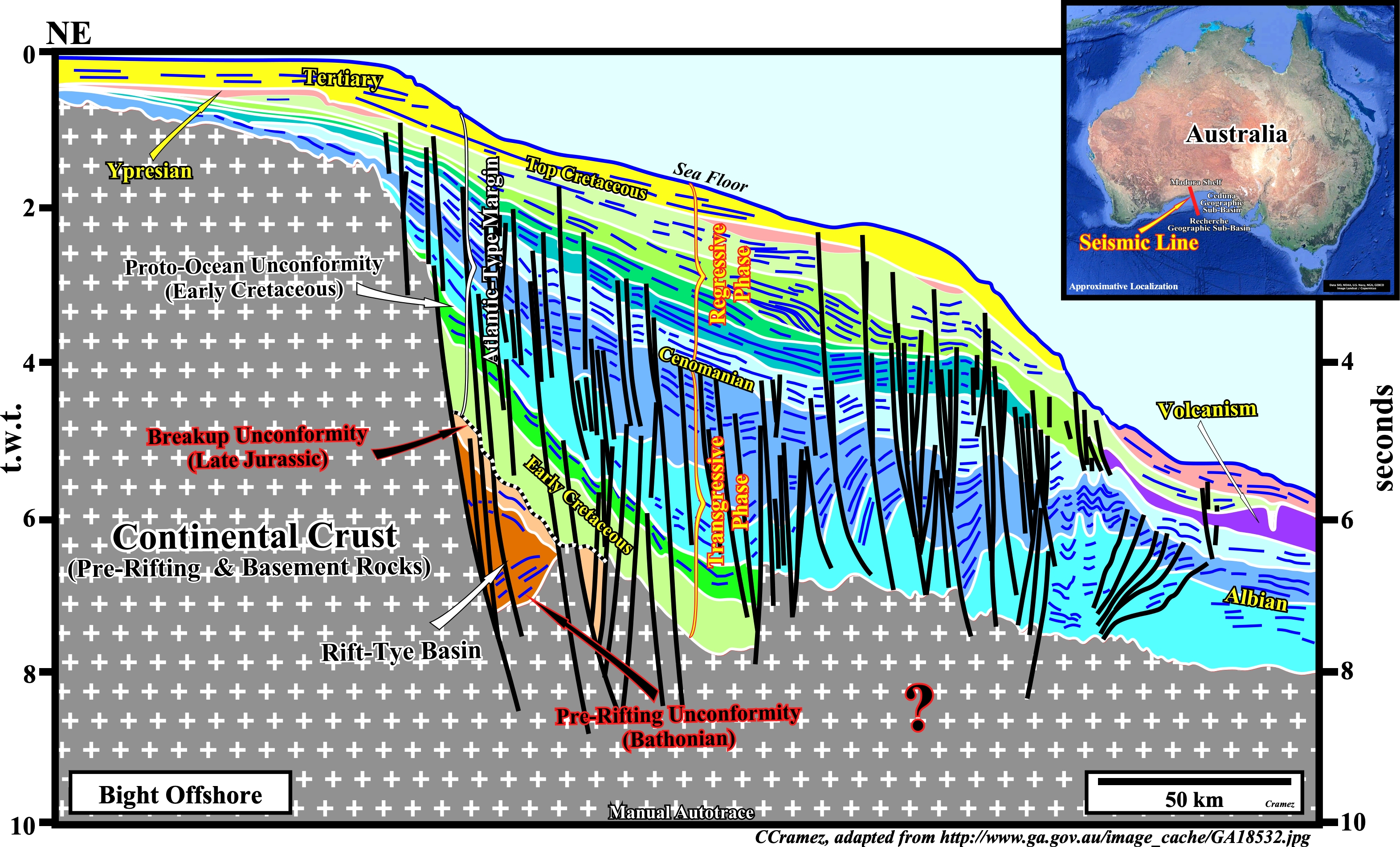
The Bight geographic basin was formed during the lengthening of the lithosphere and subsequent sea floor spreading . Rift-type basins are created before the break-up of the Eastern Gondwana small supercontinent in the Late Jurassic and the Atlantic-type divergent margin, during the sub-aerial and oceanic expansion. In fact, according the plate tectonics paradigm, since large slabs of the Earth's lithosphere split apart from each other (breakup unconformity), probably due to the heat carried via the mantle convection currents, sea floor spreading (sub-aerial and then oceanic), progressively, creates new crust, balancing, roughly, the consumption of the old oceanic crust along the B-type subduction zones. Geological speaking, the Bight geographic basin, correspond to the stacking of rift-type basins, developed during the lengthening of the Pangea lithosphere and the Atlantic-type divergent margin (post-Pangea continental encroachment stratigraphic cycle) developed since the breakup unconformity, i.e., during the oceanic expansion. It extends for more or less 2,000 km along the Australian southern margin and it comprises a series of sedimentary depocenters as Denmark, Bremer, Eyre, Recherche and Ceduna geographic sub-basins.
Taking this tentative geological interpretation as a local geological model, it will be quite easy to recognize the major geological events associated with the lengthening and breakup of the Gondwana lithosphere around Australia offshore : (i) The Gondwana continental crust, i.e., all rocks predating the breakup of the lithosphere, is composed not only by basement and pre-rifting rocks, but also those deposited during the lengthening of the supercontinent, that is to say, by the rocks infilling the rift-type basins ; (ii) The pre-rifting unconformity, which highlights the onset of the lengthening of the lithosphere (beginning of the rifting), seems to have, here, a Middle-Jurassic age (Bathonian) ; (iii) The breakup unconformity marks the ended of the rifting and the beginning of the seafloor spreading. ; (iv) The sea floor spreading starts, generally, by a sub-aerial phase (deposition of lava flows, which , later, are tilted seaward), before become, completely, oceanic (formation of the oceanic crust s.s.) ; (v) volcanic expansion (sub-aerial or oceanic), was not taken into account on this tentative geological interpretation ; (vi) The breakup unconformity or correlative seismic surface underlines the limit between rift-type basins and the overlying Atlantic-type divergent margin in which the post-Pangea continental encroachment stratigraphic cycle is deposited in association with the second 1st order Phanerozoic eustatic cycle ; (vi) Two stratigraphic phase compose the post-Pangea continental encroachment cycle, i.e., a transgressive phase with a retrogradational geometry (predominantly upbuilding) and a regressive phase with a typical forestepping geometry (predominantly outbuilding).

The geological model described adopted, on the previous tentative interpretation, seems to be corroborated on this manual autotrace of a seismic line crossing the Eyre and Recherche geographic sub-basins. However, the position of the breakup unconformity, separating the lengthened Pangea continental crust, in which the rift-type basins are developed, from the Atlantic-type divergent margin, is conjectural since certain geoscientists consider several phases of rifting.
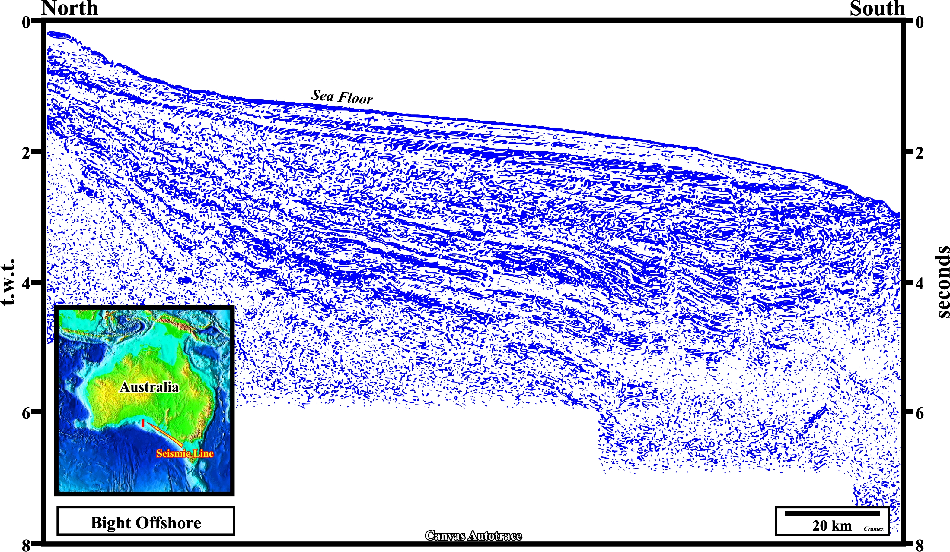
Taking into account the previous geological model, i.e., as "Theory precedes Observation" (K. Popper, 1934), even Canvas autotraces of very bad seismic lines (poor seismic data), as the one illustrated here, it can be partially interpreted, since geoscientists knowing, a priori, what they must look for, generally, they can recognize the major characteristic geological events. In fact, above breakup unconformity, which is not too well marked (see next Canvas autotrace), the post-Pangea continental encroachment stratigraphic cycle can, easily to be recognized, as well as its transgressive and regressive phases.
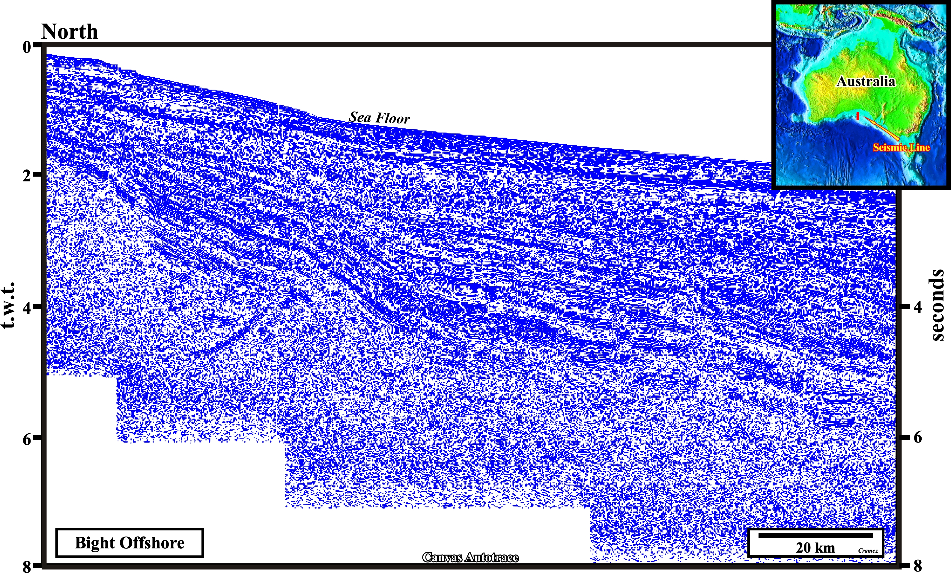
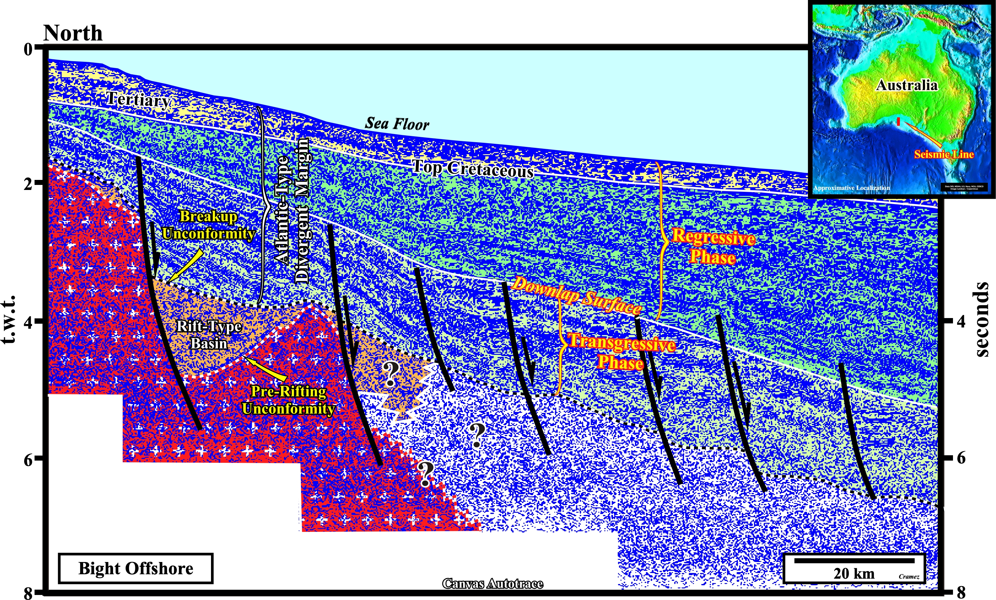
This Canvas autotrace of a seismic line, roughly, parallel to the previous one, corroborate, i.e, does not falsify the geological model assumed before: (i) The breakup unconformity, which is the upper boundary of the rift-type basins that lengthened the Pangea supercontinent prior to the break-up, is clearly, recognized on the lower left side of the autotrace ; (ii) Similarly, the pre-rifting unconformity, that marks the onset of the rifting (lengthening during which rift-type basins are developed) is, easily, recognized below the breakup unconformity in the lower left part of the autotrace (± 4.7 seconds t.w.t.) ; (iii) Overlying the breakup unconformity, the Atlantic-type divergent margin covers the rift-type basins or the pre-rifting rocks (often basement) ; (iv) The stratigraphic transgressive phase, characterized, mainly, by a retrogradational geometry (upbuilding preponderant) and the stratigraphic regressive phase, characterized by a predominant progradational geometry (outbuilding preponderant) are limited without major difficult, since the interface corresponds to a major downlap surface.
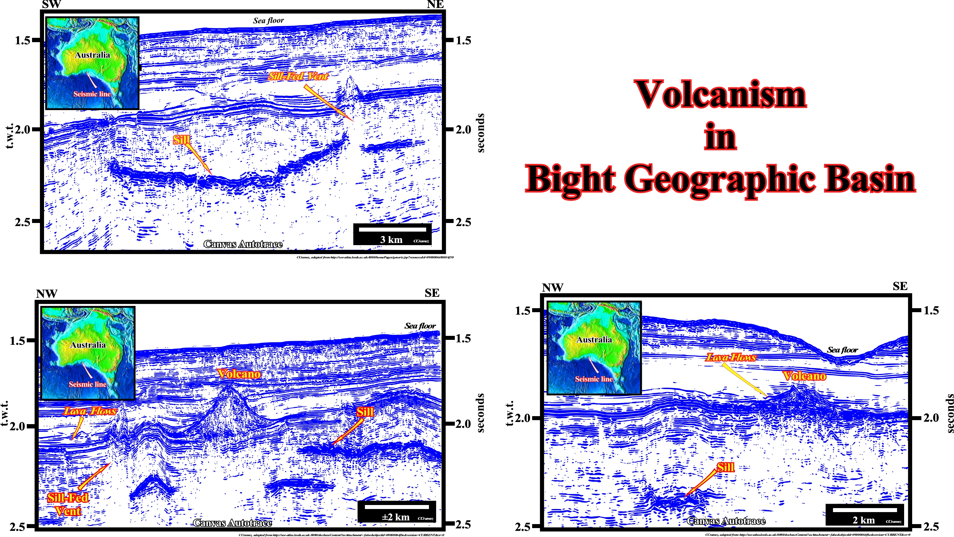
We should note the occurrence of volcanism in the Atlantic-type margin of the Bight geographic basin as indicated on the tentative geological interpretation taken as a local geological model shown on top of this Page, under the location map of the Bight geographic basin. As illustrated on these autotraces, this volcanism can not be confused with the lava-flows (SDRs) forming the initial sub-aerial phase of the seafloor spreading, which are well visible on the majority of the regional seismic line of the Australia offshore. In addition such volcanism is presented under quite different forms, which is not the case of the seaward dipping reflectors (SDRs) : (i) Volcanoes and particularly strato-volcano, i.e, more or less tall conical mountains built-up by small lava flows and tephra (fragmental material produced by a volcanic eruption) ; (ii) Sills (more or less tabular sheet intrusion that has intruded between older layers of sedimentary rock, which are fed by dikes) and ; (iii) Sill-fed vents.

![]()
![]()
Send E-mails to carlos.cramez@bluewin.ch with comments and suggestions to improve this atlas.
Copyright © 2001 CCramez
Last update:
2022![]()