
West Tasmania Offshore
Sorrel Geographic Basin
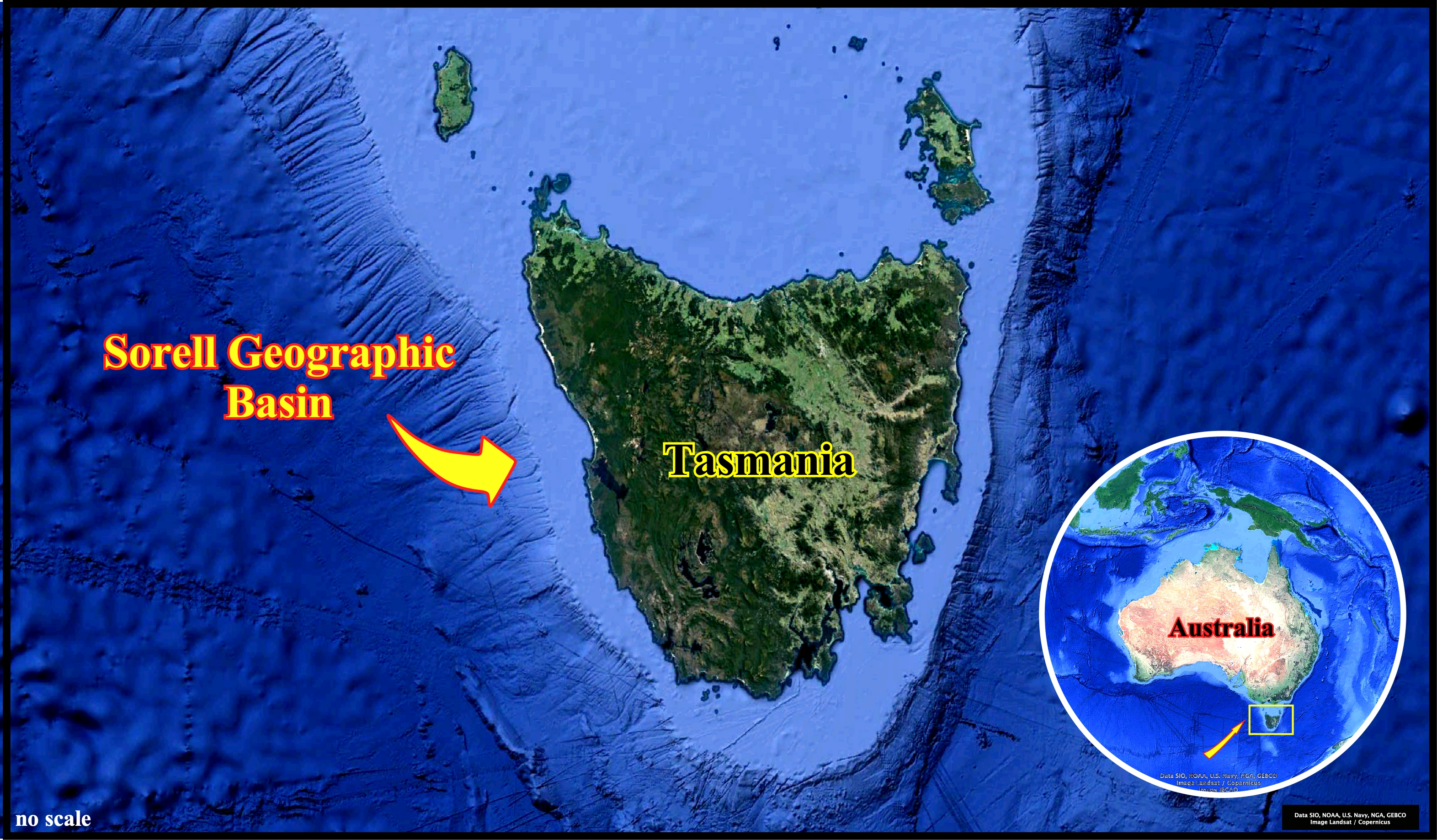
The Mesozoic / Cenozoic Sorell geographic basin comprises a series of north-northwest trending transtensional depocenters underlying parts of the western continental shelf and continental slope of Tasmania. The basin, which is contiguous with the Otway geographic basin, contains, mainly, non-marine sediments (fluvial and red beds) of the rift-type basins, which are overlain by younger post-rift paralic and shallow marine siliciclastics and carbonates. The geological context of the area can be summarized as follows : (i) The Sorell geographic basin was initiated in the Late Jurassic to Early Cretaceous. ; (ii) The lengthening system (rifting phase) led to the lithosphere break up of Australia and Antarctica ; (iii) The initial lengthening phase was followed in the Aptian–Albian by a widespread, early post-rifting sag phase ; (iv) A period of regional inversion followed in the Cenomanian ; (v) In the eastern Otway and northern Sorell basins, resumption of rifting resulted in deposition of Cenomanian to Maastrichtian shallow marine to fluvial sediments ; (vi) Moderate uplift of the rift flanks occurred during the initiation of sea-floor spreading off western Tasmania ; (vii) Progressive collapse of the margin occurred as seafloor spreading propagated southwards, and resulted in the deposition of thick prograding Paleocene sequences in the north, followed by similarly thick Eocene sequences further south ; (viii) Subsequent north–south oriented plate movement between Australia and Antarctica during the Middle to Late Eocene resulted in the formation of a transform plate margin and the Australo-Antarctic Gulf, a narrow restricted seaway along western Tasmania ; (ix) Clearance between the Australian and Antarctic plates occurred around 34 Ma (Eocene/Oligocene boundary) resulting in the development of circum-Antarctic ocean currents—an event recorded by a regional unconformity ; (x) From the Late Oligocene to Pleistocene, open marine conditions prevailed in the Sorell Basin.
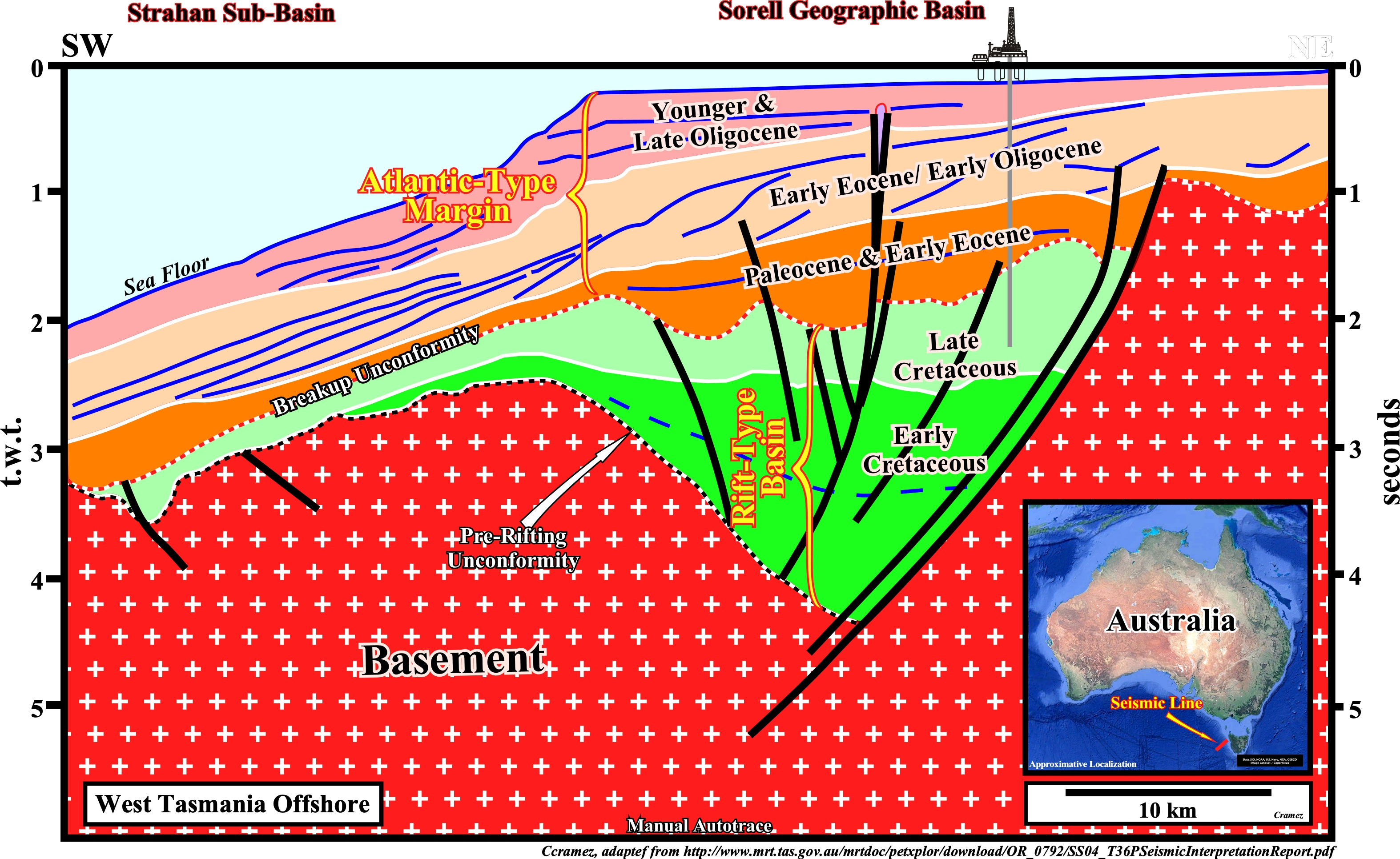
Knowing the geological context of the area (see previous plate), the tentative geological interpretation of a manual autotrace of a seismic line crossing the Sorrel geographic basin and Strahan sub-basin is quite evident. The pre-rifting unconformity, i.e., the bottom of the rift-type basins sediments is obvious taking into account its deformation (lengthening). The breakup unconformity is characterized by the end of the differential subsidence (top Late Cretaceous). Between the breakup unconformity and the sea floor, Cenozoic sediments form the Atlantic-type divergent margin. The deposition of margin sediments was induced by the post-Pangea continental encroachment stratigraphic cycle, in which the space available for the sediments (accommodation) was, mainly, induced by thermal subsidence and the deposition cyclicity created by the eustasy (sea level variations regardless of their causes).
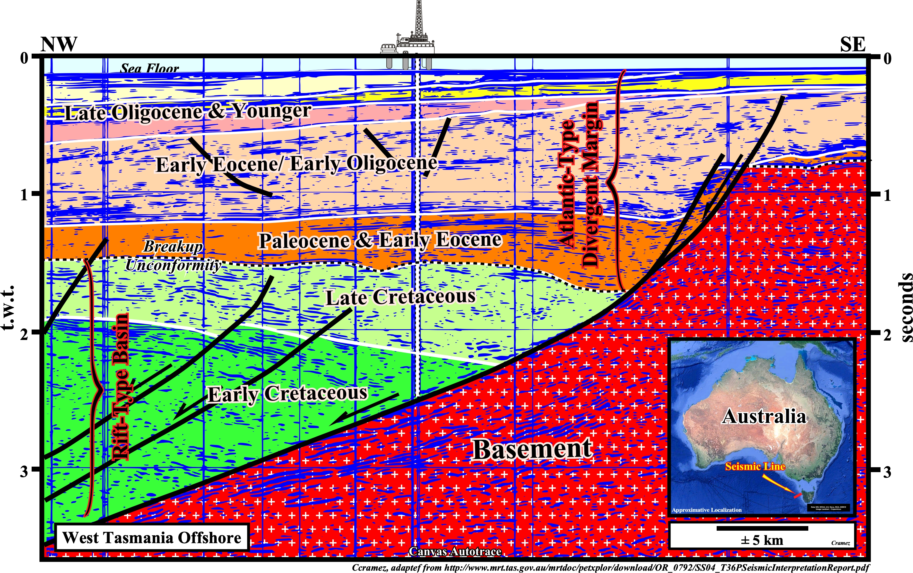
On this autotrace, the lengthening of the Pangea continental crust is highlighted by a Cretaceous rift-type basin, which is limited by the normal fault bordering the half-graben structure, as it is the case in the previous tentative interpretation. Contrariwise, the Paleocene / Early Eocene interval (colored in dark brown), which was deposited all over the area, particularly, eastward the rift-type basin, is considered as belonging to the Atlantic-type divergent margin, which overly the rift-type basin. In other words, the breakup unconformity seems correspond, more or less, to the top Cretaceous. However, taking into account the abrupt thickness changes of the Cenozoic sedimentary packages, it is evident that the bordering normal fault of the rift-type basin played, several times during the deposition of the post-Pangea continental encroachment stratigraphic cycle, i.e, during the margin development. The internal configuration of seismic reflectors of the rift-type basin being divergent toward the bordering fault suggests a preponderant sandy lithology, since the accommodation (space available for the sediments) is always balanced by the terrigeneous influx. As, often, pointed out by A. Bally : with such an internal configuration the chances of found source-rocks is quite small.

![]()
![]()
Send E-mails to carlos.cramez@bluewin.ch with comments and suggestions to improve this atlas.
Copyright © 2001 CCramez
Last update:
2022![]()