
West Australia Offshore
Wallaby Offshore
The Wallaby Plateau, also known as the Cuvier Plateau, is a large bathymetric high about 450 kilometers west of Carnarvon, in Western Australia. Early studies assigned a variety of origins and characteristics to the Wallaby Plateau ranging from a largely continental body (Symonds and Cameron, 1977) to a volcanic buildup formed on oceanic crust (Veevers and Cotterill, 1978). Later studies based largely on the seismic reflection data and geodynamic reconstructions (Mihut and Müller, 1998; Symonds et al., 1998 ; Müller et al., 2002 ; Sayers et al., 2002) proposed that it is a composite feature cored by areas of extended continental crust that have been modified and blanketed by voluminous volcanic rocks. This volcanism occurred during the breakup between Australia and Greater India and the development of the lithospheric-scale Wallaby-Zenith Fracture Zone along the southern margin of the plateau (Figures 1 and 2; Symonds and Cameron, 1977).

This tentative interpretation shows that in the deep offshore lava-flows (SDRs) and the oceanic crust are predominant. The lava-flows postdate the breakup unconformity (BUU) , which caps the rift-type basins, developed during the lengthening of the lithosphere (the crust stretched until a normal faulting system occurs decreasing its thickness and creating rift-type basins). As depicted above, the SDRs correspond to a lateral volcanic accretion of the new lithospheric plate, i.e., following the breakup of the lithosphere (generally, made by an excess of volcanic intrusions), while the expansion centers are operating in the air, they effuse lava which flows continentward. Since the expansion centers become immersed, as lava cannot flow anymore, it solidified forming pillow-lava, i.e., oceanic crust.

The formation of this offshore seems to be initiated ± 155 Ma (Upper Jurassic) when Australia broke apart the Burma plate, however it was not until ± 135 Ma (Lower Cretaceous) that India broke from western Australia, forming the central and southern offshores of the Exmouth Plateau now known as the Gascoyne and Cuvier Abyssal Plains. In the western part of this tentative interpretation of a seismic line of West Exmouth Plateau, we recognize the Late Jurassic / Early Cretaceous break apart of the Eastern Gondwana small supercontinent (Madagascar, India, Antarctic and Australia). The basement and Paleozoic pre-rifting strata are recognized, easily, as well as, the Mesozoic rifting strata (rift-type basins). Above the breakup unconformity (BUU), in this distal area, the Atlantic-type divergent margin is, mainly, represented by thin deep water Cenozoic interval. As depicted, it is likely that the breakup was the resulted of an exaggerated injection of mantle material in a thin continental crust. Following the breakup the new lithospheric plates were, laterally, accreted by lava-flows (sub-aerial volcanic crust) and oceanic crust as illustrated on detail 1 and 2.

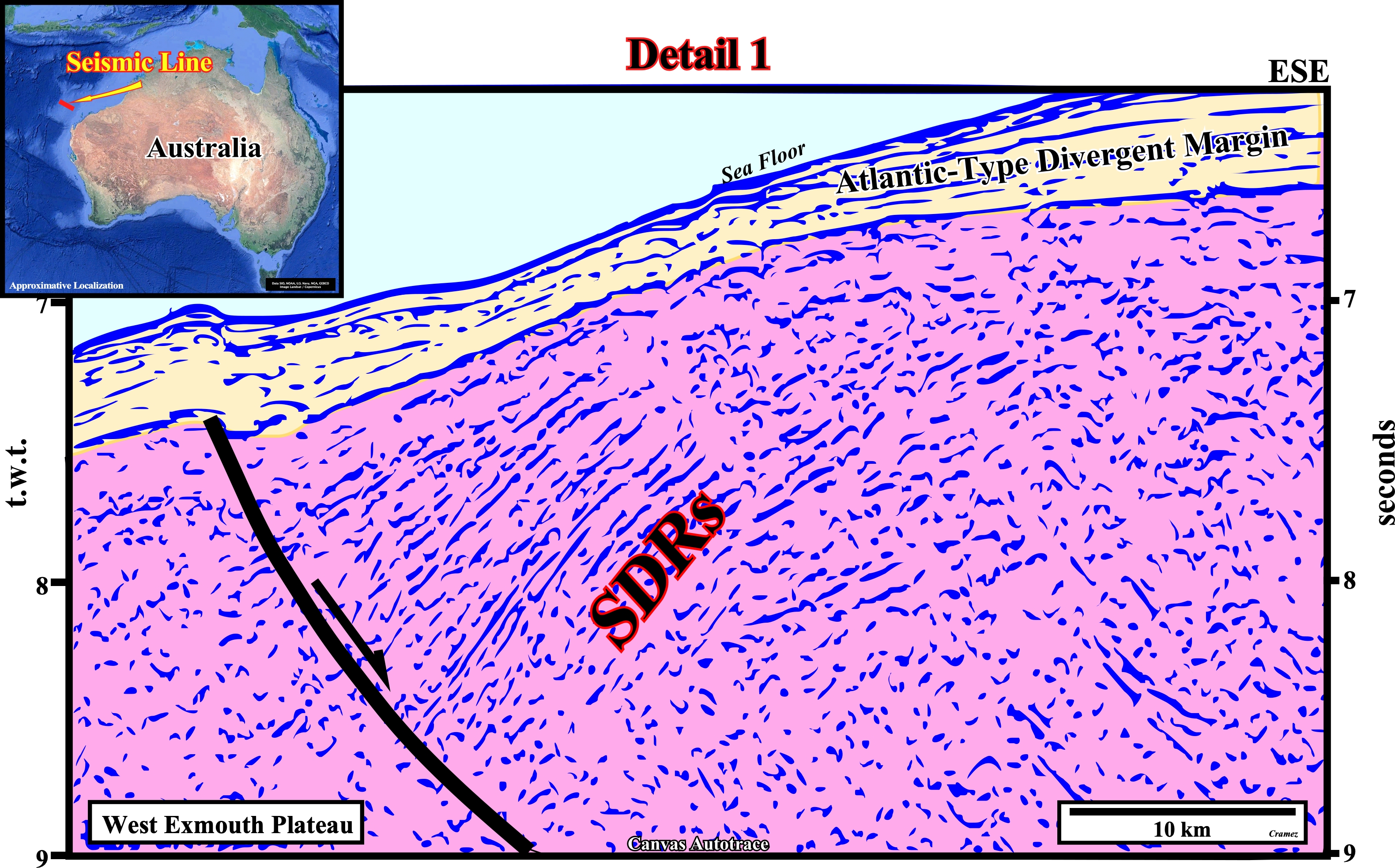
These seaward dipping reflectors can be interpreted as lava-flows pour out from sub-aerial expansion centers (volcanoes and fissures aligned parallel to the breaking zone) and thinning continentward. They postdate the lithosphere's break-up. These volcanic-flows can reach more than 10 km in thickness. On seismic profiles perpendicular to the breakup zone, the SDRs are convex upward, with slopes and thicknesses increasing basinward, as illustrated on this detail. The seaward tilting results from the overload of the most recent flows, which, progressively, move basinward. On seismic line parallel to the breakup zone, the SDRs are sub-horizontal. Generally, the SDRs form a band with little accentuated magnetism, located upstream of the oldest magnetic anomaly of the oceanic crust. As the new lithospheric plates move away from the mantle plume, the successive volcanic-flows cool and sink, putting under water the spreading centers, i.e., volcanoes and sheeted dikes. As the flow of volcanic material is impossible under the water, since a lava-flow reaches the sea floor, it solidifies, quickly, forming the true oceanic crust (pillow lavas), characterized by obvious magnetic anomalies and, on the seismic lines, by chaotic reflectors ads illustrated on next autotrace.
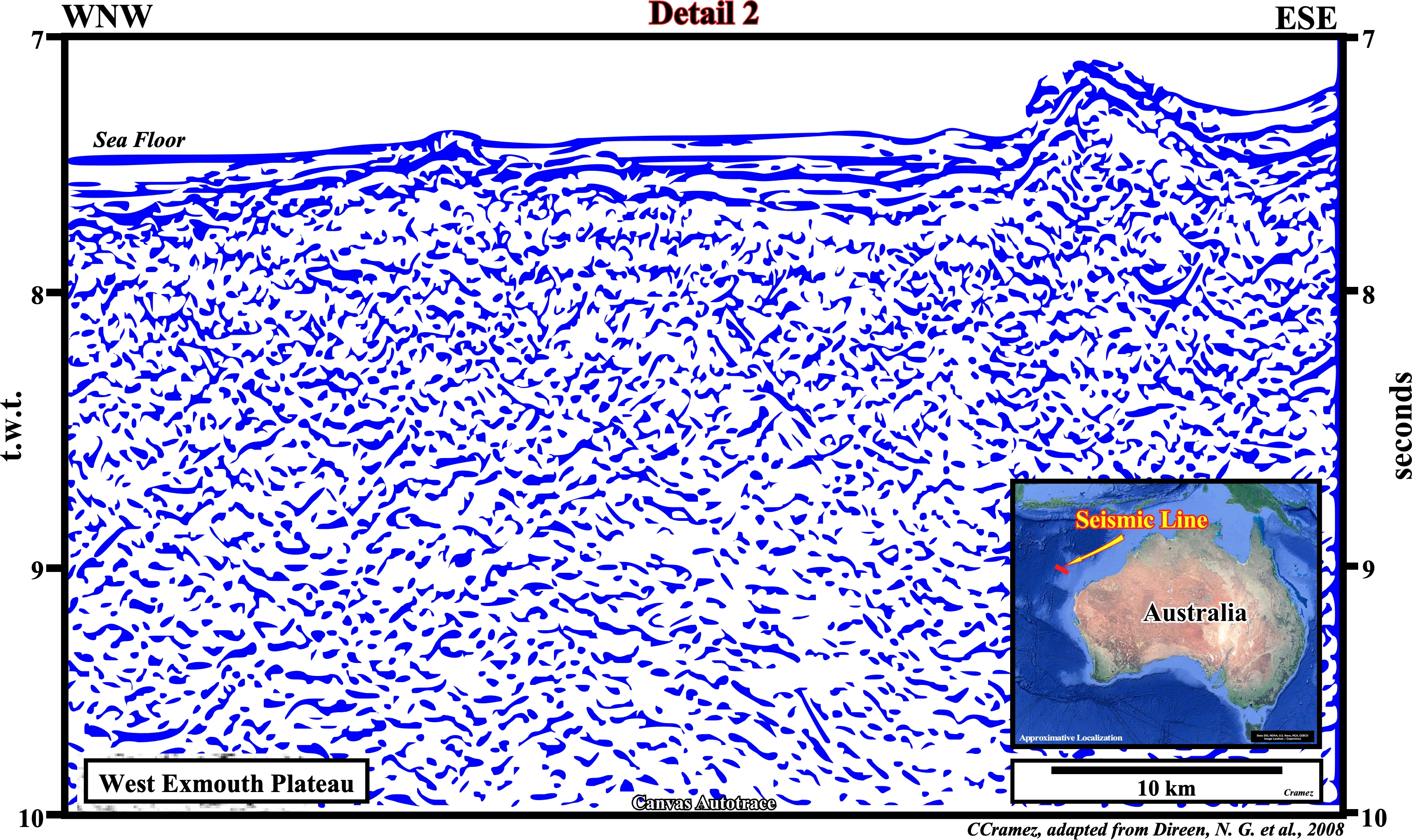

This autotrace illustrates the chaotic configuration of the oceanic crust overlaid, here, by a thin sedimentary interval. The oceanic crust, which can reach 5-10 km of thickness, is the outermost solid layer of a lithospheric plate. Lithologically, it has a basaltic composition with relatively low concentrations of potassium and other trace elements. The oceanic crust consists, mainly, of three layers: (1) A relatively thin uppermost volcanic layer of basaltic lavas erupted on the seafloor (pillow-lava) ; (2) a thicker layer of more coarsely crystalline, intrusive basaltic dikes (sheeted dikes) that feed the volcanic layer (pillow lava) ; and (3) a thick lowermost layer of intrusive coarse-grained gabbros that mostly represent minerals that have settled out of slowly cooled melt bodies and lenses in a crystal mush zone below ridge crests (https://link.springer.com/referenceworkentry/10.1007%2F978-3-319-39312-4_266).

![]()
![]()
Send E-mails to carlos.cramez@bluewin.ch with comments and suggestions to improve this atlas.
Copyright © 2001 CCramez
Last update:
2022![]()