
South Australia Offshore
Bight Geographic Basin (Ceduna Sub-basin)
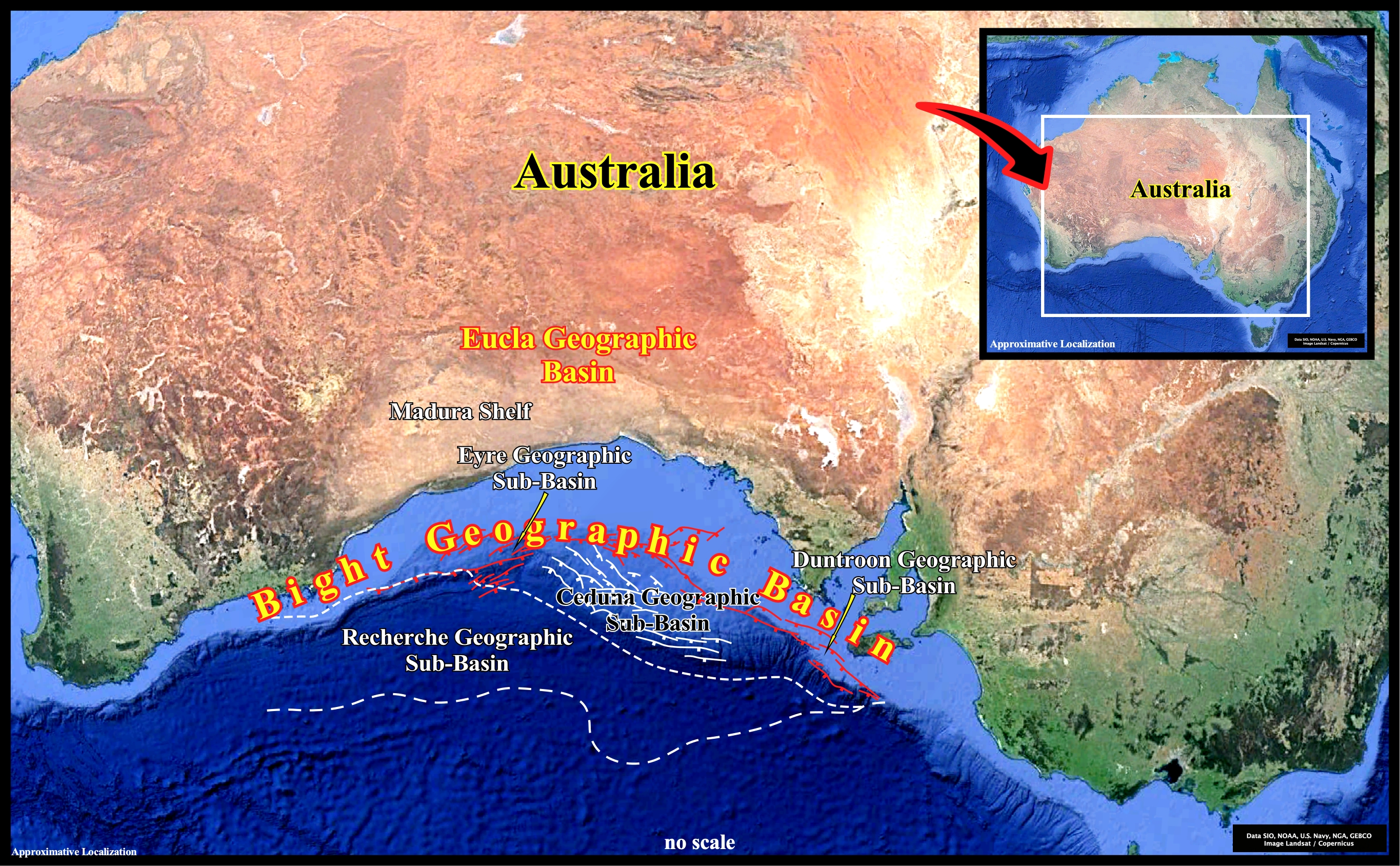
The Bight geographic basin was formed during the lengthening of the lithosphere and subsequent sea floor spreading . Rift-type basins are created before the break-up of the Eastern Gondwana small supercontinent in the Late Jurassic and the Atlantic-type divergent margin, during the sub-aerial and oceanic expansion. In fact, according the plate tectonics paradigm, since large slabs of the Earth's lithosphere split apart from each other (breakup unconformity), probably due to the heat carried via the mantle convection currents, sea floor spreading (sub-aerial and then oceanic), progressively, creates new crust, balancing, roughly, the consumption of the old oceanic crust along the B-type subduction zones. Geological speaking, the Bight geographic basin, correspond to the stacking of rift-type basins, developed during the lengthening of the Pangea lithosphere and the Atlantic-type divergent margin (post-Pangea continental encroachment stratigraphic cycle) developed since the breakup unconformity, i.e., during the oceanic expansion. It extends for more or less 2 000 km along the Australian southern margin and it comprises a series of sedimentary depocenters as Denmark, Bremer, Eyre, Recherche and Ceduna geographic sub-basins.
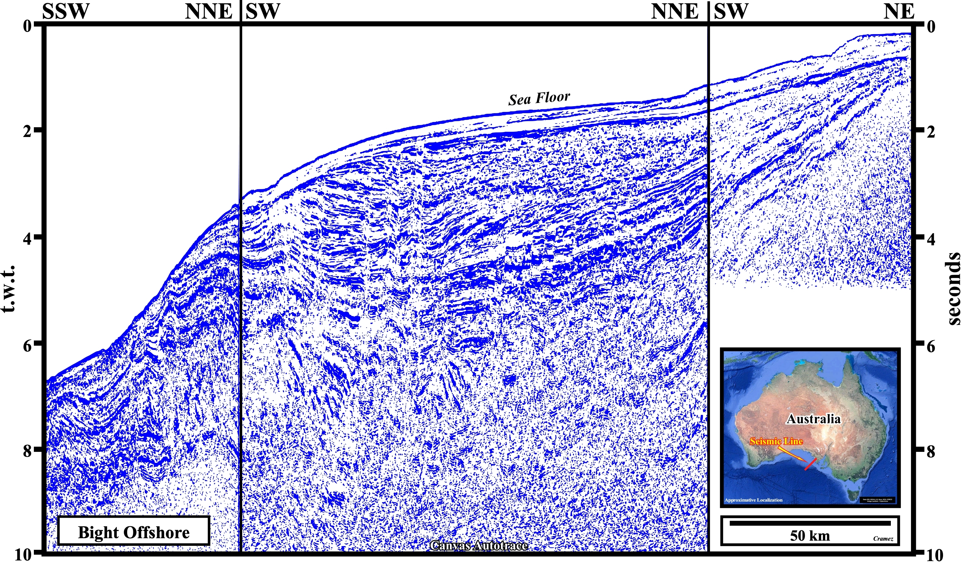
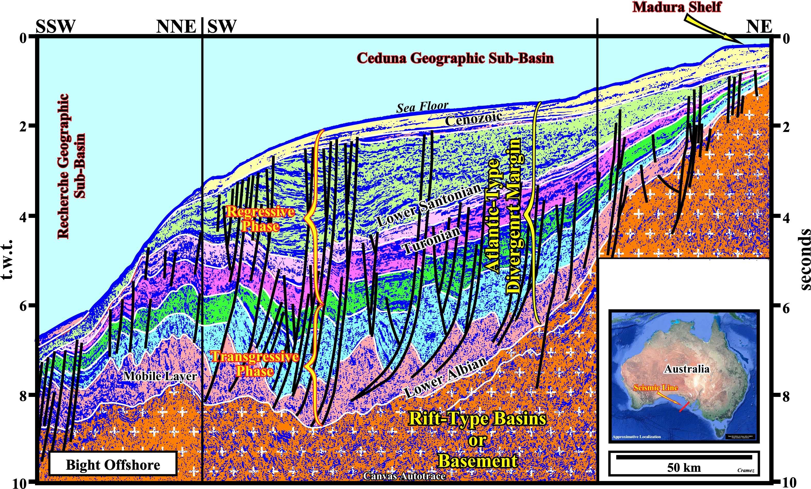
The first thing to take into account on this tentative interpretation is the seismic pitfall induced by the progressive increasing of the water depth. In a Canvas autotrace of a depth time version of the original composite seismic line, the chronostratigraphic seismic surfaces are less tilted seaward, particular, those of the southern part of the section. Secondly, the lengthened continental crust of Gondwana small supercontinent, i.e., the pre-rifting rocks (substratum and basement) and the rifting rocks (strata infilling the rift-type basins) was considered as a single geological unity, limited upward by the breakup unconformity, over which the Mesozoic Atlantic-type divergent margin was deposited (Cenozoic strata is quit thin). The two stratigraphic phases of the Atlantic-type margin are, easily, recognized. The sedimentary packages predating the Turonian are, mainly, retrogradational (upbuilding predominant), while the upper ones have a progradational internal geometry thickening seaward. Do not forget that the Gondwana is a small supercontinent. The really supercontinent is the Pangea, which is formed by two small supercontinents, the Gondwana (containing the southern continents : South America, Africa, India, Madagascar, Australia, and Antarctica) and the Laurasia (composed by the northern continents : North America, Greenland, Europe, and northern Asia).
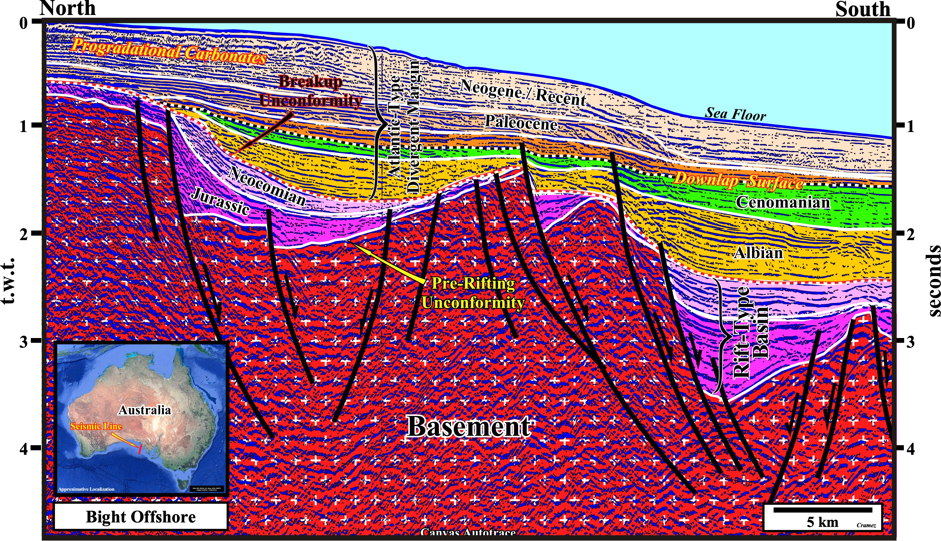
As illustrated on this Canvas autotrace, in certain seismic lines the picking of the breakup unconformity, which, generally, bounds two different realms of subsidence, i.e., which highlights the limit between a preponderant continentward differential subsidence (lengthening of the lithosphere with development of rift-type basins, which predate the breakup) and a preponderant thermal seaward subsidence inducing the deposition of post-Pangea continental encroachment stratigraphic cycle (Atlantic-type margin) is not always quite evident. In fact, certain geoscientists even consider the possibility of two phases of rifting. In this particular case, we hypothesized the beginning of the thermal subsidence (onset of oceanization, i.e., beginning of the sea floor) at the top Neocomian. In the Atlantic-type divergent margin, above the downlap surface that limits the two continental encroachment stratigraphic phases (transgressive and regressive phases), Cenozoic progradational carbonates are preponderant.
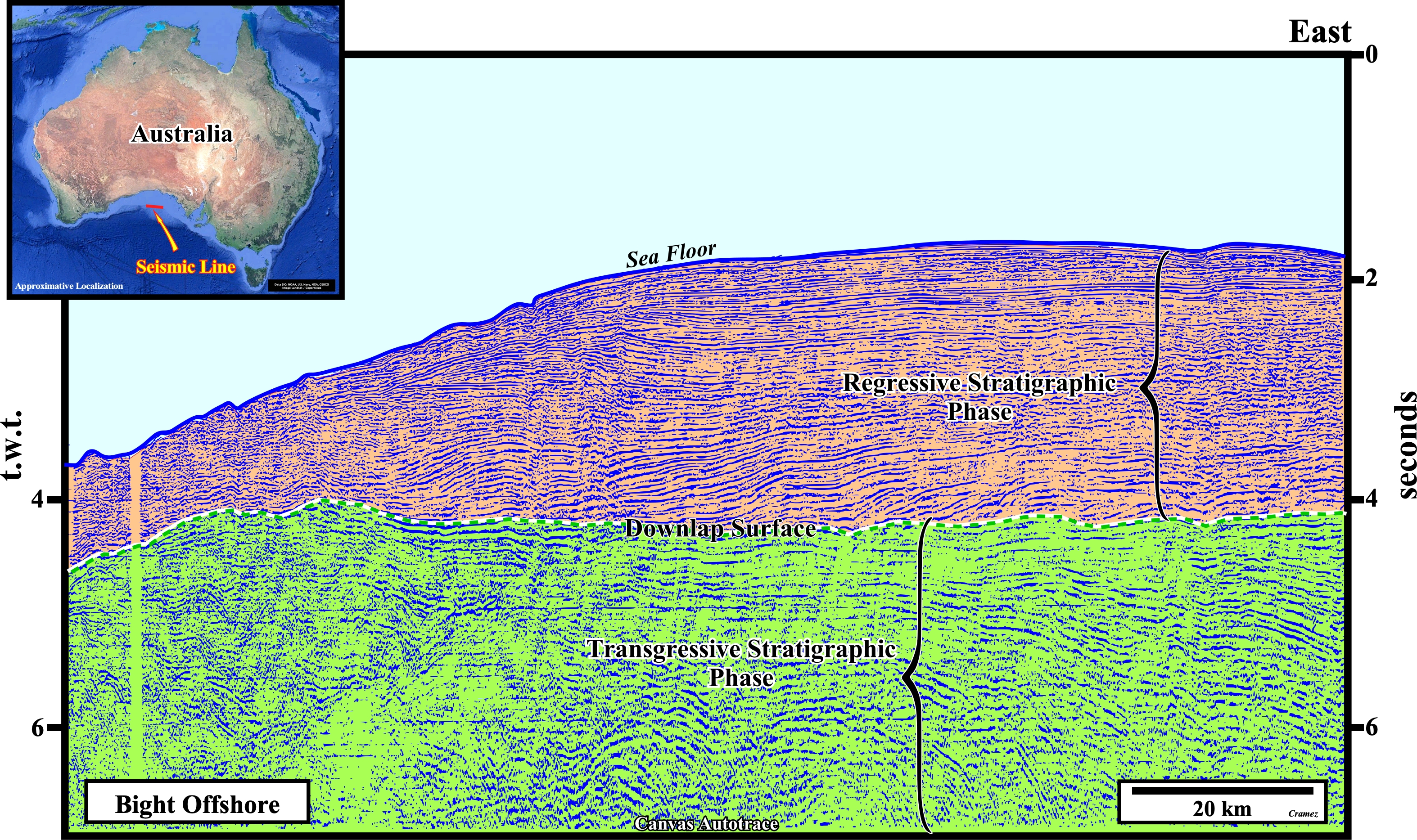
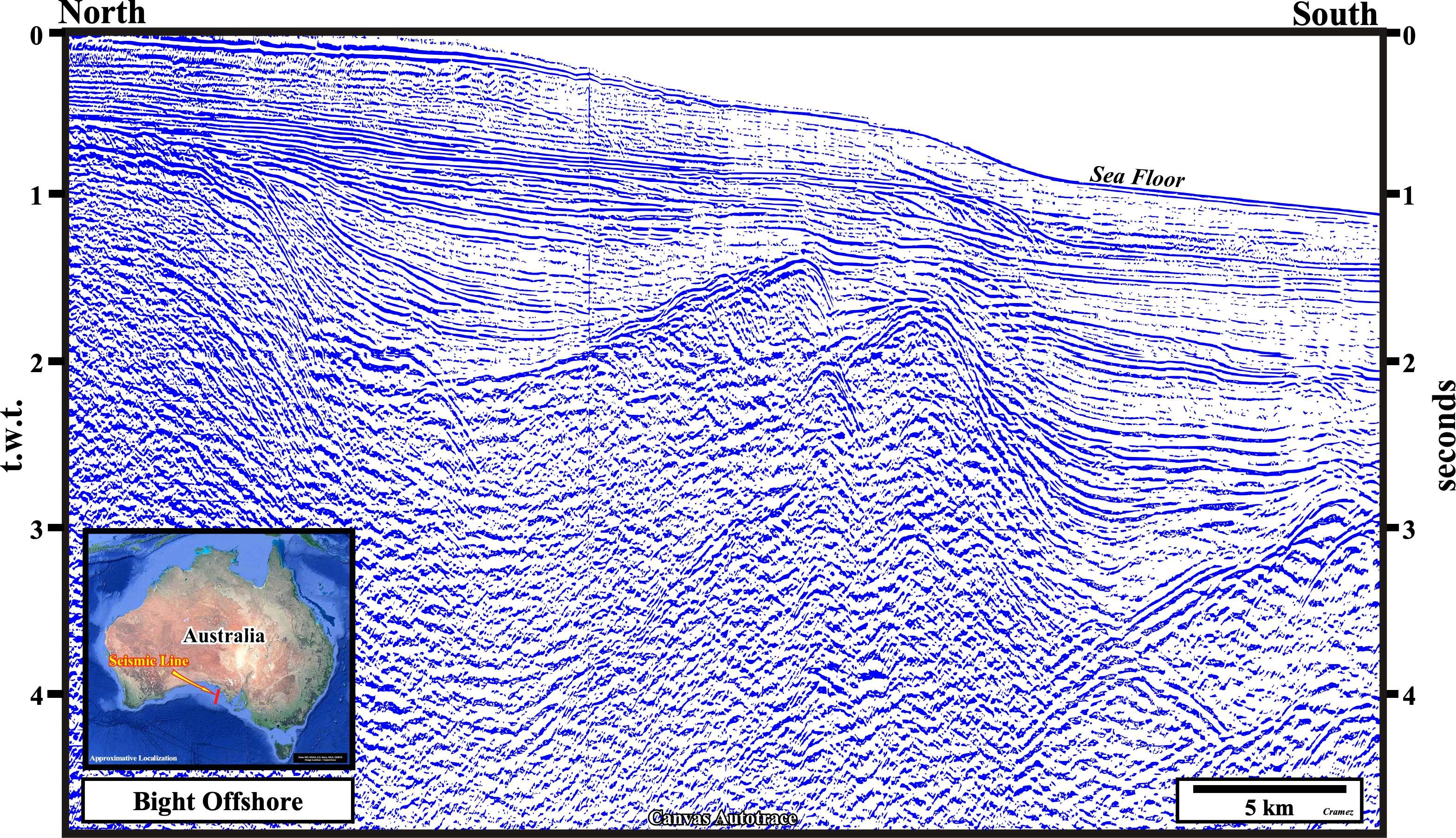
On this Canvas autotrace of a deepwater seismic line, the downlap surface separating the transgressive and regressive stratigraphic phases of the post-Pangea continental encroachment stratigraphic cycle is obvious. In spite of the lengthening (normal faulting) of the sediments during the transgressive phase, the upbuilding and retrogradational geometry, induced by a more or less continuous absolute sea level rise, still is recognized. Similarly, but much more evident, is the progradational geometry of the regressive phase, induced by a gradually absolute sea level fall, which in the whole displaces seaward the basin edge. As illustrated on this autotrace, in generally, we can say, within the regressive phase, the sedimentary regressions, deposited during the periods fall or stability of the relative sea level, are increasingly important and the marine ingressions (relative sea level rises with formation of a shelf), during which there is no deposition, but erosion or ravinement, are increasingly smaller. It is this alternation of increasing important sedimentary regressions and increasingly smaller marine ingressions that creates an overall forestepping geometry.

![]()
![]()
Send E-mails to carlos.cramez@bluewin.ch with comments and suggestions to improve this atlas.
Copyright © 2001 CCramez
Last update:
2022![]()