
Timan/Pechora Offshore

As illustrated on the location map (lower left corner of the plate), this strike schematic geological cross-section of the onshore of the Timan-Pechora geographic basin, which corresponds to a triangular-shaped cratonic area bounded by the Ural Mountains and the Timan Ridge (the northern boundary is shared with the South Barents Sea geographic basin) shows the major tectonic and stratigraphic features. The basement comprises Late Precambrian rift-type basins (filled by thick non-metamorphic sedimentary rocks. The Phanerozoic sedimentary column is slightly deformed in the west and central parts into several broad depressions and more narrow intermediate highs. The eastern part is, strongly, shortened by thrust faults emplaced during the Late Paleozoic in association with development of the Ural fold belt, which induced the formation of Late Paleozoic foredeep basins. Three geological provinces can be considered on this onshore: (i) Foredeep basins ; (ii) Central platform and (iii) NW Izhma depression. The stratigraphy is dominated by Paleozoic platform and shelf-edge carbonates succeeded by Upper Permian to Triassic siliciclastics. The Upper Devonian deep marine shale and limestone are potential source-rocks. which have generated hydrocarbons during Middle Mesozoic. The main rock reservoirs vary in age from the Ordovician to the Triassic, but most are concentrated in Devonian and Permian rocks. Carboniferous structural inversions induced by compressional tectonic regimes (Hercynian and Early Cimmerian orogenies) create a lot of structural and no-structural traps (mainly morphological by juxtaposition).
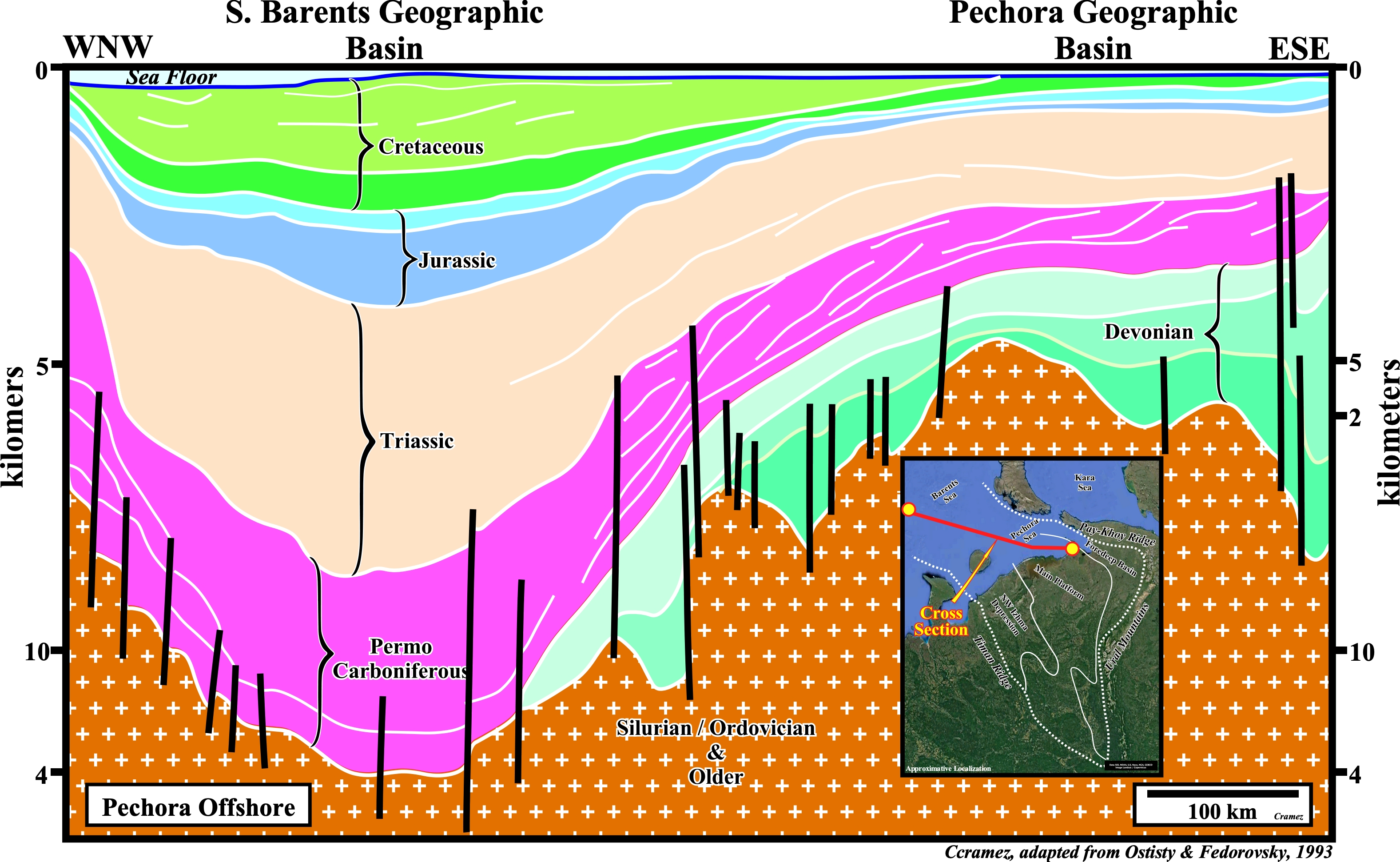
This dip schematic cross-section, which depicts the seaward continuation of the Timan-Pechora geographic basin shows the reactivation, with a reverse movement, of the old normal faults, associated with the development of the Devonian rift-type basins that create huge tectonic inversion. The fault reactivation was concurrent with basaltic volcanism recognized on the seismic lines by the presence of volcanic sills. The Hercynian orogeny (Permian) shortened the sediments creating Ural Mountains and their associated molasse-filled foredeep basins. Early Permian shelf-edge reefs proliferated and a subsequently continuous subsidence began in the Barents Sea geographic Basin to the north. Triassic and later sedimentation became largely continental in the southern regions.

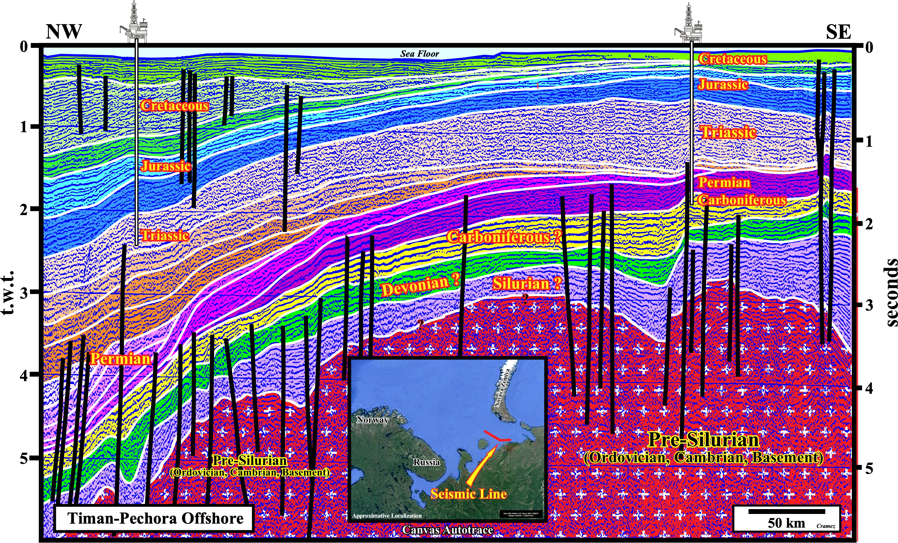
On this Canvas autotrace, the Lower Paleozoic rift-type basins are, easily, recognized, as well as the transitional zone between the Timan-Pechora and the South Barents Sea geographic basin. The progradational geometry of the Permian sedimentary packages seems to be induced by significant relative sea level falls, which are, later fossilized by the onlapping of the Triassic sediments deposited in association with relative sea level rises induced, mainly, by the more or less continuous northward subsidence toward the South Barents Sea geographic basin.

![]()
![]()
Send E-mails to carlos.cramez@bluewin.ch with comments and suggestions to improve this atlas.
Copyright © 2001 CCramez
Last update:
2022
![]()