
Timan/Pechora Offshore

This strike schematic geological cross-section of the onshore of the Timan-Pechora geographic basin, which corresponds to a triangular-shaped cratonic area bounded by the NE-SW trending Ural Mountains and the NW-SE trending Timan Ridge (the northern boundary is shared with the South Barents Sea Geographic basin) shows the major tectonic and stratigraphic features. The basement includes Late Precambrian rift-type basins, which are filled by non-metamorphosed sedimentary rocks, which thickness can reach 10 km. The Phanerozoic sediments filling the basin are slightly deformed in the west and central parts into several broad depressions and more narrow intervening highs. The eastern part is strongly deformed by thrusts emplaced during the Late Paleozoic in association with development of the Ural fold belt, which create Late Paleozoic foredeep basins. Three geological provinces can be considered on this onshore: (i) The foredeep basins ; (ii) The central or main platform and (iii) The NW Izhma depression. The stratigraphy is dominated by Paleozoic platform and shelf-edge carbonates succeeded by Upper Permian to Triassic siliciclastics. Upper Devonian deep marine shale and limestone are potential source rocks. which generate hydrocarbons during Middle Mesozoic. The main reservoirs-rocks range, in age from Ordovician to Triassic but most focused in Devonian and Permian rocks. Carboniferous structural inversions induced by compressional tectonic regimes (Hercynian and Early Cimmerian orogenies) create a lot of structural and no-structural traps (mainly morphological by juxtaposition).

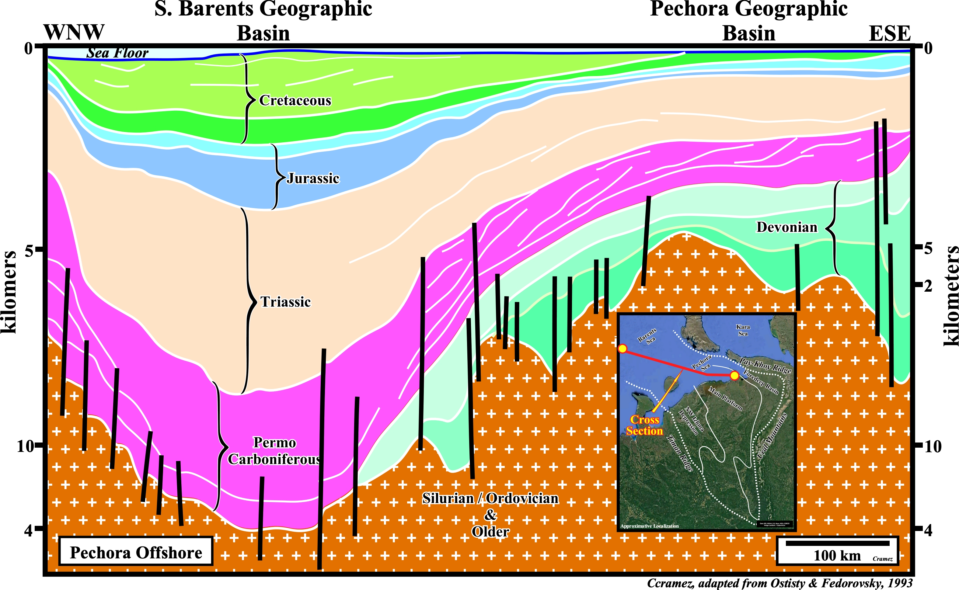
This dip schematic cross-section, which depicts the seaward continuation of the Timan-Pechora geographic basin shows the reactivation, with a reverse movement, of the old normal faults, associated with the development of the Devonian rift-type basins that create huge tectonic inversion. The fault reactivation was concurrent with basaltic volcanism recognized on the seismic lines by the presence of volcanic sills. The Hercynian orogeny (Permian) shortened the sediments creating Ural Mountains and their associated molasse-filled foredeep basins. Early Permian shelf-edge reefs proliferated and a subsequently continuous subsidence began in the Barents Sea geographic Basin to the north. Triassic and later sedimentation became largely continental in the southern regions.
.jpg)
.jpg)
This Canvas autotrace illustrates the limit between the North Pechora offshore and the South Barents Sea geographic basin, which is highlighted by an important faulted zone faulted zone. Notice not only the depressed structure of the continental platform sediments, which seems to be produced by a slow crustal down-warp during several geological periods (syneclises of the Russian geoscientists), but the presence of volcanic sills (colored in red) as well. Such a volcanism seems to be associated with the reactivation of old normal faults as reverse faults during the Permo-Triassic (Early Cimmerian Orogeny). Do not forget that the during the considered pre-Silurian interval, important geological events took place: (i) The Balkanian orogen (Precambrian) ; (ii) The opening of the Uralian ocean (Ordovician / Cambrian) and (iii) The Caledonian orogeny (Ordovician / Silurian), particularly in North Barents Sea.
Send E-mails to carlos.cramez@bluewin.ch with comments and suggestions to improve this atlas.
Copyright © 2001 CCramez
Last update:
2022