
North Norway Offshore
Nordkapp Offshore
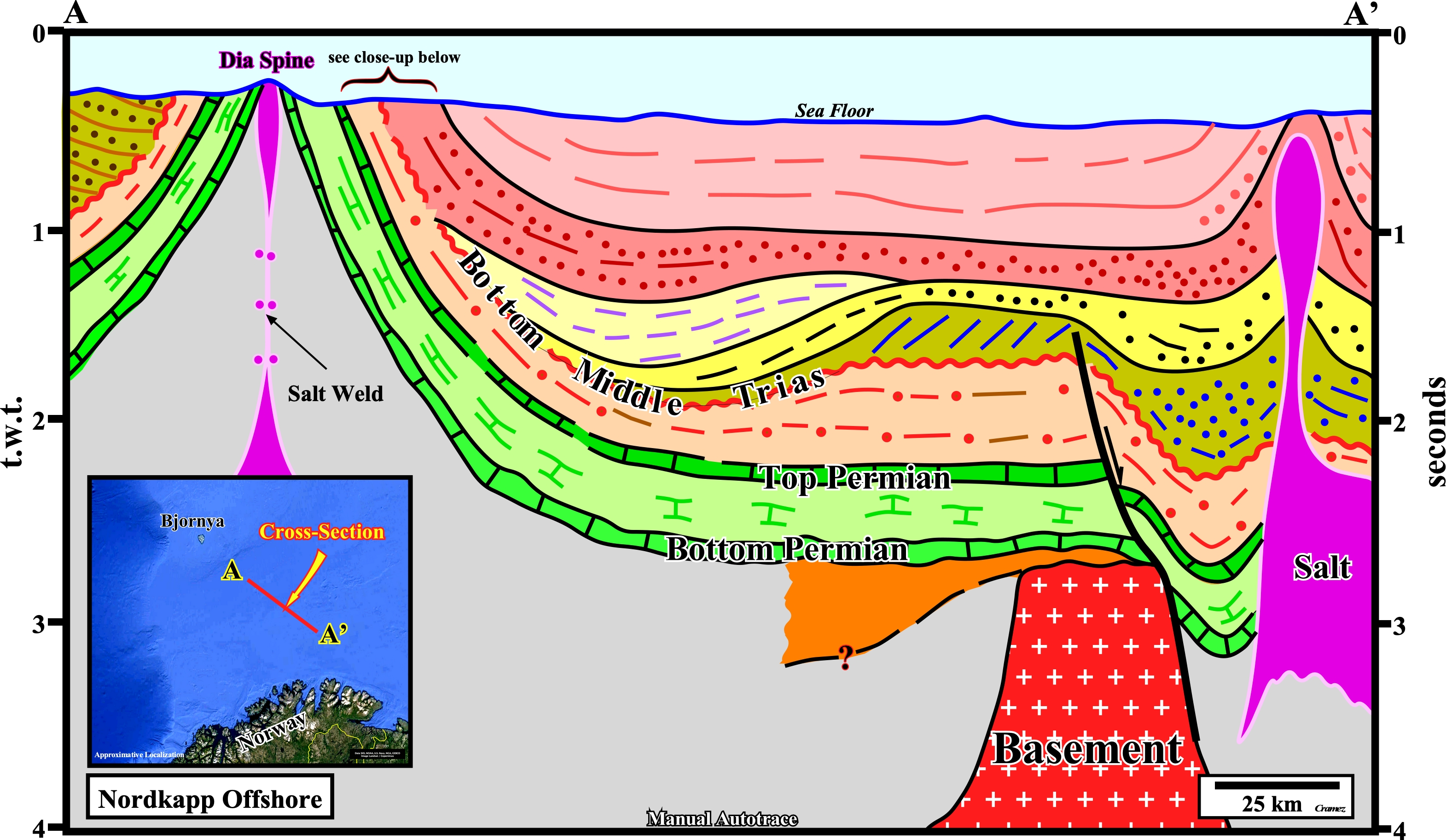
This regional cross-section, based on a tentative geological interpretation of a regional seismic line, suggested the Triassic generating petroleum sub-system has a limited extension. Indeed, it is quite possible that southeastward of the Dia Structure, the Triassic organic rich sediments will be absent. On the right side of the cross-section, the shingled progradations of the Middle Triassic indicate a northward progradation implying a change in the depositional environment with a condensed stratigraphic section northward. The potential Triassic source-rocks drilled in the northern flank of the Dia structure (Salt spine) correspond to sediments deposited in a starved geological conditions (see next autotrace). The southward thickening of the Middle Triassic interval corresponds to a salt-induced depocenter in a platform environment (shelf). The chances of find a Triassic generating petroleum sub-system, there, are low. Contrariwise, as said previously, good Triassic source-rocks have been found on the western flank of the Dia structure, where they seem downlap southward. The geometrical relationships are difficult to determine, inasmuch as they are quite deformed by the salt spine. However, on other seismic lines, the downlap relationship are evident.
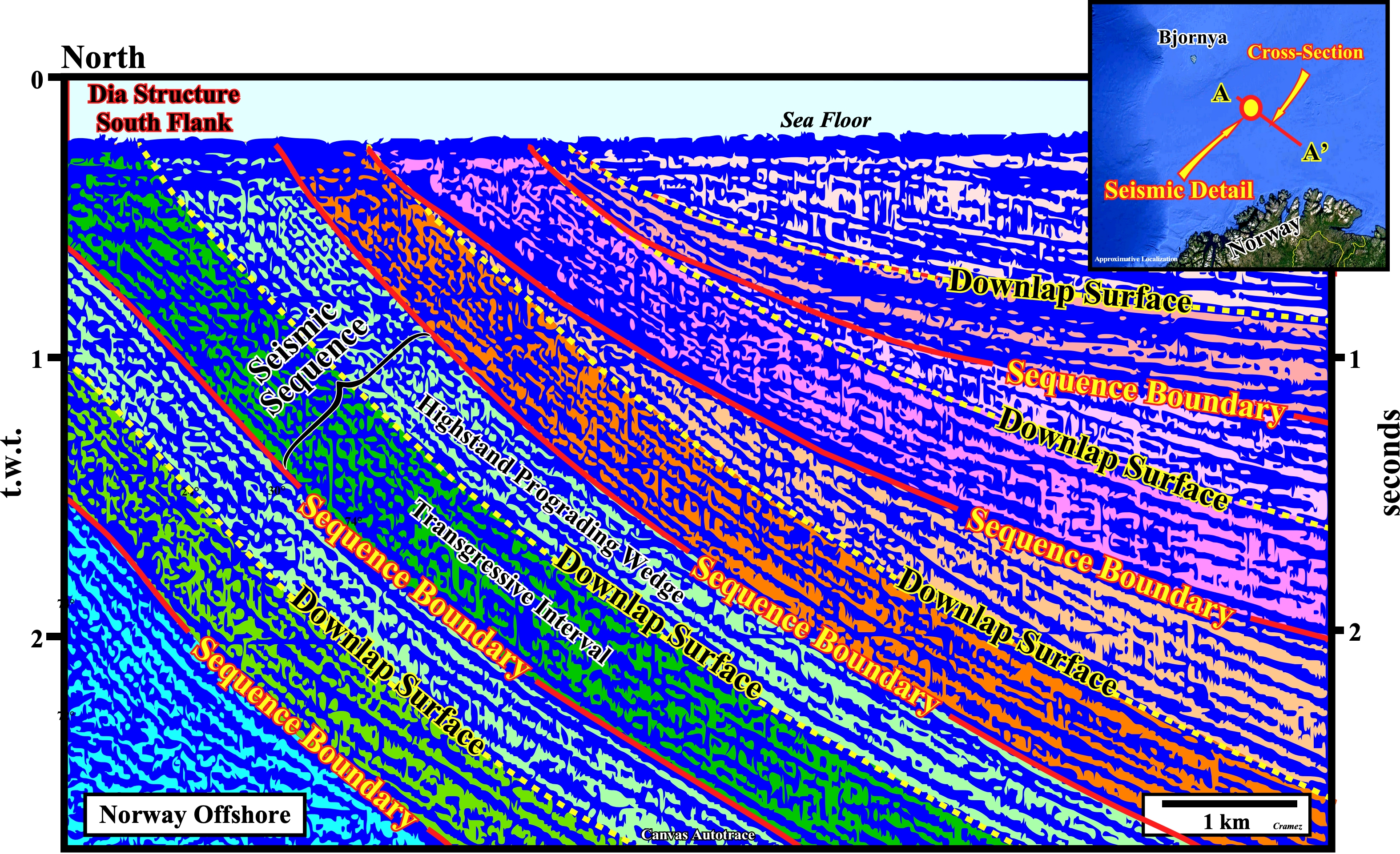
On this Canvas autotrace of a detail of seismic line detail, located in the southern flank of Dia salt spine, several unconformities (relative sea level falls) can be identified. They truncate the underlying sediments and they are fossilized by the onlapping of the overlying strata. In addition, two evident downlap surface are, easily, recognized. On this subject it is important do not forget that unconformity time-gaps may represent: a) Simply prolonged periods of sub-aerial exposures with minimal erosion, often with local valleys or channel down-cuttings ; b) Periods of uplift and major sub-aerial erosion of strata or c) Submarine erosion by turbidite, slump or submarine currents. Submarine erosion induced by gravity or turbidite currents is, generally, relatively local. The associated unconformities with such an erosion are, mainly, located in deep water environments (slope and abyssal plain). These unconformities do not have equivalent in shallow water environments. Uplift and Erosion are characterized by: (i) Onlapping above the unconformity and (ii) Truncation below the unconformity. Valleys or Channels are, also, characterized by : a) Onlapping above the unconformity and b) Truncation below. Very often, geologists confound valley with valley infilling and channel with channel fill. Do not forget a valley is a morphology which corresponds to any low-lying land bordered by higher ground while a valley fill name the more or less unconsolidated sediments, deposited by any agent, partially or completely filling the valley. Similarly, a channel is the bed where a natural body of water flows or may flow, while a channel fill name the sediments deposited in a stream channel especially in an abandoned cutoff channel or where the transporting capacity of the steam is insufficient to remove material supplied to it (Bates & Jackson, in Glossary of Geology, Second Edition, American Geological Institute, 1980).
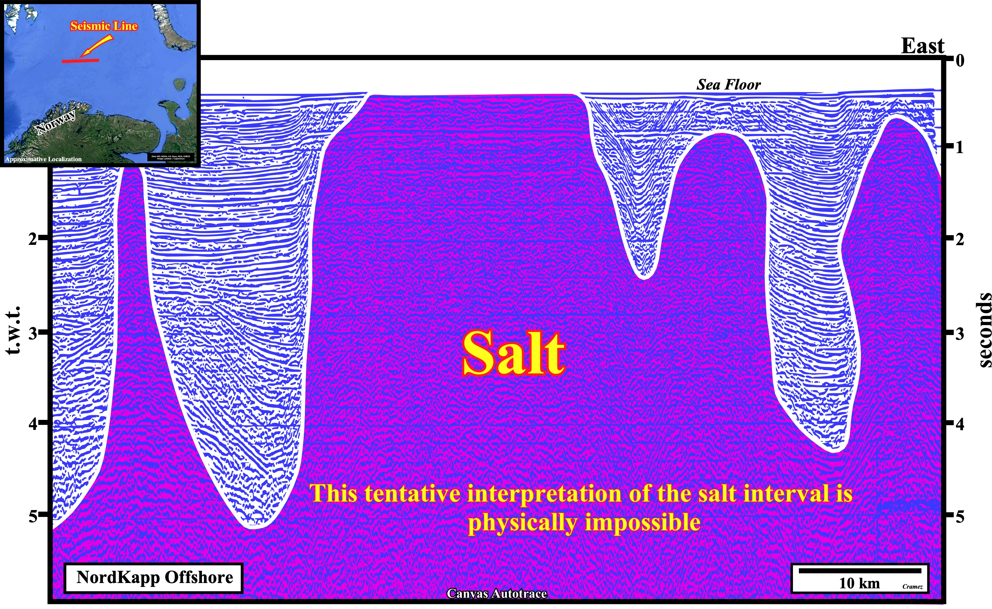
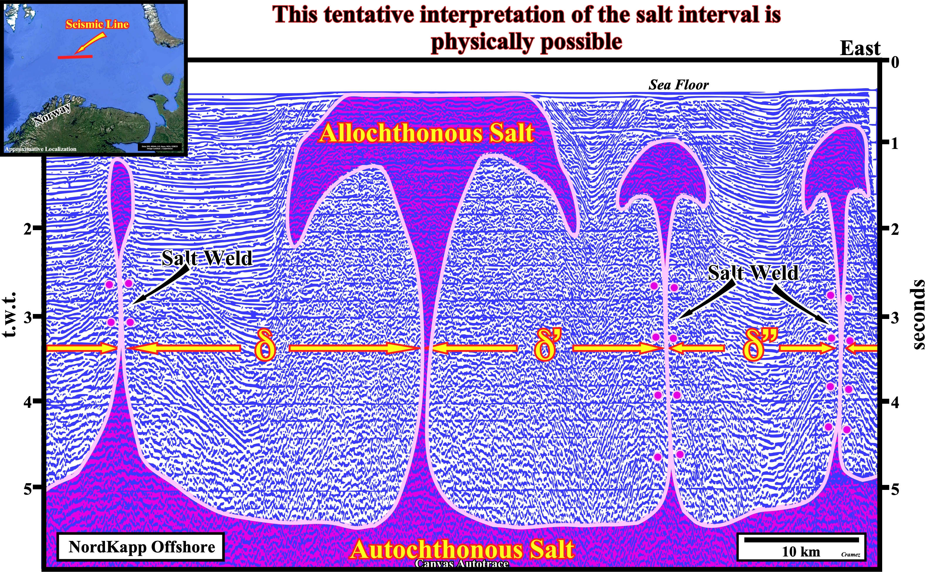
Two different tentative geological interpretations of above Canvas autotrace of a Nordkapp offshore seismic line, in which salt structures are evident, are proposed. The first tentative interpretation (salt domes with more or less vertical flanks) is quite naive. Its is, easy, falsified (refuted) taking into account the velocity of the seismic waves in the evaporites (± 5000 m/s) and in clastic sediments (sands and shales), which ranges between 2500 and 3500 m/s. An approximative time-depth conversion shows the depth of the basin cannot accommodate a so big thickness of the salt layer (a thickness of 5.5 seconds (t.w.t.) of salt corresponds, roughly, to more than 12.500 meters, which is much more than the total thickness of the basin. The second tentative interpretation is more rational (adopting K. Popper's message: "Theory precedes Observation") and much more difficult top falsify. It takes into account the Rayleigh-Taylor Instability, which consider that a dense fluid overburden, having negligible yield strength, sinks into a less dense fluid salt layer, displacing it upward, i.e., the interface between a layer of viscous fluid of uniform density (sediments) overlying a compositionally less-dense layer (salt) is unstable and small perturbations in the horizontal interface become amplified at a rate, represented by an eigenvalue (the special value variable parameter for which the solution of an equation is nontrivial) that depends on the thickness, density, and viscosity of every layer, size of initial perturbation, and time elapse. Making a long history shortened, we can say, the salt density is, more or less, constant in depth (salt is not compactable with depth) an upper allochthonous salt layer is formed, which, generally, is connected to the autochthonous salt layer by salt welds (see next autotraces), as illustrated above, where δ represents the distance between the initial small perturbations at th top of the salt layer.
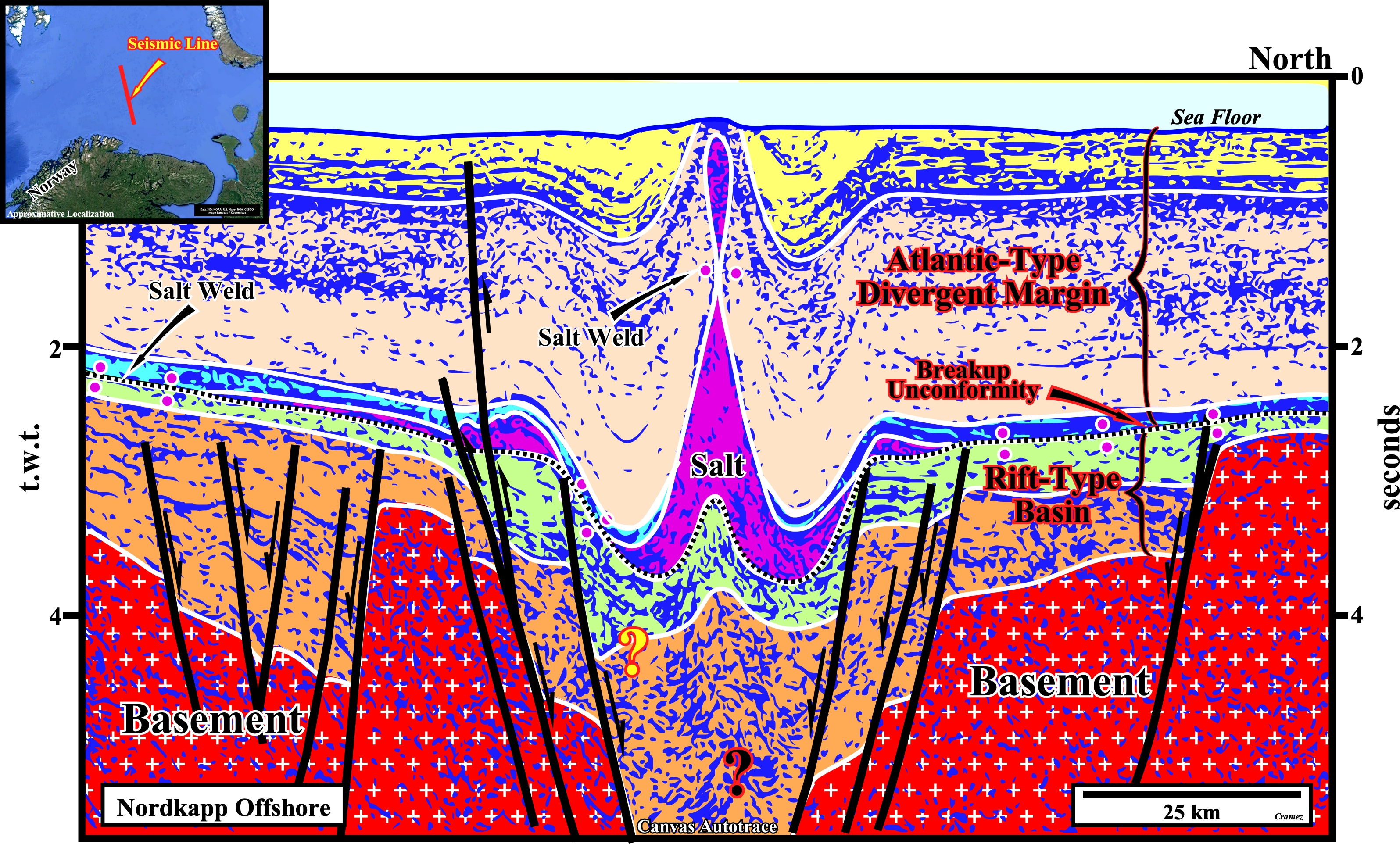
Taking into account the conjectures advanced on previous Canvas autotraces (picking of salt boundaries), this tentative geological interpretation of an autotrace of a regional seismic line of the Nordkapp geographic basin seems difficult to falsify, particularly, the picking of the salt interval, which, in this particular example, is quite obvious. In fact, the salt welds in the autochthonous salt layer as the salt weld in the allochthonous salt layer are quite easy to pick, what is not the case in the next Canvas autotrace. On the other hand, the recognition of the breakup unconformity, that can coincide, locally, with a salt weld, between the rift-type basins and the Atlantic-type divergent margin is not very difficult.
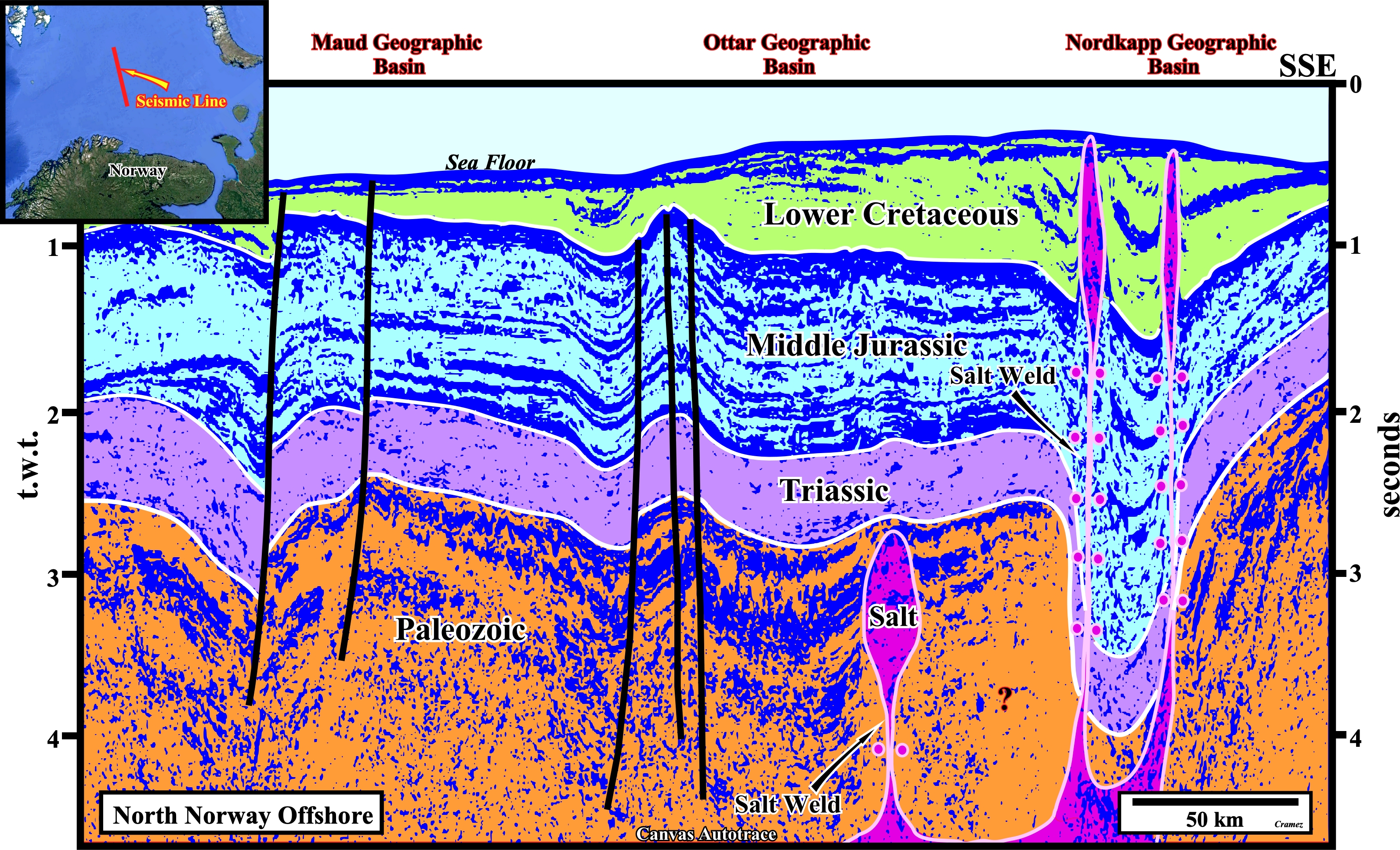
On this tentative geological interpretation, particularly, on the salt picking, seismic interpreters, generally, geologists because they are supposed to know what they are looking for on the seismic lines, need to impose the theoretical knowledge and propose vertical salt welds between the autochthonous and allochthonous salt layers avoiding to pick salt domes with vertical flanks, i.e. salt domes with a cylindric geometry which do not resist to s simple time depth-conversion test. In my professional carrier, I always noticed that in areas of salt deposition, even geologists with a lot of experience propose, always, too much salt on their interpretations.

![]()
![]()
Send E-mails to carlos.cramez@bluewin.ch with comments and suggestions to improve this atlas.
Copyright © 2001 CCramez
Last update:
2022
![]()