France Offshore
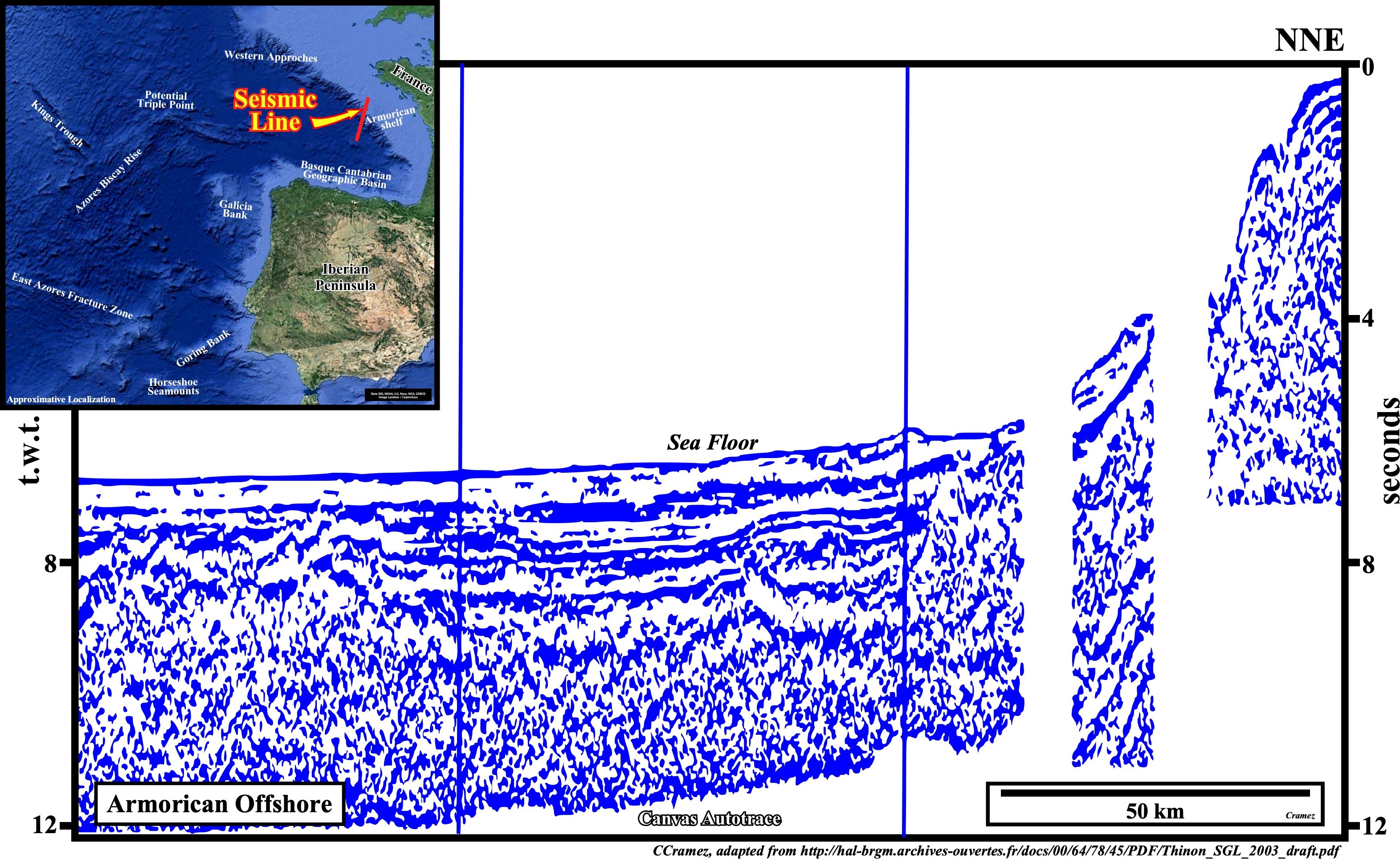
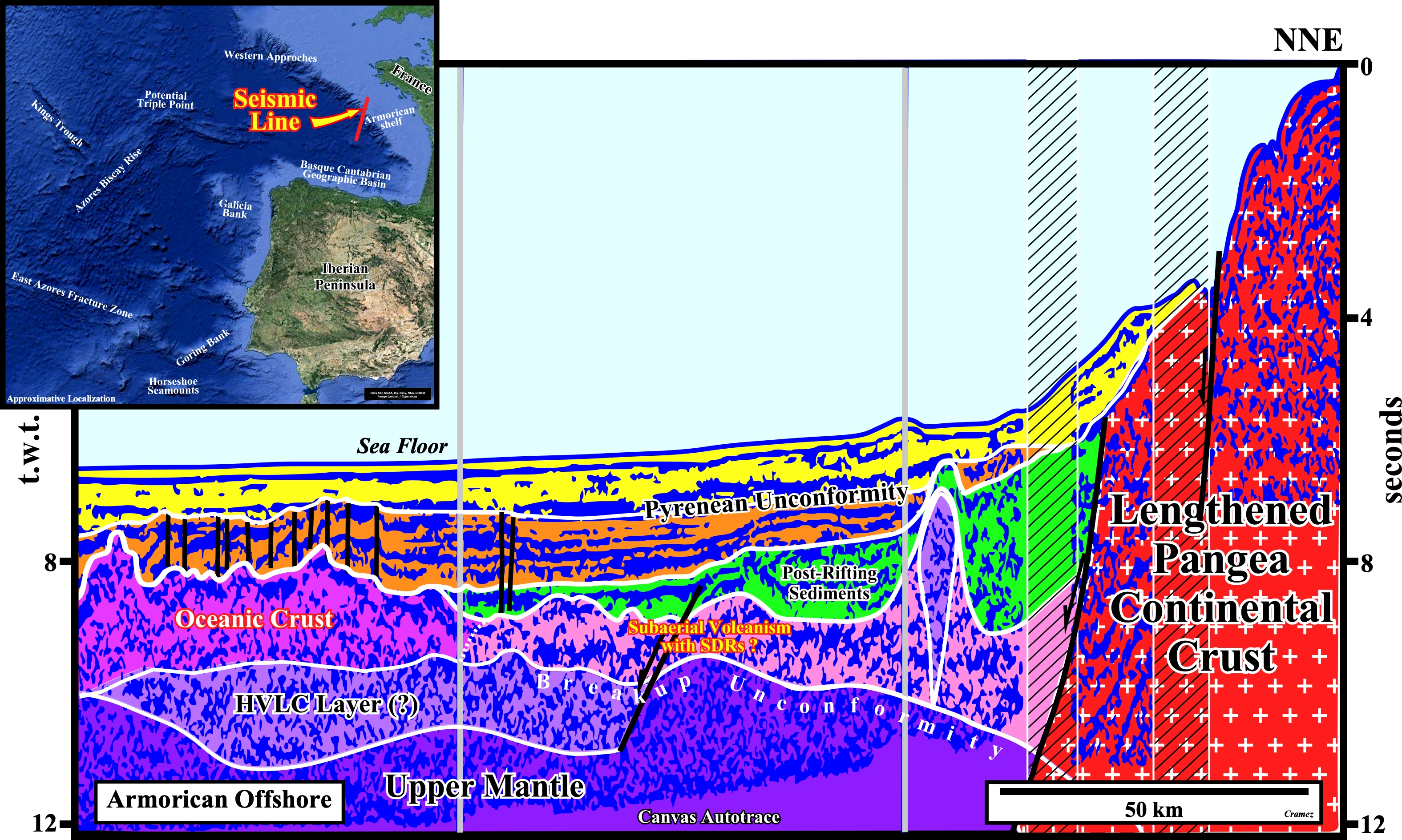
Armorican Offshore
To understand the North Iberian Peninsula Offshore and Armorican offshore we must take into account: (i) The East Azores Fracture Zone ; (ii) The Azores Biscay Rise ; (iii) The Galicia Bank ; (iv) Middle North Atlantic Ridge ; (v) The position of the Magnetic Anomalies ; (vi) the Goring Bank and (vii) the Extensional Zone between the Galicia Bank and the Armorican offshores, which, strongly, suggest this area does not correspond to a typically Atlantic-type divergent margin. Geological reconstructions at the magnetic anomaly M0, i.e., around 118 Ma, suggest, the onset of the sea-floor spreading, in Galicia Bank was, more or less, adjacent to Flemish Cap. Similarly, Iberian and Tagus Abyssal Plains seem, also, to match with the North and South Terra Nova geographic basins. A major fracture zone existed, already, between South Newfoundland and South Iberia. A triple point, northward of Flemish Cap and Galicia bank could be predicted. The extension between M0 and M25 underline the motion of the lithospheric plates and emphasized the geological particularities of Newfoundland and West Iberia offshores when compared with the conventional Atlantic offshores. In other words, in the Neo-Tethys Sea, northward of Iberia and the triple point, between Galicia Bank and Flemish Cap, the presence of SDRs is likely.
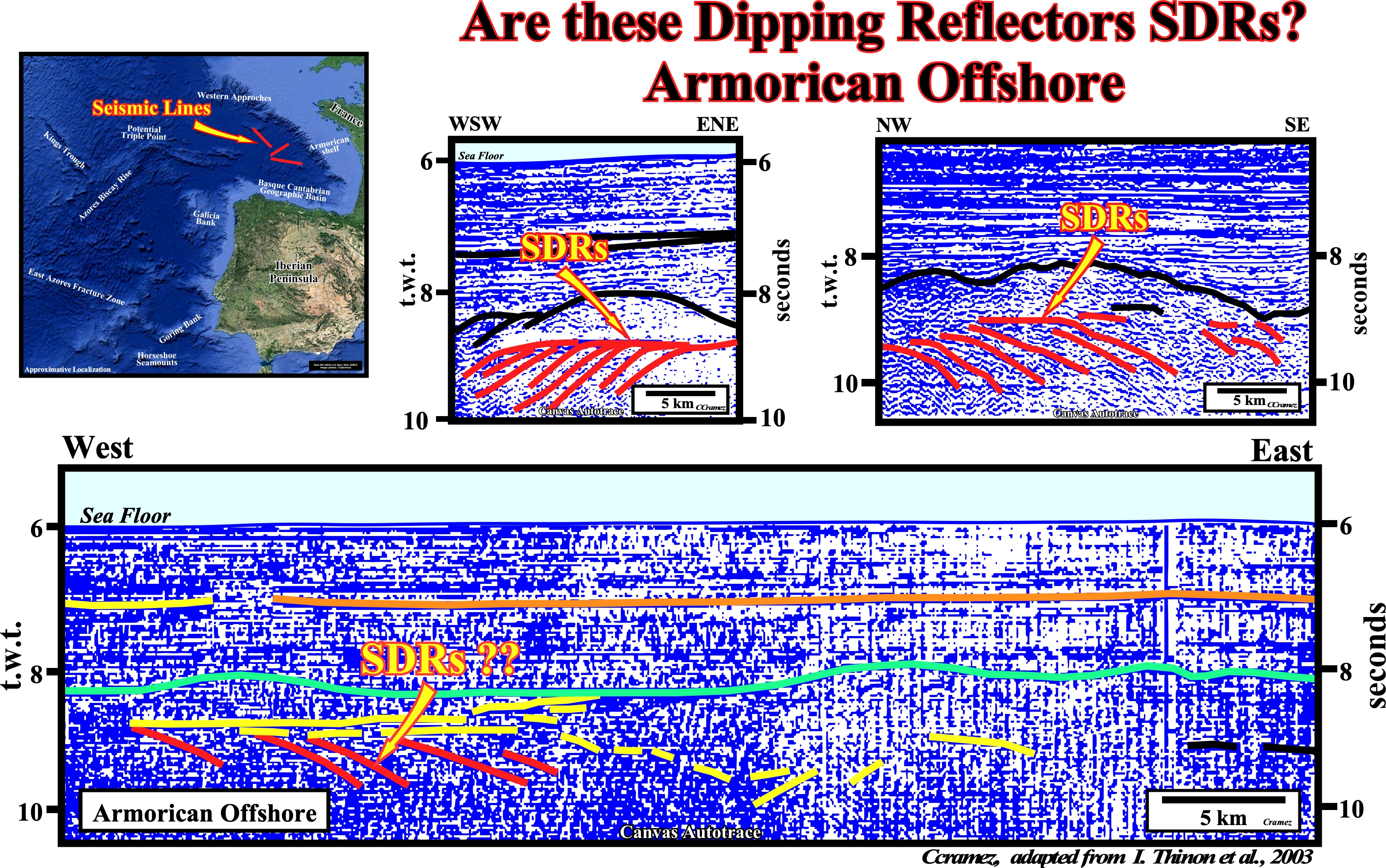
This Canvas autotrace of a regional composite seismic line of the Armorican offshore illustrates the presence of probable sub-aerial volcanism between the lengthened Pangea continental crust, in which potential rift-type basins developed, and the oceanic crust. In the northern part of the autotrace, an younger volcanic intrusion, sharply, cut the sub-aerial volcanism and the post-rifting sediments (green interval). Details of different seismic lines shot in this area, exhibit nice seaward dipping reflectors, which can be interpreted as lava-flows ( see next figure ).
Seems to us that the above dipping reflectors can be interpreted, with a certain probability as sub-aerial lava-flows, particularly those of the upper seismic detains in which they, clearly, dip seaward what is less evident on the lower seismic line. On this subject, it is important to remind (i) SDRs were first recognized on the continental margin of the Norwegian Sea (Hinz and Weber, 1976; Mutter et al., 1982; Roberts et al., 1984a,b) ; (ii) SDRs represent sub-aerial basalt-flows erupted close to sea level ; (iii) SDR sequences are immense, as much as 20 km thick, their width varies from tens to hundreds of kilometers ; (iii) They form, generally, a magnetically subdued band, which results from extrusion within a single polarity interval or from stacking of flood basalts ; (iv) Their seismic character of SDRs varies greatly ; (v) Variations in continuity, dip, amplitude, reflection pattern, and thickness are controlled by the volume and rate of magmatic production, the volcanic environment (vent geometry, relation to sea level, etc.), any syn-volcanic and post-volcanic deformation, and rate and amount of subsidence (Eldholm et al., 1995) ; (vi) Nevertheless, SDRs have several distinctive features: a) seaward-dipping reflectors are convex up ; b) dips steepen seaward from subhorizontal nearest the surface to 9–30° at their base (Roberts et al., 1984a ,b) ; c) Individual reflectors can be traced for up to 11 km down-dip ; d) SDR flows average only 6 m thick, which is too thin to create individual reflectors (Barton and White, 1997) ; d) SDRs may represent a complex interference pattern between stacks of thin basalt flows and some thick individual flows (Eldholm et al., 1995) ; e) Inter-bedded volcano-clastic sediments and tuffs and weathered flow contacts provide further impedance contrasts (Roberts et al., 1984a,b) ; f) On strike-parallel profiles, reflectors are, typically, subhorizontal (Barton and White, 1997), except where complicated by volcanoes or oblique fissures ; (vii) Sedimentary reflectors conformably overlie the SDR basement ; (viii) SDRs disappear downward into noisy reflections, where the geology is obscure. ; (ix) SDRs partly overlie stretched continental crust (Skogseid and Eldholm, 1995), but deep, rotated fault blocks are, rarely, imaged because masses of melt weaken and remobilize the crust ; (ix) Landward, SDRs onlap continental crust, indicating that their source was seaward ; (x) The landward SDR pile was emplaced above what is interpreted to be stretched and intruded continental crust, probably before breakup ; (xi) The oceanward SDR belt separates stretched continental crust and true oceanic crust and was probably emplaced when sub-aerial sea-floor spreading began ; Oceanic crust is typically about 7 km thick (White and McKenzie, 1995) and has a hummocky surface, including steep-sided volcanic mounds (Eldholm and Grue, 1994). Oceanic crust is opaque, containing only short or chaotic reflectors obscured by diffractions.