Black Sea
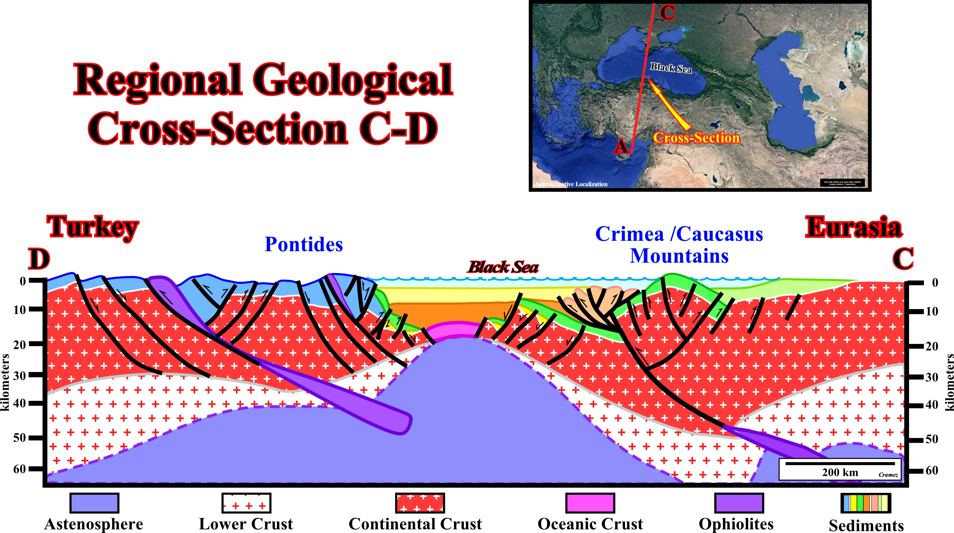
This regional geological cross-section through Black Sea illustrates the Paleo-Tethys suture, which was broken and displaced by the oceanization associated with the formation of Black Sea basin, and the Neo-Tethys suture (see Page 49). The Proto-Tethys suture, i.e. the westward continuation of the Buzachi high is, probably, northward of the cross-section, or does not exist (the Buzachi micro-continent could be very restricted). The Black Sea geographic basin is, here, interpreted as a restricted anoxic Mediterranean-type basin, where organic rich Oligocene/Miocene deep-water sediments were deposited (Maykop formation). The loading of the thrust folds associated with the Crimea and Caucasus Mountains, strongly, tilted northward, in the northern part of the basin. Huge tilted blocks were created by reactivation of the preexistent normal faults, developed during the extensional tectonic regimes. Admittedly, the crestal part of one of these large tilted blocks (Shatsky Rigde) forms a quite large potential trap for hydrocarbons.
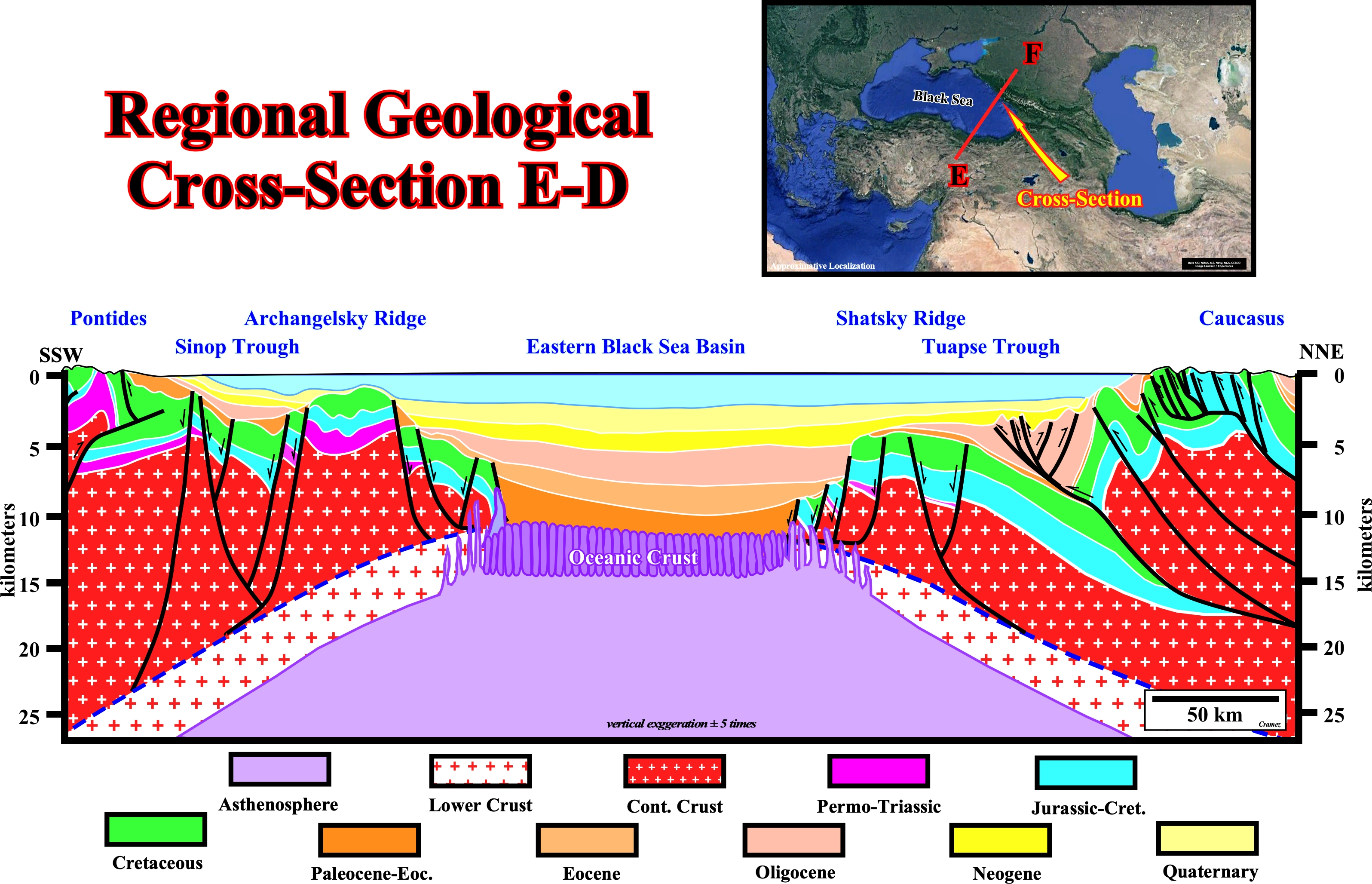
This NE SW geological cross-section through western part of the the Black Sea geographic basin depicts, from north to south, the following major morphological features : (i) The Caucasus mountains ; (ii) The Tuapse through ; (iii) The Shat sky Ridge ; (iv) The Eastern Black Geographic Sea Basin ; (v) The Archangelsky Ridge ; (vi) Sinop Through and (vii) The Pontides. In this interpretation the Black Sea basin is considered as a Mediterranean type basin, since an oceanization is considered to take place as a consequence of the lengthening of the continental crust. The fold-belt basin, developed in the northern part, overload the Mesozoic Pannonian basin, tilting northward the faulted blocks creating large traps by juxtaposition, as for instance those associated with the Shazski Ridge (see later). According to the classification of the sedimentary basins proposed by Bally and Snelson (1980), as illustrated in the cross-section the Black Sea geographic basin is considered as a post-Mesozoic Mediterranean-type basin. In other words, I hypothesized, or I guessed, that in the central part of the Black Sea, the infrastructure of the basin is the oceanic crust. The breakup of the continental crust (basement + old sediments), as illustrated above, is supposed to have taken place when the lithosphere reached a thickness of more or less 10-20 km. Actually: a) In an extensional tectonic regime, when the β extension ratio reaches ± 3-4, the continental crust cannot anymore be lengthened by normal faulting and it breaks (Seaver, 1998) ; b) The breakup of the continental crust is just a simple consequence of volcanic intrusions of the upper mantle ; c) When the continental crust starts to be lengthened, it becomes also thinner (uplift of isotherm 1250° C) allowing intrusions of mantle volcanic material (dykes) ; d) The continuation of lengthening and the subsequent thinning (cause or effect ?) favors volcanic intrusions and so, the crust become highly intruded. Finally, the mantle material with creation of oceanic crust splits the continental crust ; e) On seismic lines, between the oceanic crust (hummocky reflections) and the continental crust, one can find an intermediate highly intruded crust. In non-migrated lines, the highly intruded crust is characterized by diffractions. In migrated lines, the sediments overlying the intruded crust are undulated, that is to say, the underling volcanic dykes lengthen them. Pelagic and deep-water sediments filled the restricted Cenozoic Mediterranean-type basin : 1) The accommodation, created by the lengthening and the oceanization, was not compensated by the terrigeneous influx. and an important water-depth was created ; 2) In the lower section of the basin, thick organic rich sediments were deposited and preserved ; 3) The burial of these potential source rocks was big enough to their organic matter reach maturation and they form a very good generating petroleum sub-system (Maykop formation or equivalent) ; 4) The infrastructure of the Mediterranean-type basin is whether the oceanic crust or the underlying Mesozoic Pannonian sediments, which facies (lithology) is mainly carbonate (with associated marl and shales) ; 5) They form a very good entrapment-migration petroleum sub-system, particularly when they are tilted northward by the loading of the Caucasus thrusts. Such a tilting is particularly visible in the NE part of the basin, where the Shatsky Ridge is by far the more obvious tilted block. It seems to be enveloped by the mature organic rich sediments, that is to say, the major generating petroleum sub-system.
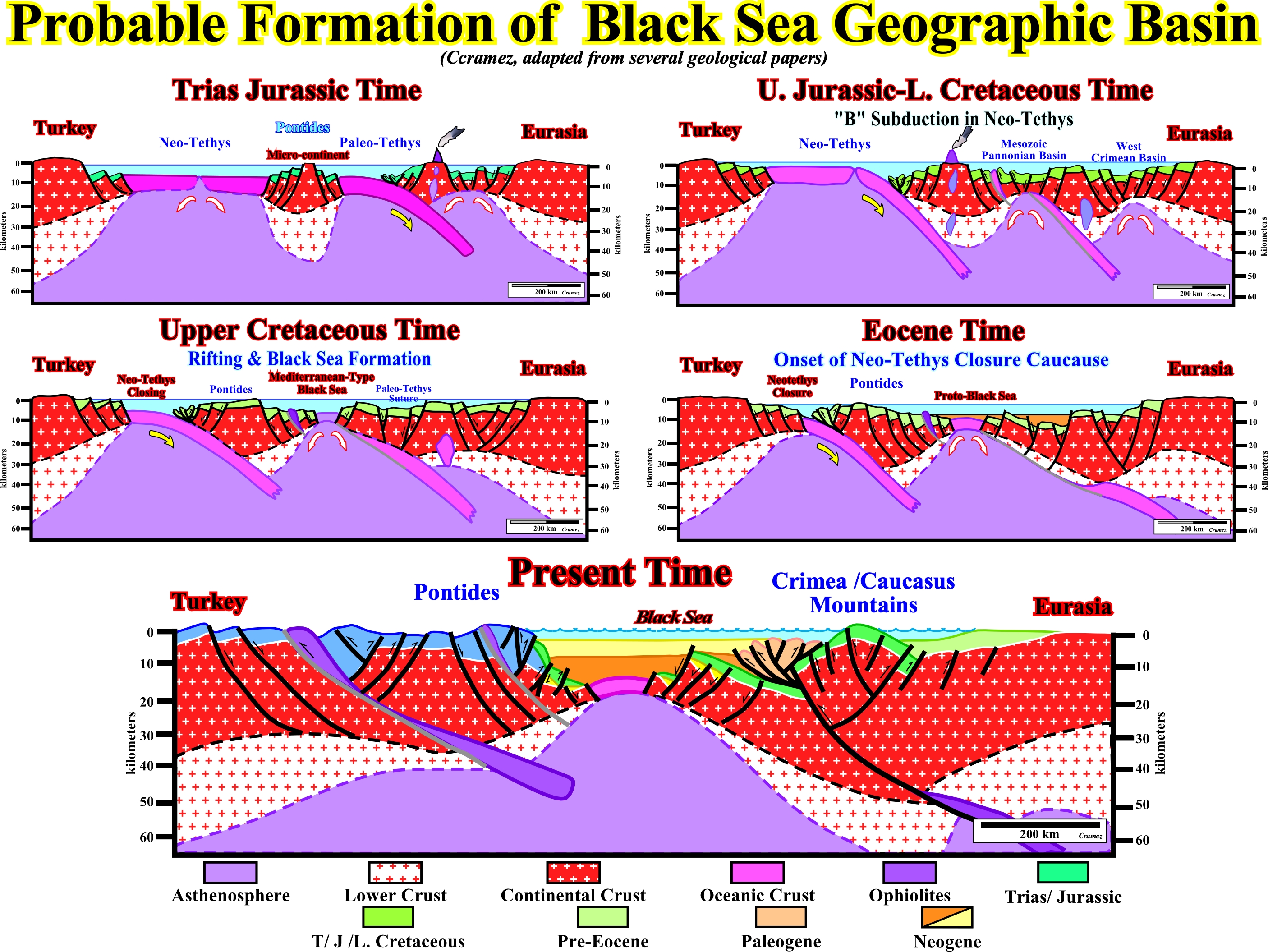
A probable geological evolution, from Triassic to Present, is schematically is depicted above : (i) When the Pangaea supercontinent started to be lengthened (Trias - Lower Jurassic), a micro-continent (Pontides) existed between Turkey and Eurasia ; this micro-continent separated the Neo-Tethys, in the south, from the Paleo-Tethys, in the north. Both seas had a volcanic bottom (oceanic crust) ; the Neo-Tethys was limited by two continental divergent margins separated by an active mid-oceanic ridge ; contrariwise, the Paleo-Tethys was limited between a divergent (south) and a convergent (north) margin ; in fact, the old mid-oceanic ridge of the Paleo-Tethys was already subducted along the Benioff zone of the south Eurasia ; the subduction of the oceanic crust of the Paleo-Tethys created an active volcanic arc, a forearc basin and a backarc associated. (ii) The persistence of the subduction of the Paleo-Tethys oceanic crust, under the Eurasia, progressively closed the Paleo-Tethys sea and finally, in Middle Jurassic time, the micro-continent (Pontides) collided with the Eurasia creating a fold-belt ; both continental crusts (basement and sediments) were strongly shortened and uplifted ; the volcanic arc became inactive, as well as the extension in the backarc ; the sediments of the Triassic / Lower Jurassic forearc and backarc basins were strongly shortened ; relics of the pristine Paleo-Tethys oceanic crust formed a long an deep ophiolitic trend. (iii) After the collision between the micro-continent (Pontides) and the Eurasia, i.e., after the closure of the Paleo-Tethys sea, the oceanic crust of the north part of Neo-Tethys became too cold and too dense ; accordingly, it started to plunge under the Eurasia creating a Benioff zone and the combined convergent margin; The subduction of the oceanic crust also created an active volcanic arc in the Eurasia continent ; mantle convection currents, induced by the subduction of the cold and dense oceanic crust of the Neo-Tethys, generated an important extension (lengthening) and subsidence, in the southern Middle Jurassic fold belt of Eurasia, creating a Mesozoic Pannonian basin ; such an extension broke up and displaced the ophiolotic trend of the Paleo-Tethys suture ; the extension in the northern part (West Crimean basin), i.e., northward of the old slab of the Paleo-Tethys oceanic crust was probably less important than the one that induced the Mesozoic Pannonian basin. (iv) The continuation of the subduction of the Neo-Tethys oceanic plate had several important geological consequences : 1) The mid-oceanic ridge was gobbled down by the Benioff zone ; 2) the closing of the Neo-Tethys sea became eminent ; 3) he extension in the Mesozoic Pannonian thinned the continental, which became highly intrude and broke up, creating a Mediterranean-type basin ; 4) Oceanization and seafloor spreading took place in Black Sea basin ; 5) The ophiolites of the Paleo-Tethys suture became completely disconnected and largely displaced of the original volcanic slab ; 6) The rate of subsidence of the new Mediterranean-type basin was not balanced by the terrigeneous influx, so, the water depth became very extremely important and deep-water sedimentation took place. (v) At Eocene time, the eastern part of Neo-Tethys sea was almost completely closed (Transcaucasus) ; the Caucasus starts to uplift ; nevertheless, the north Anatolian fault stayed inactive until the Upper Miocene ; the filling of the Mediterranean-type basin was very slow and the water depth very high ; the sediments are mainly limestones ; however, singular depositional systems took place near the margins of the basin, were the clastic terrigeneous influx was predominant ; during Oligocene and Miocene time, the depositional systems became very shaly and restricted favoring the deposition and the preservation of organic matter, particularly in the Oligocene-Lower Miocene. (vi) Presently, the geological configuration is quite different from that of the Eocene time ; actually, from Eocene to Upper Miocene/Pliocene, a lot of events took place: a) the completely closure of the Neo-Tethys sea, with subsequent collision between the Turkish and the south Black Sea micro-plates ; b) the formation of an Upper Neogene suture with the rising a new folded belt, where the ophiliotes are just the relics of the old Neo-Tethys oceanic crust ; c) the Crimean and Caucasus mountains rose progressively ; d) in so far as the southern Cacucasus foredeep basin migrated southward younger sediments were progressively shortening ; e) The loading of the thrust faults tilted northward the faulted-blocks of the sediments of the Mediterranean and Pannonian-type basin creating huge morphological by juxtaposition traps as those associated with the Shatsky ridge, which is just la large northward tilted faulted-block.
![]()
![]()
Send E-mails to carlos.cramez@bluewin.ch with comments and suggestions to improve this atlas.
Copyright © 2001 CCramez
Last update:
2022
![]()