At the bottom of several slides, you will find some comments, which, I guess, help you to better understand the scientific methodology adopted by the majority of the geoscientists in charge of the tentative geological interpretations of the seismic lines. As you know, there are not true or bad geological interpretations, but just falsifiable (scientific) and metaphysic tentative interpretations (metaphysical means here beyond physics, i.e., beyond all possible scientific experiments).

Science is characterized by a particular methodology that some geoscientists abbreviate as PHT (Problem, Hypothesis, Test). When a geoscientist has a problem, he advances an a priori hypothesis and then he tests it (criticize it). In a scientific approach, the geoscientist tries to falsify the advanced hypothesis with the available data and not to validate or verify it. The data can just corroborate or validate an hypothesis, but never verify it. Epistemologically, that is to say, in the philosophical theory of knowledge, corroboration, validation and verification are not synonyms. A given data can corroborate an a priori hypothesis, but additional data refute it. All geological a priori hypotheses must be falsifiable (scientific) and not pseudoscientific or metaphysic (not falsifiable). The sentence "All antiforms are structural traps" is a scientific statement since it can be submitted to a falsification test, but "All anticlines are antiforms" is a pseudoscientific statement because there is no way to test it.

Naive inductive geological interpretations of seismic lines are performed by geoscientists who think that knowledge comes only from observation and that a priori knowledge can only corrupt his observations. Contrariwise to K. Popper, they think that Observation precedes Theory. They are not interested to know from where the seismic data comes to avoid geological contamination of their observations, which they think must be theory-unladen. Picking, in continuity, of the more evident seismic marks, they arrive to advance an empirical hypothesis that they try to validate with additional data. They do not try to refute the hypothesis, but, on the contrary the try to justify it, looking just for the data which verify or validate their hypothesis. This kind of knowledge (empirical or sense knowledge) can only ever be a matter of opinion or belief because it is subjective and always changing. In a hypothetical-deductive interpretation, the geoscientist in charge of the interpretation try to recognize on the seismic lines the major geological events characterizing the area from where the data comes. In such interpretation approach, the geoscientist must have a perfect geological knowledge of the area, since Theory precedes Observation, that is to say, all observation are theory laden. On the other hand, using available geological data he tries to falsified (criticize) the a priori theory and not to verify it. If he can be able to falsify the a priori theory or geologic tentative interpretation he will be oblige to advance a new theory or to propose a new tentative interpretation, which he try to falsify again and so on. Geological interpretation improvement comes from trial and errors, i.e., from criticism and not to verificationism.
When a geoscientist says that "in a given basin there are not structural traps", everybody has the possibility to test such a statement looking at a seismic line shot in the basin and see if the sediments have been shortened or not. If the sediments have been lengthened, theoretically speaking, it is quite evident that the probability of finding structural traps (traps with a four way dips closure) is quite small, see impossible. Pseudoscientific sentences as "in this basins there structural traps but their highlighting is quite difficult " are used by incompetent and careerist geoscientists that refuse to make mistakes and want always be right. I remember certain of my old colleagues recommend me to be more carefully in the writing of my reports to the boss: "in the first pages you write your opinion, but then, you must protect yourself wrinting the opposite so nobody can never falsify your hipotheses".

I never forgot the first lesson of philosophy of sciences. The professor arrived to the classroom, said good morning to everybody and seat down. Then, he said to us, please observe and started to read a book. After few long minutes, one of my colleagues, probably the most courageous, get up and said : "Sorry professor, but I do not understand, what should I observe? The professor jump from its chair and said : "Obviously my friend, you must know what you want to observe, Theory precedes Observation, or, in other words, all observation is theory laden". In the geological interpretation of the seismic lines is the same thing. If the geoscientist in charge of the interpretation does not know, a priori, what is a delta he never recognize it on a seismic line even if he spends hour or days looking at the seismic line. In addition, if he does not the difference between a delta and a deltaic construction, he can easily take a continental slope as a prodelta and vice-versa. Generally, in a naive inductive interpretation, the geoscientist does not use the classic geological terminology. He uses the every day language and speaks in red marker, yellow bodies or Mickey mouse structure and so on.
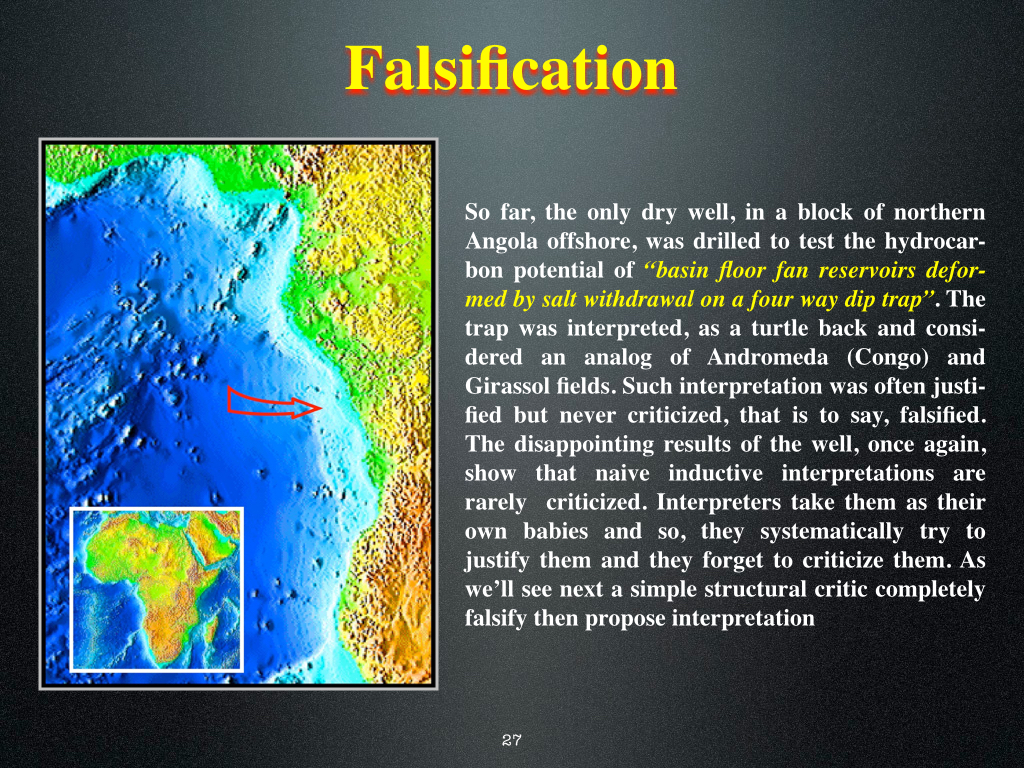
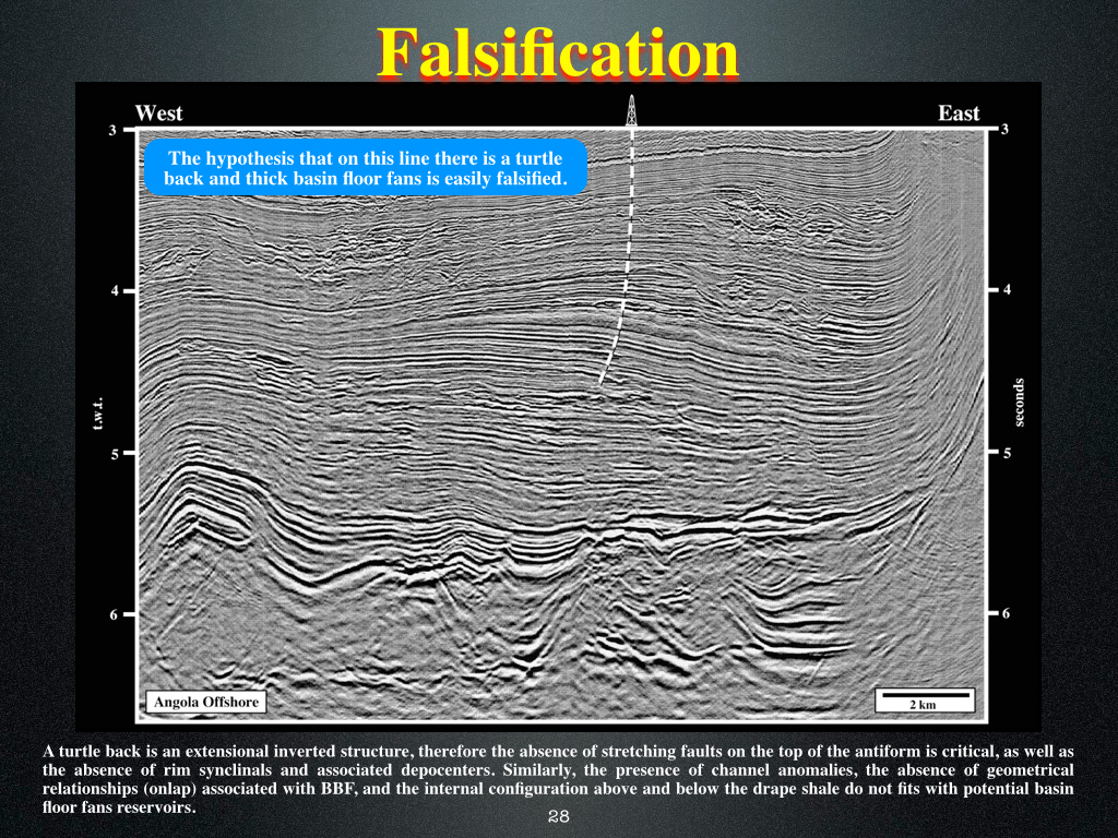
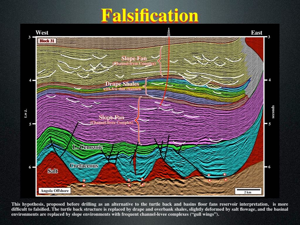
Serendipity (good luck in making unexpected and fortunated discoveries) is frequent in oil exploration. The most famous examples are Girassol field in Angola offshore and Marlin field in Brazil offshore. In both cases, the first exploration well targeted a quite large Mesozoic salt induced turtle-back structure. However, during the drilling of the Tertiary sediments overlying the turtle-back, to everyone's surprise, the well put in evidence large oil accumulations in association with turbiditic deposition systems, which had not been taken into account by any geoscientists before the well. On the hand, if a geoscientist guess that, in certain basin, slope fans can be present at the bottom of the continental slope, he is going to look for "gully wings" (channel-leveed complexes) and, probably, he is going to found them above basin floor fans. Do not forget that seismic data is shot, mainly, to test a geological or petroleum conjecture advanced and not to allow the geoscientists to advance a conjecture, what is quite often forgot by the geoscientists.
The knowledge of the geological context is fundamental to understand the observations made by a geoscientist on a seismic line or in the field. When a geoscientist carrying out a naive inductive interpretation, he disdains the regional geological context, to not be influenced by it, as he says. If he picks a more or less monticular anomaly that, generally, he colored it in yellow or in green, without propose any hypothesis or lithological prediction, calling it "yellow body. A geoscientist knowing the regional geological context of the area where the seismic line was shot (divergent continental margin Atlantic-type, or instance) recognize easily that such at monticular anomaly lies just above a paraconformity that correlate updip with an unconformity (erosional surface induced by a significant relative sea level fall), and so, he does not call it a "yellow body", as the naive inductive geoscientist, by a basin floor fan deposited in association with turbiditic currents trigged during the relative sea level fall.
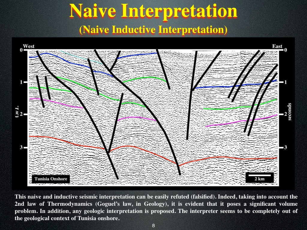
This tentative geological interpretation of a seismic line of Tunisia onshore is a typical naive inductive interpretation proposed by a geoscientist who is not competent to make such a job. He has any idea of what Geology is and any idea about the regional context of the area. In addition, he did try to criticize his tentative interpretation, since for him it is exactly what he see. However, he does not know that you see with your mind and not his eyes (see later). As said previously, a geoscientist sees on a seismic line just what he knows. For a geoscientist knowing the basic principles of Geology, it is quite easy to criticize the above tentative. He recognizes that the sediments lying above a detachment surface (in red in this tentative) were strongly shortened by reverse faults and folds (the only two way of shorten sediments). In addition, knowing that during deformation the volume of the sediments must stay roughly constant, i.e., the Goguel's law, the shortening of the sediments overlying the detachment surface must be more or less the same and the fault planes of the reverse faults must die asymptotically on the detachment surface, what is not the case in this tentative (see next Plate).
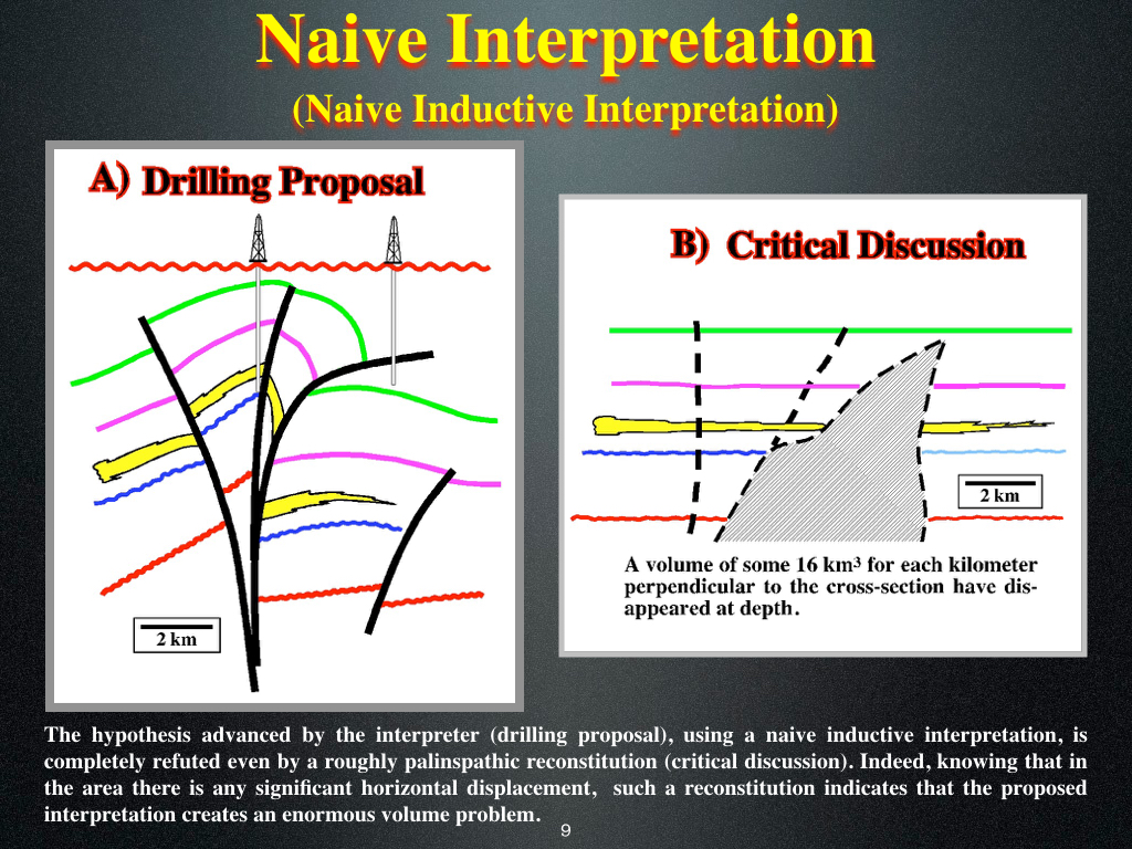
This plate illustrates a true example taken, longtime ago, from a Shell document, in which the chief geologist (a senior geoscientist who knows Geology) explained to a geophysicists (geoscientist who knows Geophysics, but not necessarily Geology) that his interpretation is a non-sense, particularly in an area under a tectonic regime characterized by a sigma 1 horizontal, sigma 2 horizontal and sigma 3 vertical), that is to say, an area where strike slip faults are unlike. In fact, one can easily recognize that the shortening of the seismic markers (green, violet, blue and red) is completely different and. On the other hand, in such interpretation, the geoscientist, as a magician, did disappear more that 16km^3 for each kilometer perpendicular to the cross-section, which in fact, corresponds to a tentative interpretation of a seismic line.
In an hypothetical-deductive interpretation, the geoscientist in charge of the interpretation knows the regional geological context of the area and progress from the general to the particular. When seismic data, from Angola offshore, is given to a geoscientist to interpret, before starting the interpretation, in his brain he makes a review of the Geology of the area : (i) The Angola offshore is associated to the breakup of the Gondwana ; (ii) The Angola offshore corresponds to the stacking of different basins, which are, from the bottom to the top : a) Paleozoic folded belt or Precambrian ; b) Rift-type basins developed during the lengthening of the Gondwana lithosphere, before the breakup, which can be filled by organic-rich lacustrine sediments ; c) A divergent continental margin Atlantic-type, developed above thick post-break subaerial lava flows, which corresponds to the post-Pangea continental encroachment stratigraphic cycle ; (iii) The continental encroachment stratigraphic cycle is composed by a transgressive phase (backstepping geometry), at the bottom, and a regressive phase (forestepping geometry) at the top ; (iv) During the transgressive phase, the geological conditions were, mainly, of highstand, i.e., the margin has often a continental platform ; (v) During the regressive phase, lowstand geological conditions were predominant, what means that, very often, the margin has no platform (the deposition coastal break was, more or less, coincident with the shelf break), what favors the development of turbidite depositional in the deep parts of the margin ; (vi) In the transgressive phase a thick evaporitic interval was deposited, which created an important disharmony tectonic, which is easily recognized on the seismic lines ; (vii) In association with the major downlap surface between the transgressive and regressive phase potential marine source-rocks are deposited. Knowing this geological context the geoscientist knows what he must look for on the seismic lines and what to put in evidence the different petroleum systems.
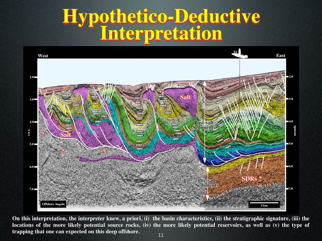
On this tentative geological interpretation, one can recognize the stratigraphy of the area and the main geological events that characterize the Angola offshore, particularly of the deep water. The salt induced tectonic disharmony, that is to say, the limit between deformed (above) and undeformed sediments (below) is easily recognized on the right par of the line. The turbiditic sediments of regressive phase of the continental encroachment are easily recognized, as well as, the shallow water sediments of the transgressive phase. As illustrated on this tentative, the subdivision of the margin sediments in presalt and postsalt sediments do not correspond to any significant geological event, it is just a stratigraphic division.
Very often certain of my colleagues, supporters of naive inductive interpretation, told me that I imposed my ideas and models to the data and that I did not used the data to build a model. I remember very well, that few years ago, when I was interpreting some seismic lines of Cameroon offshore, one of my colleagues told me : "How do you know that this unconformity has an age of 30 My ? My answer was immediate : "Contrariwise to you, I know the stratigraphic signature of the South Atlantic margins, in which such evident unconformity corresponds to the relative sea level fall induced by the formation of the Antarctic ice cap, which took place in Oligocene. In addition, I can, also, tell you that the downlap surface, between the transgressive and regressive phases of the post-Pangea continental encroachment stratigraphic cycle, has an age of 91.5 Ma, i.e., Cenomanian-Turonian and that marine source-rocks are associated with. In other words, if you do not know the theory, you do not know what you must look for". The guy left the room crying to everybody that I was a dangerous man at what I reply sorry, my friend, I'm just a geologist.
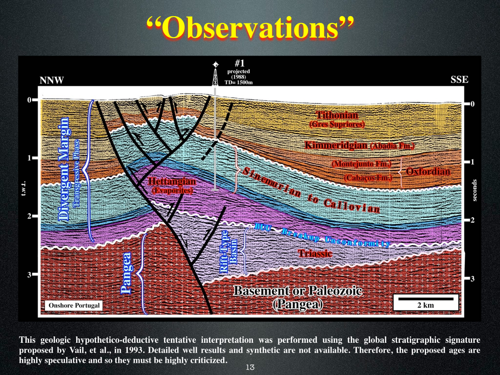
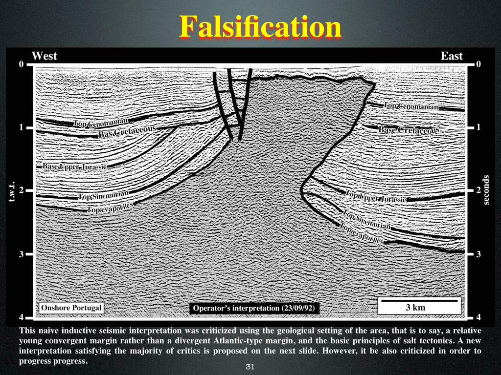
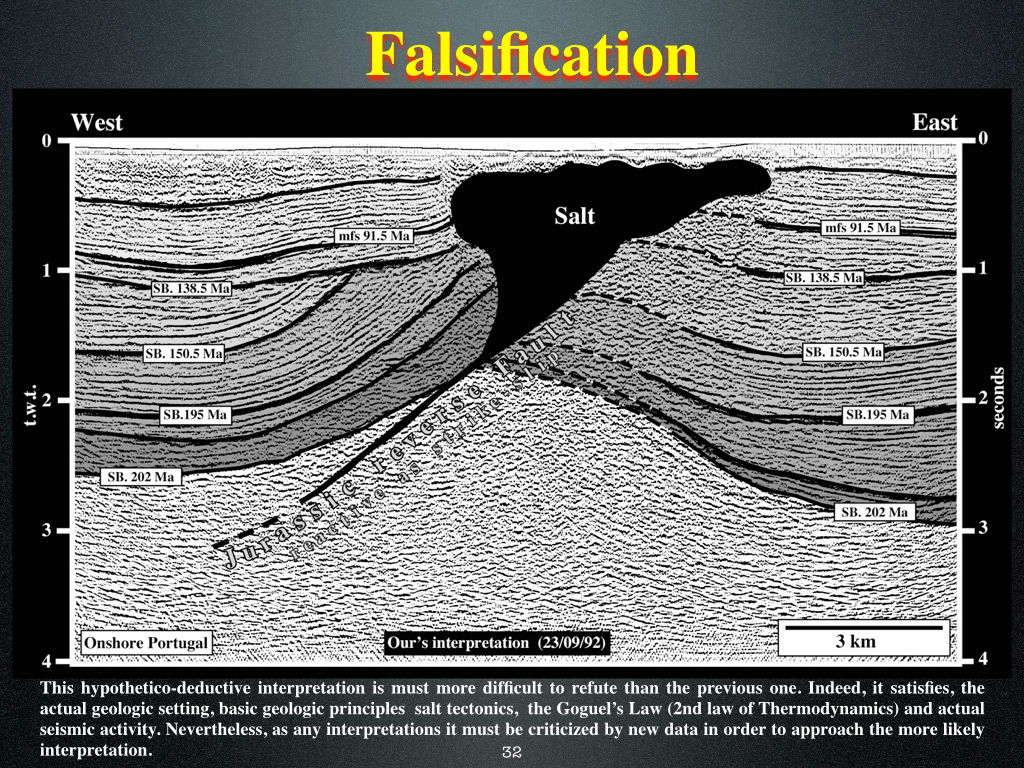
This tentative geological interpretation of a seismic line of Portugal onshore (near Caldas da Rainha) do not refute, i.e., it corroborates the geological context of the area that the geoscientist knew a prior, before starting the interpretation : (i) The Pangea lithosphere (Precambrian or Paleozoic sediments) ; (ii) The pre-rifting unconformity, which is the lower limit of a Triassic rift-type basin developed during the lengthening of the Pangea lithosphere (halfgraben) ; (iii) The breakup unconformity (BUU), which ends the lengthening of the Pangea lithosphere and corresponds to the upper limit of the Triassic rift-type basins ; (iv) the deposition of the margin sediments ; (v) Deposition at the base of the margin of a thick salt layer (Hettangian) ; (vii) Halocinetic movements create a salt diapirs which enhanced, tectonically, the unconformity between the Sinemurian / Callovian and the Oxfordian ; (viii) A post Tithonian compressional tectonic regime shortened the sediments with reactivation of the old normal faults bordering the rift-type basins creating a major tectonic inversion.
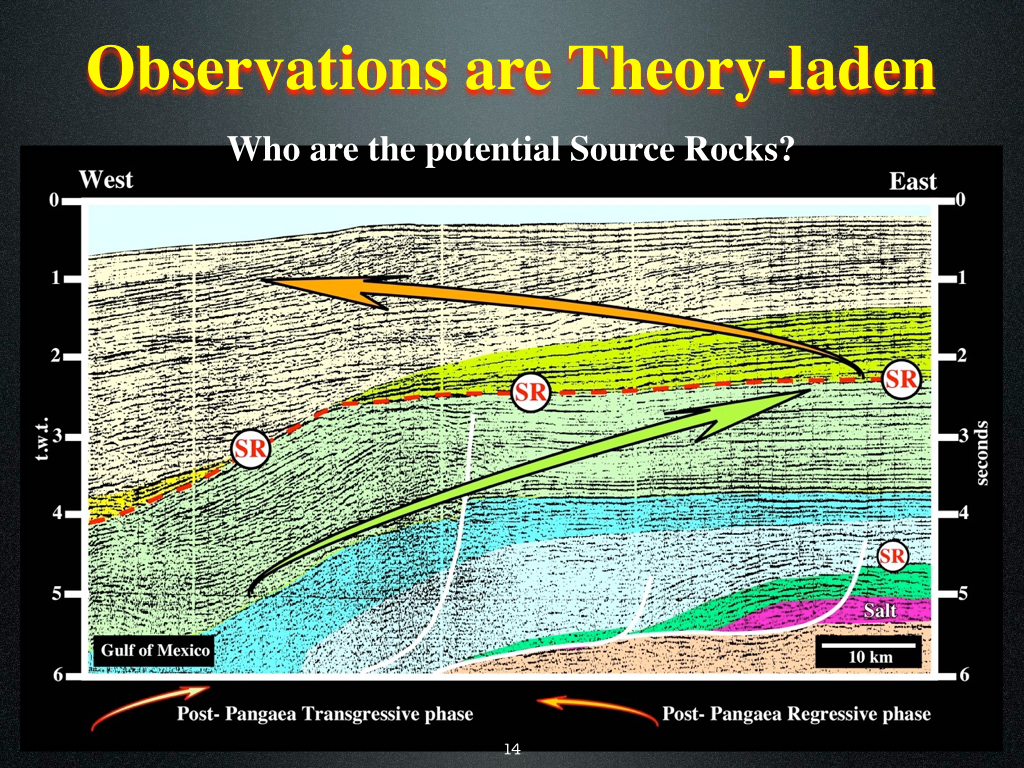
As illustrated on this tentative geological interpretation of a seismic line of the Gulf of Mexico, the more likely location of the marine source-rocks is along the major downlap surface, which separates the transgressive phase of the post-Pangea continental encroachment stratigraphic cycle from the regressive phase. The transgressive phase having a retrogradational geometry and the regressive phase a forestepping geometry, the interface between them is easily identified and picked. This interface corresponds the Cenomanian-Turonian eustatic high, which was induced by the maximum dispersion of the continents individualized by the breakup of the Pangea. In fact, assuming that the volume of water (under all its forms) is constant since the birth of the Earth, when the volume of the oceanic basins is the smallest (maximum development of the oceanic ridges) the sea level is highest.
Do not forget that a geoscientist before starting to perform tentative geological interpretion the seismic lines, he spent several years studying Geology and Geophysics in the High School and University. In other words, when he looks for the first time to a seismic lines is mind is not a white sheet of paper. Contrariwise, he knows already the theoretical knowledge and geological models allowing him to makes observations (Theory precedes Observation). The observations can falsify the model used by the geoscientists and suggest a new model which will guide further interpretations and so on. It is impossible to describe a geological event or an outcrop independently of all theory. In fact, when a geoscientist observes an outcrop and says: "The Cretaceous sandstones outcropping here are rich in autigeneous glacuconite", he is using a lot of theoretical knowledge (Chronostratigraphy, Petrography, Mineralogy, Depositional environments, etc.).
Geological predictions and retrodictions, in terms of lithology, using tentative geological interpretations of the seismic lines, require a sequential interpretation of the data at the hierarchical level of the sequence-cycles. At this hierarchical level, the stratigraphic cycles are deposited during 3th order eustatic cycles (duration ranging between 0.5 and 3.5 million years). On the other hand, as a sequence-cycle is composed by systems tract (synchronous and genetically associated depositional systems) lithological predictions are possible, since a depositional system is a lithology with a typical fauna associated. A delta, for instance, corresponds to a systems tract formed by three depositional systems : prodelta (argile), delta front (sandstone) and alluvial plain (silte).
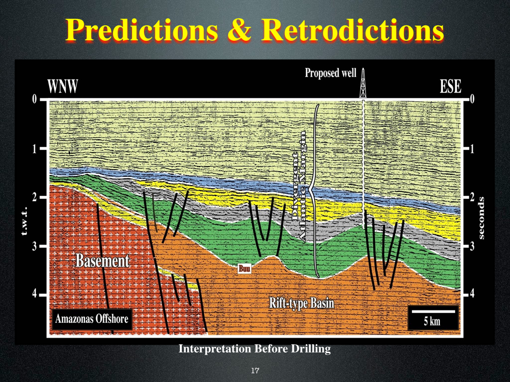
This old tentative geological interpretations of a seismic line of the Amazonas offshore (Brazil) was made using the classic model of non-volcanic divergent continental margin (Atlantic-type). It important to say that, at that time, the majority of the geoscientists working in petroleum exploration assumed that the divergent margins Atlantic-type were non-volcanics, being the Galicia offshore the typical model. Such a tentative interpretation, in which the geoscientists recognize from the bottom to top : (i) Gondawana lithosphere (basement) ; (ii) a large rift-type basin ; (iii) The breakup unconformity (BUU) ; (iv) The divergent continental margin, in which the transgressive and regressive stratigraphic phases seem quite evident, was coherent with the geological model taken as reference. Such a tentative interpretation was later tested by an exploration well, which completely falsify it, as well as, the non-volcanic model of the Atlantic margins (see next plate).
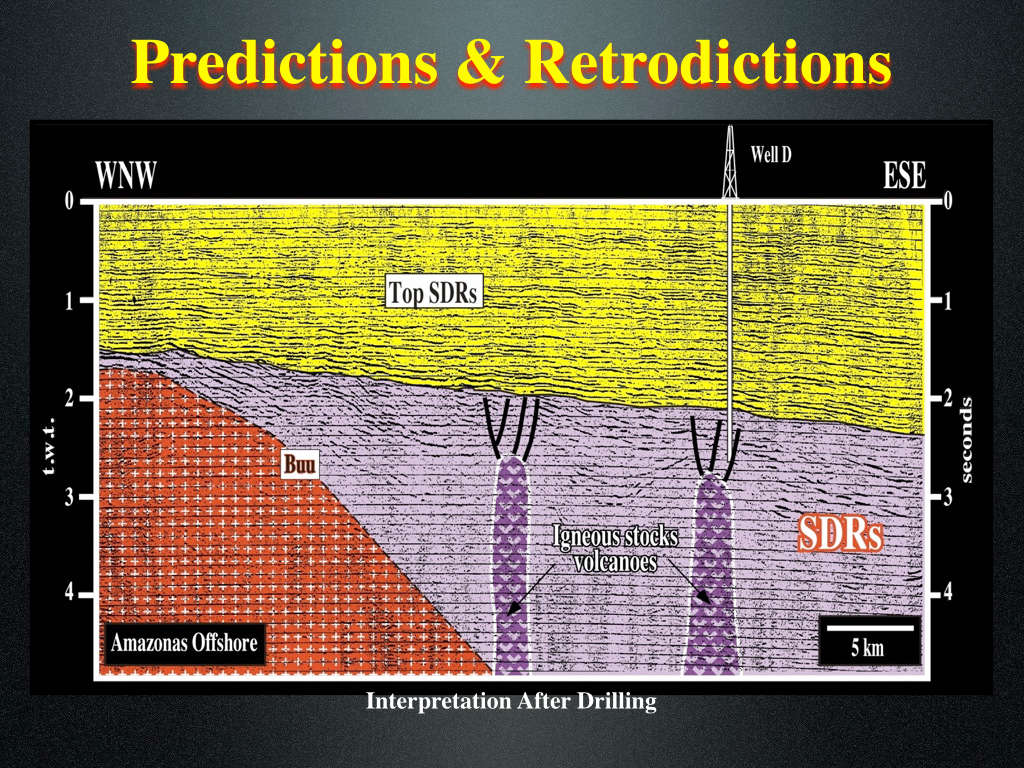
The well results completely falsified the tentative geological interpretation of the seismic line proposed before drilling, which, as said previously, was based in the non-volcanic model for the Atlantic margins as proposed to the Galicia offshore. As illustrated on this tentative geological interpretation, which takes into account the results of the well, the substratum of the margin sediments (interval colored in yellow) is a thick stacking of subaerial lava flows (less than 10% of clastics). The proposed pre-breakup rift-type basin (see previous plate), assumed to be filled by organic rich lacustrine sediments (source-rocks), as in Angola offshore, became a post-breakup volcanic interval without generating potential. After the disappointing results of this exploration well, geoscientists look at all available regional lines of the Atlantic offshore and realized that except Galicia offshore and probably Flemish Cap (Canada offshore), the Atlantic margins are typically volcanic margins. In fact, after the breakup of the lithosphere a subaerial volcanic expansion precedes the oceanization (formation of oceanic crust). Note that in this post drilling tentative interpretation the breakup unconformity is at the bottom of the subaerial volcanic interval.
It is quite important to understand the asymmetry between confirmation and falsification, i.e, between truth and error. If a geoscientist says : "All shales are source-rocks", he can, in fact, observe hundred of examples that corroborate such a conjecture, but he is never completely sure that such a statement is a true. Actually, just one example of a shale that is not a source-rock falsify, completely, the conjecture that all shales are source-rocks. That means that, there is an asymmetry between the truth and error : a geoscientist can never be sure that a conjecture is true (confirmation), but, on contrary, he is absolutely sure of a falsification (an error). Progress in geological knowledge comes from criticism of observations and tentative geological interpretations. All geoscientists working in petroleum exploration know that a dry exploration well gives more knowledge that an oil well. There is nothing worst that find oil with a wrong geological model or with an inaccurate tentative geological interpretation. When a geoscientist try to confirm or verify a tentative interpretation (verificationism according K. Popper), he uses the concept of causality associated to a reasoning by induction. However such a concept is totally illusory since it is based on the idea that science is the search of truth, which it research always by verifications. Actually, a geoscientist can never confirm a tentative interpretation. In science, geoscientists formulate hypotheses (conjectures), invents tests or experiments, not to verify them, but, on the contrary to refute them.
One should not forget that see is not prove. When a geoscientist, and particularly a seismic interpreter see, he is often influenced by his cultural and educational conditioning. In fact, according the large majority of the philosopher of sciences, it is difficult to escape from all of our presuppositions about the world and equally impossible to describe what we see in a language that is objective. In other words, any geologic observation is theory-laden. For instance, when a geoscientist observing a seismic line says: "This unconformity is the upper limit of the rift-type basins", it is obvious that he knows that an unconformity is an erosional surface induced by a relative sea level fall and that the rift-type basins are the basins developed by lengthening of the supercontinents' continental crust (the geoscientist's observation is theory-laden). On the other hand, looking at a seismic line isn't just a process of passively receiving sensory data, but a much more complex process of receiving, selecting and categorizing information. Even seeing that "the seismic amplitude is red" turns out to be an extremely complex process. When a geoscientist looks at one tentative interpretation, electromagnetic waves in the form of white light illuminates the tentative. Part of the white light is absorbed and part reflected. Specific wavelengths enter the eye, stimulated retinal cells, cause complex chemical and electrical changes in the geoscientist's brain and end up at the visual center at rear of his brain. So he sees with his brain an internal representation of the tentative interpretation and not the reality. In addition, the clean seismic line itself represents, in time, a copy of the reality. On the other hand, not everybody sees the same colors in the tentative interpretation. (Robinson, D. 2005).
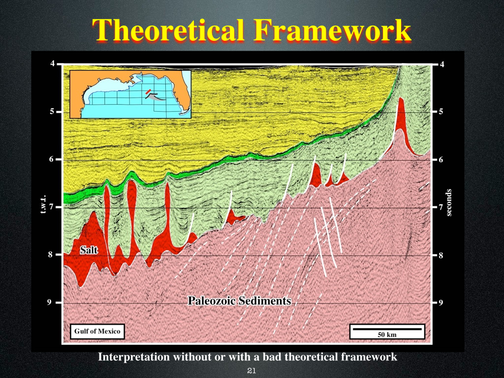
Obviously, this tentative geological interpretation of a regional seismic line of the Gulf of Mexico was made with a wrong theoretical framework (Atlantic margins are non-volcanic). The interval considered in this interpretation as Paleozoic sediments corresponds, in fact, to a staking of post breakup subaerial lava flows (SDRs), on top of which lava deltas are evident. If the geoscientist knew the more likely geological setting of this area, illustrated on the next plate, he will proposed another tentative interpretation.
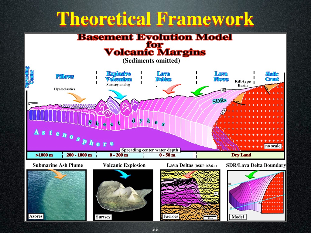
This sketch illustrates the geological setting of the Gulf of Mexico at the time of the breakup of the Pangea. The lengthening of the lithosphere is corroborated by the formation and filling of rift-type basins. The breakup of the lithosphere and the zone of breakup are corroborated by the thinning and highly volcanic intruded zone of the lithosphere. The subaerial accretion of the margin is corroborated by the deposition of lavas flows (subaerial volcanic crust) and the oceanic accretion by the formation of oceanic crust. It is interesting to notice that function of the water depth of the spreading centers different volcanic structures can be recognize : (i) Lava flows (SDRs) ; (ii) Lava deltas ; (iii) Explosive volcanism ; (iv) and pillow lavas (oceanic crust) over which hyaloclastics can be deposited.
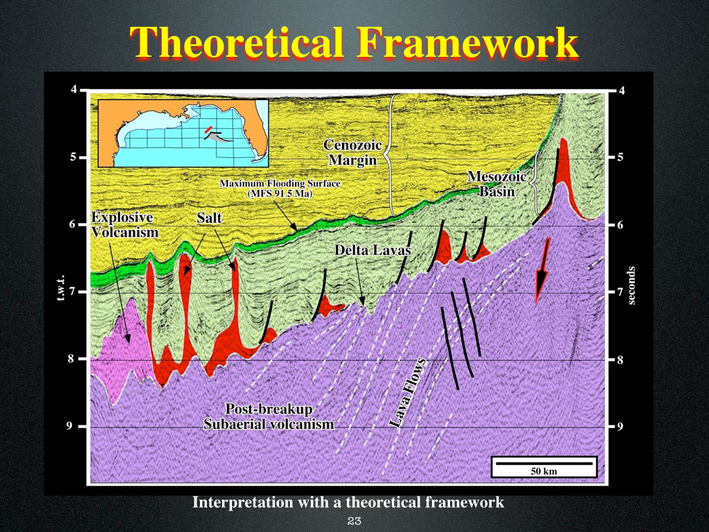
In this tentative geological interpretation of the previous seismic line of the Gulf of Mexico, the geoscientist in charge of the interpretation took into account the geological context of the area (The Atlantic margins are volcanic margins with subaerial lava flows at the bottom of the margin). He easily recognized the post breakup subaerial volcanic crust, i.e., the seaward dipping reflectors, as well as, the lava deltas and the explosive volcanism.
A geological conjecture is an hypothesis advanced to explain a certain geological feature, that must be always tested. If the test is negative, i.e, if the test does not refute the conjecture, there is no progress. On the contrary, if the test refutes the conjecture, there is a significant progress, since the geoscientist in charge of the interpretation must advance another conjecture taking into account the results of the previous test and so on. In Science and particularly in seismic interpretation, we progress by trial an errors.
According to K. Popper the demarcation line between science and pseudoscience is the falsification. All scientific geological statements must be falsifiable, as for instance "This antiform is a compressional (shortened) structure". All statements than cannot be falsifiable is not scientific, as for instance, "the presence of source rocks is function of the geologic evolution of basin". Conjecture or hypothesis that resist to falsification tests are often called sanctioned truths. The statement "This antiform is a compressional (shortened) structure" can be tested by a perpendicular line to the axis of an structure. If we find normal faults synchronous of the deformation at the apex of structure, it cannot be a compressional structure, since one cannot shortened and lengthened the sediments at same time in same place. The difference between a naive inductive geoscientist and a scientific one can be seen as follows : Instead of saying "I'm going to accumulate observations or experiments to verify them my hypothesis (naive inductive), the real geoscientists imagine observations or experiments, that is to say, falsification tests (refutation tests) of the hypothesis that himself advanced previously.
Naive inductive geoscientists never test their tentative geological interpretations of seismic data. They used to say, it my own interpretation and it is not influenced by my cultural or educational conditioning. Geoscientists performing a scientific tentative interpretation, pick several times the same data (what a inductivist consider a lost of time) always test their tentatives, since they know that there is not bad or good tentative interpretations, but just refutable tentative. A tentative which resist better to falsifiable test is probably the more coherent in relation to the available data. However, with new data it can be easily refuted.

Send E-mail to carloscramez@gmail.com with questions or comments about these notes .
Copyright © 2012 CCramez
Last modification:July, 2014