In spite of the fact that there are significant dissimilarities between the hypothesis advanced (before 2000) to explain the Atlantic-type divergent margins and particularly those associated with the opening of the South Atlantic, they can be group in a "conventional model" and depicted as follows:
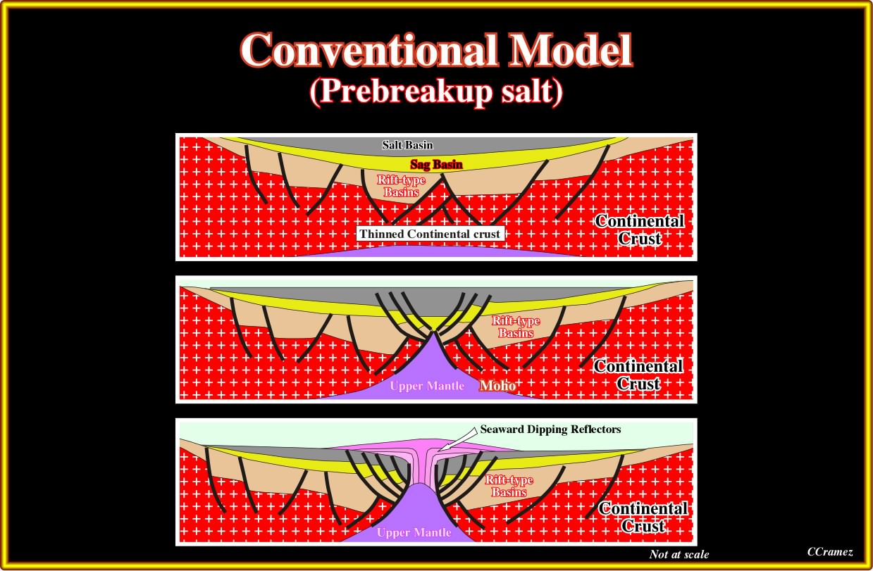
Plate 011- In a conventional model, there is just a single proto-oceanic basin (sag basin for certain geoscientists) and a single salt basin above complex rift-type basins. The rift-type basins, associated to a first lengthening phase of the lithosphere, have a strange geometry and thickening (easily refuted by seismic data). After the deposition of the sag and salt basins, a new lengthening phase breaks the lithosphere, individualizing two tectonic plate, allowing the deposition and development of the subaerial lava flows, and later the formation of the oceanic crust (pillow lava). In other words, the subaerial lava flows postdate the breakup unconformity, but the breakup is posterior to deposition of the salt. In this model there is an unique salt basin, which, later, is subdivided in two - the Congo-Angola and the Brazilian salt basins.
In the model proposed by Burchfield, as illustrated below, the major tectonic event, i.e., the breakup of the lithosphere is completely masked. It seems to occurs between the lower (Rift-type Basins) and the upper (Mature Divergent Margin) block diagrams, probably after the deposition of the sag basin. Nevertheless, as the model is depicted, one can always said the opposite (no falsifiable model in the sense of K. Popper).
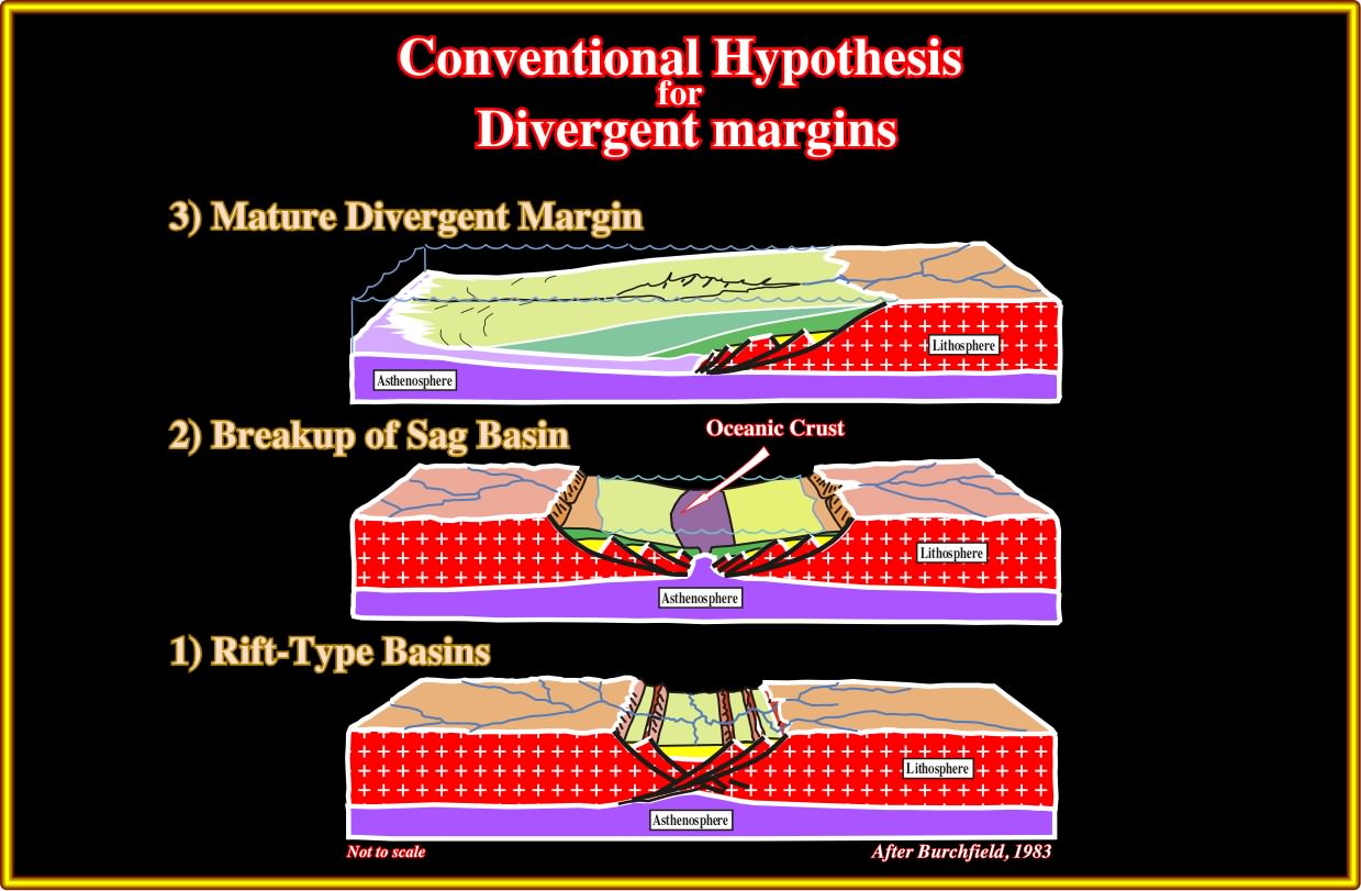
Plate 012- The Burchfield’s hypothesis, which still is followed by a lot of geologists, have been, even before 1983, refuted by long regional marine seismic lines. In this hypothesis, three major stages a considered : (i) Rift-type basin formation ; (ii) Breakup of a sag basin and (iii) Mature divergent margin. The geological implications of such a hypothesis can be summarized as follows : (i) Normal faulting, in which normal faults (opposite vergence) length the lithosphere, what creates, by differential subsidence, a lot of rift-type basins, which were filled mainly by non-marine sediments, eventually with potential source-rocks ; (ii) After rifting, a sag phase (thermal subsidence) allows the deposition of a cratonic basin (sag phase), in which sediments such as evaporites encroach the basement by onlapping fossilizing the rifting sediments ; (iii) The breakup of the lithosphere takes place during or after the sag basin with the onset of seafloor spreading and development of a margin with a progradational geometry. Summing up : This model implies : (a) No subaerial volcanism ; (b) Breakup by thinning of the lithosphere ; (c) A single salt basins predating seafloor spreading ; (d) Salt brines not enriched hydrothermally. All these features have been falsified since long time.
The majority of the geoscientists working in oil company just became aware of the existence subaerial lava flows (seaward dipping reflectors) when hydrocarbon exploration shift to deep water offshore. However, academic geoscientists knew their existence since longtime (seismic interpretation, coring, field working), as illustrated below.
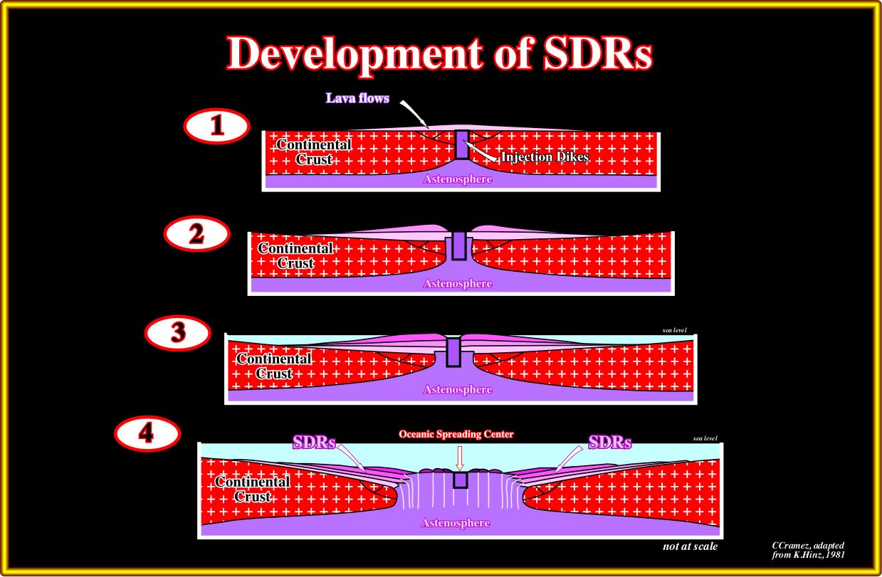
Plate 012- In the 80’s, several geologists explained the SDRs considering that crustal extension and thinning occurred during the processes of crustal rupture and it was followed by injection of dikes and basaltic flows developed in subaerial environments either creating structurally raised areas or filling local lows forming thick deposits of volcanic rocks, volcano clastics and siliclastic sediments. The model illustrated in this plate, was proposed by K. Hinz to explains the origin, age and evolution of the SDRs. It suggests a breakup induced by intense injection of mantle dikes rather than a thinning of the lithosphere. However, it does say anything about the evolution of the margins, particularly how salt basins were developed and why the evaporite deposits of Atlantic margins are so rich in potash and so poor in MgS0_4.
It is interesting to notice that this model (intense injection of mantle dikes) is older than the model proposed, mainly by french academic geoscientists, by thinning and lengthening of the lithosphere to explain what they observed on the seismic lines shot on the Galicia offshore (see later).
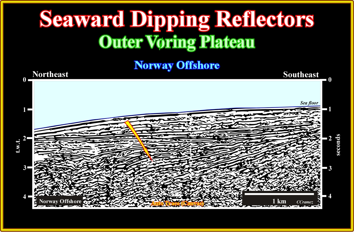
Pl013- On this line of the Norway offshore (notice that what is depicted is an auto trace of the original seismic line using Canvas drawing program), below the two uppermost seismic intervals, characterized by a parallel internal configuration, seaward dipping reflectors are obvious. On the other hand, it is easy to recognize that such a seismic reflectors are convergent landward, that is to say, the interval between to consecutive reflectors thins continentward.
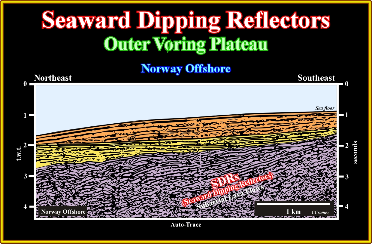
Pl014- When long regional marine seismic lines were shot on offshore Norway and South Atlantic, geoscientists recognized a consistent thick seismic interval composed by divergent dipping reflectors seaward. As the lithology of such a typical deep-water reflectors was unknown, they labelled them SDRs, i.e., seaward dipping reflectors, suggesting than a DSDP well should recognise their facies, since a lot of geoscientists, particularly those working in oil companies interpret them as sediments deposited in rift-type basins with generating petroleum potential.
In South Atlantic, after the oil discoveries in Angola and Brazil (onshore and offshore), geoscientists realize that the more likely source-rocks, responsible for the oil generation, were the lacustrine shales deposited in the rift-type basins developed, below the evaporitic interval (the basal margin sandstones are often under seismic resolution), during the lengthening of the Gondwana lithosphere. However, on the first seismic lines shot in the southwestern Africa provided evidence, mainly seaward of the basement, of huge reflectors dipping seaward. Geoscientists associated such a reflectors to organic-rich rift-type basin sediments (equivalent to the Cabinda's Bucomazi formation) and SWAPO (South-West African People's Organization) started to speak in a coming Namibia offshore Eldorado, which strongly reinforced the Namibia independence desire (21 March 1990).
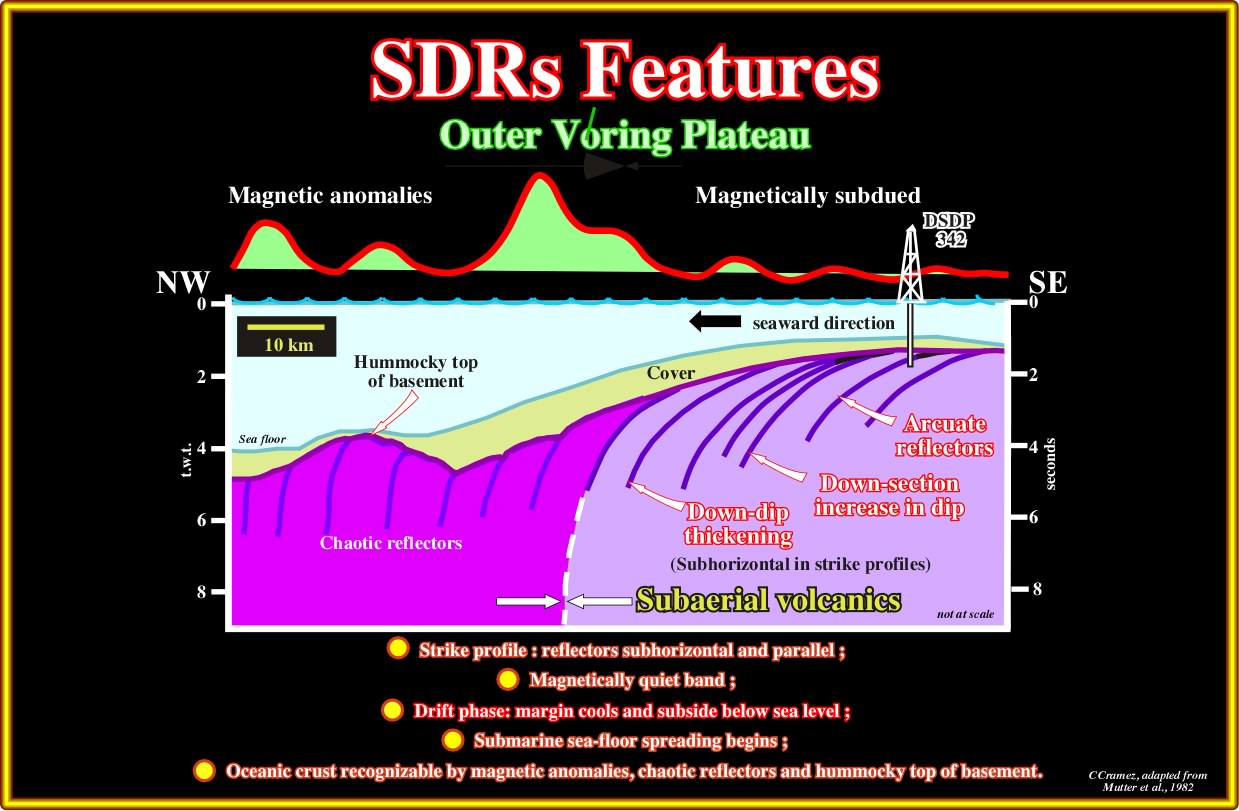
Pl015- The DSDP 342 recognized a subaerial volcanic facies for SDRs, i.e., lava flows spreading and thinning toward the continent). As suggested on this tentative geological interpretation, it is easy to hypothesize that since the spreading centres become immerse the extruded volcanic material froze (volcanics cannot flow under water) forming pillow-lava which form the normal oceanic crust. Subsequently, above the SDRs (horizontal geometry), magnetic anomalies are subdued, while above oceanic crust (vertical geometry)they are well visible. On the seismic lines, oceanic crusts creates chaotic reflectors, while subaerial lava flows give arcuate continuous reflectors.
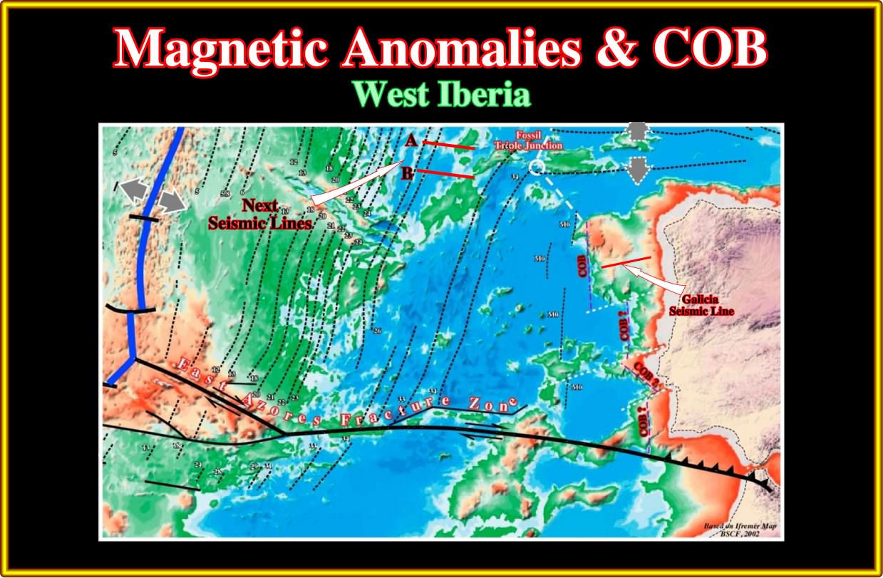
Very likely the first deep water offshore seismic lines published in academic literature were the seismic line of Iberia margin (Galicia offshore), one of which is illustrated in the next plate. Immediately, such lines were used by all naive geoscientists (inductive sense) as the representation or the model for Atlantic-type divergent margin, which they, subsequently, considered as non-volcanic margins. Unfortunately, as shown next and all along these notes, not only, the Galicia offshore does not correspond to a conventional Altlantic-type divergent continental, but the large majority of the Atlantic-type divergent margins (associated to the breakup of the Pangea) are mainly volcanic margins.
Actually, several geoscientists consider the West Iberia offshore not as a divergent margin but as an early convergent margin (do not forget the Wilson cycle). They recognize, in this offshore, a North-South incipient type B subduction zone, which is the responsible for all compressional earthquakes reported, in the area (Portugal and Spain), since XII century.
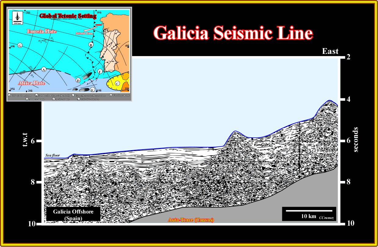
Plate 016 - This seismic line, initially interpreted by Reston & Turner, clearly suggests that a lengthened continental crust lies over the upper mantle, which outcrops in the western end. The limit between the continental crust and the upper mantle, that is to say, the Moho discontinuity is here underlined by a detachment or décollement surface. Four major interval must be differentiated in the continental crust : (i) Substratum, probably granite-gneiss ; (ii) Paleozoic pre-rifting sediments ; (iii) Mesozoic rift-type sediments and (iv) Ceno-Mesozoic post rifting sediments. The fault geometry, the morphology of the pre-rifting and the breakup unconformity, as well as, the particular filling of the rift-type basins are key elements to understand the COB (Continental Oceanic Boundary), and may be why SDRs are not evident or absent in this offshore, which naive inductive geoscientists have considered as a typical no volcanic margin.
The topographic map of onshore Iberia underlines the probable presence of old fracture zones striking NE-SW, and N-S, which likely controlled the breakup of the Pangea lithosphere and the subsequent seafloor spreading. The bathymetry corroborates the hypotheses that N-S lineations could be the surface expression of rifting faults and that NE-SW lineations could or the old transform faults, which seem to pursue the Pangea fracture zones.
An interval velocity cross-section based on a regional seismic line and a close-up of this one corroborates (but not validate) the proposed hypotheses. The velocity interval profile in north offshore of Iberia (Galicia Interior Basin, Galicia bank, Deep Galicia Margin) suggest that the Moho discontinuity surface is relatively shallow, i.e., ± 5 km below sea floor in Deep Galicia Margin and at around 10-15 km in Galicia Basin. In other hand, pre-rifting sediments and rift-type basin, with velocity interval lower than 5 km/s are well predicted all along of the profile. On the western end, a peridotite ridge marks the onset of the oceanic crust.
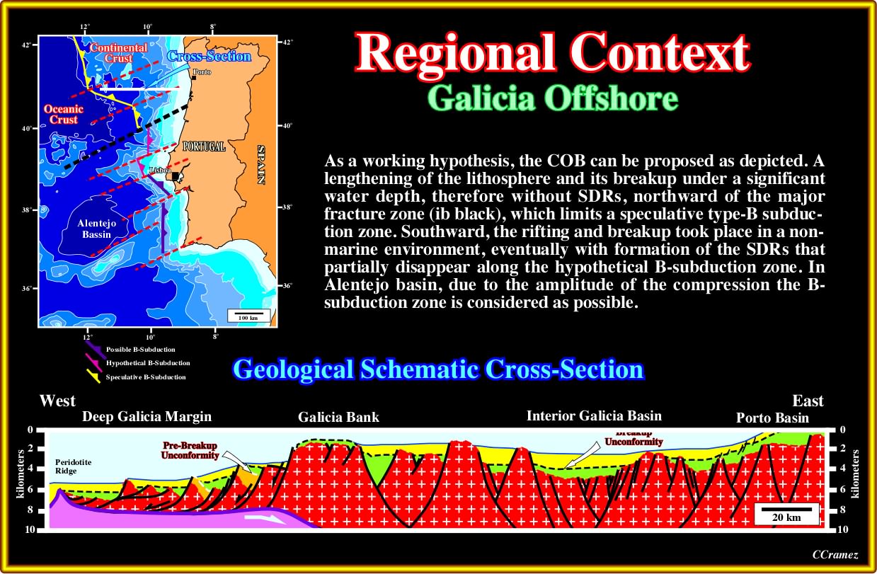
Plate 017- A regional schematic cross-section between Deep Galicia Margin and Porto Basin can be depicted as illustrated. In this interpretation, it is hypothesized the onset of a subduction of the oceanic crust under the continental crust (Galicia Bank - Porto Basin). The downward flexure of the lithosphere throwing the upper surface of the plate (continental crust between Galicia Bank and Deep Galicia margin) into tension creating a local extensional tectonic regime, which can be the responsible of the detachment and reactivation and deformation of preexisting normal rifting faults. The southern limit of such a conjecture is a major fracture zone suggested by the bathymetry and corroborated by geologic and seismic data. Indeed, southward of this fracture zone, the rift-type basins were filled by non-marine sediments and evaporites, probably potash evaporites, were deposited at the base of the margin.
Southward of the fracture zone illustrated above (black dotted line), a regional compressional tectonic regime, probably associated with a developed type B subduction zone, is quite evident, in the onshore basin (Lusitanian basin), where tectonic inversions are paramount, as we will see later.
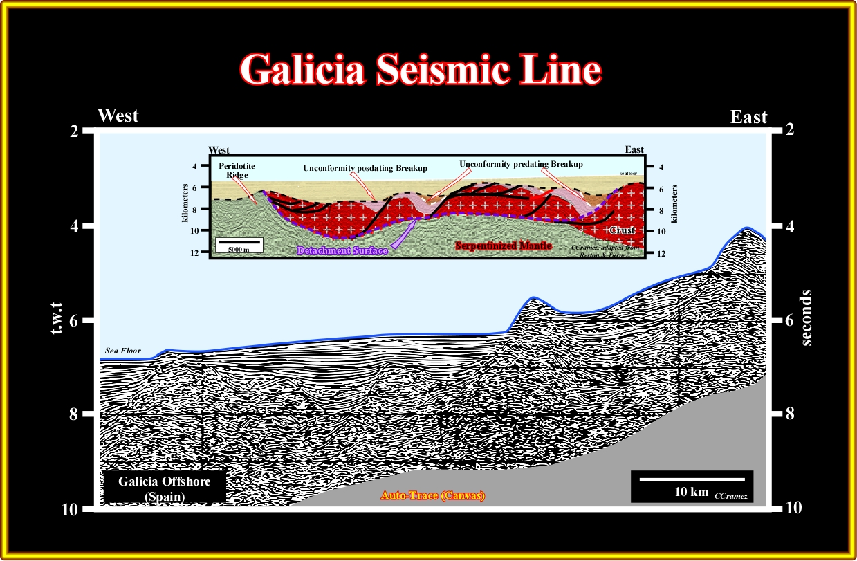
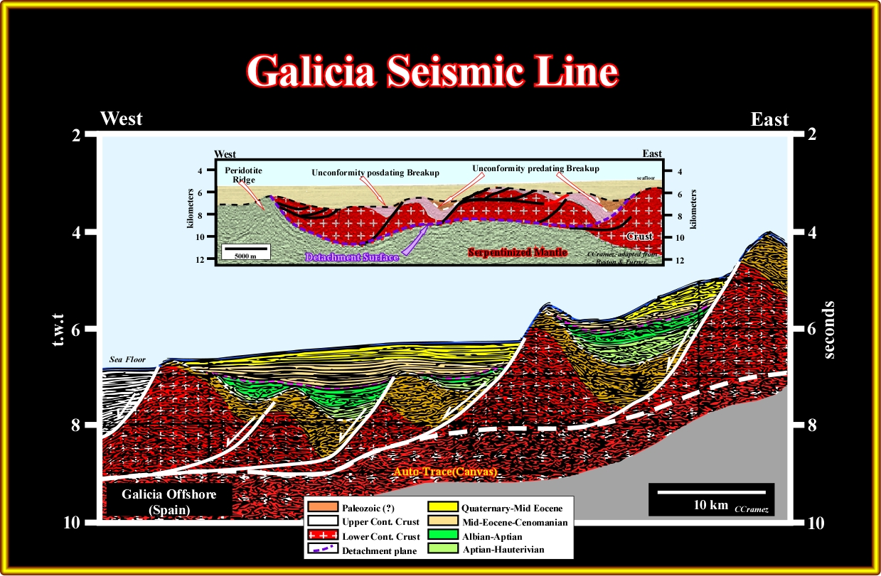
Pl018- The detachment surface, the pre-rift (bottom of green seismic interval) and breakup unconformity (in black) are evident. The rift-type basins are starved. They are partially filled and the associated sediments are deep-water, which is not the case in the majority of the margins. As suggested by the rifting escarpments, facies and environment of the rift-type sediments, it is plausible that during the rifting all or part of what became the atypically West Iberia, was under high water depth. When to breakup took place, the basaltic material could not flow toward the continent creating SDRs, since under water it is frozen creating pillow-lava what we normally dub oceanic crust. Let’s now see what is going on eastward of this line, that is to say, between the deep Galicia margin and the Galicia Bank.
The prevailing question is : Are there SDRs in Iberian Peninsula offshore? The answer is no and yes. Two particular reasons can be advanced, which we will review next. The COB (continental oceanic boundary) in deep offshore Newfoundland and Iberia are quite anomalous in relation to the COB in North Africa and offshore USA, where SDRs are well known. On the other hand, the morphology of the sea floor is also quite particular, as shown next.
Pl019 – From North to South, it is easy to recognise : Galicia Bank, Vasco da Gama - Vigo - Porto seamount of the Iberia abyssal plain, Estremadura Spur, Tore seamount, Tagus abyssal plain, Gorringe Bank, Horseshoe abyssal plain and Madeira Tore Rise. The mid-oceanic ridge, Azores islands, Azores Biscaia rise and Kings through are also easily recognized. As illustrated next, this bathymetry fits with the bathymetry of offshore Newfoundland. In the other hand, in West offshore Iberia, one can recognise the fossil triple junction, Mid-oceanic ridge, East Azores fracture zone, magnetic anomalies and the hypothetical continental oceanic boundary (COB). The apparent displacement of the limit between continental and volcanic (subaerial or oceanic) crust seems to be controlled by old fracture zones (see next), which seem to be more or less reactivated during sea-floor spreading.
A reconstruction at the magnetic anomaly M0, around 118 Ma, strongly suggest, at the onset of the seafloor spreading, that the Galicia Bank was adjacent to Flemish Cap. The Iberia and Tagus Abyssal Plains seems also to match with the North and South Terra Nova basins. A major fracture zone existed already between south Newfoundland and south Iberia. A triple point, northward of Flemish Cap and Galicia bank could be predicted. The extension between M0 and M25 (see later) shows the lithospheric plate movements and strongly emphasized the geological particularities of Newfoundland and West Iberia offshore when compared with the conventional Atlantic offshores. Notice in north Iberia, the Neo-Tethys Sea and a triple point between Galicia Bank and Flemish Cap in which SDRs are likely as illustrated next.
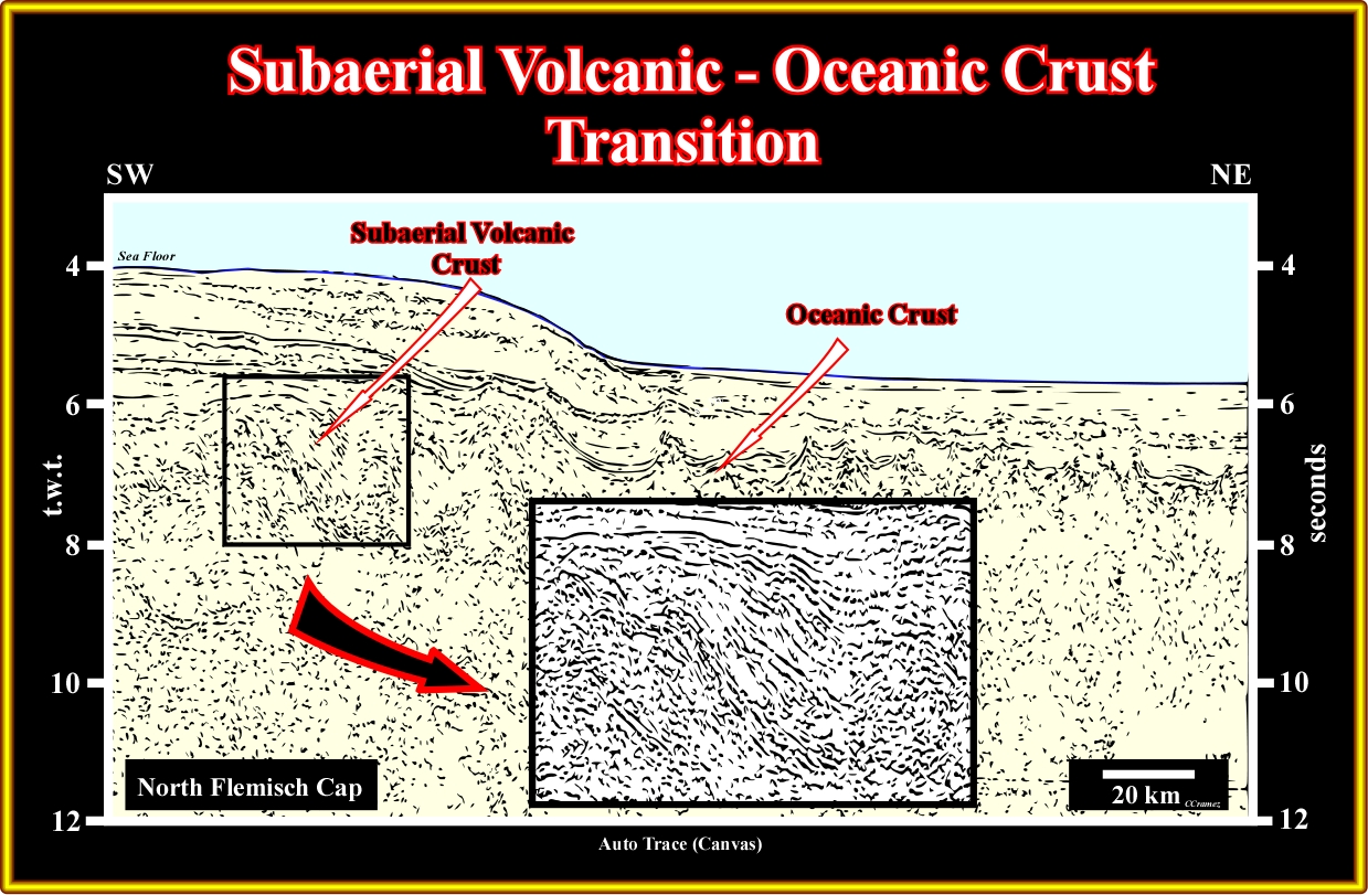
Plate 020- On this regional seismic line, located slightly northward of Flemish Cap, the transition between the subaerial and the oceanic crust can be recognized on the left part of the line. In fact, seaward, the oceanic crust is easily recognized by its mounded or hummocky morphology (take into account the scale) with small volcanic basins between volcanic ridges. Potential SDRs can be recognized in western part. Their morphology can be better recognized in the close-up shown in central part of this plate.
The close-up can be interpreted as a stacking of successive lava flows. In fact, the interval between successive reflectors thins westward, in direction of the craton, and several disconformities can be individualized. In addition, certain structures look like lava-deltas with a SW vergence. If these reflectors correspond to subaerial lava flows, one can say that the rifting took place in a continental environment and that the associated rift-type basins must be filled mainly by non-marine sediments.
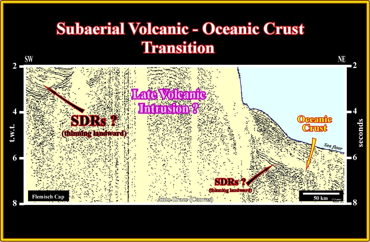
Plate 021- The seismic lines through Flemish Cap are not too significant as illustrated by this seismic line (Lithoprobe). Nevertheless, taking into account the areas underlined by the red arrow), it is possible to hypothesize a limit between the oceanic and subaerial crust eastward of the Flemish Cap. In such highly falsifiable hypothesis, the facies of the Flemish Cap must be subaerial volcanics. On the right, the oceanic crust is easily recognized by its hummocky morphology. Above, the thinning landward interval (arrow) can be interpreted as lava-flow connected seaward with sheeted dyke,, i.e., a spreading centres. Westward of Flemish Cap, besides the volcanic intrusion and associated lava-flows visible on the eastern side of the line, some reflectors can be interpreted as seaward dipping reflectors. If such interpretation is right, one can hypothesise that the breakup of the lithosphere took place in an subaerial continental environment as in conventional Atlantic-type margins (Galicia offshore excluded).
The association between the subaerial lava flows (seaward dipping reflectors on seismic lines) and salt derived from hydrothermal enriched brines is well know since longtime. The lake Assal (Bahr al Assal), in Djibouti, is the Africa's lowest geographic point. It lies 155 meters below sea level. It's a fascinating salt water lake, with beaches literally made of pure salt. Some of the salt banks are over 65 m deep. Lake Assal is saltier than Dead Sea and you don't have to swim a single stroke - you can just float. I guess, you may have heard of the salt caravans that travel from Lake Assal into the Ethiopian Highland, but you probably never thought that such salt is strongly associated with the subaerial lava flows, i.e., the SDRs that geoscientists consider as a characteristic of the majority Atlantic-type divergent margins.
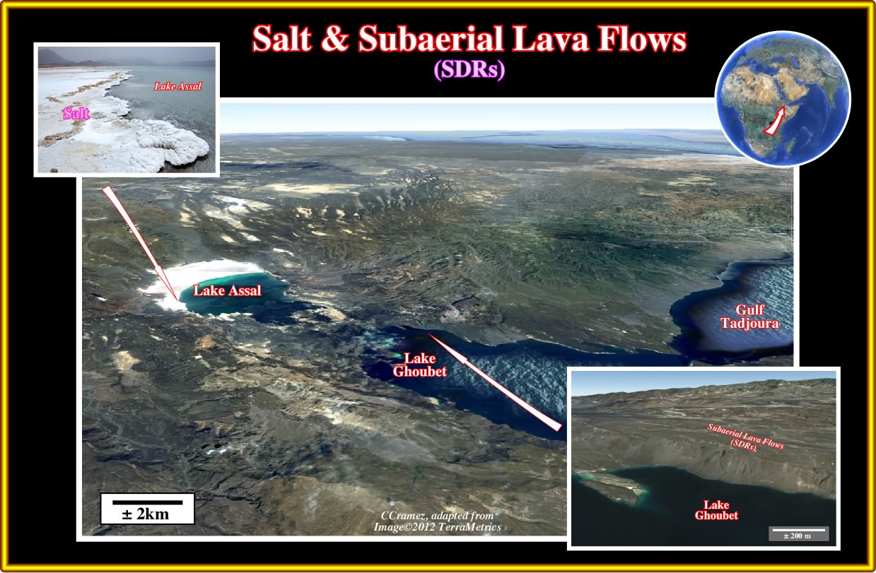
Plate 022- One of the best recent examples, where MgSO_4 poor potash evaporites is formed by spilitisation of the basalt of the lava flows, is the Lake Assal, which is located at the junction of Aden Ridge, Ertaiale Red Sea rift axis and the East African rift axis.
As it is well known the Afar (a nomadic tribe) have been cutting slabs of salt from the lake Assal and other small hydrothermal enriched salt accumulations for centuries and continue to do so today. The subaerial lava flows, which enrich hydrothermally the brines can be easily studied on the northeastern bank of the lake Goubet as illustrated above.
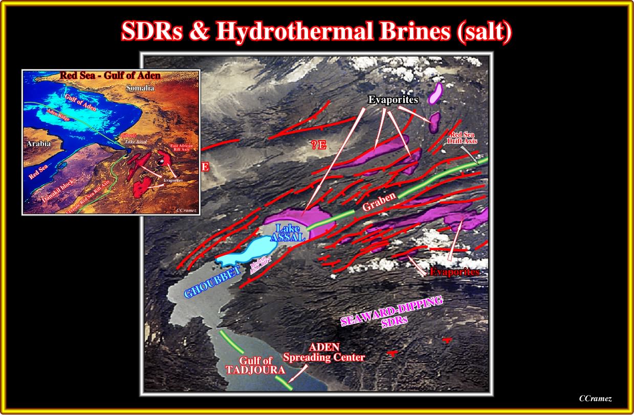
Plate 023- The evaporites deposited in Lake Assal and associated grabens have the same composition of the South and North Atlantic margins, as well as the Lohan salt of Gulf of Mexico. Admittedly, their brines are hydrothermally enriched by the rocks composing the SDRs, which are easily recognized on the field. The water level of the Lake Assal is around 250 meters below present sea level.
The basalts of lava flows are the most suitable host to explain potash evaporites poor in MgSO_4 that we found in the evaporitic Atlantic-type divergent margin, such Angola offshore, Brazil offshore, Gulf of Mexico, Baltimore Canyon, etc.
to continue press
next

Send E-mail to carloscramez@gmail.com with questions or comments about these notes (Altlantic-type Divergent Continental Margins).
Copyright © 2012 CCramez
Last modification:July, 2014