
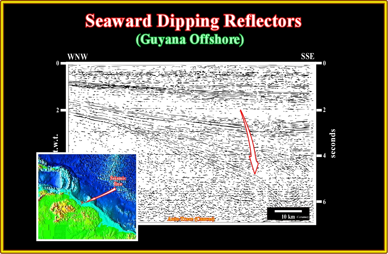
Plate A17.01- The presence of the seaward dipping reflectors in Guyana offshore is obvious as suggested by this seismic line, which tentative interpretation is illustrated in next plate.
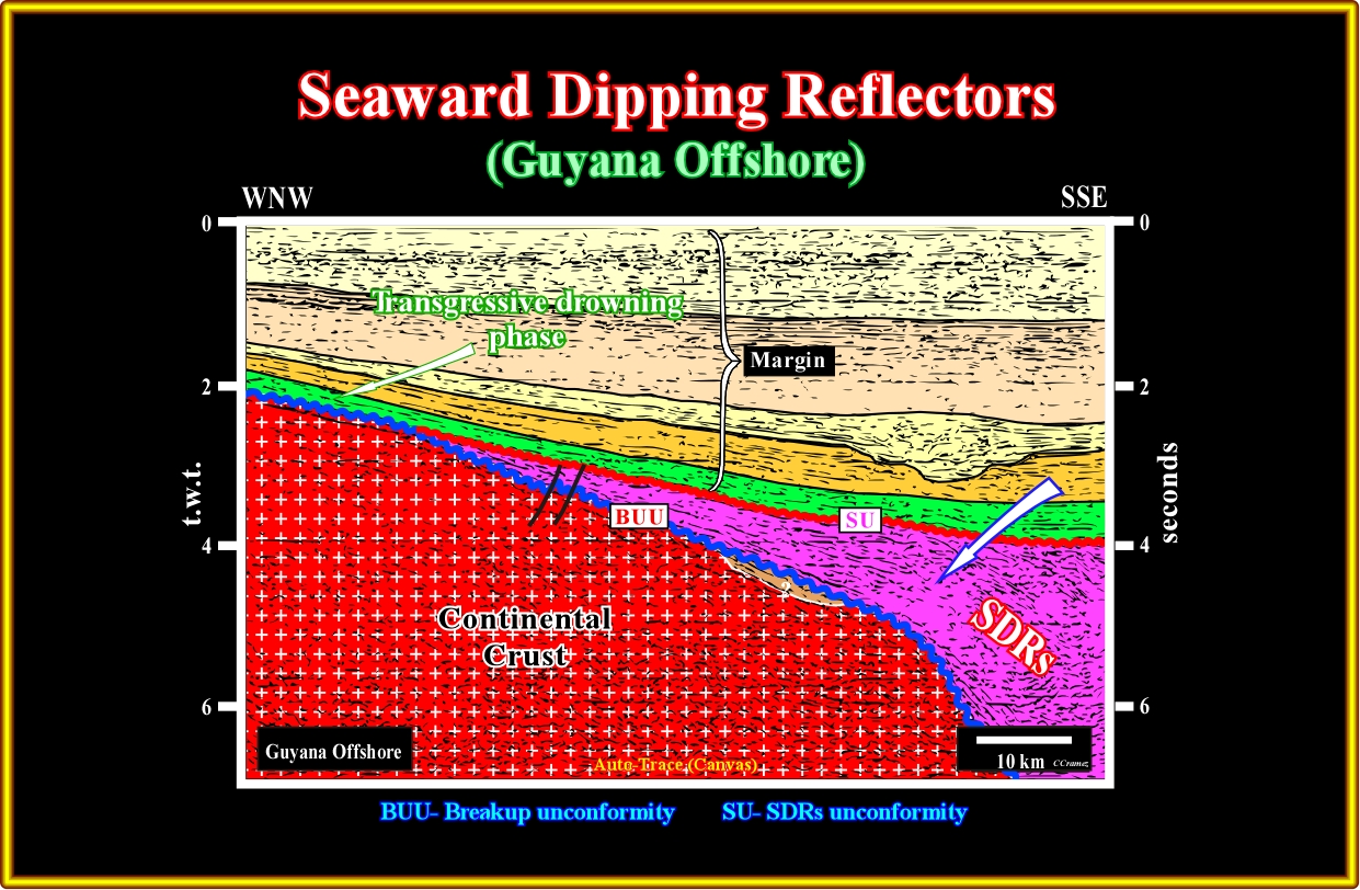
Plate A17.02- As depicted, the differentiation between the SU unconformity (top of the SDRs) and the BUU unconformity (breakup unconformity, at the bottom of the SDRs) is here quite obvious. The SDRs, probably eroded a little bit, were fossilized by the deposition of the transgressive phase of the post-Pangea continental encroachment stratigraphic cycle. The volcanic facies (lithology) of the SDRs was corroborate by several exploratory well's results. Notice, in middle eastern part of the seismic line, the sandprone infilling of a large submarine canyon.
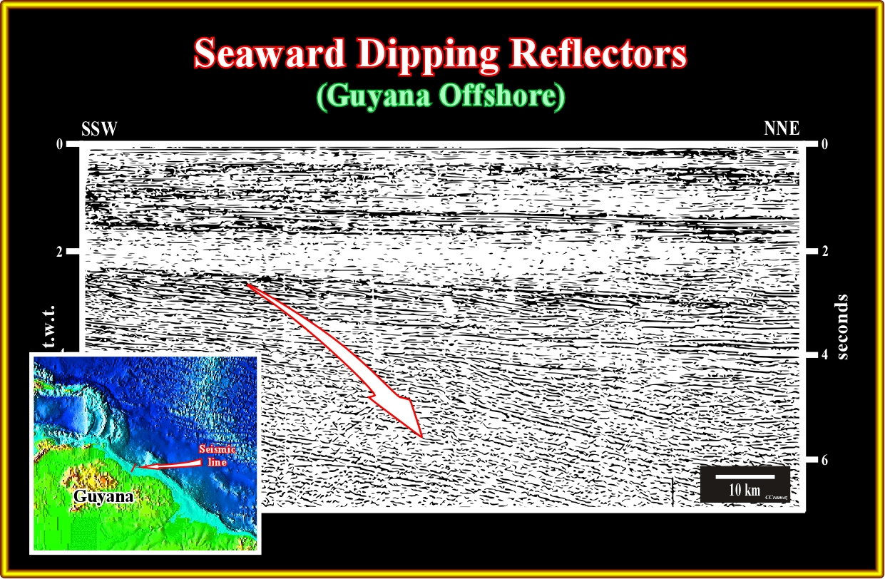
Plate A17.03- The volcanic facies of the SDRs recognized on this seismic line (see tentative interpretation on the next line), was corroborated by the exploratory wells drilled landwards. Don't forget that the unconformity at the top of the SDRs is not the breakup unconformity, but the SU. The difference in age between this two unconformities can reach 10 My.
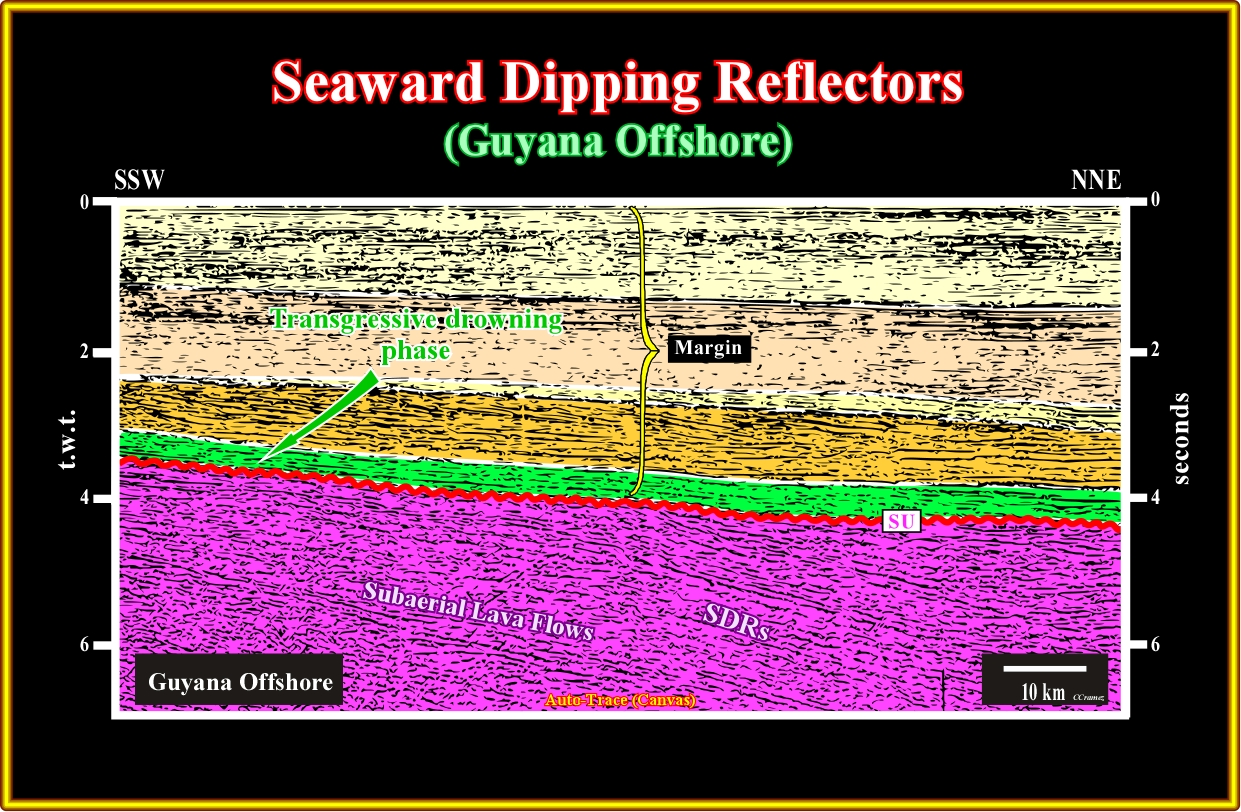
Plate A17.04- As illustrated in this tentative interpretation, the SDRs,, partially eroded at the top, were fossilized by the transgressive sediments (in green) of the transgressive phase of the post-Pangea continental encroachment cycle. The limit between the transgressive and regressive phase of such a cycle is well recognized by the major downlap surface at the bottom of the yellow interval.
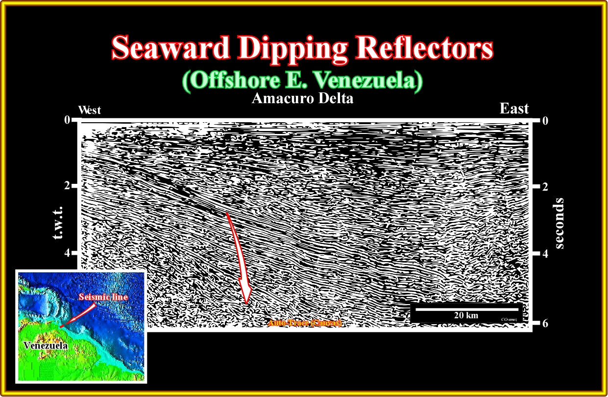
Plate A18.01- I guess than any geoscientists knowing the a priori existence of the SDRs, that is to say, that subaerial lava flows are emplaced since the breakup of the Pangea lithosphere recognize them on this regional seismic line of the Amacuro delta in Venezuela offshore).
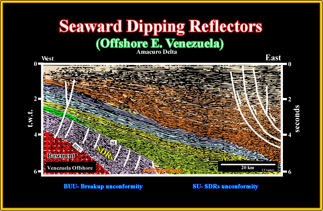
Plate A18.02- On this tentative geological interpretation of the previous seismic line, the SDRs are obvious. Due to their seaward tilting, in response to the loading of the younger lava flows, they were affected by normal faults, mainly looking landward, in order to respect volume problems (Goguel's law). It is interesting to recognize a turbiditic fan along the major downlap surface, which separates the transgressive and regressive phase of the continental encroachment stratigraphic cycle.
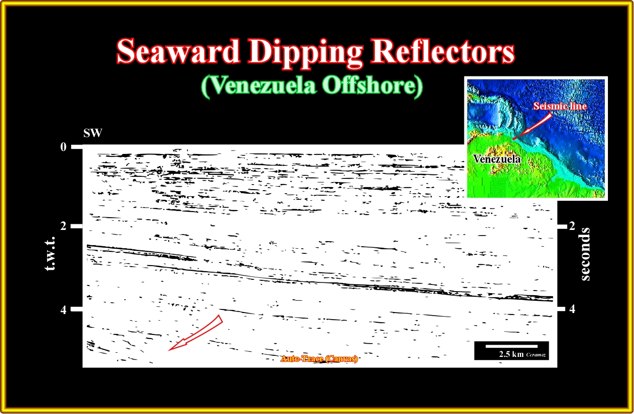
Plate A18.03- Not far from the previous line, the SDRs are, also, easily recognized, as well as the maximum flood surface (downlap surface) that separates the transgressive and regressive phases of the margin.
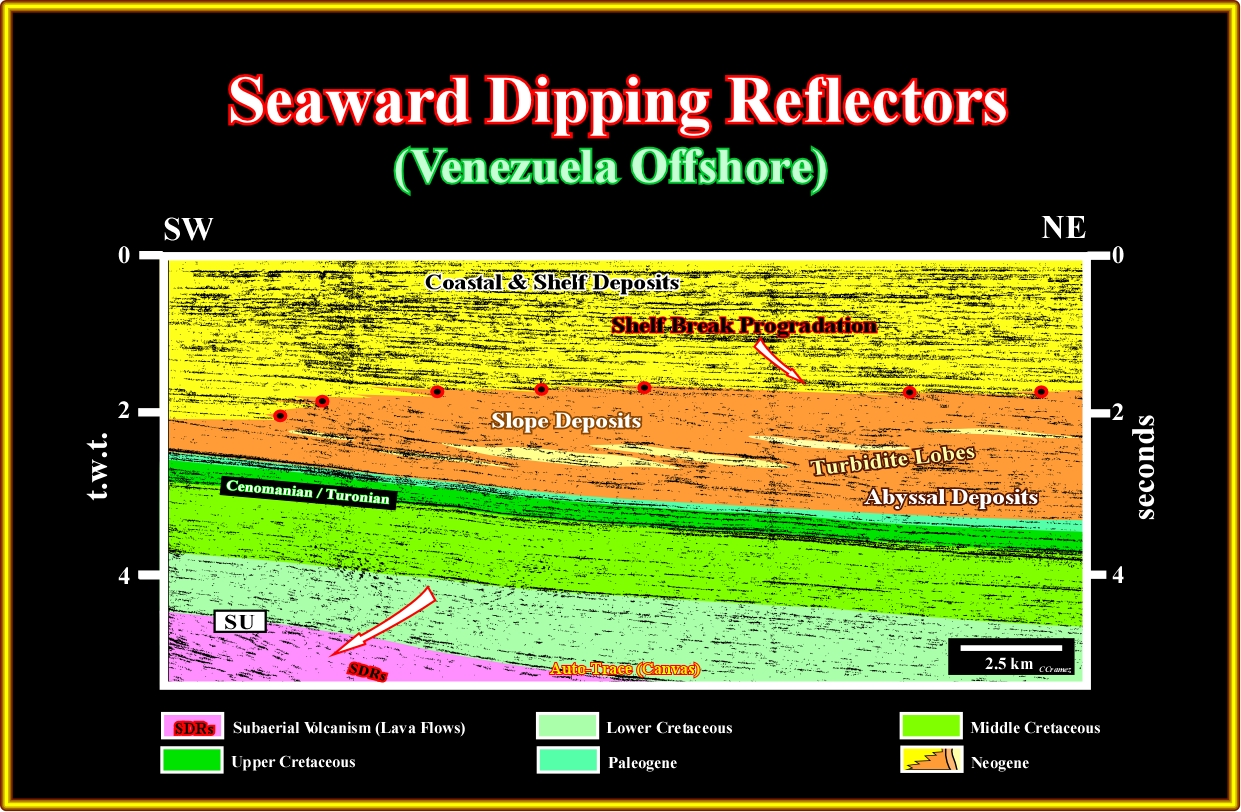
Plate A18.04- Obviously, this seismic line was not shot to recognize the SDRs, which are visible in lower left part of the line (below the SU unconformity), but to out in evidence the turbidite lobes (shingled turbidites) visible at the bottom of the slope progradations, which can be considered as potential traps (morphological traps).
A19- USA Offshore (Gulf of Mexico):
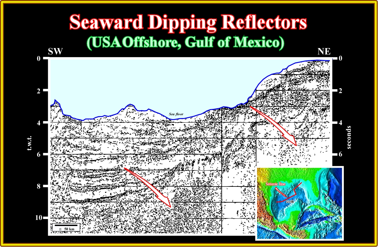
Plate A19.01- This composite seismic line across the Gulf of Mexico corroborates the hypothesis of a volcanic-margin type of opening for the Gulf. In fact, there is a strong evidence of volcanic structures, which lateral succession suggests a progressive drowning of the spreading centres.
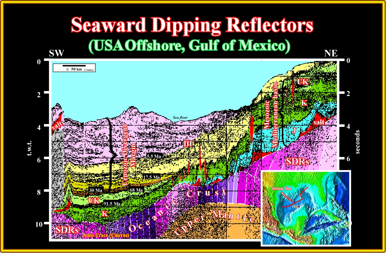
Plate A19.02 On this tentative interpretation the transition of the subaerial crust (SDRs) to the oceanic crust (sheeted dykes) is quite plausible. Above the volcanic crust it is easily to recognize a Mesozoic Mediterranean-type basin overlain by a Cenozoic divergent margin. In the middle of the seismic line, the distal part of the deepwater Mississippi fan is obvious to the eye.
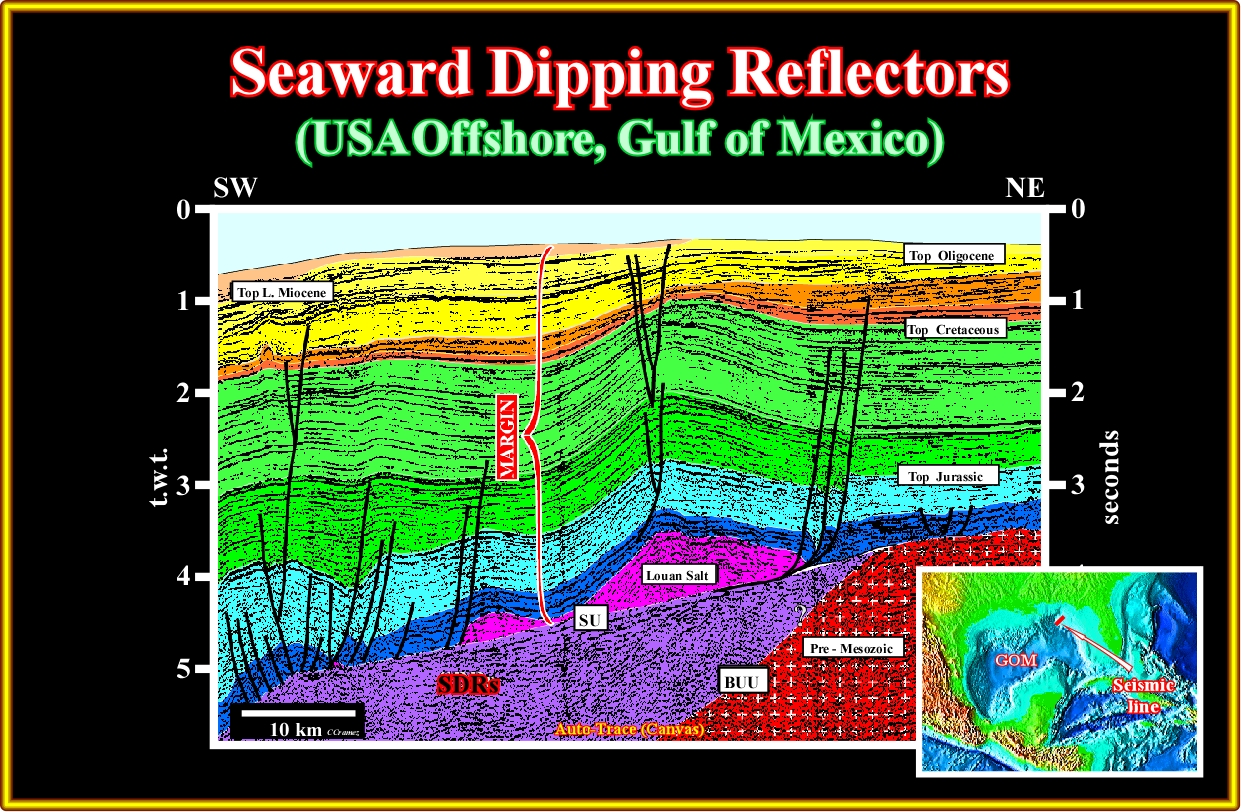
Plate A19.03- In 70's, the SDRs recognized in this seismic line were interpreted as Triassic rift-type basin until the well's result indicate a volcanic facies. On the other hand, as illustrated next, the new seismic data display all characteristics of the subaerial lava flows.
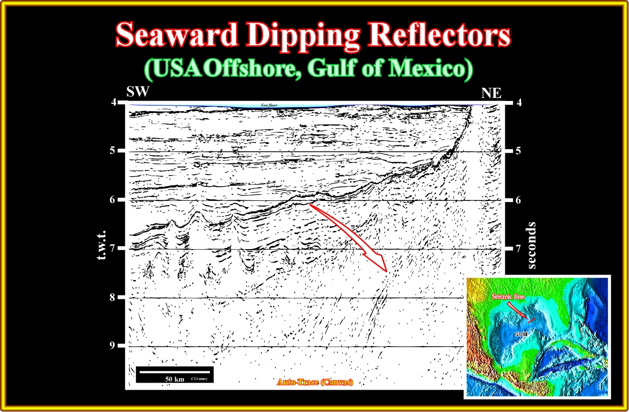
Plate A19.04- On this seismic line located seaward of the previous one, below the evaporitic interval, which underline the breakup unconformity, not only the seaward dipping reflectors are obvious, but lava-deltas as well.
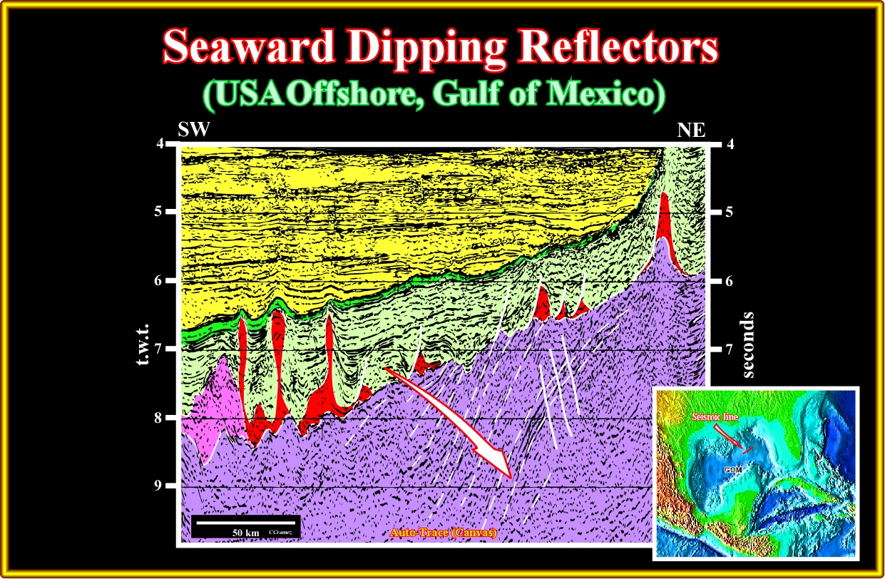
Plate A19.05- In this tentative interpretation of the previous line, the seaward dipping reflectors, that is to say, the subaerial lava flows are evident. Similarly, few lava-deltas are visible in the centre of the line. In fact, lava-deltas form wherever subaerial flows of lava enter standing bodies of water; the lava cools and breaks up as it encounters the water, with the resulting fragments filling in the seabed topography such that the subaerial flow can move further offshore. Be aware of the explosive volcanism (in rose on this tentative), that, in this line, seems to halt the downdip displacement of evaporitic interval.
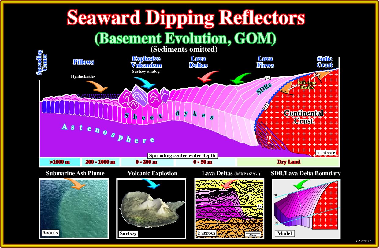
Plate A19.06- As here depicted, it seems that different volcanic structures are formed function of the water depth. of the spreading centres. In dry land only the more distal (far away of the spreading centres) are generally recognized. When the spreading centre is under a water depth ranging between 0 and 50 meters, that is to say, when the spreading is subaerial, SDRs are predominant, but lava deltas are likely. Seaward, when the spreading centre is under 0-200 meters of water, explosive volcanism can occur. Since the water depth is higher than 200 meters oceanic crust predominates with local deposition of the hyaloclastics derived from the explosive volcanism.
A20- USA Offshore (Virginia Offshore):
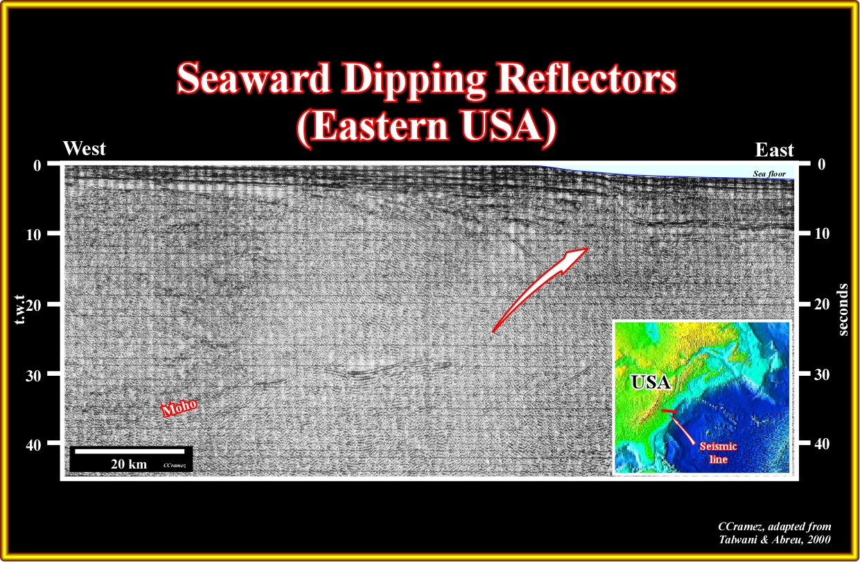
Plate A20.01- On this regional seismic line of the Virginia offshore, not far from the Baltimore Canyon, large seaward dipping reflectors are recognized, as depicted below.
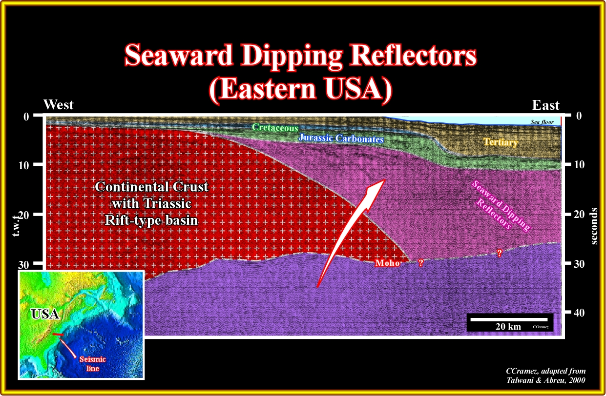
Plate A20.02- This tentative interpretation of the previous seismic line strongly suggests that the USA Atlantic margin is a typical volcanic margin, contrariwise to what was though before (under the influence of the interpretation of the Galicia offshore proposed several European geoscientists). In fact, as depicted, the substratum of the margin sediments is essentially composed by seaward dipping reflectors, which fossilize the breakup unconformity. Take notice that in this tentative, the continental crust include the Triassic rift-type basins developed during the lengthening of the Pangea, which foreshadows the breakup of the lithosphere.
A21- USA Offshore (Baltimore Canyon):
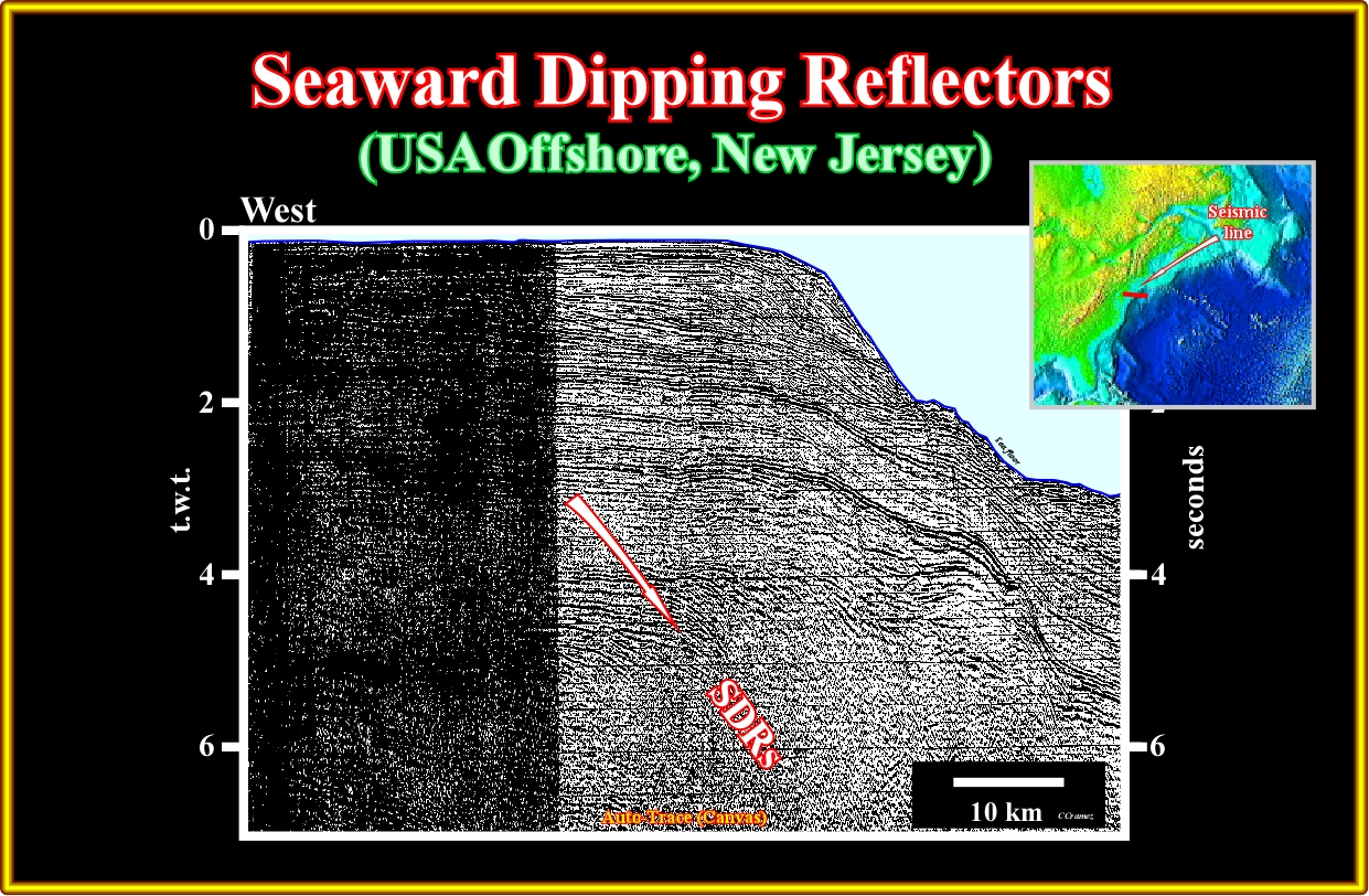
Plate A21.01- In the Baltimore Canyon area, as illustrated on this seismic line, the seaward dipping reflectors (SDRs) are known since several oil companies explore this offshore. They are well developed seaward of large Triassic rift-type basin, which eastward border is hard to see on this line, but not in the next one.
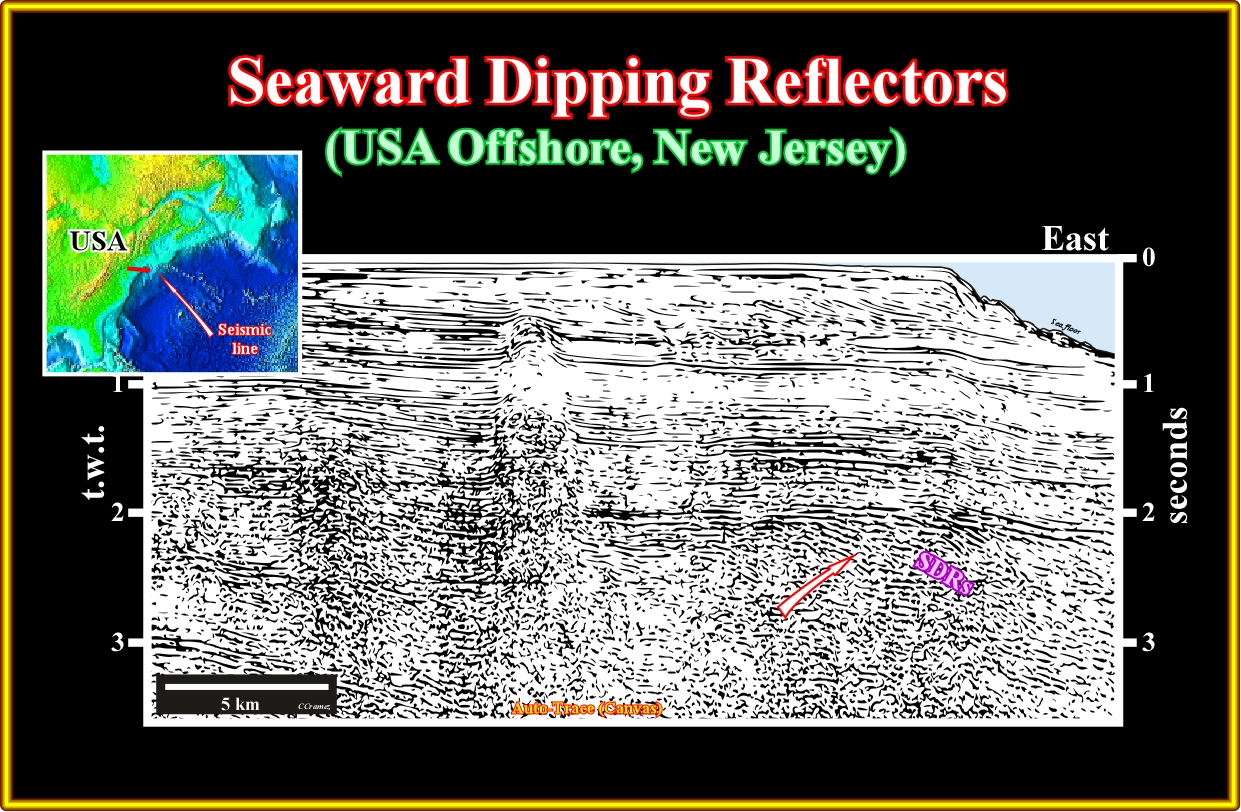
Plate A21.02- On this seismic line, more or less parallel to the previous one, not only the seaward dipping reflectors are obvious (in eastern part of the line), but the Triassic rift-type basin as well. A salt diapir is visible in the middle of the line .Notice in the upper part of the line the downlap surface, which separates the stratigraphic phases (transgressive and regressive) of the continental encroachment post-Pangea stratigraphic cycle.
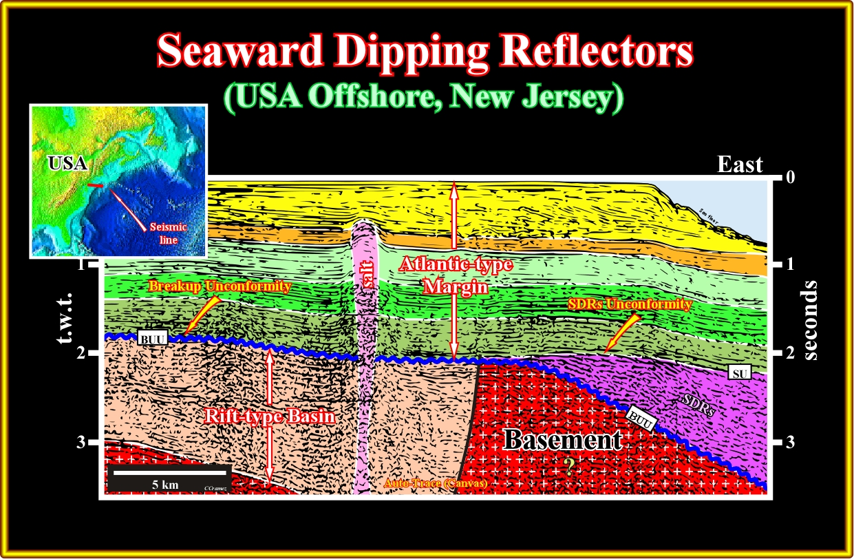
Plate A21.03- On this tentative interpretation of the previous seismic line, the picking of the breakup unconformity (BUU) is obvious. The SDRs are bounded between the BUU and SU unconformity. The normal fault bordering the Triassic rift-type basin is easily picked. The upper limit of then rift-type basin is the breakup unconformity. The salt diapir allow us to infer the presence of a mobile evaporitic layer within the rift-type basin.
A22- Canada Offshore (Nova Scotia Offshore):
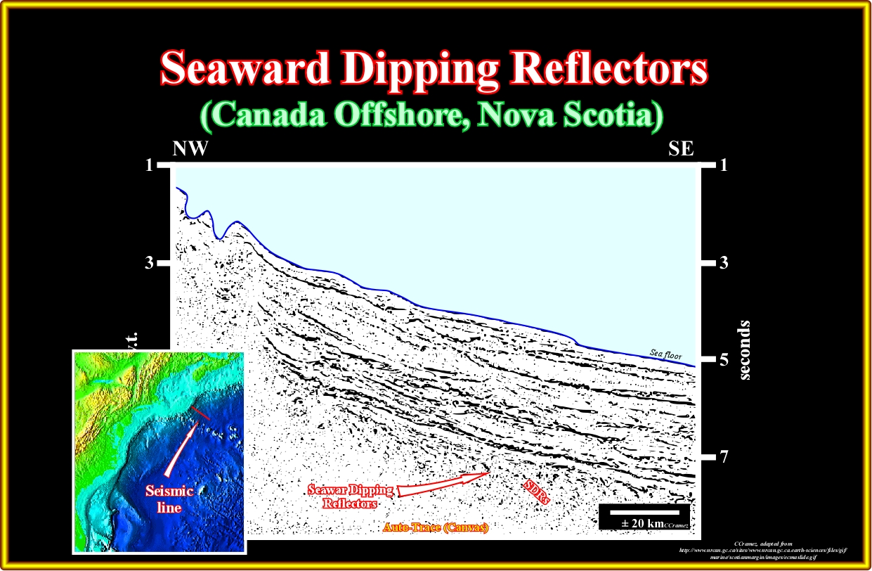
Plate A22.01- This seismic line has been used by several geoscientists to suggest the occurrence of the SDRs in Nova Scotia offshore. In other words, there is a strong probability that the Nova Scotia offshore corresponds to a volcanic margin.
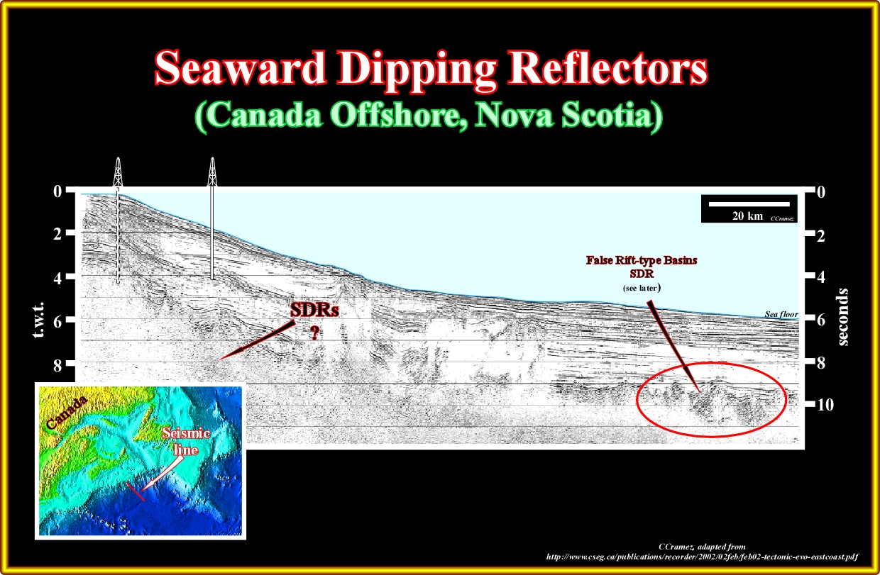
Plate A22.02- Northward of the previous seismic line, where large regional line were shot, as the one illustrated in this plate, the presence of a thick evaporitic layer and an active halokinesis makes difficult to decide if the margin is volcanic or non-volcanic. In the eastern part of this line SDRs are possible, but with a big question mark. On the contrary, Seaward of the of the salt deposition, there are reflectors dipping landward that can correspond to subaerial lava flows affected or associated to a normal faulting with a seaward vergence ( see Baffin Bay and Greenland offshore)
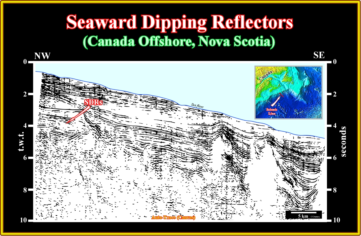
Plate A22.03- Assuming that the Nova Scotia Atlantic-type margin is volcanic (conjecture priori), this seismic line can be tentatively interpreted as illustrated in the next plate.
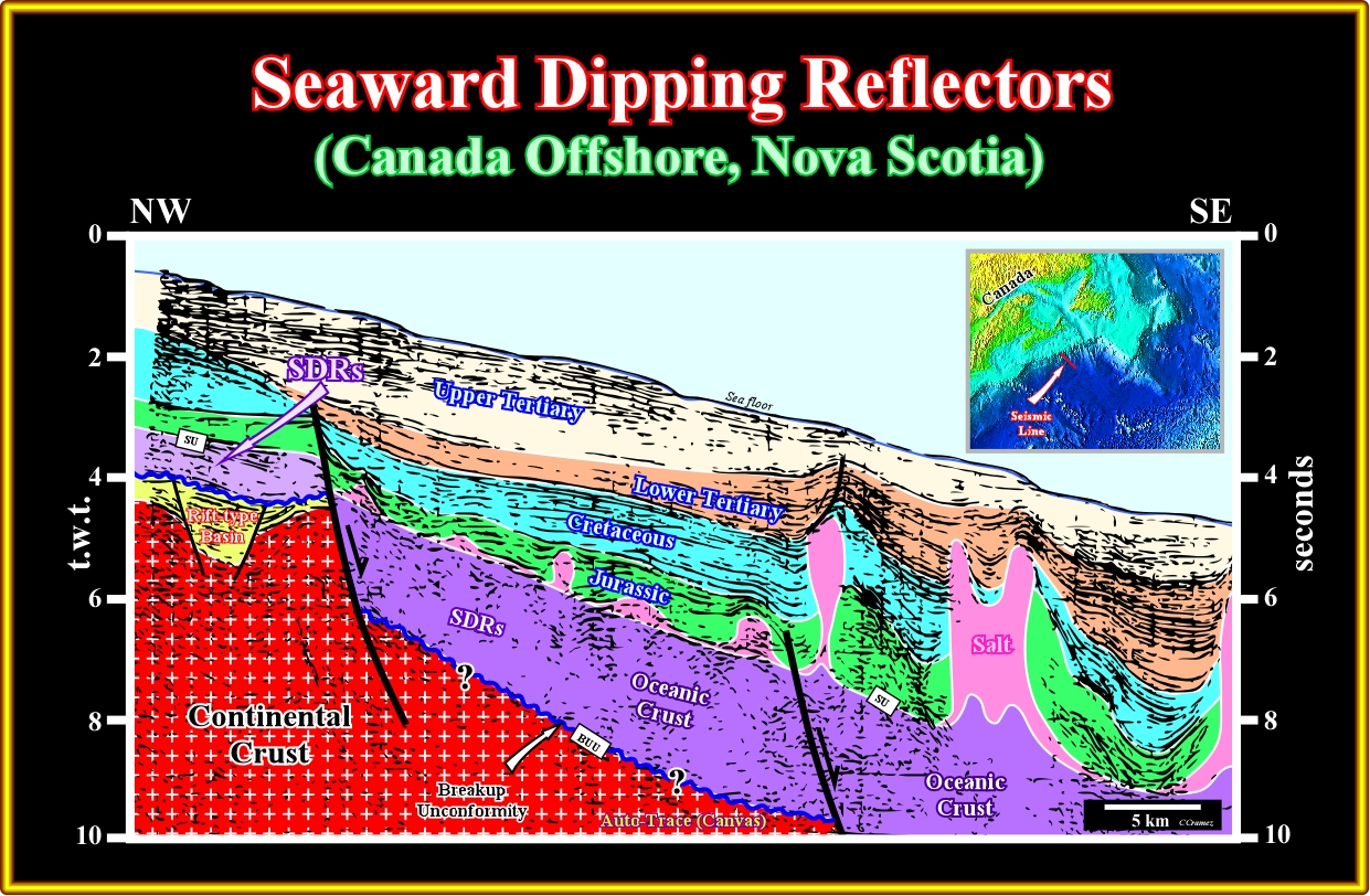
Plate A22.04- As said above, this tentative interpretation of the previous seismic line was made assuming that the margin is volcanic. It looks coherent, but it must be tested by other data. In fact, below the evaporite the interpretation is highly speculative. On the contrary, the presence of SDRs overlying the rift-type basin is the western end of the line looks likely.
Plate A22.05- On this seismic line of the same area than the previous one, the problem is the same, that is to say the interpretation of the evaporitic layer and overlying sediments is quite simple. However, the interpretation of the infrasalt interval can only be speculative are done b
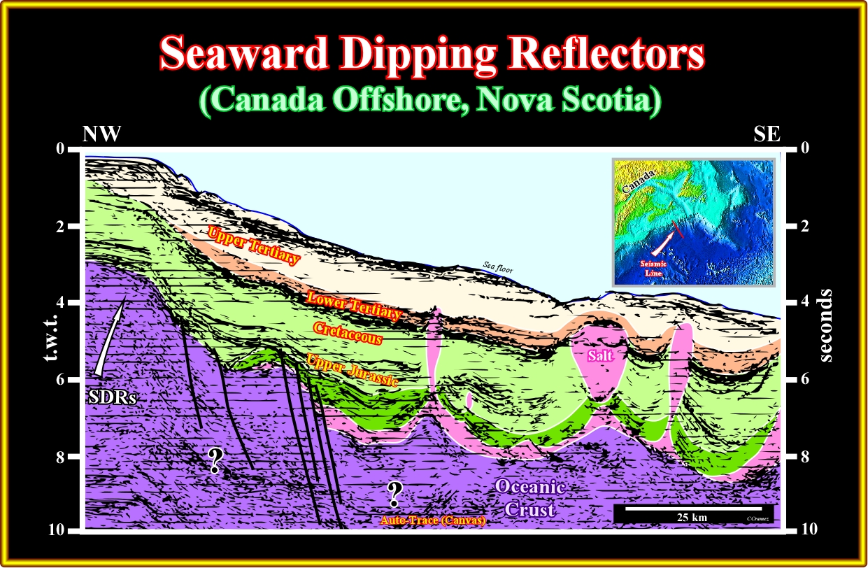
Plate A22.06- On this tentative geological interpretation, the more likely substratum of the margin sediments is volcanic crust. Obviously, subaerial lava flows are more likely in the western part of and the oceanic crust in the eastern part.
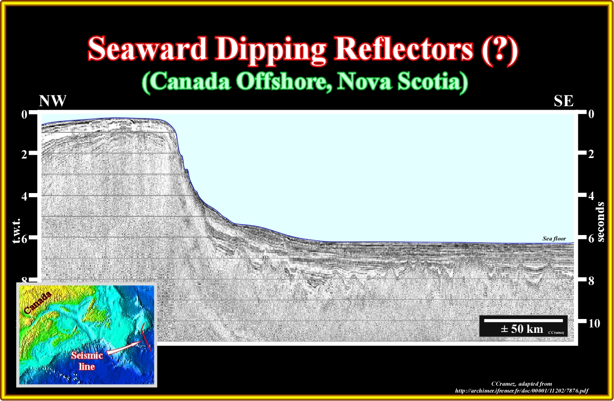
Plate A22.07- This seismic line is often used to prove that the southern part of the Flemish Cap is a non-volcanic divergent margin. The problem is that a tentative interpretation of a seismic line is dependent of the geological knowledge and expectation of the interpreter, since there is not objective interpretations in the Hume's sense ("tabula rasa"). In the same token, objective descriptions doesn't exist since language is not objective. In fact, if a geoscientist doesn't know what is looking never find it. On the contrary, when a geoscientist knows what he is looking for, he should not try to verify it but refuting it, what is completely different. The interpretation of this line illustrated next is a good example of verificationism and not criticism.
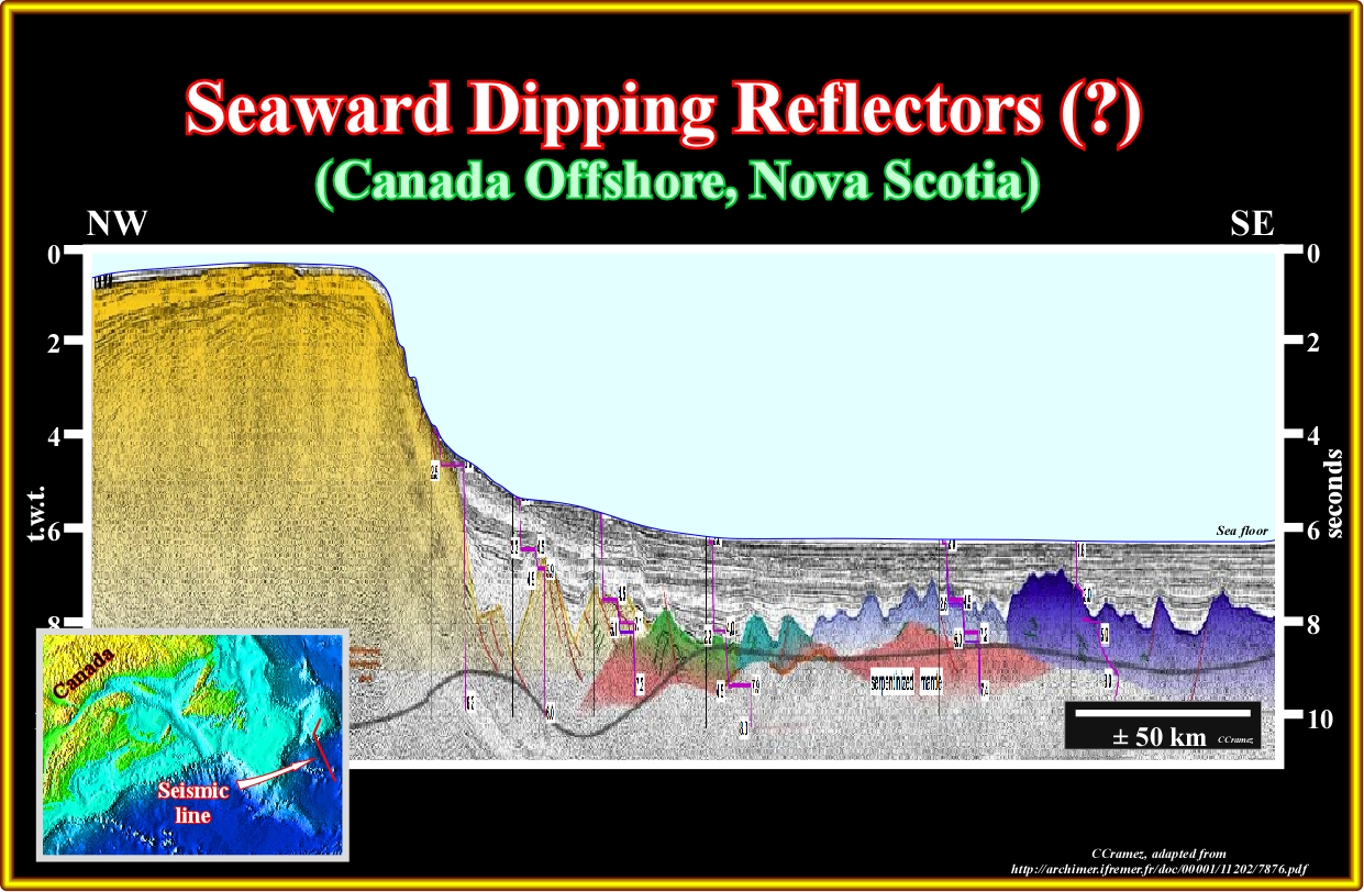
Plate A22.08- On this tentative interpretation, using the 1992 Erable multichannel seismic reflection experiment extending from the southeastern margin of Flemish Cap into the northern Newfoundland Basin, the interpreters tried to impose the geological model used in Galicia offshore. Subsequently, exhumed serpentinized mantle (in green) deep serpentinized mantle (in orange), thin oceanic crust (light blue), normal oceanic rust (dark blue) and stretched continental crust (yellow) become, according to them, evident using projected velocity profiles and a time converted Moho (see the above uninterpreted line), and so to, in a circular way, the geological model is verified (unfortunately in science models can only be refuted and never verified).
A23- Canada Offshore (Labrador offshore):
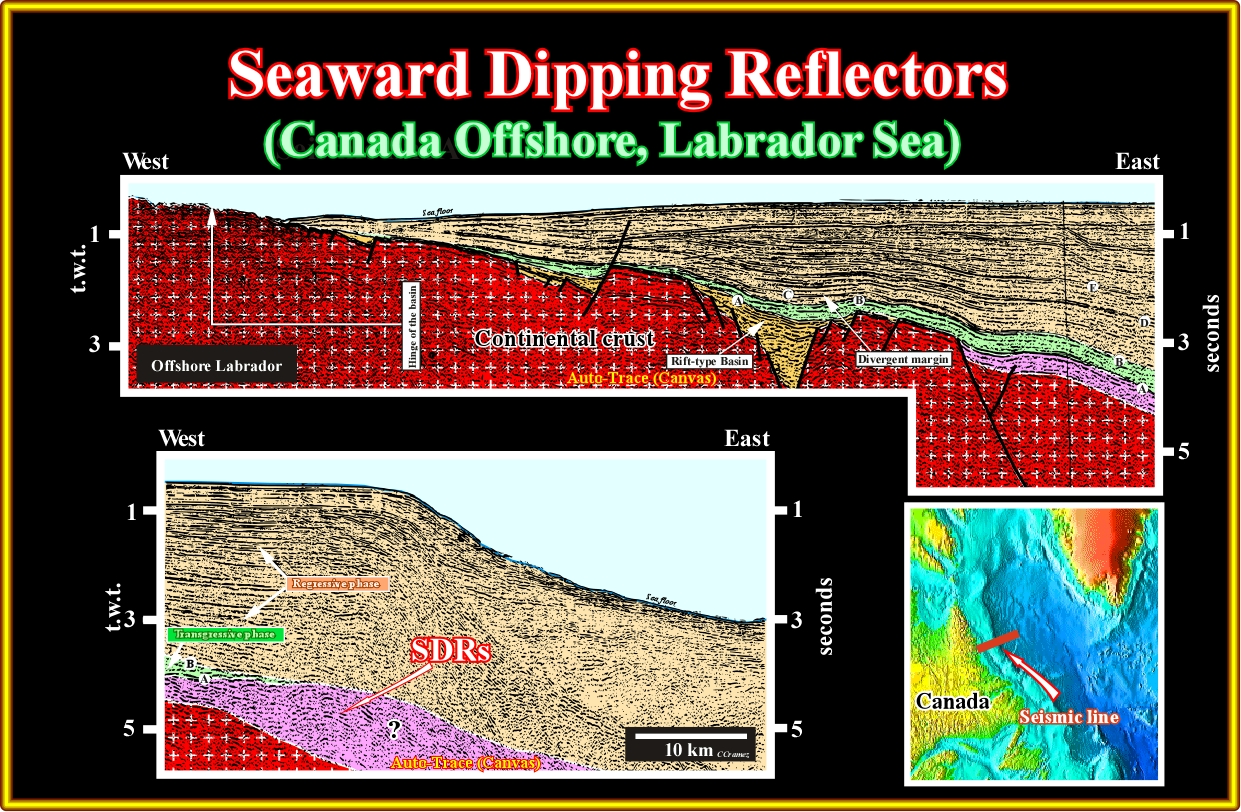
Plate A23.01- In the Labrador Sea,as suggested in this tentative interpretation, the SDRs are likely at the end of this regional seismic, which is corroborate by other lines, in which the presence of SDRs is more evident, as illustrated next.
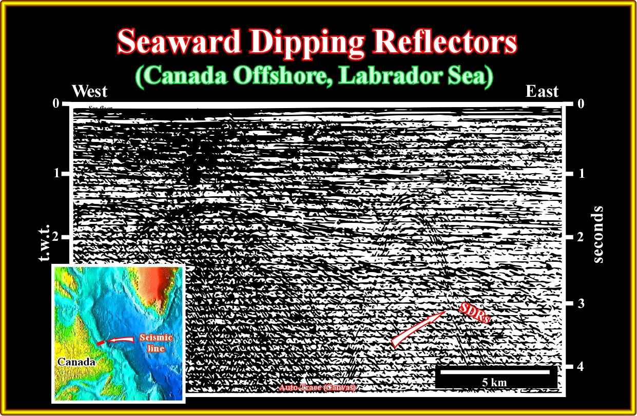
Plate A23.02- In this seismic line, it is easy to recognize the basement (supracrustal rocks), the seaward dipping reflectors and the overlying transgressive sediments of the post-Pangea continental encroachment stratigraphic cycle.
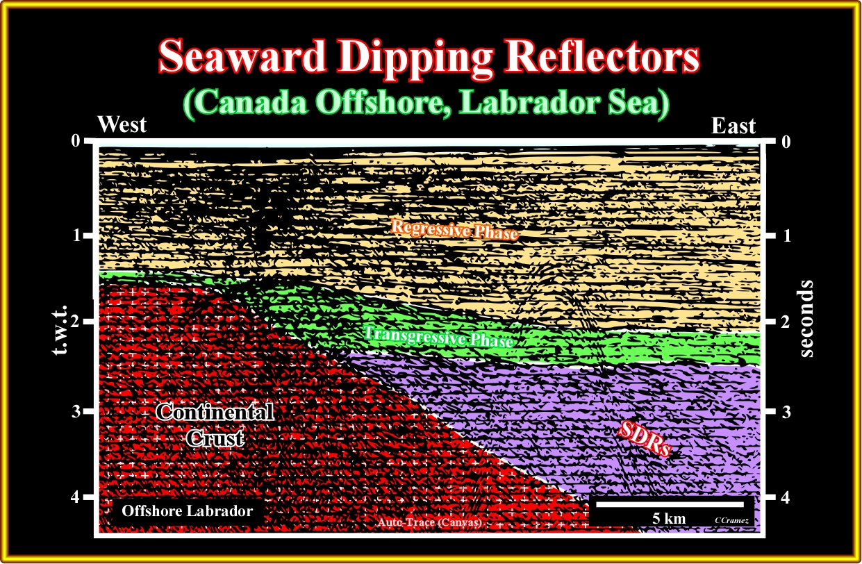
Plate A23.03- This tentative interpretation is by far the more plausible. In fact taking into account the global geological context of this offshore and the adjacent Offshores (Baffin Bay and Western Greenland) nobody doubts that the Labrador continental margin is a volcanic. As a curiosity take note that the diffractions in the middle eastern part of the line were induced by the presence of an iceberg at the time of the shooting.
A24- Canada Offshore (Baffin Bay Offshore):
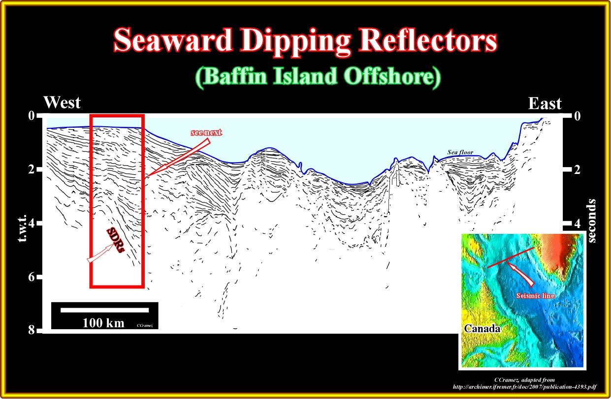
Plate A24.01- Northward of the Labrador Sea in the Baffin Bay area the presence of SDRs is well know since longtime as illustrated in this tentative interpretation of a mega regional line between Baffin Bay and West Greenland offshore.
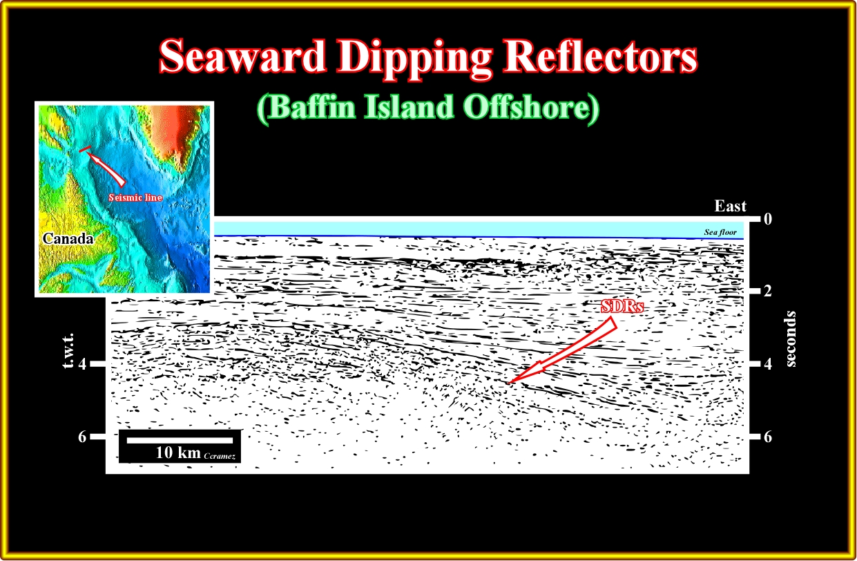
Plate A24.02- In this seismic line located near the western end of the previous mega-regional line, the subaerial lava flows show a typical seaward tilting, In the western Greenland offshore, the SDRs are well known. However, in this offshore, they are affected by a normal faulting, which sometimes seems synchronous of the deposition of the lava flows, as illustrated in the next plate.
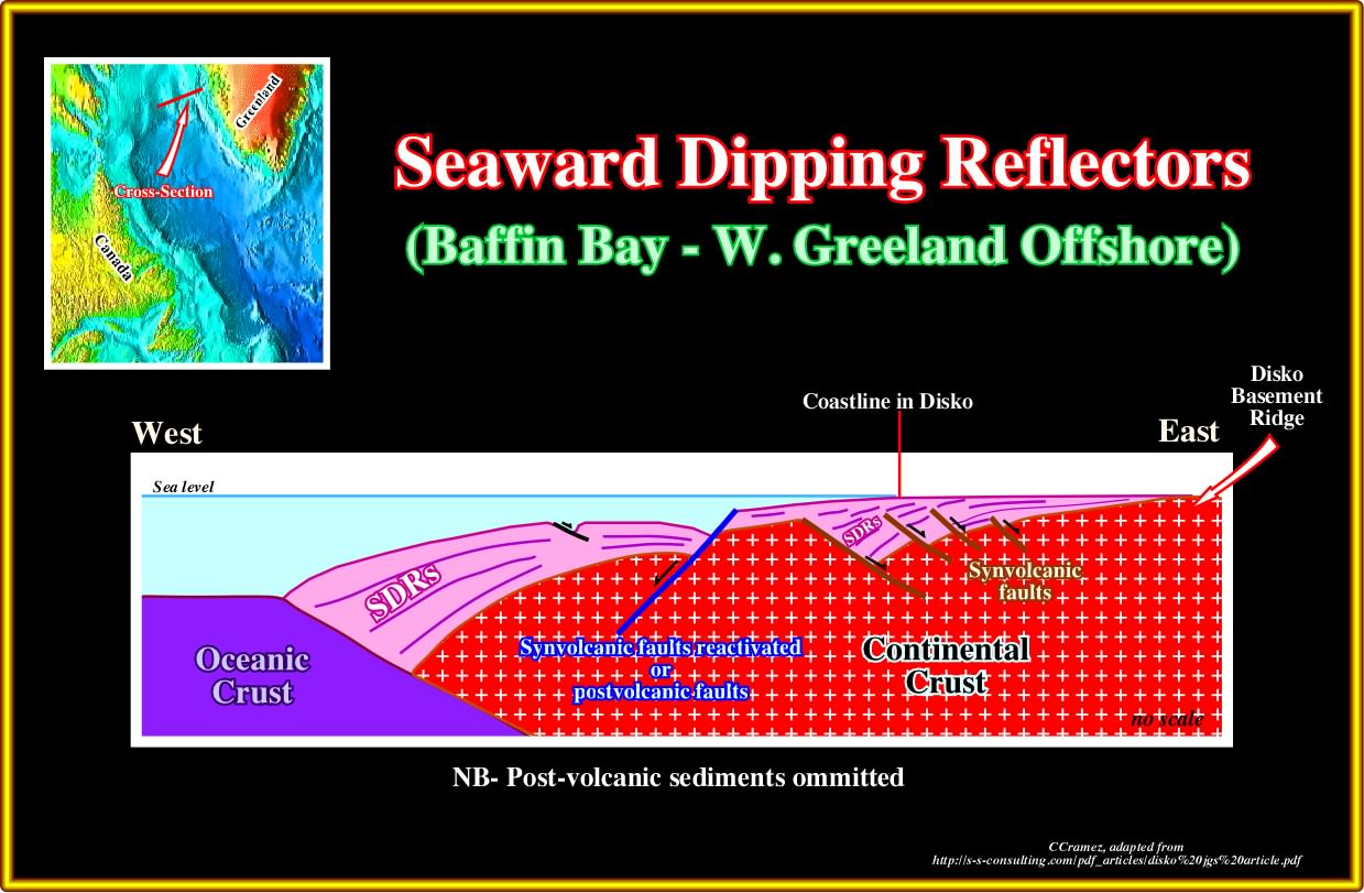
Plate A24.03- In this schematic model of the SDRs in the onshore and proximal offshore of the western Greenland the SDRs, which globally thin landward can infill small half-graben with a seaward vergence( the normal faults bordering the half grabens dip landward.
A25- Denmark Offshore (W. Greenland Offshore):
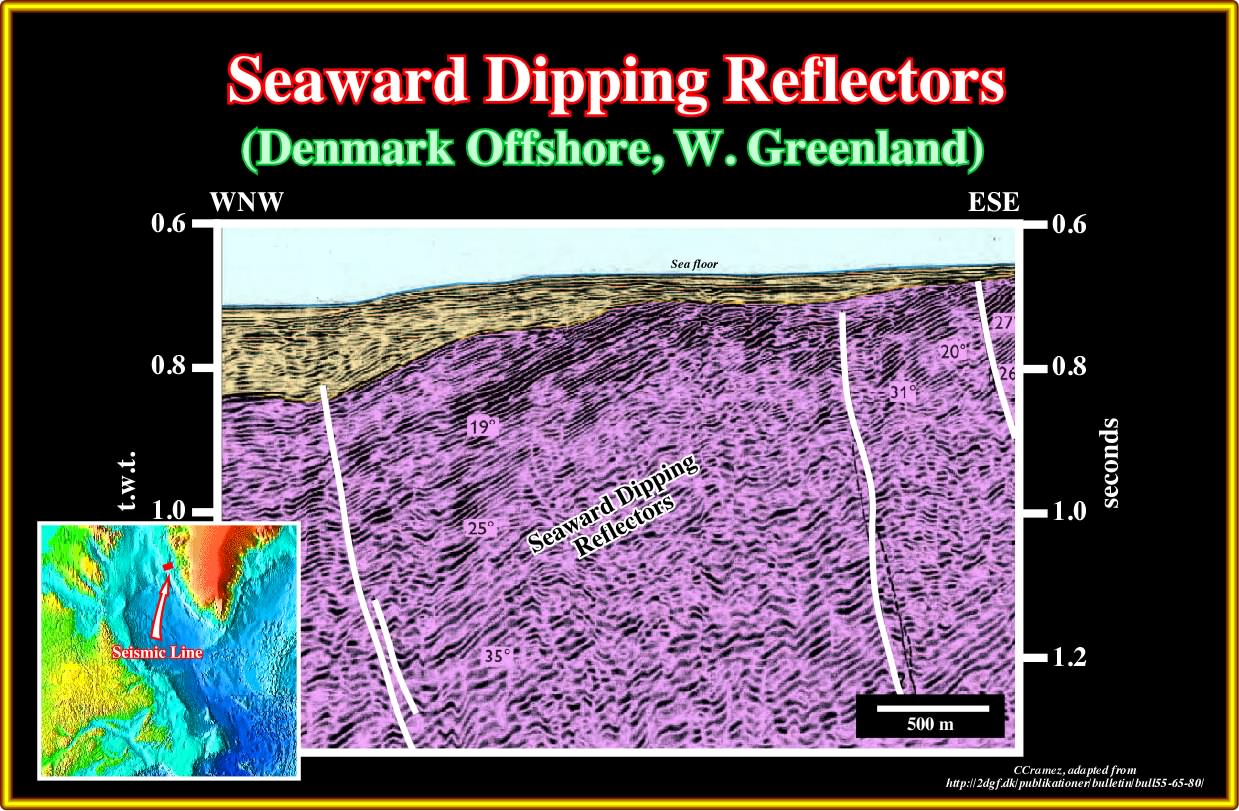
Plate A25.01- As illustrated in this seismic line of the conventional offshore of West Greenland, the dip of the SDRs increase in depth suggesting that is the loading of the younger lava flows the principal responsible of the Seaward tilting.
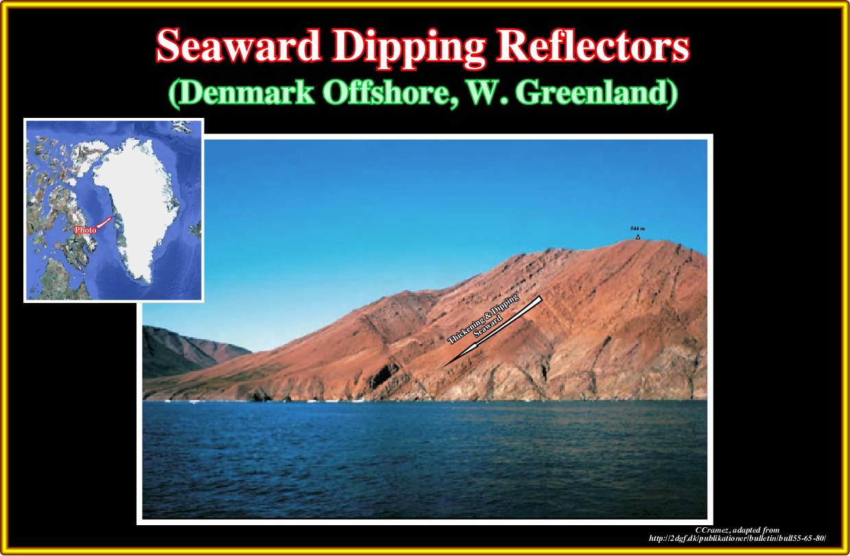
Plate A25.02- The seaward dipping reflectors (subaerial lava flows) outcrop in western shoreline of Greenland as illustrated on this photo taken from a well known scientific publication.
Plate A25.03- Initially, that is to say, in the 90's, naive seismic interpreters forgetting completely the regional geological context of the area, recognize in this seismic line rift-type basin. Such interpretation was immediately refuted by those knowing the geological context of the area, who, generally, adopt an hypothetical-deductive approach (Problem-Hypothesis-Test) in the interpretation of the seismic lines, as illustrated next.
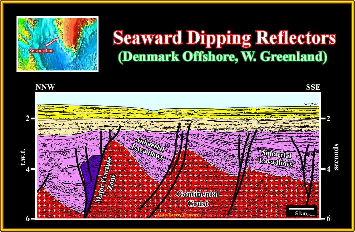
Plate A25.04- In this tentative interpretation of the previous line, the normal faults are synchronous or postdate the deposition of the subaerial lava flows. The facies of the dipping reflectors is volcanic. On the other, the half-grabens are not rift type basin developed during the lengthening of the continental crust predating the breakup of the lithosphere. Here the breakup took place before the deposition of the SDRs, in a context of strong mantle activity, which induce a post breakup lengthening (see Plate A25.08).
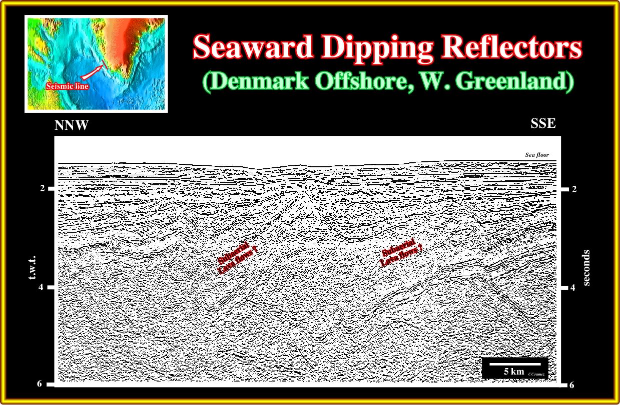
Plate A25.05- In this seismic line parallel and located not far from the previous one, the dip of the subaerial lava flows, as well as the dip of the normal faults are in opposite bearing. Such a feature, as often explained by A. Bally and other geoscientists, just means that a transfer fault (fracture zone) between the seismic line delimits two different provinces.
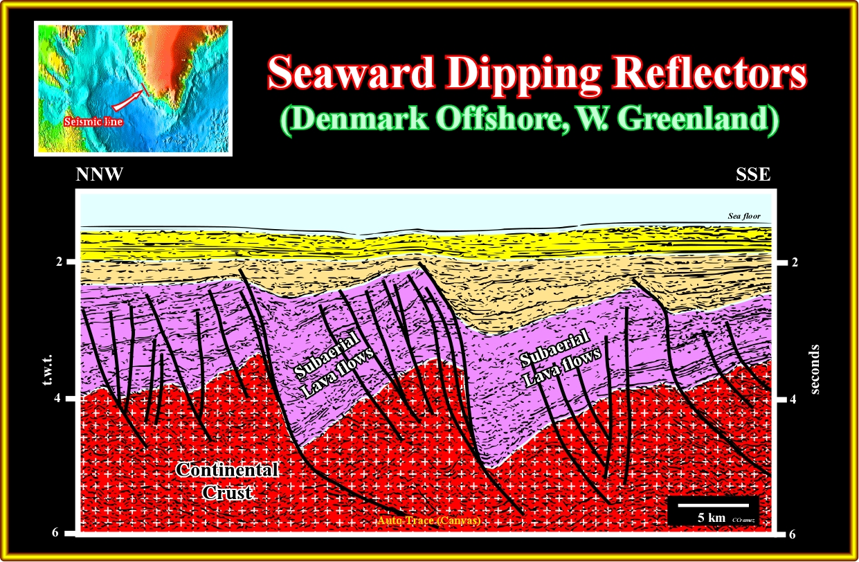
Plate A25.06- This tentative interpretation, as the tentative interpretation of the seismic line illustrated in plate A25.03, not only show that the half graben a false rift-type basin, but the lengthening of the continental crust (SDRs and margin sediments), that is to say, the mantle activity proceed after the deposition of the SDRs (see Plate A25.08).
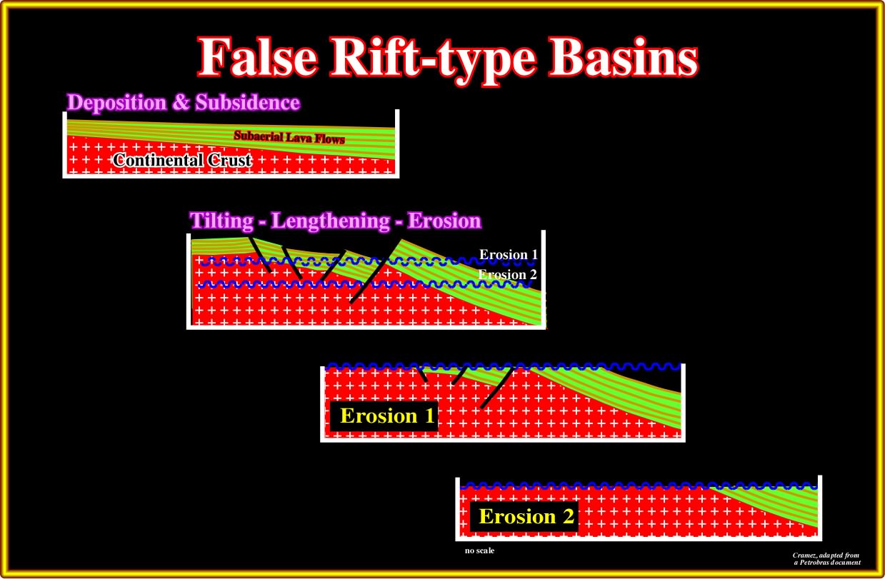
Plate A25.07- As said previously (Brazil offshore, Pelotas basin), the Brazilian geoscientist explain the false rift-type basins recognized in Pelotas offshore as a consequence of deposition, tilting (lengthening, i.e., formation normal faults) and erosion of the subaerial lava flows. As here illustrated, if the level of erosion near the hinge zone (change of dip) is to deep, the normal faults allowing the lengthening are not more visible.
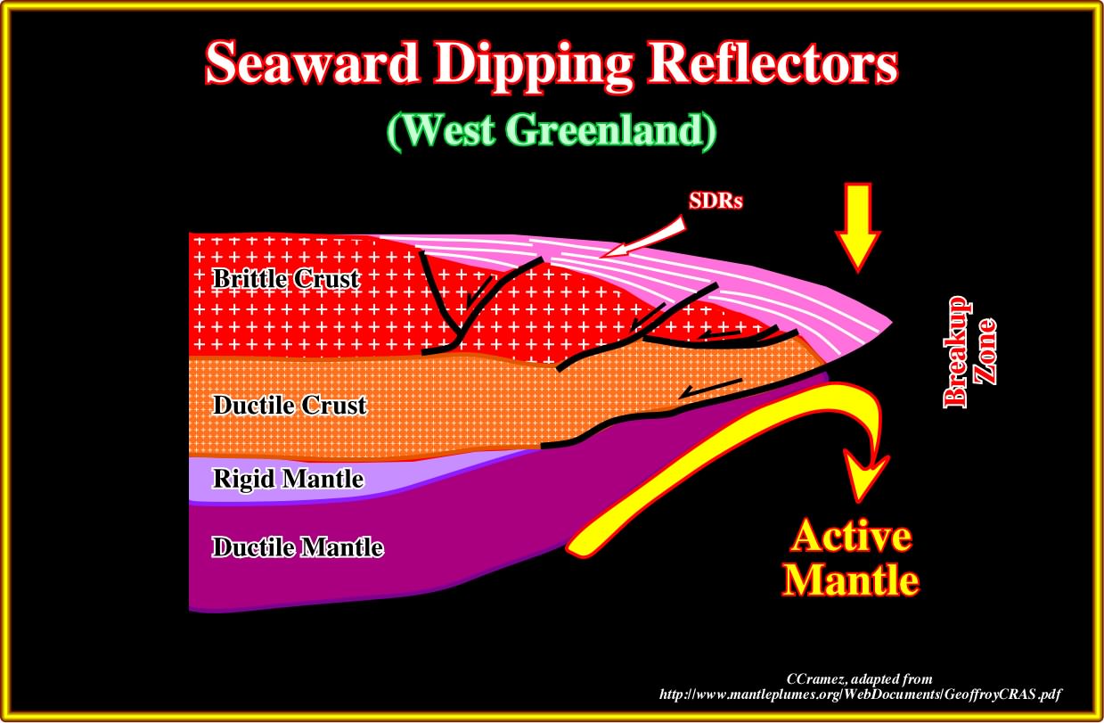
Plate A25.08- Certain geoscientists explain the subaerial lava flows and particularly the formation of the half-graben in North Atlantic as a consequence of a strong mantle activity (inward convection motion), which induces a lengthening of the crust (mainly of the upper brittle crust) by normal faults, generally looking toward the continent, even after the breakup of the lithosphere, that is to say, during and after the deposition of the SDRs.
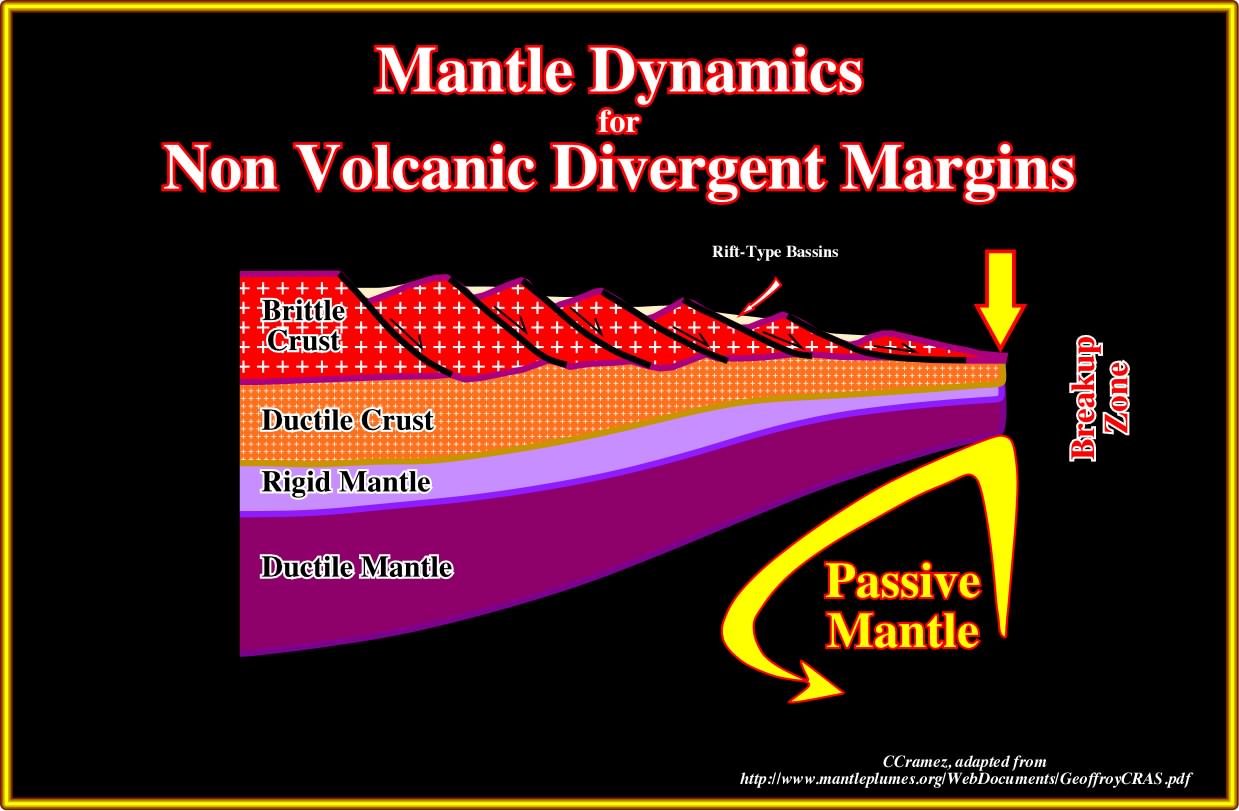
Plate A25.09- By contrast the geoscientists assume that in a non-volcanic continental margins, as it seems be the case in Galicia and Flemish Cap, the absence of subaerial lava flows and strong lengthening of the lithosphere over a detachment surface, the mantle is passive (outward convention motion). Nevertheless the reason, in the Atlantic-type margins, that is to say, in the divergent margins developed in association with the breakup of the Pangea, as one can find out on the next plates, only the Galicia offshore and eventually the area of Flemish Cap can be considered as non-volcanic.
to continue press
next

Send E-mail to carloscramez@gmail.com with questions or comments about these notes (Altlantic-type Divergent Continental Margins).
Copyright © 2012 CCramez
Last modification: July, 2014