
Universidade Fernando Pessoa
Porto, Portugal
Geological Setting & Seismic Interpretation
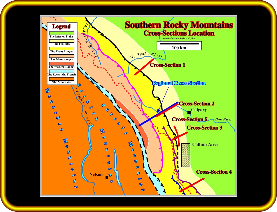
Plate 18 - On this map are located the cross-sections illustrated on the next plates. All these cross-sections were taken from Bally et al. 1966 (Structure, Seismic Data, and Orogenic Evolution of Southern Canadian Rocky Mountains). The regional cross-section (in blue) crosses the Foothills, the Front Ranges, the Main Ranges and the Western Ranges. The others are much shorter. They illustrate the Foothills and the eastern part of the Front Ranges. The areaof interest is located between cross-section 3 and 4.

Plate 19 - The Paleozoic carbonate skeleton consists of a several thrust sheets. Overlying the Paleozoic carbonates there is an envelope of complex Mesozoic imbrications. Most should be considered as being sheared off the top of the lower sheet by the higher Moose Mountain sheet. Actually, the thrust displacement of the Cardium for instance often greatly exceeds the slip shown for the underlying frontal sheets. This implies that the Moose Mountain sheet sheared off Mesozoic beds off their carbonate substratum before the more easterly lower thrust sheet was formed (see plate 20).
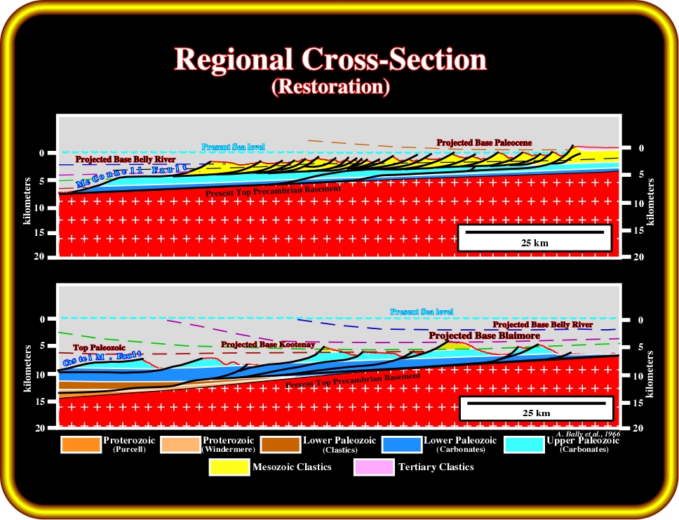
Plate 20 - Each imbrication and thrust sheet is shown in its present and restored position. Offsets in the line of the section are disregarded, and for ease of construction the restoration is tied to the present basement gradient, whereas to the west a non specific datum is assumed. Note that nowhere in the structure section or in its restoration is the Paleozoic section completely missing. The authors assumed that no major structural units have been removed by erosion. They calculate a shortening in the order of 50%, or about 160 km for the Main Ranges.
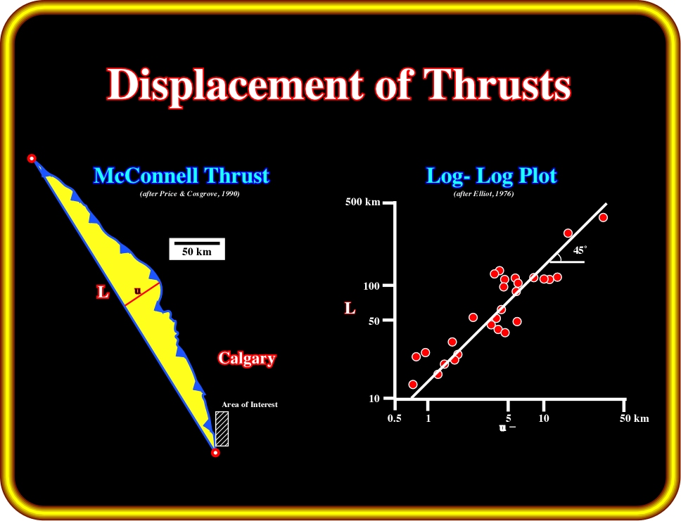
Plate 21 - Thrusts, such as the McConnell thrust, often crop out along a well defined arcuate-form. Such a geometry can be linked to a bow and the movement direction and displacement (which reaches its maximum at the center of the bow) to an arrow. It can be demonstrated that there is a systematic relationship between the length of the ‘bow string’ and the displacement ‘arrow’. For Rocky Mountain thrusts, as illustrated above, the maximum displacement (u) is 7% of the length (L) of the bow string between the extremities of the thrust (Price, 1990). The log-log plot of L against u for 29 thrusts in the Foothills and Front Ranges of the Canadian Rockies shows a slope that indicates a linear relationship of u=7% L.
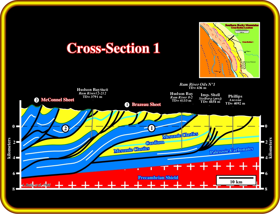
Plate 22 - This cross-section displays many characteristic features: (i) the basement dips gently to the west, (ii) faults tend to be steep at surface but they flatten out at depth, where they ultimately merge into bedding planes, (iii) in a westward direction faults always cut deeper into the section, (iv) the Cambrian is involved in the thrusting and forms the base of the Brazeau thrust sheet. As Paleozoic sheets do not lie “flush” on top of each other, much of the Mesozoic sequence is undisturbed and preserved below the Brazeau thrust sheet, i.e. few imbrications involve Mesozoic clastic rocks (see difference with cross-section 2).
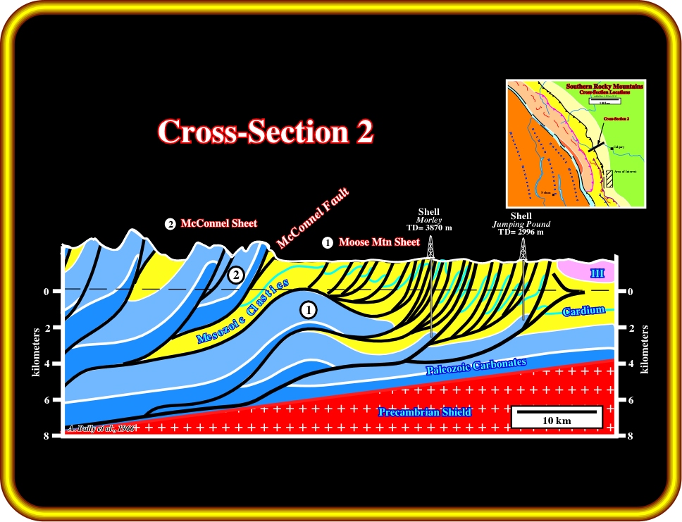
Plate 23 - This cross-section corresponds to the eastern end of the regional cross-section (fig. 19). The Paleozoic carbonate skeleton consists mainly of two sheets: The Moose Mountain sheet and the McConnell sheet. The lower one can be split into three parts: (i) the gas-bearing structures of the Jumping Pound and West Jumping - Pound - Morley, i.e. the frontal offshoots underlain by a common bedding fault and showing cumulative thrust slip of 5-6 km, (ii) an intermediate flat part of normal stratigraphic thickness that evidently conceals the displacement of the frontal offshoots in the form of a basal Mississippian bedding fault plane, and (iii) a rearward lens-like feature at the place where the bedding plane fault cuts into deeper Paleozoic strata, thus forming a broad anticline. Overlying the Paleozoic carbonate skeleton is an envelope of complex Mesozoic imbrications. It seems that the area marked by a multitude of Mesozoic imbrications indicates the presence of carbonate sheets stacked on top of each other without intervening Mesozoic clastic strata.
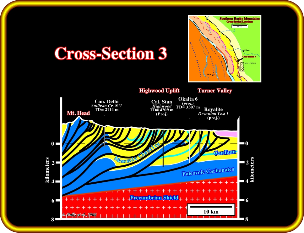
Plate 24 - This cross-section illustrates the structure of Turner Valley oil field. Compared with the previous cross-sections, we can observe elements of both structural styles, i.e. thrust sheets that override the relatively intact Mesozoic sequence, and thrust sheets that sheared off considerable amounts of Mesozoic strata from their substratum.
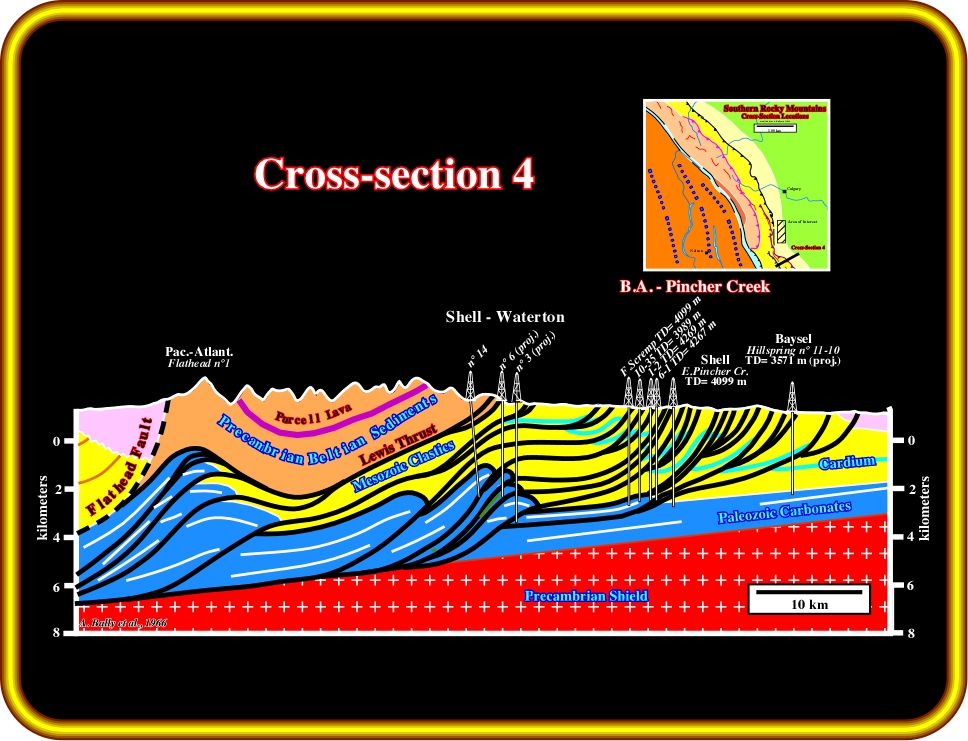
Plate 25 - This cross-section shows the imbrications overlying the Pincher Creek structures which are sheared off the top of the Waterton structure and strike parallel to that feature. Whether the Pincher Creek structure was formed prior to, or after, the deformation of the overlying Mesozoic imbrications, cannot be decided easily. However, elsewhere in the Foothills and Rockies, there is evidence suggesting that deformation progresses from west to east.
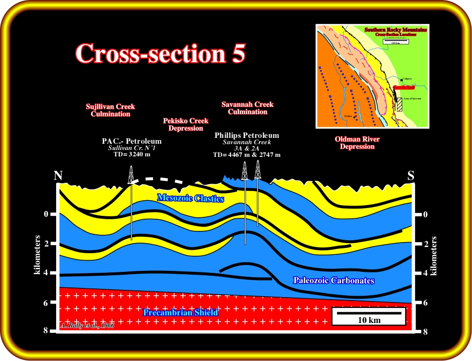
Fig. 26- This strike cross-section gives insight into the nature of the axial culminations and depressions in the Rockies. Clearly, there are no basement highs underlying the culmination, and basement depressions are also absent. The occurrence of axial culminations is due either to deeper imbrications and thrust sheets or to local variations in thickness of the stratigraphic sequence involved in the thrust sheet or else to a combination of both.

Plate 27 - The geological map illustrated on the next plate (Stockmall, 1966) is located on the southwestern part of the area of interest, as shown on this map.
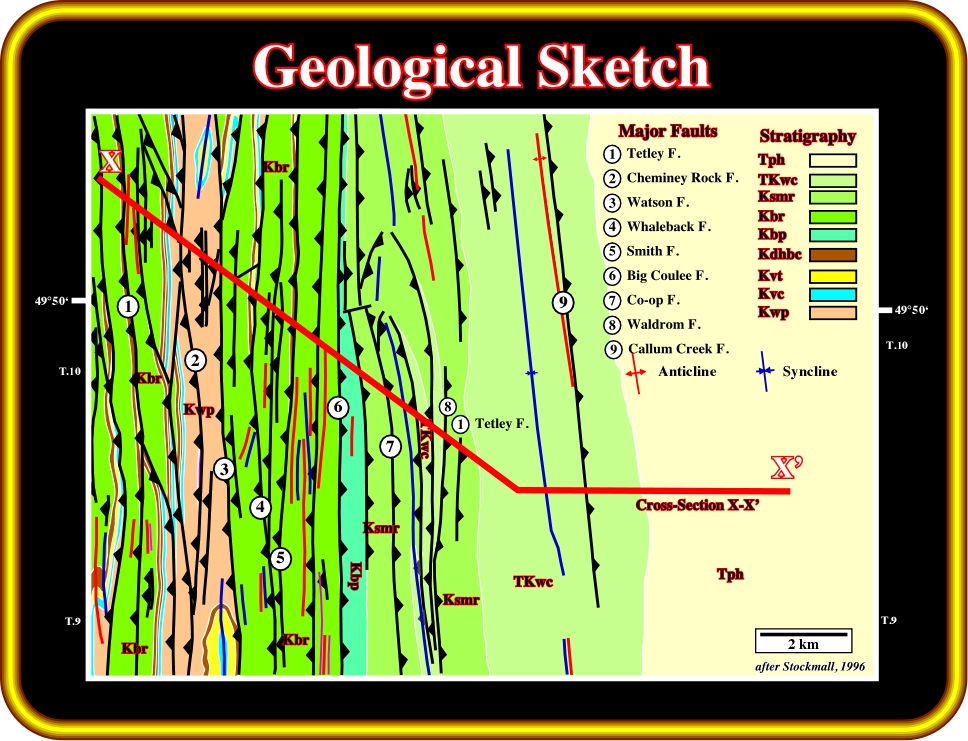
Plate 28 - This geological map indicates that the sediments were shortened by a compressional tectonic regime characterized by a
1 horizontal striking more or less W-E and a
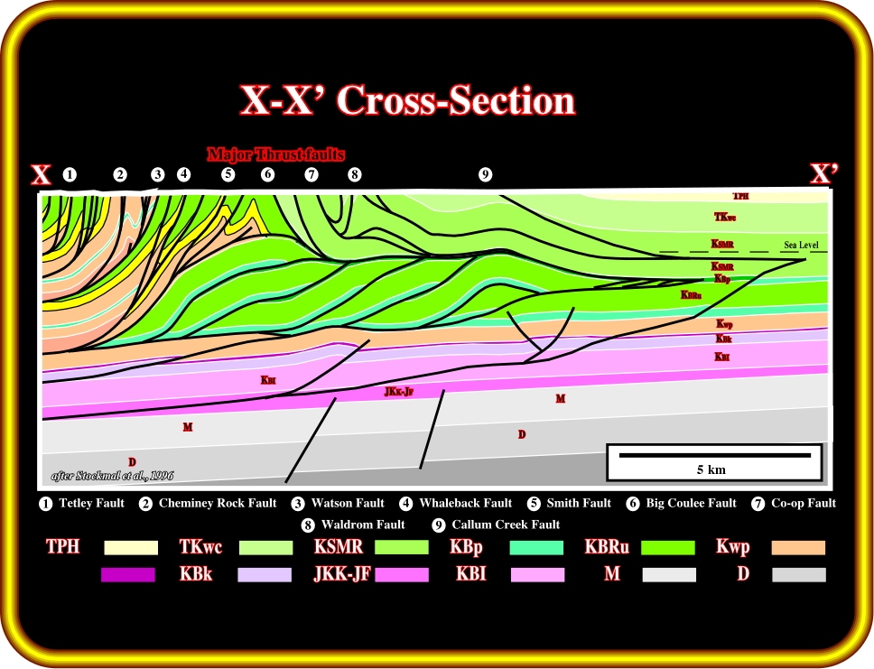
Plate 29 - This cross-section was already proposed by Shell in the 50‘s. Stockmall’s interpretation is quite different from the original (no Paleozoic extension and no duplexes). The Paleozoic sediments are lengthened, while the Mesozoic sediments are strongly shortened by thrust sheets and associated folds. A front fold detachment is proposed between the shortened and structurally thickened section of the Foothills and the normal stratigraphy of the Plains. As said previously, the regional dip of the Plains is westward, as well as in the Foothills. These two areas are connected by a short panel of east dips producing an anticlinorium overlying stacked imbrications created by a bulldozer effect of the western sheet thrusts.
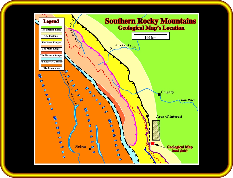
Plate 30 - The geological map illustrated on the next plate (Jerykievicz and Norris, 1994), is located southward of the area of interest, as shown on this map.
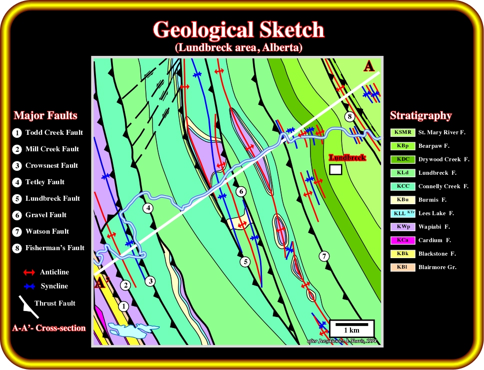
Plate 31 - This geological map shows that the sediments were shortened by folding and faulting induced by a compressional tectonic regime with s1 horizontal striking N 50-60?. Thrust faults and associated cylindrical folds are easily recognized as well as zig-zag echelon faults. Note the location of the geological cross-section A’-A illustrated on the next plate.
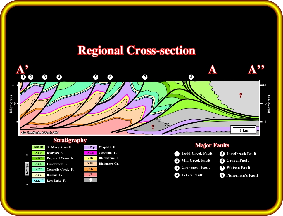
Plate 32 - The limit between the shortened and thickened section of the Foothills and the Plains is marked by a triangular zone which can be taken as a front fold belt. In the western section of the Alberta syncline several discontinuities or detachment surfaces are considered. They are the upper detachment boundary of the deformed front fold detachment. Most of the east dips on these detachments are the result of the uplift from below as the deformed Mesozoic were moved relatively eastward (underthrust) beneath the detachment.
![]()