Let's start by the North Congo onshore basin, i.e., the onshore located northward of the Congo river and particularly in the Cabinda onshore.
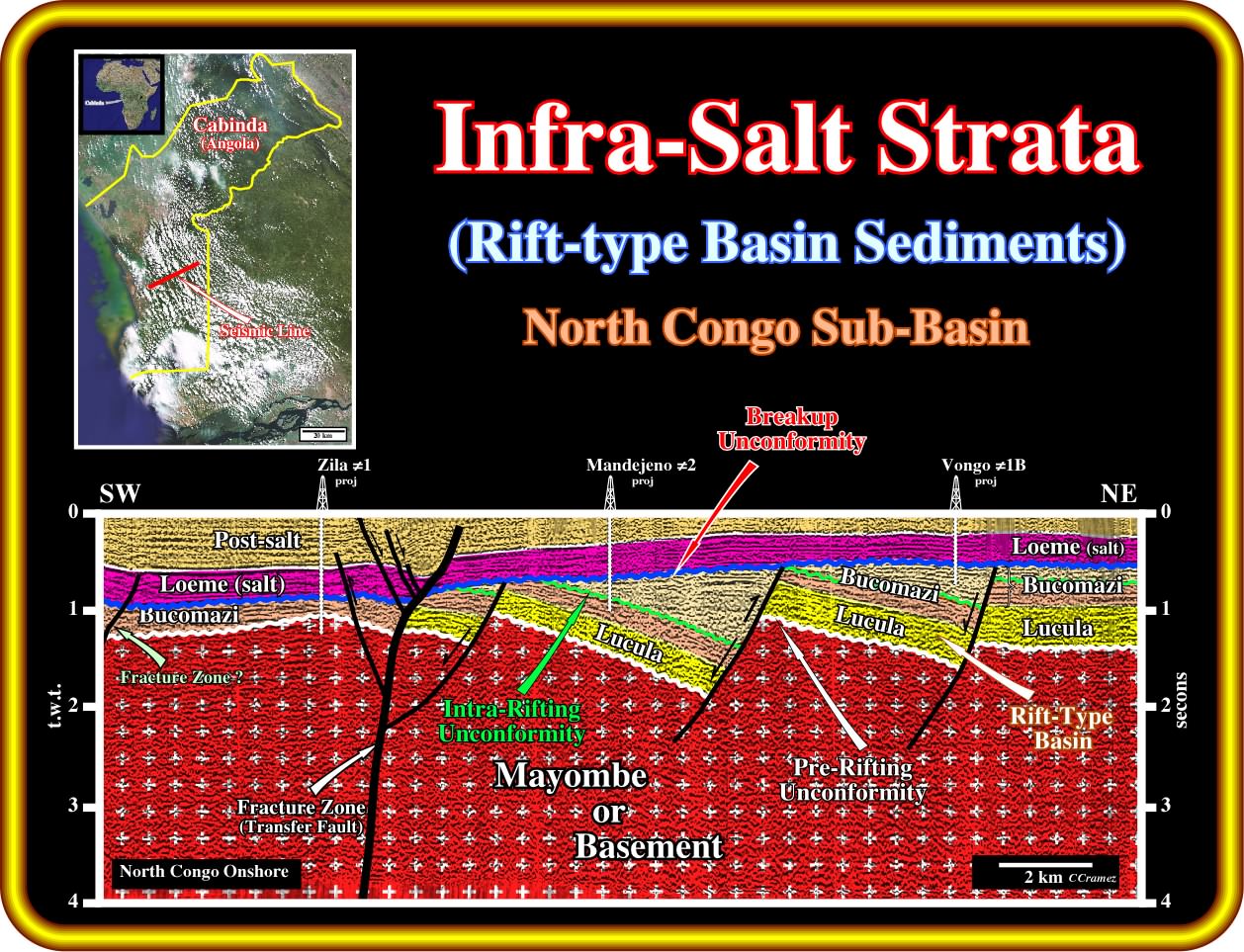
On this geological tentative interpretation of a onshore seismic line of North Congo basin (Cabinda), the presence of infra-salt strata is obvious. Seismically speaking, such strata belongs to pre-breakup rift-type basins and not margin sediments. However, the wells drilled in the area recognized margin infra-salt sediments (Chela sandstones). In spite of the fact that the thickness of the margin infra-salt sediments is often under seismic resolution, they can be considered not only as a excellent migration path, but a potential reservoir-rock as well. Indeed, since a trap is identified in the Chela sandstones (structural, morphological by juxtaposition or hydrodynamic), generally, it contains hydrocarbons.
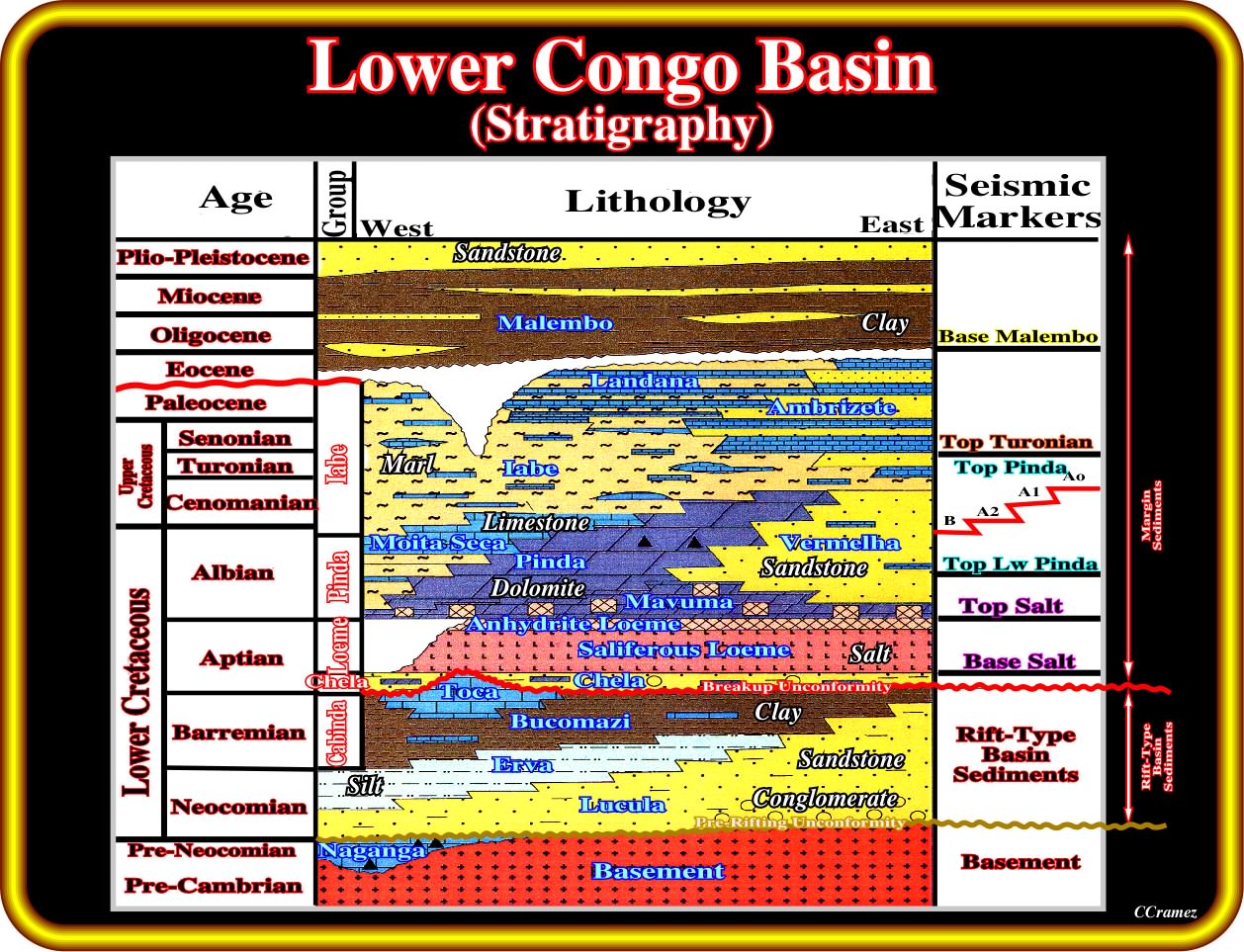
As illustrated in this plate, the stratigraphic column of the South Congo Basin (onshore and conventional offshore) is more or less the same than that of the North Congo basin. A geological formation with a carbonate facies is, often, recognized below the pre-rifting unconformity, which is the lower limit of the pre-breakup rift-type sediments. From the bottom to top, three main geological formation can be recognized: (i) Lucula ; (ii) Erva ; (iii) Bucomazi. Locally, in association with the structural high points, lacustrine reefs or and bioherms (circumscribed mass of rock exclusively or mainly constructed by sedimentary organisms such as corals, algae etc.), can be developed. A relatively thin, often under seismic resolution, margin infra-salt sandprone formation (Chela) overlies the breakup unconformity. It is important to notice, that in onshore, the margin infra-salt sediments are limited to the thin Chela formation, which it is not the case particularly in deep offshore, where a huge depocenter (geometrically similar to a cratonic or sag basin) is recognized on the seismic lines.
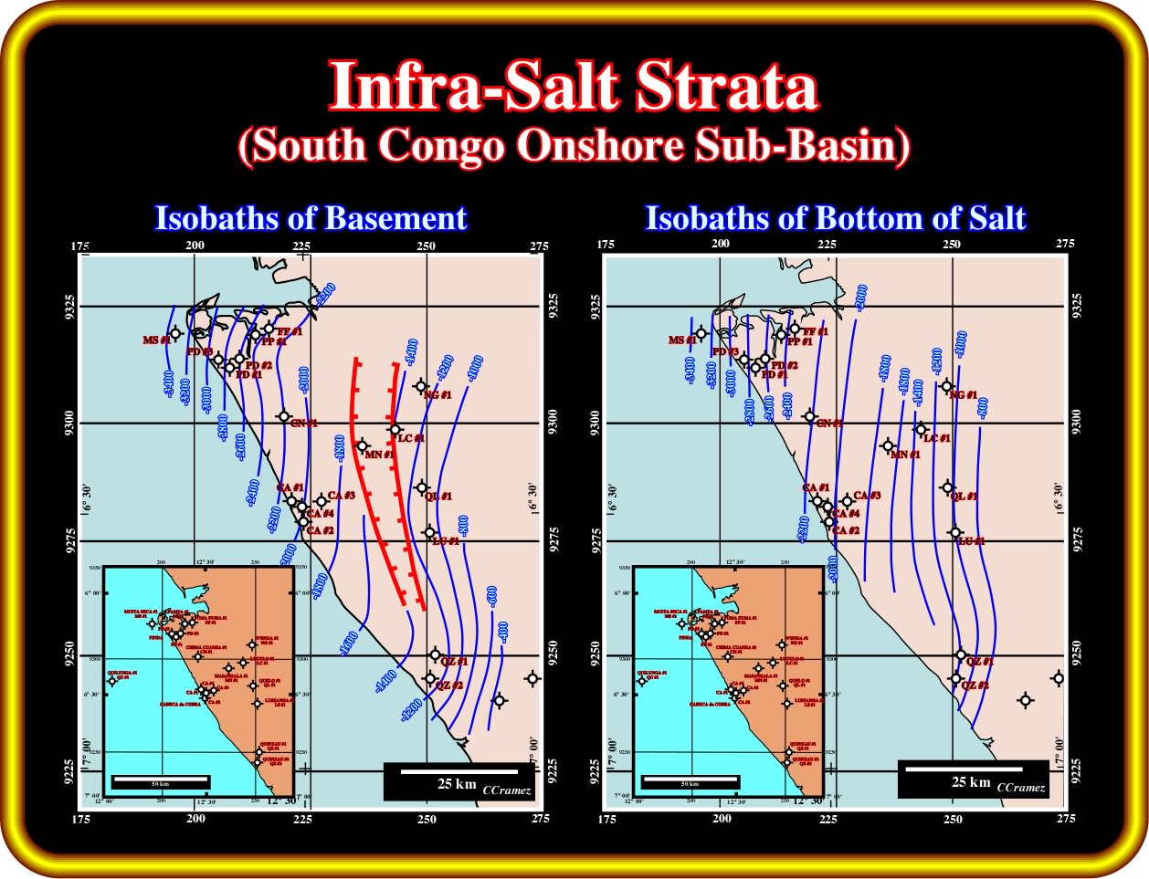
These two maps (isobaths of the basement and isobaths of bottom of the salt) corroborate the presence of a rift-type basin sediments in the onshore South Congo basin, as was suggested by gravimetry and old seismic lines shot, in the 60's, by Petrangol (subsidiary of Fina in Angola).
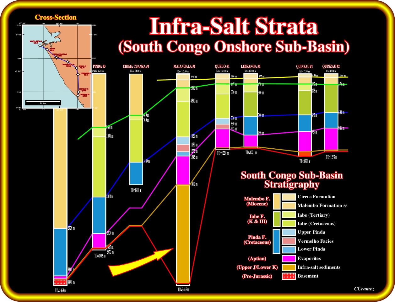
This cross-section passing through the majority of the wildcat drilled in the South Congo onshore, illustrated quite well by the Maiangala rift-type basin, in which more than 1600 meters were recognized. Margin infra-salt sediments are present but their thickness is metric, that is to say, under seismic resolution. On this area, it is interesting to notice the continuity of the salt layer, which was recognized in all wildcat with appropriated depth. Do not forget that thin sandstone layers can be interbedded with the salt (some of them contain hydrocarbons), as it is the case in Cabinda onshore. However, the petrophysical characteristics of such a sandstone layers are not very good since the halite plugs a lot of porous.
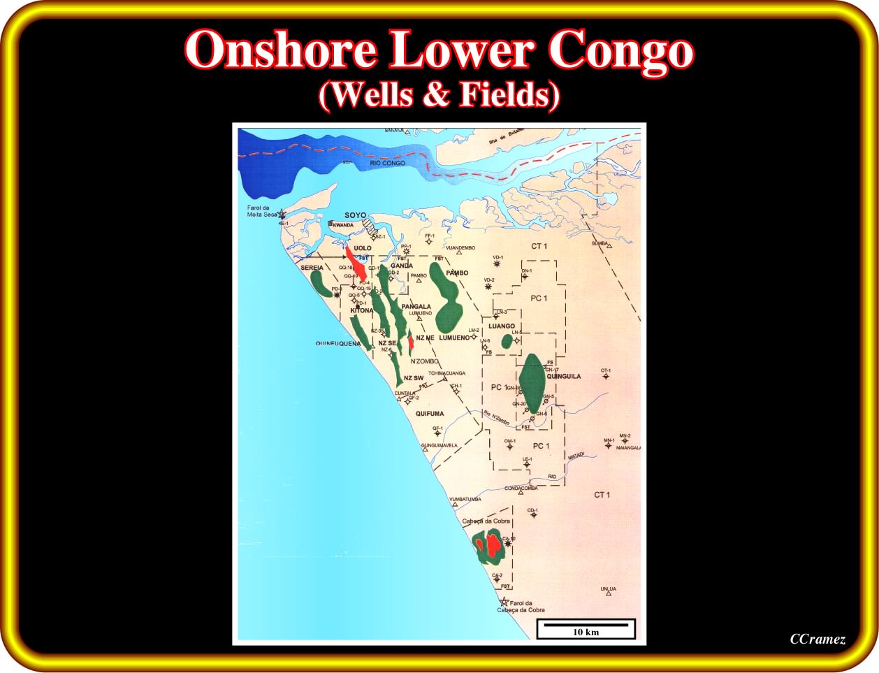
As illustrated in this plate, several small oil and gas accumulations were found, so far, in South Congo onshore. The majority of geoscientist having worked in this area assume that the main petroleum system (genetical relationship between a sour-rock and a petroleum accumulation, that is to say a natural system that encompasses a pod of active source rock and all related oil and gas and which includes all the geologic elements and processes that are essential if a hydrocarbon accumulation is to exist) is Bucomazi / Pinda (Bucomazi, is the source-rock and Pinda the reservoir-rock). However, as illustrated previously, seems that just the Maiangala rift-type basin is large enough to generate hydrocarbons. Nevertheless, one can exclude that the accumulations near the shoreline, as Cabeça da Cobra, for instance, are associated with another generating petroleum subsystem located offshore.
On this plate are illustrated the concessions, fields, oil in place, recovery reserves, remaining reserves and cumulative production, as seen in year 2000 by Petrofina geoscientists. Taking into account the geographic location and new exploration-production technologies, I guess that small and efficient oil companies still can win money in this area. But that is another problem.
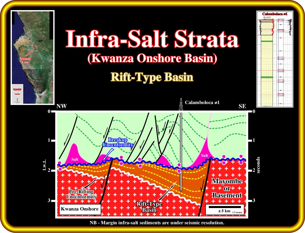
In this geological tentative interpretation of an old onshore Kwanza seismic line passing through the Calamboloca well, infra-salt sediments are obvious. However, the majority of them correspond to rift-type sediments. The thickness of the margin infra-salt sediments, here known of Cuvo formation, recognized by all wells drilled in the area, is under the seismic resolution. The geometry of the rift-type basin is that of a half-graben looking eastward, that is to say, that the bordering faults look westward and the infilling sediments dip westward with an internal configuration divergent. It is interesting to notice that such an internal configuration (divergent toward the bordering fault), is incompatible with a lac formation, since as soon as space available for the sediments is formed, it immediately filled up by sediments (mainly sandstones). In other words, the presence of potential source-rocks (organic rich sediments) is unlikely. On the contrary, when the internal configuration of a rift-type basin is, more or less, parallel the rate of lengthening is not compensated by the terrigeneous infilling (the space available for the sediments is not completely filled), what implies the formation of a lake in which life is developed. Consequently, the late infilling of the lake can preserve the organic matter accumulated in the bottom of the lake and form potential source-rocks. Summing up, a divergent internal configuration suggests potential reservoir-rocks as it is the case in Calamboloca ≠1, while a parallel configuration suggests the presence of lacustrine source-rocks.

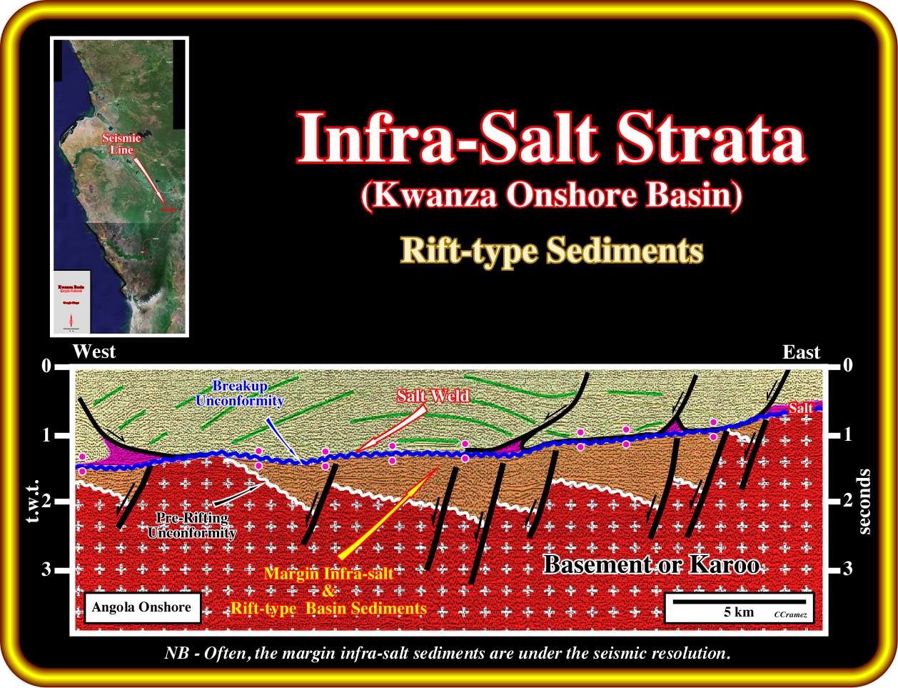
In these schematic geological interpretation of two old onshore Kwanza seismic line shot by Total CAP (subsidiary of Total in Angola) in the 60's. The presence of more or less parallel seismic reflectors strongly suggests the presence of infra-salt strata. However, taking into account the geometry and internal configuration of such infra-salt intervals, it is unlikely that they correspond to rift-type basin, which, generally, dip landward. More likely they correspond to margin infra-salt sediments, deposited either immediately the breakup unconformity, that is to say, above the continental crust or/and rift-type basins or above the post-breakup subaerial volcanic crust (generally lava flows), which thickness can be quite important.
On this geological tentative interpretation of an old onshore Kwanza (Goze area) seismic line, rift-type basins with potential source-rocks (the internal configuration is locally, more or less, parallel) are obvious. They are limited between the pre-rifting and breakup unconformities. The margin infra-salt sediments (sandstone of the Cuvo formation) are under seismic resolution The turtle-back structure, in the supra-salt sediments, and the primary salt welds are easily recognized.
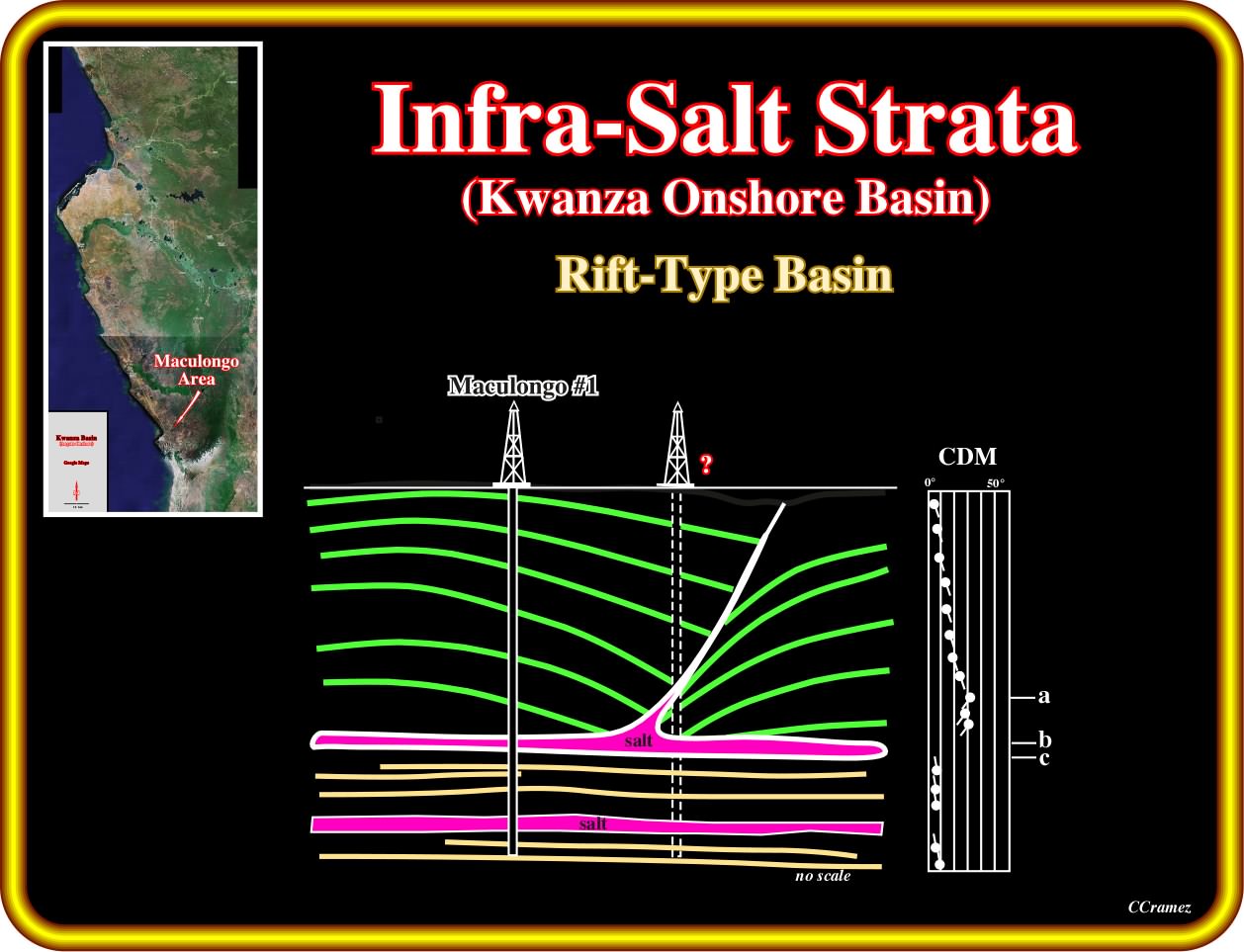
The presence of a significant rift-type basin was corroborated by Maculongo ≠1, in the 60's by Petrangol, in the southern part of the Kwanza onshore. This well has two particularities : (i) The Aptian salt was recognized as predicted ; (ii) Another level of salt was found within the rift-type basin. As illustrated in this plate, the first reaction of the Total Cap's geoscientists, which did not knew the Petrangol data, was to assume that the well location was not correct and that the well before reach the salt cross a fault weld filled by salt. In fact, such a conjecture seems to be wrong, that is to say, the location of the well is right and the salt layer within the rift-type basin seems to be there. However, the composition of the salt found in the rift-type basin must be quite different of the that of the Aptian salt, since the lower layer predates the breakup of the lithosphere, while the Aptian salt postdates the breakup unconformity. Subsequently, the pre-breakup salt cannot be hydrothermally enrich by the volcanism, which was emplaced after the breakup unconformity.
Exercise 1:
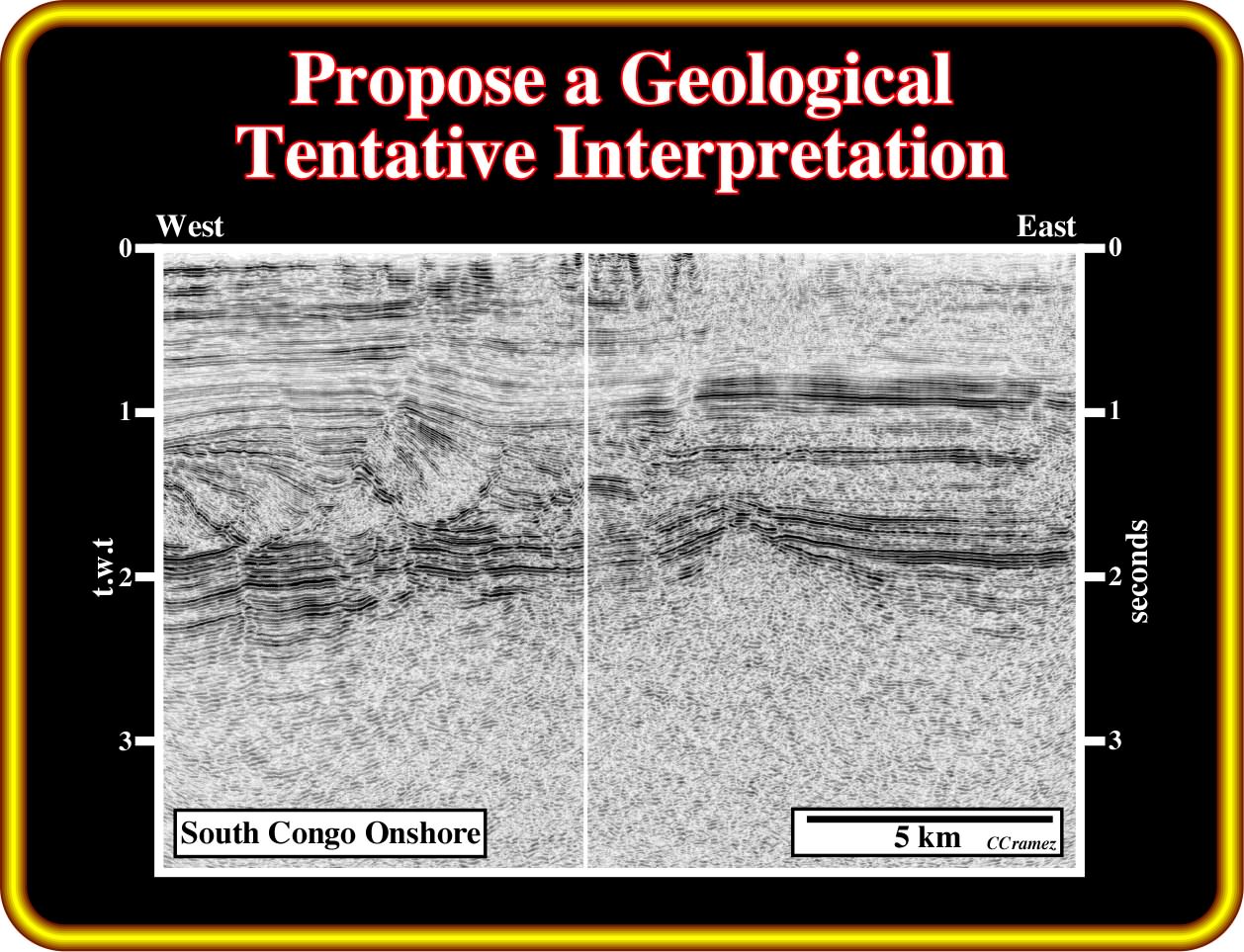
On this seismic line, you must start to propose a geological tentative interpretation not only of the supra-salt strata, that is to say of the overburden, but particularly of the infra-salt strata as well. That note that according to the results of the wells drilled in this area, the thickness of the margin infra-salt sediments is under seismic resolution. In other words, seismically speaking, the of the infra-salt reflections correspond, mainly, to interfaces within the rift-type basin sediments. However, a toplap geometrical relationship is easily recognized at the bottom of the rift-type basin sediments (in western half part of the seismic line). Consequently, propose the more likely lithology of the seismic interval underlaying the rift-type basin sediments.
Exercise 2:
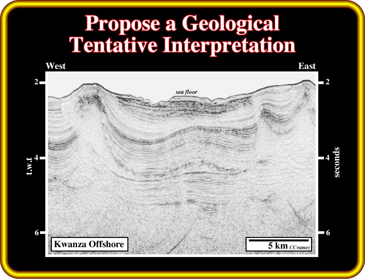
On this seismic line, you must, first of all, pick the bottom of the salt or and is associated primary salt welds. Then, you must propose the more likely stratigraphy of the infra-salt strata, omitting the margin infra-salt strata, which thickness is probably under seismic resolution. In other words, the large majority of the infra-salt reflectors are induced by interface between rift-type basin sediments. Do you recognize some reflectors associated with the infrastructure (volcanism) or the basement (continental crust) ?
Exercise 3:
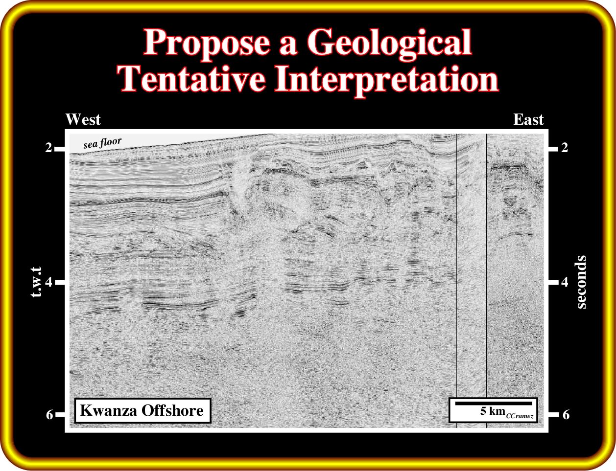
On this seismic line from the conventional offshore of the south Kwanza basin, can you recognize below the margin infra-salt sediments some indications of a lengthened continental crust ? Propose a geological tentative interpretation, given a particular attention to the stratigraphy and the more likely facies (lithology) of the infra-salt strata.
to continue press
next
![]()