
11) What is the more likely geological context of Kwanza basin?
Several geological models have been proposed to explain the infrastructure of the Kwanza basin. Some of them are too dogmatic and they do not resist to bold seismic and wells' results tests, that is to say, they are easily refuted either by the lithology recognized in the exploration wells and geological tentative interpretation of the seismic lines, but by regional geological context as well.
The geological model assuming that :
(i) The breakup unconformity, i.e., the breakup of the lithosphere separates the lengthened continental crust, and associated rift-type basins, from the margin infra-salt sediments, what few geoscientists resist to admit ;
(ii) The breakup of the lithosphere happens in an highly volcanic intruded and lengthened continental crust, when the mantelic material exceeds the continental material ;
(iii) The continental crust cannot be lengthened (normal faulting) when the extension rate reaches more or less 4, that is to say, when the thickness of the lithosphere is lower than 15-10 kilometres ;
(iv) A subaerial expansion (emplacement of lava flows) took place immediately after the breakup of the lithosphere ;
(v) The post-breakup lava flows dip and thick outward toward the location subaerial spreading centres ;
(vi) The oceanic expansion took place after the sinking through sea water of the subaerial expansion centres due to the loading of the successive lava flows ;
(vii) Above the allochthonous salt layer, margin sediments are deformed by salt tectonics and halokinesis ;
(viii) Below the margin allochthonous salt layers, strata is generally undeformed, creating salt induced tectonic disharmony at the bottom of the salt;
(vii) A major unconformity (breakup unconformity) separates the margin infra-salt sediments from the rift-type basin sediments ;
(viii) Margin infra-salt sediments can be quite thick, particularly when overlying post-breakup subaerial volcanism ; they can form a decanter or a cratonic like sub-basins, in which organic rich interval (potential source-rocks) can develop, as well as carbonate reservoir-rocks ;
(ix) Margin infra-salt sediments, general, dip continentward in the central and eastern area of the decanter and seaward in central and western area of the decanter ;
(x) The post break subaerial crust (generally lava flows with associated sedimentary layer rich in volcanic material) dip and thick seaward (in direction of the subaerial spreading centres) ; they can be lengthened, that is to say, affected by normal faulting with development of half grabens and grabens, due to the seaward sinking instigated by the loading of the lava flows.
(xi) The post breakup subaerial crust has not generating petroleum potential ;
(xii) The geometry of the rift-type basins, when present within the lengthened continental crust, corresponds to that of an half-graben with the bordering fault (maximum of differential subsidence) looking seaward ;
(xiii) Sedimentary intervals within rift-type basin can be rich in organic matter ( type I, i.e., lacustrine) and form a important generating petroleum sub-system ; on the other hand, sandprone and carbonate reservoir-rock intervals are likely ;
(xiv) The basement can be formed by Precambrian granite gneiss (with garnets), Paleozoic sediment (folded belt) and locally volcanic rocks predating the breakup of the Gondwana lithosphere ;
(xv) Fractures zones striking roughly SW-NE, probably of Gondwana age or even older, seem to control the lengthening of the continental crust playing as extensional strike-slip faults and the geometry of the breakup; on the other hand, some of them are reactivated during Cenozoic clearly displacing the bottom of the salt (or the salt induced tectonic disharmony) and develop ping, locally, compressional, that is to say, shortened structures ;the more invoked reasons to explain the reactivation of these fracture zones are readjustments of the lithospheric plates and ridge-pushing.
(xvi) The hot spot trails suggests that the strike of the main fracture zones seems to have controlled the break-up of the Gondwana and later the sea floor spreading. In fact, all along the western African margin, different geological provinces are individualized by the major fracture zones. Each geological province has its own petroleum systems and a particular seaward tilting. On the seismic lines, the fracture zones can be indirectly recognized by abrupt depth changes either of the substratum (or basement) or the base of the salt layer in evaporite basins as in Kwanza and Congo basins. Similarly, in the salt basins, local compressional salt structures (tectonic inversions) are often induced by reactivation of deep buried fracture zones. Actually, in certain areas of the offshore Angola, post-salt oil fields seem to trend along the fracture zones.
This geological model is, by far, the one more difficult to falsify, that is to say, is the model that better resist to testing. Consequently, and in expectation that someone propose a another model more difficult to refute, we will adopt it to explain the major geological events and the main potential petroleum systems.
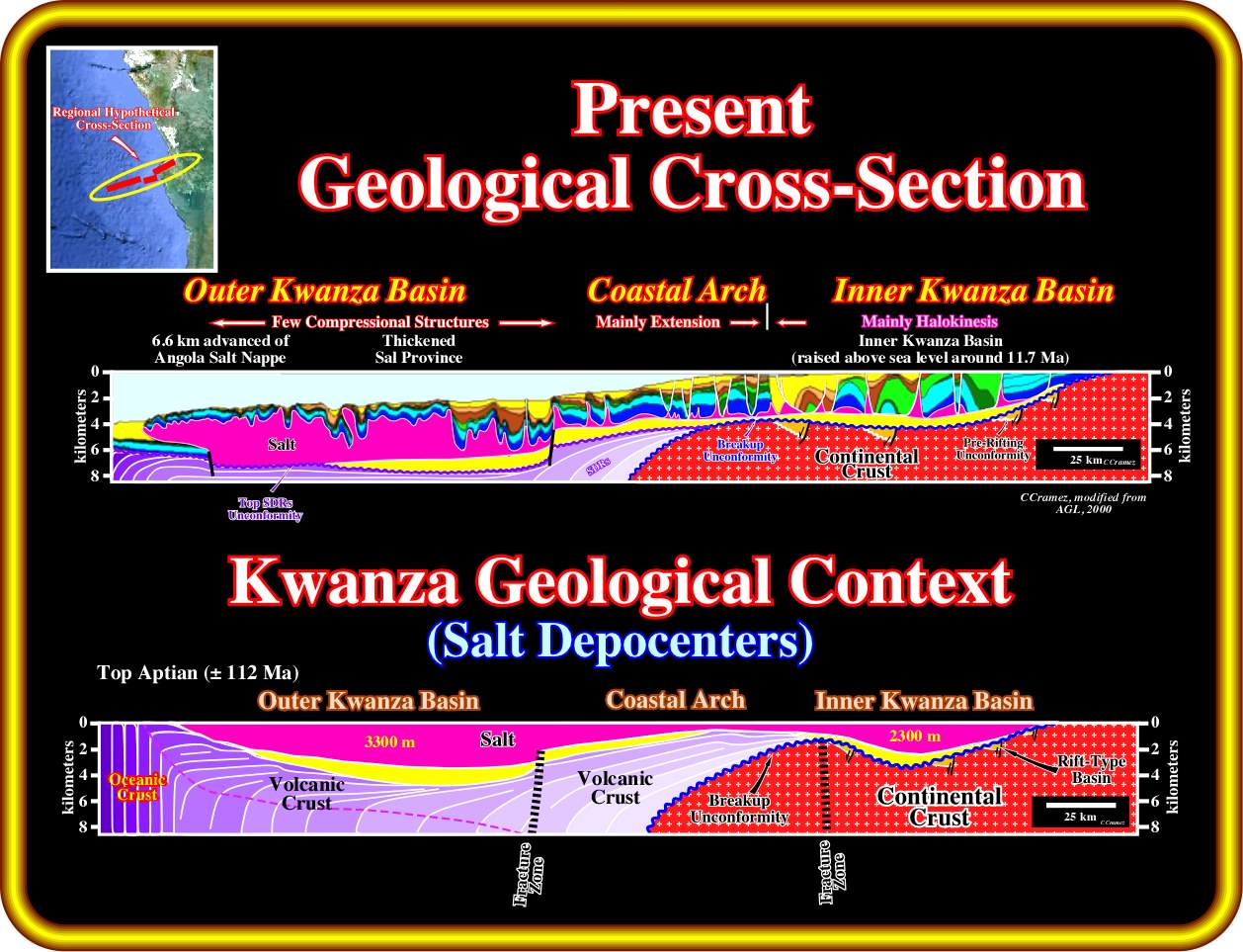
The upper geological cross-section corresponds to a geological tentative interpretation of a composite seismic line of the Kwanza basin (offshore and onshore), which location is shown is the map illustrated on the upper left corner of this plate. As indicated, the Kwanza basin can be subdivided into a two sub-basins separated by a relatively structural high called by some geoscientists as Coastal Arch. The proximal sub-basin is known as Inner Kwanza basin and the distal as Outer Kwanza basin. The Inner Kwanza basin corresponds roughly to the Kwanza onshore, while the Outer Kwanza basins corresponds mainly to the deep offshore. The Coastal arch corresponds, more or less, to the conventional and upper deep offshore, in which, at the base of salt, one can recognize significant steps or ramps of the infra-salt strata that the salt fossilized by onlapping. The substratum of the Outer Kwanza basin seems to be mainly formed by post-breakup volcanism, probably by lava flows thinning and often dipping seaward ; the salt was shortened and thickened by thrusting faults inducing a lot of allochthonous salt. The substratum of the Inner Kwanza basin seems to be mainly composed by a lengthened continental crust, in which rift-type basin developed, since the only way to the length rocks is by normal faulting. These rift type basin are apparently displaced by the fracture zones, that is to say, they seems displaced by strike slip faults (fracture zones), but in fact they are not. Different rift-type basins are developed each side of the fracture zone as it happens every time that a pre-faulted basement is extended or lengthened. The geological reconstitutions of this geological cross section indicate that at the end of the salt deposition (top Aptian), two salt decanters were separated by the Coastal arch, which was fossilized by a relative thin salt interval. The maximum thickness of the internal salt decanter was more or less 2000-2500 meters, while the maximum of the external decanter exceeded 3000 meters.
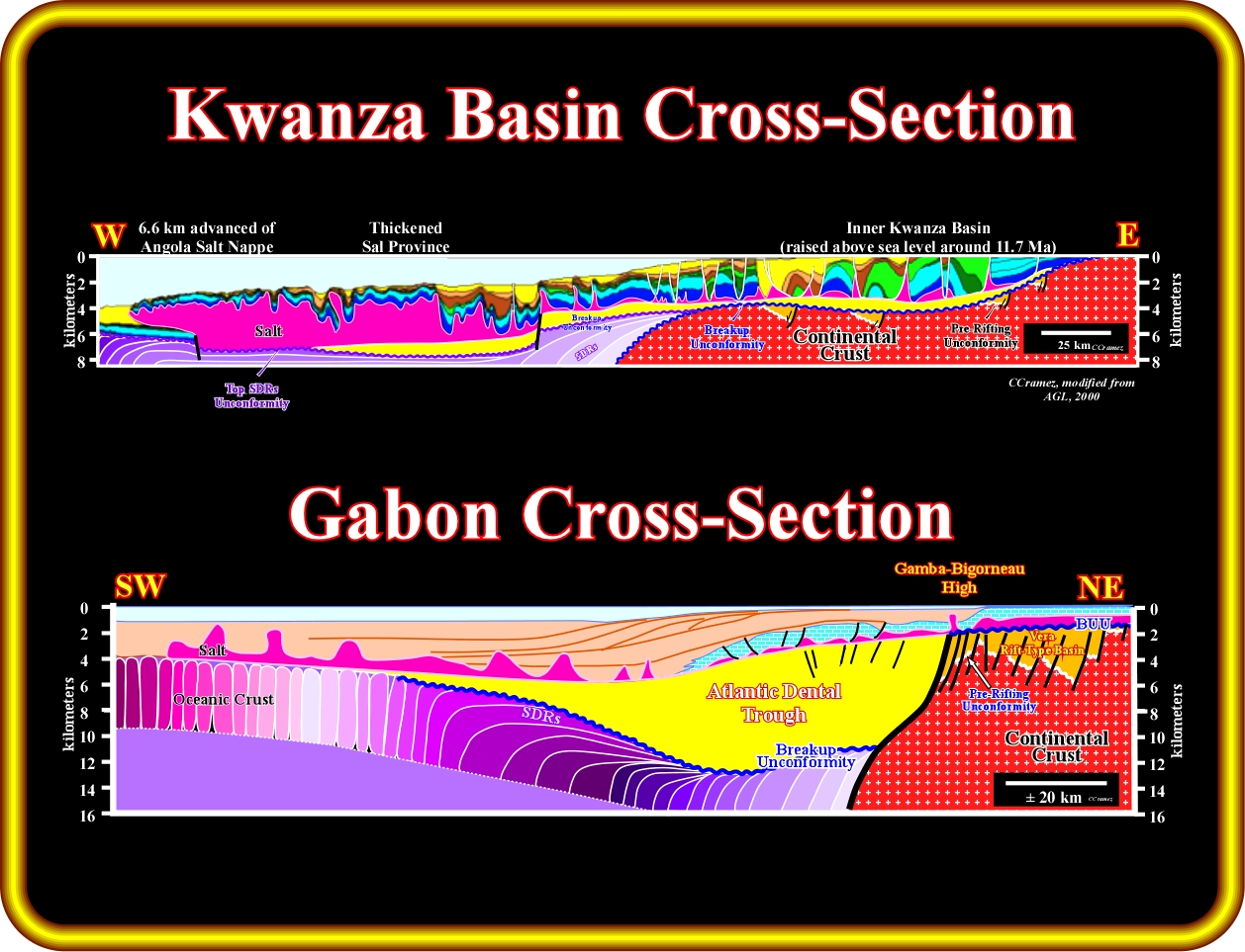
As illustrated in this plate, using the geological model adopted to explain the Kwanza basin, the Atlantic Dental through correlates with the Margin infra-salt deponent of the Kwanza basin and the Vera rift-type basin with the pre-breakup rift-type basins. However, as one can see on this plate, the thickness of the Dental through is much bigger than the maximum thickness of the Kwanza infra-salt deponents. In spite of the fact that does not means causation, it is important to point out that the old Elf and Petroconsultant geoscientist said,since longtime, contrariwise to certain bosses of temporary company TotalFinaEft, that generating petroleum sub-system found in Santos offshore (Brazil) could be considered as an equivalent of the generating petroleum sub-system found (longtime ago) in the Dental trough, even if the Brazilian and Angola margins have always been twined margins and not a single margin split in two as certain geoscientists dogmatically pretend.
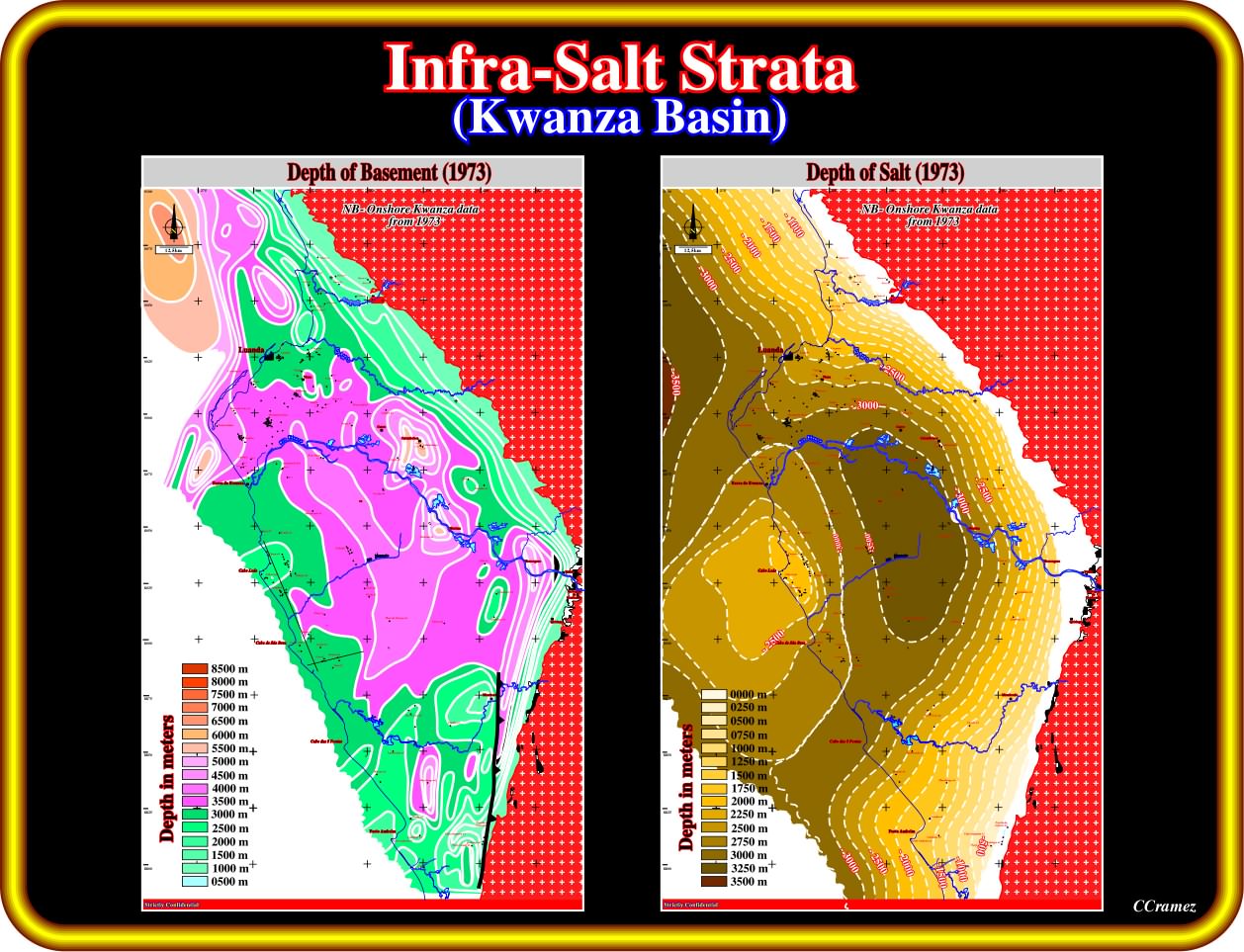
Taking a quick look at these two maps, anyone can prognosticate, at least, the presence of an infra-salt strata in the Kwanza inner basin, without differentiate the margin infra-salt sediments from the rift-type basin sediments. However, making a more accurate observation at the map of the depth of basement (do not forget that these maps were made with the old data, i.e., without any information coming from the interpretation of the the new onshore seismic lines shot by Sonangol), it is possible to suggest that the pre-breakup rift-type basins are located in eastern part of the Inner Kwanza basin and that the margin infra-salt sediments are responsible by the central deponent. On the other hand, the map of the bottom of the salt clearly underlines the Central Arch, which seems obvious between Luanda and Porto Amboim,with its shallow area around Cabo Ledo. Northward of Luanda and southward Porto Amboim, the Coastal seems to be not too significative. In addition, as illustrated previous the Inner Kwanza Basin is segmented into five provinces by northeast-striking fracture zones, interpreted to have originally formed before the Neocomian rifting. the evidence for these zones is : (i) Jogs in the coastline ; (ii) Changes in structural elevation of exposed strata ; (iii) Changes in rift asymmetry ; (iv) Edges of basement-block uplifts ; (v) Terminations of depotroughs and fold belts. Stratigraphic data suggest that the basement-block uplifts and their bounding transfers were reactivated repeated.
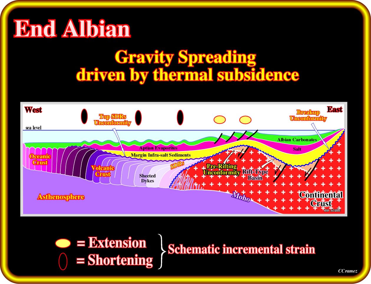
Taking into account the adopted geological model, the wells' results, the geological reconstructions and the geological tentative interpretation of the available seismic lines one can said that at the end Albian, that is to say, after the deposition of the carbonate interval overlying the Aptian salt, a gravity spreading driven by the thermal subsidence created an extension (lengthening) of the salt and overburden the crustal arch and a compression (shortening) in the outer Kwanza basin, while the inner Kwanza basin the halokinesis was preponderant. Notice that is this plate the mantelic intrusion in the western border of the continental were drawn just to illustrated that the breakup of the lithosphere was not due to an extremely thinning of the lithosphere, but rather to an widespreading intrusion of mantelic material in the lengthened continental crust. On the other hand, it is quit evident that, in this sketch, the thickness of the margin infra-salt sediments is highly exaggerated. However the three salt domains, that is to say, the Inner Kwanza basin, the Coastal Arch and the Outer Kwanza basins as easily recognized.
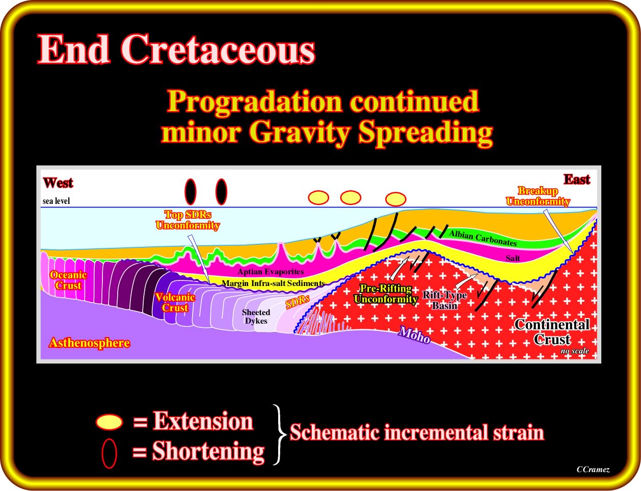
At end Cretaceous, the area of the Coastal arch was reactivated, that is to say, it was slightly uplifted. In the inner Kwanza basin, sedimentation continued with a salt layer more or less stable (conventional halokinesis). Seaward of the reactivated coastal arch, extension was preponderant, while in the deep outer Kwanza basin compression was paramount was an answer to the updip extension of salt and overburden. A folded belt developed on the strata overlying the salt induced tectonic disharmony. The infra-salt strata, i.e., infra-salt margin sediments, subaerial volcanic crust, rift-type basins and basements rocks, were buried during the deposition of the Upper Cretaceous sediments and later upper slightly uplifted near the coastal arch province. However, the organic rich layers of the margin infra-salt deponents did not reach maturation, which is not certain for certain organic rich layers of the rift-type basins sediments.
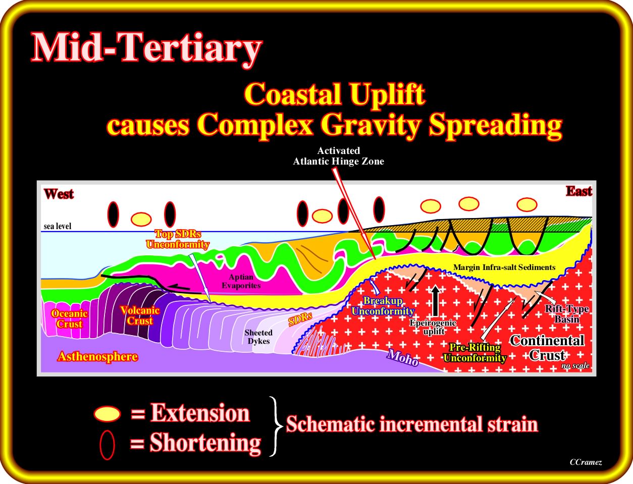
In the Mid-Tertiary, not only the Atlantic Hinge zone, which can be taken as the westward limit of the Coastal Arch province, was reactivated, but all the inner Kwanza basin was strongly uplifted as well. Consequently, an important extensional tectonic regime was developed in the Coastal arch and inner Kwanza basin in association with the Tertiary uplift, while local compressional tectonic regime persist near the Atlantic Hinge zone and in the deeper part of the outer Kwanza basins. As a consequence of the salt-induced compressional tectonic regime a folded belt and significant salt-induced nappe formed the Angola Escarpment, which in turn created a local extension tectonic regime. The uplift created a significant relative sea level fall, which caused an important erosional phase, probably responsible of the Oligocene unconformity. Admittedly, the consequences of the Mid-Tertiary uplift in the infra-salt strata are quite important for the the development of petroleum systems. In fact, presently, the infra-salt organic rich intervals are at depths that without the uplift are incompatible with oil generation. However, as B. Kubler show in the 60's the reflectance of the vitrinite clearly indicated an original burying allow the maturation of the organic matter. Another important consequence of the Mid-Tertiary uplift, which occurred mainly in the Coastal Arch and Inner Kwanza basin, is the possibility of formation of a descendant hydrodynamism current (opposite to the updip migration of the hydrocarbons), which, when the reservoirs-rock is a, more or less, continuous migration path, can favour or destroy the trapping, tilt the water plan contact, etc. Obviously, when a descendent hydrodynamism is present, as it the case in certain Cuvo or Chela fields, the tilting of the water plane contact is, according the Hubbert's law (tgf= dh /dx X dw/(dw-dh), in which f is the angle of the water-oil contact with the horizontal ; dh / dx is the dip hydraulic nappe ; dw is the density of the water and dh the density of the hydrocarbons), even stronger than the hydrodynamic gradient is important and that the densities of oil and water are closer of 1. When the hydrodynamic flow is very important the hydrocarbon accumulation can be completely wiped out of the trap. Under such conditions, it happens that in these traps the hydrocarbon column exceeds the theoretical closure, determined from the structural maps of the reservoir-rock.
Exercise 1:
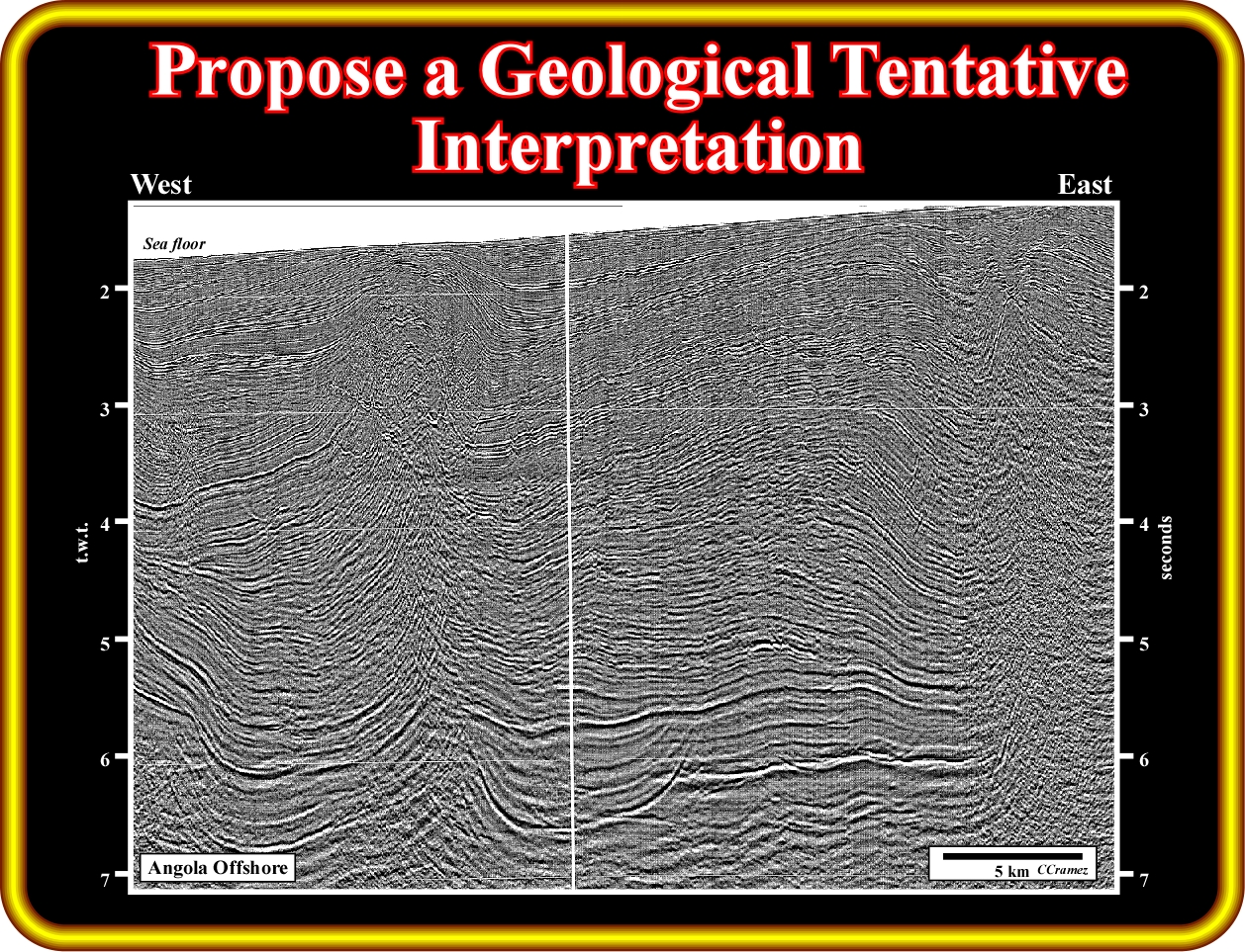
On this seismic line of the deep water Angola offshore (South Congo Basin), propose an exhaustive geological tentative interpretation. Start to pick the salt induced tectonic disharmony with the associated salt welds. Then pic the limits of the allochthonous salt and associated secondary salt welds. Explain the structures of the supra-salt strata. Try to interpret the infra-salt strata and propose the more likely facies.
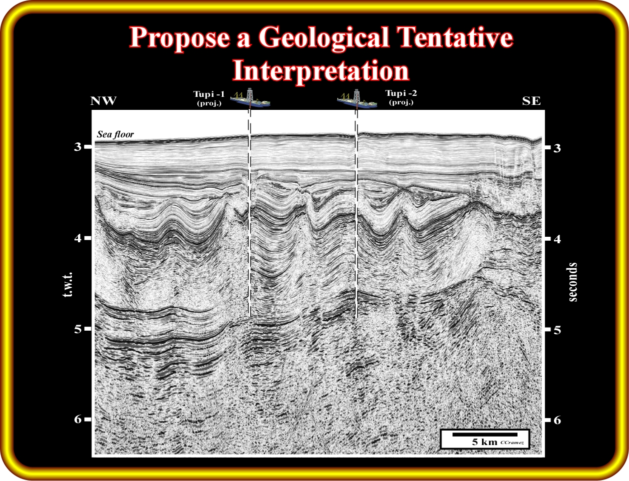
Exercise 2:
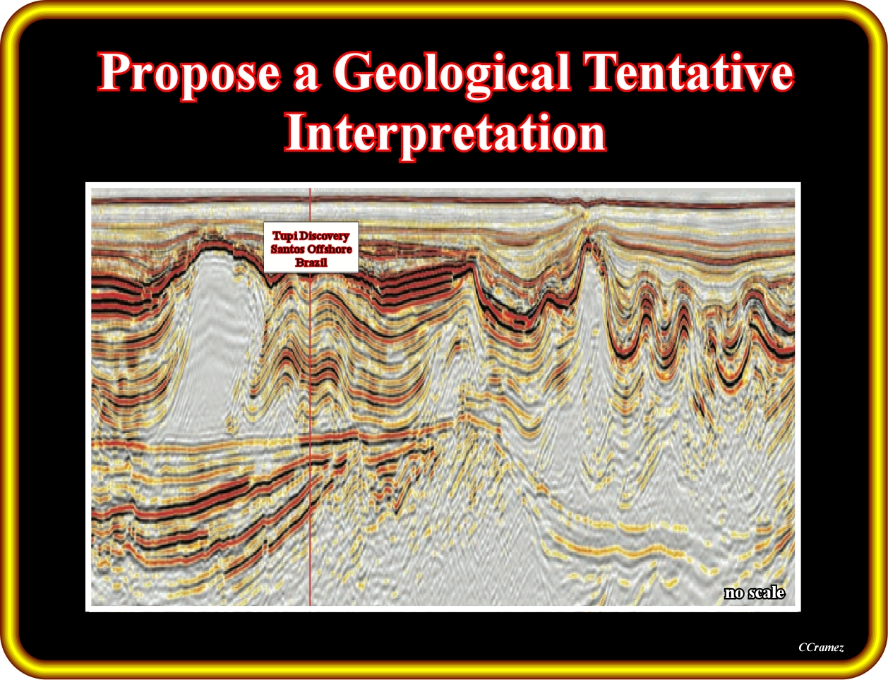
This seismic line from the Brazil offshore is probably similar to the new seismic lines shot by Sonangol in the Kwanza onshore. Consequently try to propose an exhaustive geological interpretation of the infra-salt strata, separating the margin infra-salt sediments, which post-date the breakup unconformity from the rift-type sediments than pre-date the breakup of the Gondwana lithosphere. How do you explain the geometry of the salt induced tectonic disharmony ?
Exercise 3:
This seismic line is located nearby the line of the exercise 2, where a major hydrocarbon was found several here ago in the infra-salt strata of the Santos basin. Propose a geological tentative interpretation, particularly of the infra-salt strata, put in evidence the breakup unconformity and the more likely reservoir-rocks intervals.
to continue press
next
![]()