of
Kwanza and Congo Infra-salt Strata
Caveat:
This workshop, sponsored by Puspetrol, was prepared for Sonangol's geoscientists. The data utilised corresponds to an eclectic assemblage of geological models, cross-sections and geological tentative interpretations of seismic lines, which illustrate the main geological principles and hydrocarbon problems discussed during meetings on the petroleum potential of the Kwanza and Congo basin (Sonangol, Total SA, Pluspetrol, Marathon Oil Company and Petrobrás), in which I participated. The text is reduced to a minimum. In the figures, as well as, in the geological tentative interpretations of the seismic lines, for confidential reasons, often, the locations and orientations of the lines are not indicated. In spite of the fact that, the original seismic data belongs, mainly, to Sonangol and Total SA, the majority of plates and, particularly, the geological tentative interpretations of the seismic lines are personal. The author is the only responsible for the conjectures and hypothesis advanced in this notes, as wells as, dall along of the workshop. Any of the of plates presented here cannot be used or reproduced, publicly, in any manner whatsoever without written permission. So tthat, Ppease contact carloscramez@gmail.com ; severino.cardoso@sonangol.co.ao ; gillesh.bitoun@total.com or mrosso@pluspetrol.net).
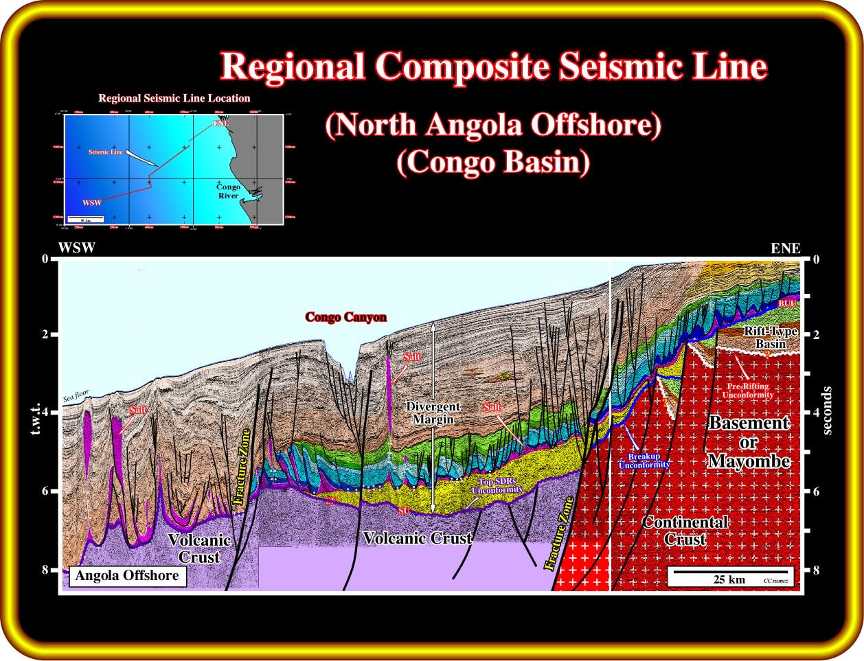
This geological tentative interpretation of a composite seismic line of the Northern Angola Offshore (Congo Basin) illustrates the geology and potential petroleum systems of the South Atlantic offshores, i.e., of the evaporitic Atantic-type margins. Above the Gondwana basement, which can be formed by Precambrian granite-gneiss or Paleozoic folded belts (Karoo formation included), from bottom to top one can recognize : (i) Several Lower Cretaceous rift-type basins, developed during the lengthening of the Gondwana lithosphere, that is to say, predating the breakup unconformity (BUU) and postdating the pre-rifting unconformity (PRU) and (ii) An Altantic-type divergent margin deposited after the breakup of the Gondwana lithosphere in association with the oceanization between the two major lithospheric plates (Africa and South America) individualized by the breakup of Gondwana. Admittedly, at least in this area, the rift-type basins seem to be much more developed, and better known, in the conventional offshore and onshore than in deep water. In fact, so far, in deepwater, any rift-type basin was recognized by drilling, which is not the case in the conventional offshore and onshore. In the central part of this line, above unconformity (SU, i.e. the unconformity at the top of the subaerial volcanism), a thick infra-salt sand-shale interval (in yellow on this tentative), which laterally fossilizes breakup unconformity and the pre-breakup rift-type basins. In the proximal part of the margin (conventional offshore and onshore), the thickness of this infra-salt interval is, often, under seismic resolution. Above, the margin infra-salt interval, a more or less continuous evaporitic interval was deposited. It separates the margin sediments into two realms : (i) The undeformed margin infra-salt sediments and (ii) The deformed supra-salt sediments (salt included). In fact, due to the halokinesis (form of tectonics in which salt flow is powered by buoyancy, i.e., by release of gravity potential energy alone, in absence of significant lateral tectonic forces, σt = 0) and salt tectonics (any tectonic deformation involving salt, or other evaporites, as a mobile layer) created a tectonic disharmony (geological surface individualizing two realms of deformation, often associated with a mobile substratum whether salt or shale) at the bottom of the evaporitic layer (Loeme salt). Above the salt layer, two unequivocal marine sedimentary interval were deposited : (a) The sediments of the transgressive phase of the post-Pangea continental encroachment cycle characterized by a retrogradational geometry, at the bottom, and (b) The sediments of the regressive phase, characterized by a progradational geometry, at the top. Potential source-rocks were be deposited : (1) In rift-type basins (organic rich lacustrine shales), below the breakup unconformity (BUU) ; (2) In the margin infra-salt sediments (lacustrine / marine source-rocks) ; (3) On the top of the transgressive phase (marine source-rocks) and in the deep water sediments of the regressive phase (organic matter type III, dispersive source-source). Reservoir-rocks are present in the rift-type basins (sandstones and carbonates), margin infra-salt sediments (sandstones and carbonates), supra-salt transgressive sediments (mainly carbonates) and in the sediments of the regressive sedimentary phase (mainly turbiditic sandstones). This geological tentative interpretation suggests the occurrence of fracture zones (zones of fragility of the continental crust, which probably favour the breakup of the lithosphere and control the sea floor spreading) and subaerial lava flows postdating the breakup unconformity (on lower central and western part of this tentative). Similarly, it brings forward an important Late Tertiary uplift, which, strongly, affects the proximal area of the margin, and that must be taken into account in all geological interpretations and reconstitutions.
Workshop Overview:
The purpose of this workshop, prepared exclusively for Sonangol geoscientists working in Kwanza and Congo basins, is to acquaint the participants how the South Atlantic was opened and the main hypothesis concerning the petroleum systems developed in these basins. A particular attention will be done to the potential of infra-salt petroleum systems (genetical relationship between an hydrocarbon accumulation and the source-rock, which generated the hydrocarbons) located in onshore and conventional offshore. For that, the best way to deliver this workshop is on the form of questions, answers and exercises.
Questions:
1 - What evidences can be provided for the Late-Tertiary uplift ?
2 - How the South Atlantic Ocean was opened ?
3 - Are there Refutation Tests of COB mapping?
4 - Are SDRs corroborated by the salt composition ?
5 - Are there analogous for the Congo-Kwanza salt basin ?
6 - What can we perceive on Congo Basin regional seismic lines ?
7 - What can be learned from South Congo offshore seismic lines ?
8 - What can be learned from Kwanza offshore seismic lines ?
9 - What is the evidence of infra-salt strata in Congo and Kwanza onshores ?
10 - Are the infra-salt strata rich in organic matter ?
11 -What is the more likely geological context of Kwanza basin ?
to continue press
next