
There are four main evidences of the Late-Tertiary uplift of the SW Africa :
(i) Topography of SW Africa ;
(ii) Erosional truncation on seismic lines ;
(iii) Reactivation of salt steps and fracture zones ;
(iv) Kübler index & vitrinite reflectance.
This Late-Tertiary uplift is extremely important for the petroleum exploration, since it, partially, controls sevaral petroleum parameters. In fact : (i) It put in motion gravity-driven deformations (creation of potential structural ans non-structural traps) ; (ii) It supplies clastic sediments (potential source-rocks), since the associated relative sea level fall was source for offshore Tertiairy sediments outward of the river's mouths (mainly Congo and Kwanza) ; (iii) It induces salt tectonics and halokinesis (formationof potential petroleum traps) by sediment dumping and (iv) It favours maturation of the organic matter of the potential source-rocks, because the accumulation of the eroded sediments increases the burial of the potential source-rocks.
(i) Topography of SW Africa
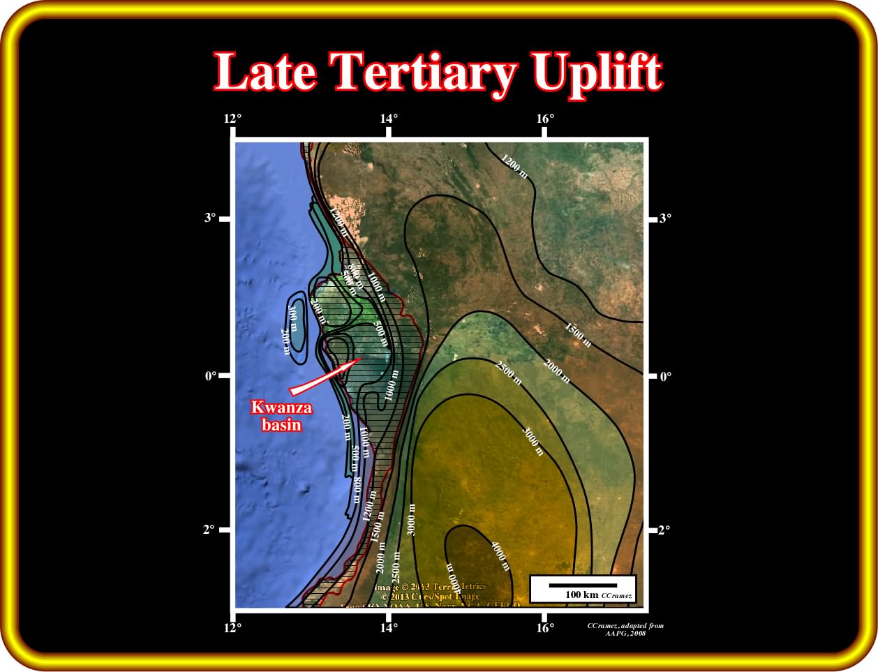
The topography of Africa shows many topographical features, such as deserts, mountains, plateaus and rivers. However, as illustratred in the plate below, the topography of the southern central and southwestern part of Africa is quite significant for petroleum exploration because it suggesst an important recent uplift.
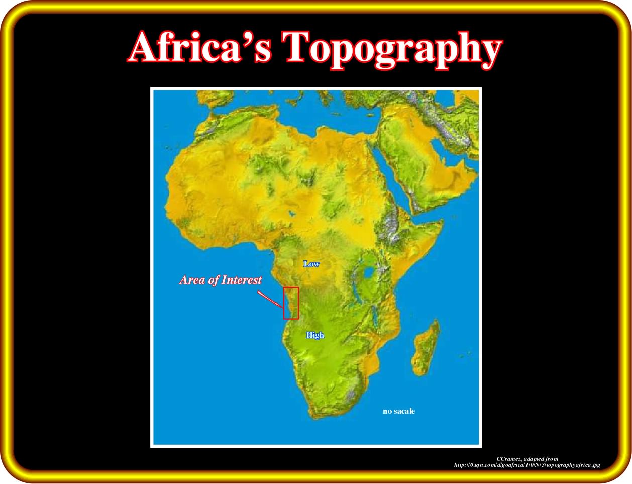
Taking a look to this map is obvious that the area of interest, that is to say, the Congo and Kwanza sedimentary basins are border by a long steep slope or cliff at the edge of a large plateau, which seems to be induced by an Late Tertiary uplift. On the other hand, it is interesting to notice that the northern part of the southern Africa plateau was strongly eroded by a lot of rivers that form the hydrographic Congo basin (Congo watershed, i.e., the entire geographical area drained by a river and its tributaries) as illustrated next.
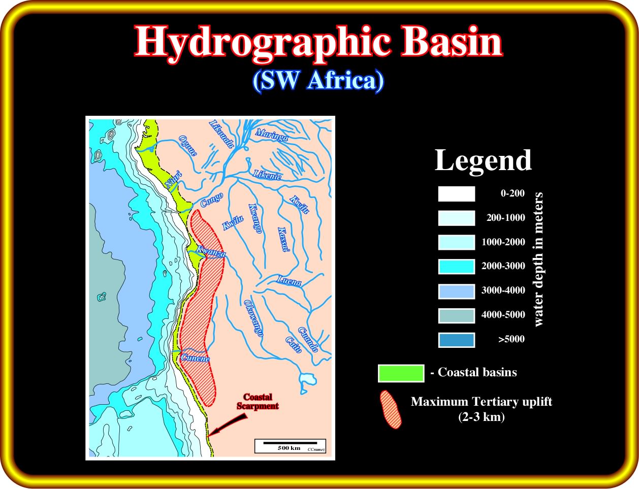
On this schematic hydrographic basin, there are just five significant rivers (more than 500 km length) : (i) Ogone ; (ii) Niari ; (iii) Congo ; (iv) Kwanza and (iv) Cunene, which cross the coastal escarpment of SW Africa. On the other hand, in the southern part, it is quite obvious that several streams run eastward (away of the escarpment) such as the Okowango, Luena, Caito, Cuando, etc. They form an endorheic basin (a closed drainage basin that retains water and allows no outflow to other external bodies of water, such as rivers or oceans, but converges instead into lakes or swamps, permanent or seasonal, that equilibrate through evaporation). Northward of this endorheic basin, is located the Congo hydrographic basin, which is typically exorheic, since the surface waters ultimately drain to the ocean in well-defined patterns that involve streams and rivers (Kwango, Likenie, Maringa, Likouala, etc.). The best way to explain such an hydrography is to assume a recent (Late Tertiary) uplift of the onshore and conventional offshore, which as strong implication in the generation and exploration of the petroleum systems
(ii) Erosional truncation on seismic lines
The following geological tentative interpretations of seismic lines from Congo to Kwanza basin strongly suggest a significant Late-Tertiary uplift.
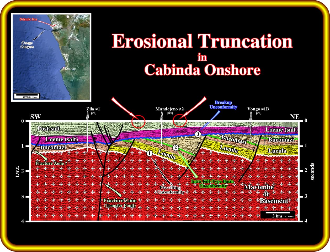
On this geological tentative interpretation of a seismic line from Cabinda onshore (North Congo Basin), the toplap geometrical relationships visible at surface, particularly around the location of Mandejeno ≠ 2, underline a recent uplift of the area. Similarly, the shallow depth of the rift-type basins is quite significative, because the organic matter of the organic rich lacustrine shales of Bucomazi Formation, reached in Mandejeno ≠2, is mature. This implies that the rift-type were buried at a much bigger depth that they are today. The infra-salt stratigraphy (margin infra-salt and rift-type basin sediments), as well as, the major unconformities (Pre-rifting unconformity, (1) ), Intra rift-type basin unconformity (2) and Breakup Unconformity (3) ) will be considered in detail later. Notice the presence a reactivated fracture zone (eastward of the Zila ≠1), which seems to border two different geological provinces. The reactivation of the fracture zones, which creates local compressional (anticlines) and extensional (grabens) structures, can be considered as a transpression , i.e., when a region of the Earth's crust experiences strike-slip shear and a component of shortening, resulting in oblique shear. (Transpression typically occurs at a regional scale, such as plate boundaries that have an oblique convergence, however, more locally, transpression can occur along strike-slip fault zones which are not perfectly planar.
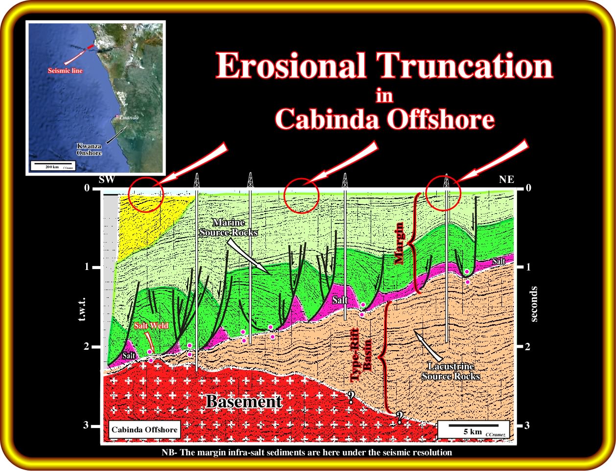
On this geological tentative interpretation of a seismic line of the conventional Cabinda offshore (see location in the map on the upper left corner of the plate), the obvious erosional toplap geometrical relationships corroborate the hypothesis of a Late Tertiary uplift of the proximal offshore. As anyone can perceive, the margin and rift-type basins sediments show, more or less, the same seaward tilting. In other words, the mapping of the bottom of the salt layer and associated salt welds (surface separating two stratal units formerly separated by salt and now in contact), can just be coherently (difficult to falsify) explained by an significant uplift. As in Cabinda onshore (previous plate), the depth of the mature source-rock intervals (supra-salt and margin sediments) is highly corroborate the important uplift of the area.
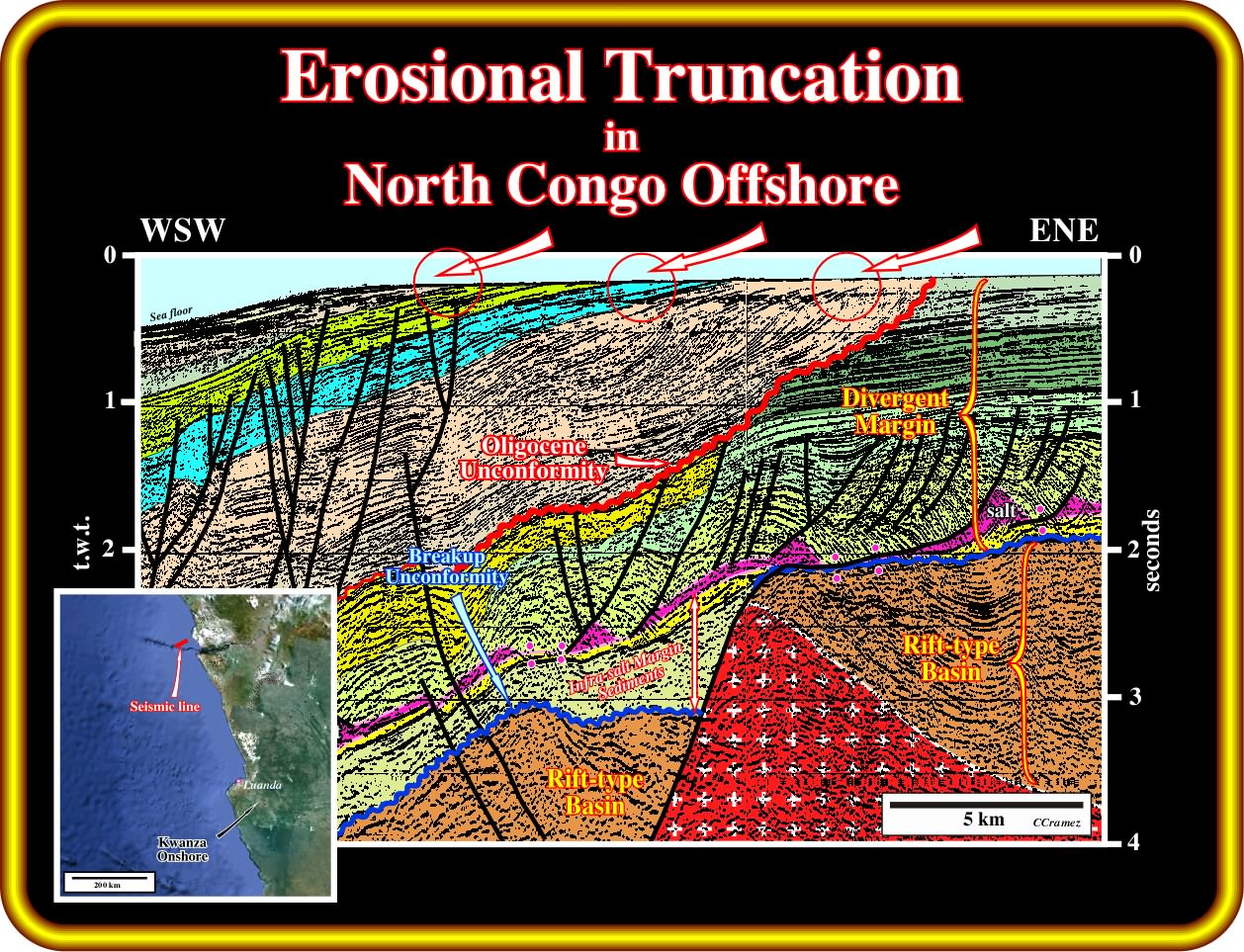
In this geological tentative interpretation of a seismic line of the North Congo offshore (seaward continuation of the Cabinda offshore), not only the Paleocene platform (in green in this tentative) is eroded, but the progradational sediments postdating the Oligocene unconformity as well. The toplap geometrical relationships are obvious. Take note that within the first progradational interval, the seaward progradation of the self break can be followed easily, which exclude the possibility of depositional toplaps (no erosion). However, one must take into account the change of environment. The pre-Oligocene sediments are mainly platform sediments, that is to say, they were deposited almost horizontally, what is not the case for the post-Oligocene unconformity sediments, which were, mainly, deposited on the continental slope and abyssal plain environments. In other words, the depositional dip of post-Oligocene sediments must be take into account. In any way whatsoever, the geometrical relationships, recognized on this seismic line, and the dip of the salt induced tectonic disharmony (bottom of the salt and associated salt welds), cannot refute the conjecture of a significant Late Tertiary uplift, on the contrary they corroborate it.
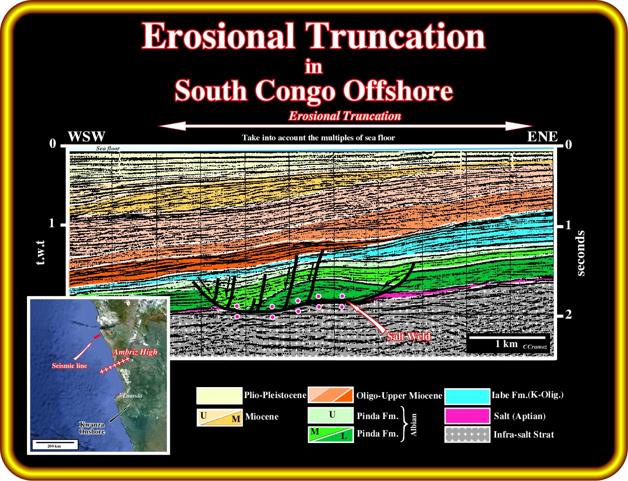
On this geological tentative interpretation of a seismic line of the conventional South Congo offshore, the Late Tertiary uplift is evident, but not too obvious. In fact, at the bottom of the sea, the toplap geometrical relationships are, partially, masked by the multiples of the bottom sea (peg legs). The bottom of the salt interval (and associated salt welds), as well as, all unconformities, bounding the different seismic intervals recognized on this tentative, were tilted seaward as a consequence of the uplift. On the other hand, the geometry of the unconformities (erosional surfaces controlled the eustasy and tectonics) and the continental encroachment sub-cycles suggest that uplift could be done in successive tectonic episodes. Notice that the eastward dip of the infra-salt strata favours the presence of rift-type basin sediments, but as we will see all along of this workshop, the interpretation of the infra-salt strata is more complicated and require a geological approach from the general to the particular and not from the particular to the general as it is often performed.
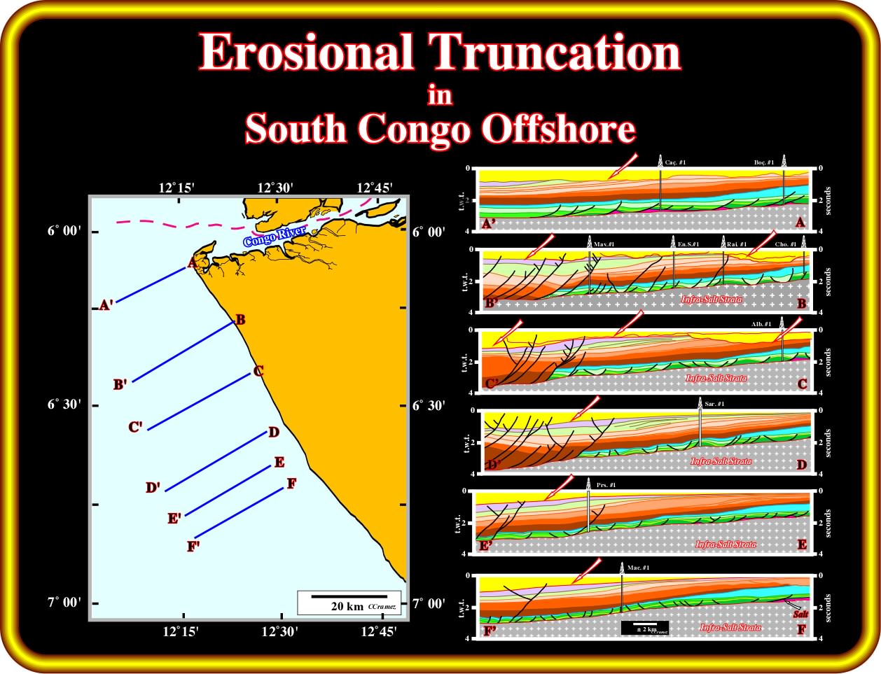
In this plate is illustrated a serialized set of geological tentative interpretations of seismic lines of the conventional South Congo offshore (North Angola offshore) which depicts the sedimentary unroofing induced by the Late Tertiary uplift. In fact, in the uppermost seismic interval (in yellow in the tentative interpretation), erosional unroofing is obvious and it is the more likely source for offshore Tertiary sediments away from the major streams and principally from the Congo river, which mouth seems to have change with time. Taking into account the westward dip of the salt induced tectonic disharmony, it is easy to notice that between certain lines it changes slightly, which suggests ten presence of fracture zones. In fact, in this area, as well as in all South Atlantic offshore, the fractures zones, which defined different geological and petroleum provinces, strike roughly NE-SW, that is to say, more or less parallel to the orientation these seismic lines. Consequently, the change of the dip of the bottom of the salt, between certain seismic lines, means that they belong to different geological provinces (bounded by major fractures zones).
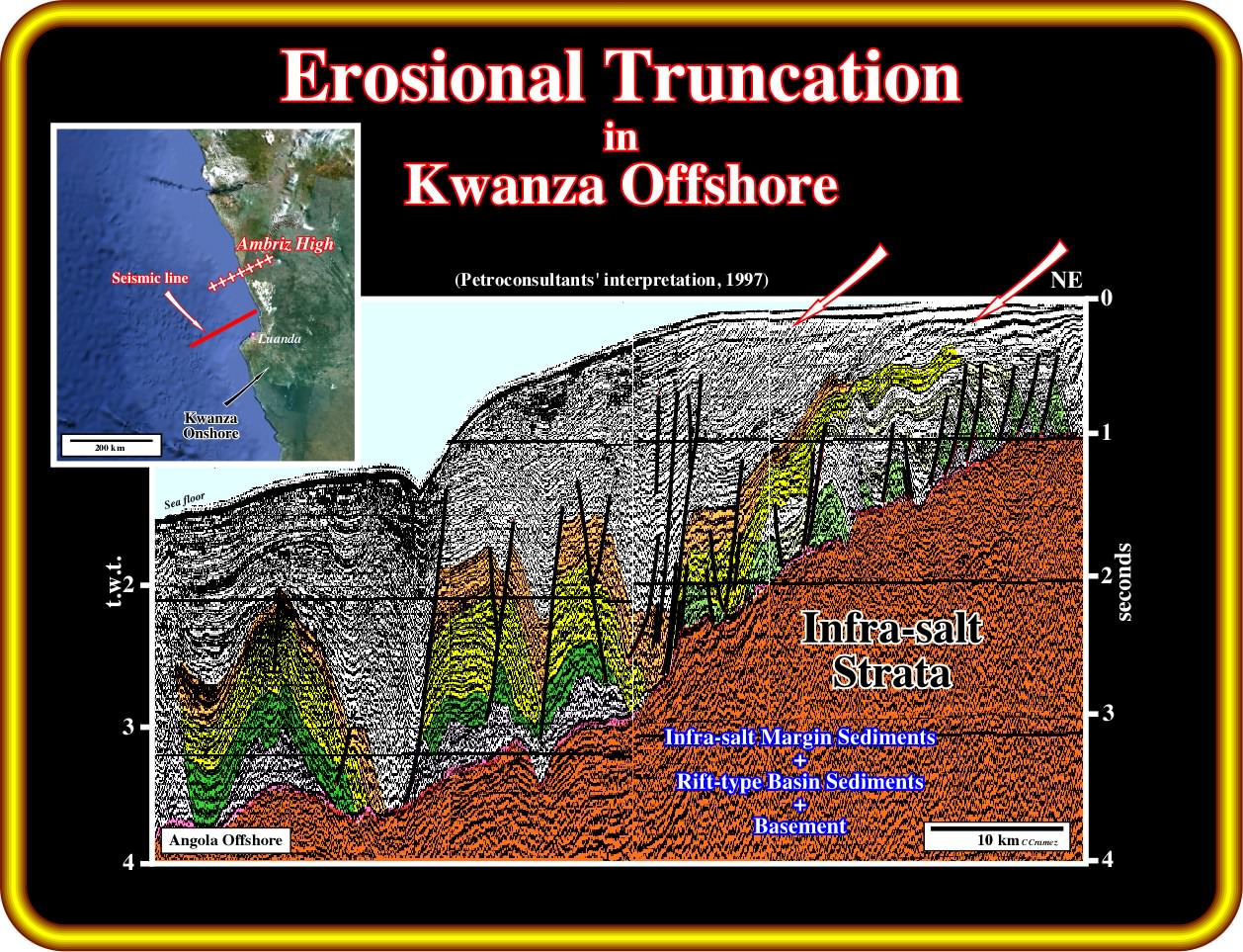
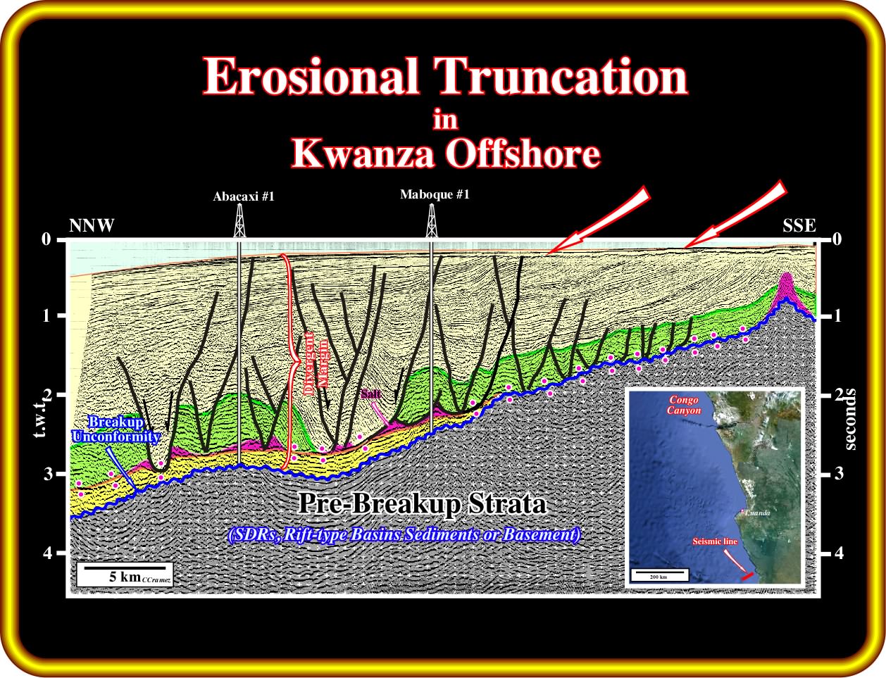
In this geological tentative interpretation of a seismic line of North Kwanza offshore (southward of the Ambriz Arch), the toplap geometrical relationships (erosional toplaps and not depositional toplaps), induced by the Late Tertiary uplift, are evident, at the bottom of the sea. Similarly, the magnitude of the seaward dip of the salt induced tectonic disharmony (top of the infra-salt strata), which separates the undeformed infra-salt sediments from the lengthened (deformed) supra-salt sediments, is highly significant. On this matter, it is interesting to notice that the basement (granite-gneiss with garnets, in this area) outcrops, in the Ambriz arch, which separates the South Congo basin from the Kwanza basin, not far from the shoreline (see location map on the upper left corner of this plate). As suggested by the seismic line, the continental platform (water depth less than 200 meters) seems to be the result of the unroofing of the uplifted sediments. On the other hand, the abrupt gradient change in water depth, associated with a submarine valley (on the left part of the line), seems to be induced by the reactivation a fracture zone (no picked in the Petroconsultant interpretation).
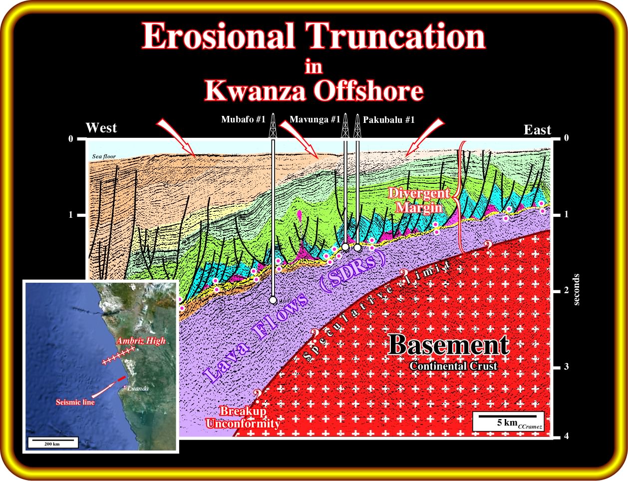
On this geological tentative interpretation of a seismic line of the conventional Kwanza offshore (northward of Luanda city), calibrated by the results of several exploration wells, the erosional toplap geometrical relationships are obvious. They are likely induced by the Late Tertiary uplift that took place all along the SW Africa. Similarly, the seaward dipping of the salt induced tectonic disharmony (seismic surface limiting the undeformed infra-salt strata from the lengthened salt and overburden) is a consequence of such tectonic uplift, which originated a meaningful relative sea level fall responsible for the erosional unroofing. Notice that the top of the basement, that here should correspond to the breakup unconformity is speculative. On the contrary, the subaerial lava flows, lying below the margin infra-salt sediments, which postdate the breakup unconformity (lower limit of the divergent margin), are calibrated by several exploratory wells, particularly, Mubafo ≠1, which was abandoned after perforate several hundred meters of subaerial lava flows (SDRs is the acronym of Seaward Dipping Reflectors). Here, again, as on the previous seismic line, the continental platform is, in fact, the result of the unroofing of the uplift sediments.
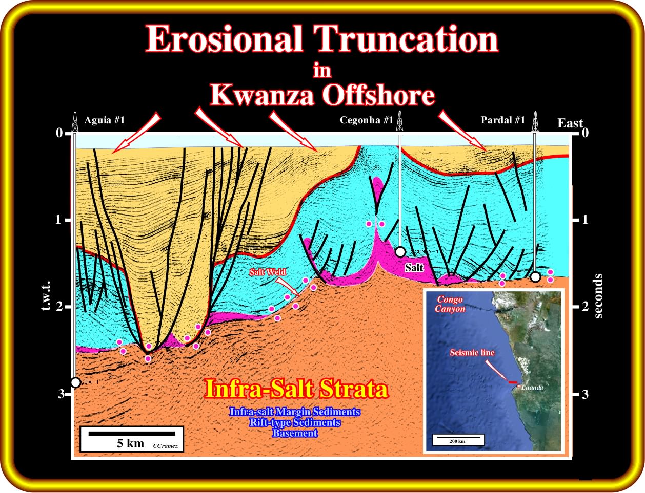
On this simplified geological tentative interpretation of a seismic line of the conventional Kwanza offshore passing through Pardal ≠1, Cegonha ≠ 1 and Aguia ≠ 1, the erosional toplap geometrical relationships (actually, reflexion terminations), at the bottom of the sea, are a consequence of the Tertiary uplift of the continent (Pangea substratum) and adjacent post-Pangea sedimentary prism. The reactivation of the fracture zones, perceived, but not picked, around Cegonha area (be aware of the dip change of salt induced tectonic disharmony) strongly squeezed (shortened) the salt and supra-salt sediments. The reactivation is probably independent of the uplift, which just enhanced the geometrical relationships of the seismic reflections. Take into account that the sediments fossilizing the Oligocene unconformity (in red, in this tentative interpretation) are deep water sediments (coloured in light ochre), i.e., basin floor fans (in onlap westward of the Cegonha ≠1) and slope shales., which depositional dip must be taken into account. It is interesting to point out, that in this area (block 6), where all exploratory wells tested turtle-back structure with negative results (heavy oil and bad reservoirs), any oil company had the courage to drill the basin floor fans visible at the bottom of the Oligocene unconformity eastward of the huge Tertiary deponent between Aguia ≠1 and Cegonha ≠1.
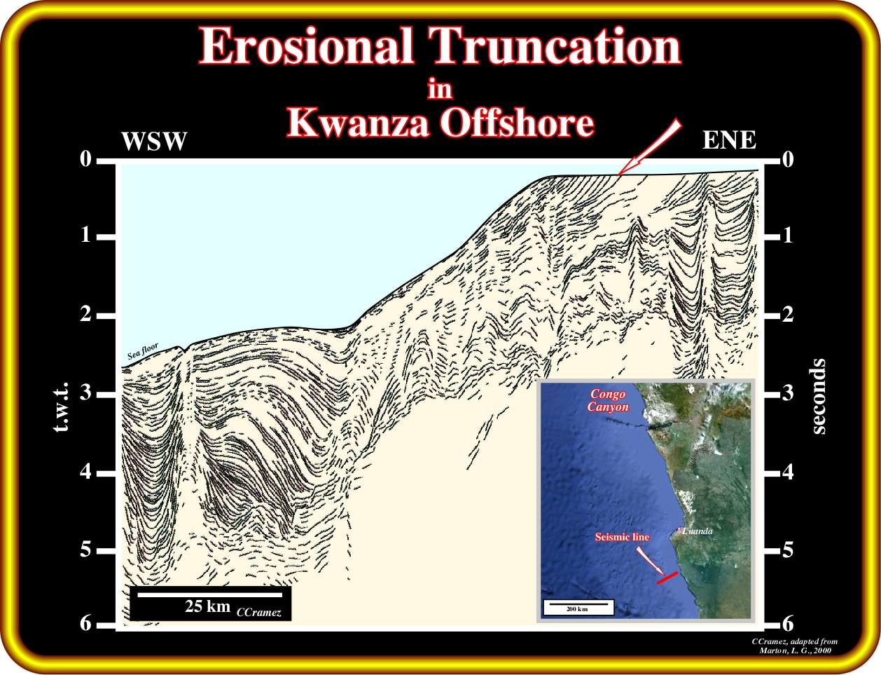
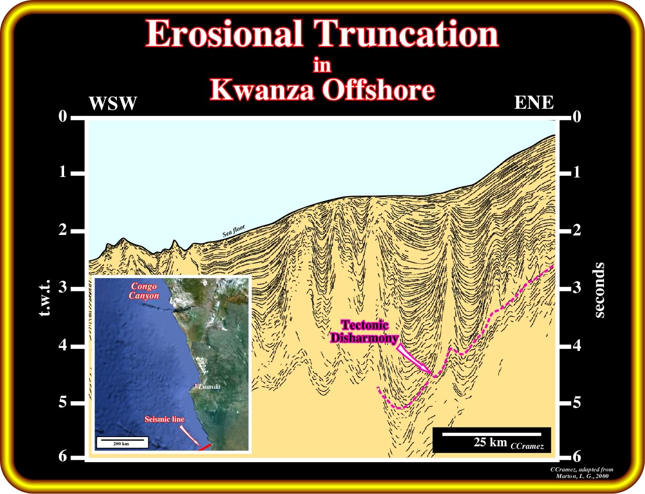
On this simplified copy of an offshore seismic line (the main seismic reflectors were underlined by pencil traces), located southward of Kwanza river mouth (taken from a paper of Marton et al. 2000 - Evolution of the Angolan Passive Margin, West Africa, with Emphasis on Post-Salt Structural Styles,Geophysical Monographs 115), the erosional truncation visible at the bottom of the sea, clearly, illustrates the consequences of the Late Tertiary uplift of the the continent and contiguous post-Pangea sedimentary prism. Notice, again, that the continental platform is just the result of the erosional unroofing of the uplifted sediments. In fact, the bathymetry can be easily explained by the Late Tertiary uplift (continental platform) and the presence of a fracture zone, more or less, reactivated that is responsible for the break in the water-depth in the continental slope. Notice, that even taking into account the seismic artefact induced by the lateral changes of the water depth, the geometry of the tectonic disharmony is similar to the geometry of the sea floor.
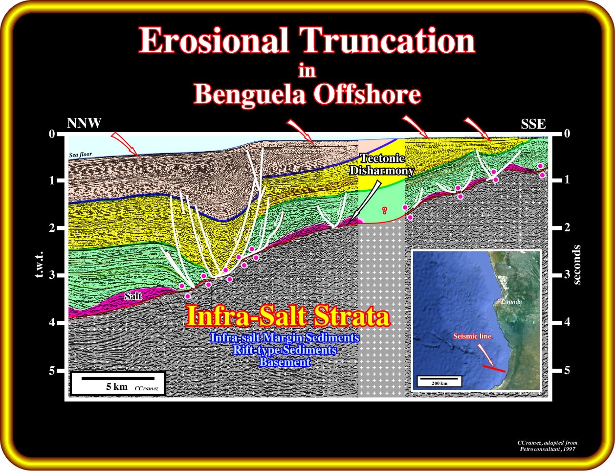
As illustrated, the erosional truncation induced by the Late Tertiary uplift of the SW Africa is, also, obvious in the conventional Benguela Offshore (southern part of the Kwanza basin, that certain geoscientists label Benguela basin). The reflection terminations, at the bottom of the sea, are, unquestionably, erosional toplaps created by erosion produced by the relative sea level fall that follows the uplift of the area. The breakup unconformity (in dark blue) separates the Pangea lithosphere (basement or pre-Pangea sediments) and rift-type basin sediments from overlying margin sediments, in which, the salt layer can be used to differentiate margin undeformed infra-salt sediments from deformed supra-salt sediments. Take note, that as we will see later, different geological tentative interpretations can be proposed to the infra-salt strata (general term that includes all rocks below the salt), particularly to the position of the breakup unconformity and the facies (lithology) of the crust (continental, subaerial volcanic or oceanic). Here, we are are just interested in the Late Tertiary uplift.
On this copy of a regional seismic line of the Benguela deep offshore, in which the main seismic reflectors were, just, underlined by pencil traces, the Late Tertiary uplift is not corroborated by toplap geometrical relationships at the bottom of the sea. However, the geometry of the tectonic disharmony (bottom of the salt for some geoscientists) strongly suggests a significant uplift of the eastern part of the area where this line was shot, which is confirmed by the old seismic line illustrated on the next plate. It is interesting to notice that few salt domes seem to reach the bottom of the sea. On the other hand, notice that infra-salt reflectors dip seaward, which favour the hypothesis of an absence of the rift-type basins and probably continental crust, where the rift-type basins can develop.
On this simplified geological tentative interpretation (partially proposed in 1997 by Petroconsultant) located on the southernmost part of the Kwanza basin (South Benguela), the erosional toplap geometrical relationships striking at the bottom of the sea all along of the platform, as well as the upper continental slope, corroborate the geological conjecture of a significant uplift of the SW Africa continent and contiguous sedimentary prism during the Late Tertiary. Similarly, the geometry (dip) of the tectonic disharmony suggests the same tectonic event. Notice that different geological interpretations of the infra-salt strata are possible. They will be discussed later. For the moment we are just interested in the Tertiary uplift of the continent and contiguous sedimentary basins, which has great consequences in the development and exploration of the different petroleum systems.
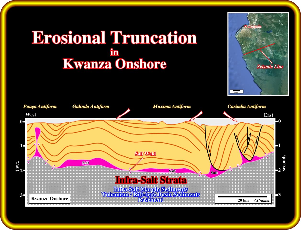
On this geological tentative interpretation of an old composite seismic line of the Kwanza onshore (60's), passing through known antiform structures Carimba, Muxima, Galinda and Puaça, the Tertiary erosional truncation induced by a significant relative sea level fall created mainly by the uplift of the proximal area of the basin, created erosional toplap geometrical relationships (reflection terminations) at the ground surface. Do not forget than an antiform is extensional structure, that is to say, a lengthened structure. Contrariwise, an anticline structure is compressional, i.e., structure is created by a sedimentary shortening. As depicted, all infra-salt strata are grouped in a unique geological unity, which can be considered as the infrastructure of the salt interval. These infra-salt strata will be studied later.
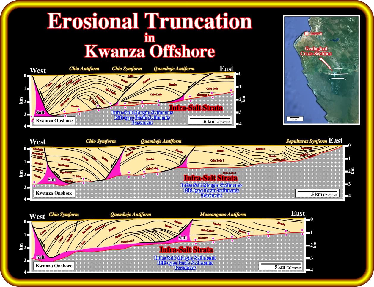
These three old geological cross-sections were build upon field work along the seismic profiles and later controlled by the geological tentative interpretation of un-migrated seismic lines and stratigraphic result of the Chio ≠1 and Quembeje ≠1. Admittedly, the erosional unroofing, which created obvious toplap geometrical relationships, cannot be explain just by halokinesis, i.e., a significant Late Tertiary uplift of the area is absolutely indispensable not only to explain the geometry of the sedimentary interfaces, but the maturation of the organic matter of the organic rich intervals recognized in the wells, as well. In fact, the present depth of such organic rich intervals is insufficient to explain the maturation of the organic rich, which implies an initially appropriated burying followed by a more or less recent uplift (see later).
(iii) Reactivation of salt steps and fracture zones
The Late Tertiary uplift of the continent and contiguous sedimentary prism (basement, rift-type basins and overlying divergent margin) seems to have provoked the reactivation of salt steps (infra-salt topographic features associated with weak and faulted zones of the continental crust, which are mainly fossilized by onlapping of salt strata) and major fractures zones (associated with transform faults and changes in the rate of sea floor spreading), as illustrated in the next plates. Take note, that for a lot of geoscientists, the fracture zones, which correspond to pre-Pangea or even Precambrian geological lineations (broken or damaged zones) that not only control the breakup of the lithosphere but the sea floor spreading as well.
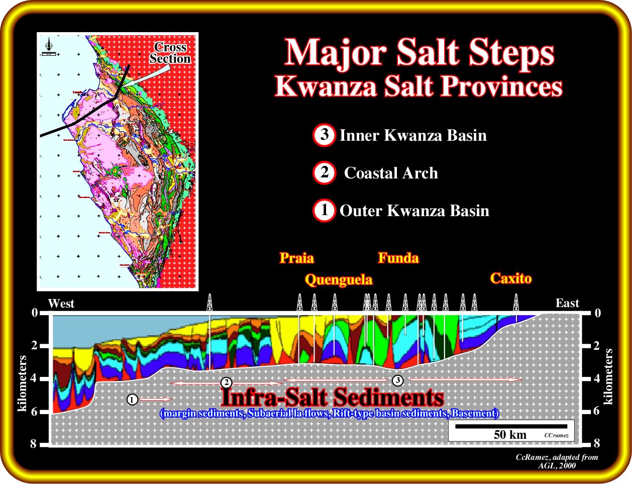
As depicted on this regional geological cross-section of the Kwanza basin (see location on the geological map), several infra-salt topographic steps (ramps) are recognized. These steps were,probably, more or less, reactivated during the Late Tertiary uplift, inducing a significant erosional unroofing, which created an enormous increasing of the terrigeneous influx, particularly, outward of the mouth of major streams. These infra-salt steps, which were fossilized by evaporitic strata, define three major salt provinces or salt sub-basins in Kwanza basin : (i) The Outer Kwanza Basin (1), where the salt thickness reached more than 3000 meters ; (ii) The Coastal Arch, in which the maximum thickness of the salt reached around 650 meters and (iii) The Inner Kwanza Basin, which, roughly speaking, corresponds to the Kwanza onshore, where the maximum salt thickness was, according to the geological reconstitutions, around 2300 meters. The largest infra-salt step (around 1425 meters), between the Outer Kwanza Basin and the Coastal Arch, defines, roughly, what several geoscientists call the Atlantic Hinge Zone. Admittedly, the onlapping of the salt over the infra-salt sediments, which is, more evident along the major steps, means that the bottom of the salt is not synchronous all along the basin. Consequently, one can not tell that the bottom of the salt was continuous and, more or less, horizontal, what the majority of the geoscientists working in Angola have always assumed.
In this geological tentative interpretation of a seismic line of the Angola deep offshore, the reactivation of the major infra-salt step (around 1400 meters high) within the outer Kwanza basin is obvious ( salt step bounding the Coastal Arch, that is to say, the Atlantic Hinge Zone, is located eastward, but is no visible on this portion of the seismic line). This infra-salt step is characterized by an onlap surface of the evaporites fossilizing the unconformity (erosional surface) developed at the top of the (i) Margin infra-salt sediments (when they exist) ; (ii) Subaerial lava flows, which postdate the breakup unconformity ; (iii) Rift-type margins sediments or (iv) Basement. Notice, that as sedimentation takes place above the salt, the salt starts to move seaward. If the sedimentation rate is insufficient to cover the bathymetric escarpment (infra-salt steps), the sediments onlap the step and are translated basinward after deposition, producing a landward dipping package of onlapping strata. The distance from a given onlap to the step records the amount of translation. The erosional unroofing produced by the relative sea level fall created by the Tertiary uplift is enhanced by the squeezing (shortening) of the salt structures and associated salt glacier.
As said previously, fracture zones are zones of fragility of the continental crust, which can favour the breakup of the Pangea lithosphere (when parallel to the σ2 of the stress ellipsoid inducing the breakup) and sea floor spreading (when parallel to the σ3). In Kwanza and Congo basins, as well as in other divergent Atlantic-type margins, the fracture zones are directly or indirectly associated with the transform faults and changes in the rate of sea floor spreading. On other words, they are, more or less, perpendicular to the infra-salt steps and control the oceanization (see below).
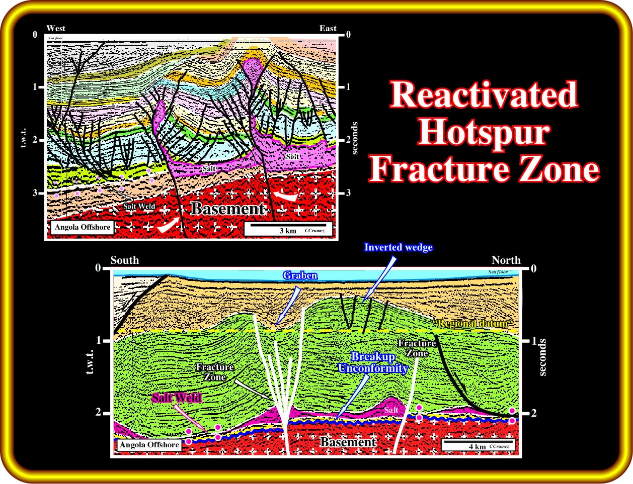
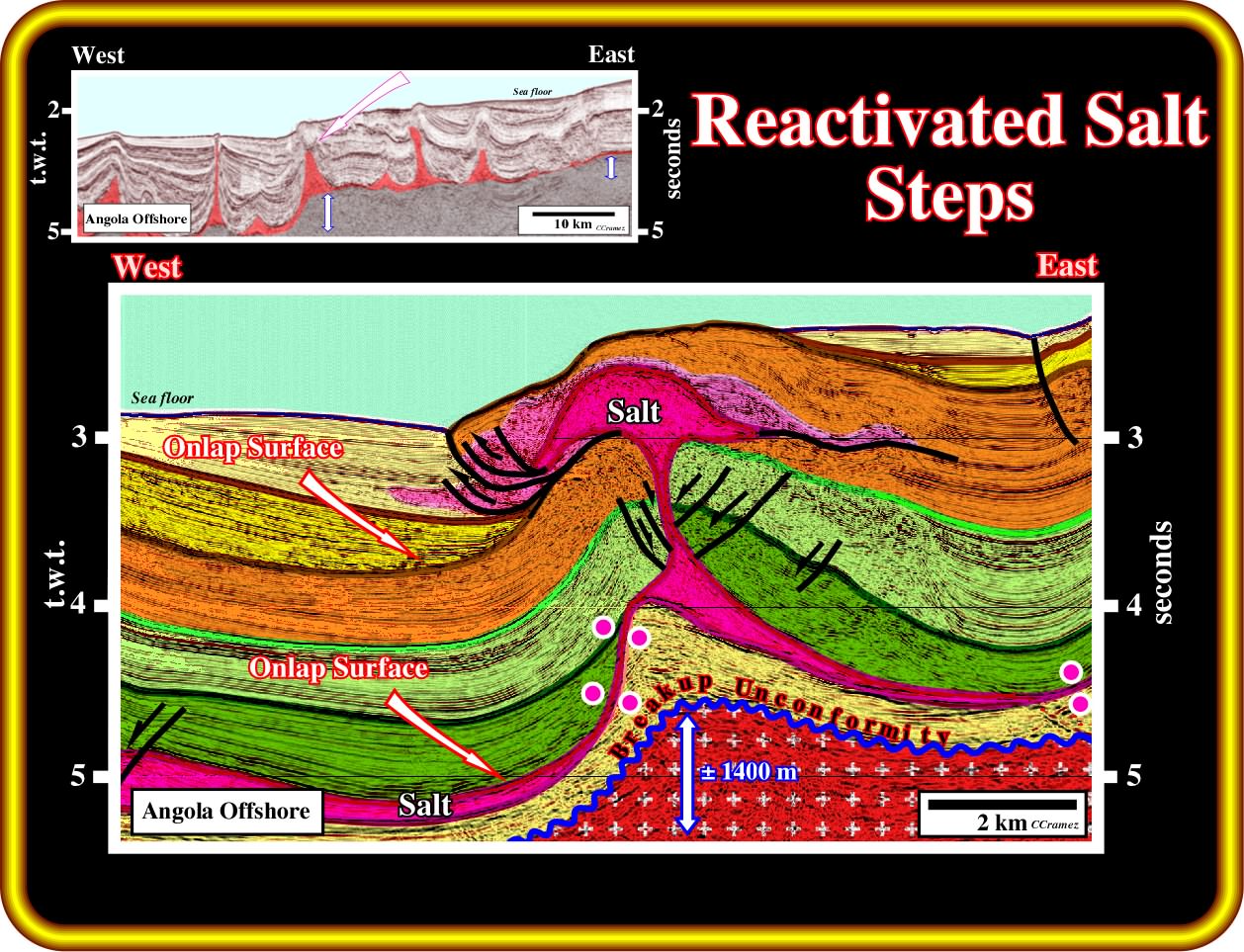
On these geological tentative interpretations of seismic line crossing the Hotspur fracture zone (see location in next plate), a late reactivation of the fracture zone is quite evident. In fact, the bottom of the salt layer, and associated salt welds, are displaced as well as the basement (lower seismic line). On the other hand, the shrinkage of the flanks of the diapirs and the reverse geometry of the old normal faults, corroborate the development of local compressional tectonic regimes, responsible by the local shortening and uplift of the sediments creating particular tectonic inversions. One cannot exclude that such reactivations are also associated with the regional Late Tertiary uplift. However, one cannot forget that the uplift created by the reactivation of the fracture zones is associated with a sedimentary shortening, while the Tertiary uplift induced mainly a lengthening of the sediments. In other words, the first create anticlines, while the second creates antiforms.
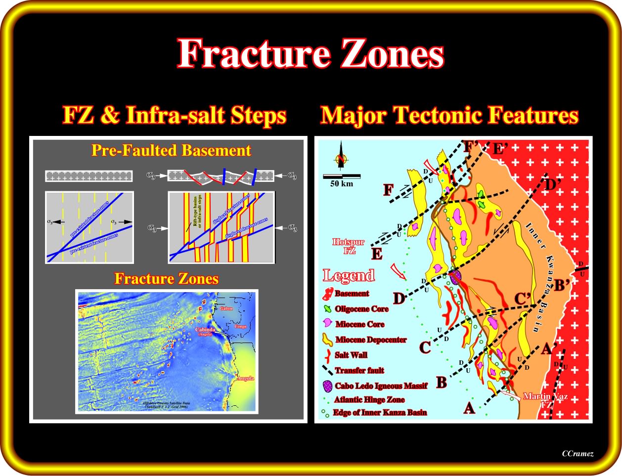
Contrariwise to what is suggested in recent American publications, in Kwanza basin, and particularly in Kwanza onshore, the major fracture zones and associated geological provinces, are known since the 60's, when the geoscientists of Petrangol (Petrofina) explored the basin (just the name of the fracture zones has changed). As recognized on the left (Major Tectonic Fractures), the fractures zones, which seem to correspond to old Pangea fragility zones, strike roughly WSW-ENE, i.e., almost perpendicularly to the infra-salt steps (underline by green and white dotted lines. On the other hand, the fracture zones are older than the North-South infra-salt steps. However, the fracture zones when reactivated, probably during the regional Late Tertiary uplift of the continent and contiguous sedimentary prism, displaced, apparently, the infra-salt steps, as it is the case for the Hotspur fracture zone (the old Barreirinhas fault zone of Xavier Le Pichon, 1968), which played as an extensional strike slip fault with local shortening structures. The displacement mechanism of the infra-salt steps is similar for that of lengthening of a pre-faulted substratum, illustrated on the left sketch (adapted from an old paper of Jean Letouzey).
(iv) Kübler index and vitrinite reflectance
The first time I and my Total CAP's colleagues heard about the Tertiary uplift of the Kwanza onshore was in 1968, when B. Kübler (a geoscientist of Elf-Aquitaine, who became professor at University of Neuchâtel, in Switzerland) explained us that the organic rich shales of the Cambambe formation could not be the source-rock of the oil found by Petrangol (Fina), since the crystallinity of the illite indicates that the shales reach the zone of anchimetamorphism, which implies that the basin was strongly uplifted. According to him, the illite crystallinity index (or Kübler index) could be applied in petroleum exploration to detect diagenetic stages (primarily to characterise the ultimate evolution stages before metamorphism, i.e., to identify the transition from dry-gas phase to unproductive rocks, that is to say, the transition from deep diagenesis to anchizone.
In fact, currently, the most common method used for determining grade in metapelitic sequences is the Kübler index of illite crystallinity, which measures changes in the shape of the first basal reflection of dioctahedral illite-muscovite at an X-ray diffraction (XRD) spacing of approximately 10 A (obtained from oriented clay specimens). The Kübler index, first proposed by Kübler (1964) and refined by Kübler (1967, 1968) and Dunoyer de Segonzac et al. (1968), measures the full width at half maximum intensity (FWHM) of the first, 10 Å, X-ray powder-diffraction peak of dioctahedral illite-muscovite (i.e. the Scherrer width), as measured on the <2 μm size-fraction of air-dried clay specimens using Cu-Kα radiation.
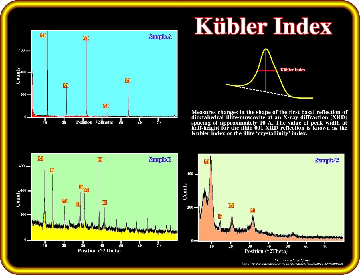
This plate illustrate representative XRD (X-ray diffraction) spectra of muscovite shows the variability in crystallinity based on the Kübler Index. In the sample A, the Kübler Index is 0.1 (epizone). In the sample B, the Kübler Index is 0.3 (anchizone) and in sample C, the Kübler Index = 1.0 (diagenetic zone). Major peaks are muscovite (M), dickite (D) and hematite (H). Notice that, in terms of Kübler index, the epizone is limited between 0.1 and 0.25, the anchizone between 0.25 and 0.425 and the diagenesis with values higher than 0.425. Kübler (1967) selected these limits on the basis of certain mineralogical changes: the lower anchizone limit coincides with the upper-grade limit of the existence of liquid hydrocarbons and the dickite to pyrophyllite transformation; the upper anchizone limit is associated with the appearance of greenschist facies minerals, such as chloritoid.
When B. Kübler told Total CAP's geoscientists that the organic rich shale of the Cambambe formation could not be the source-rocks of the oil discovered in Kwanza onshore, he announced us, that in spite of the fact of their present shallow position, the more likely source-rocks were the organic rich transgressive Cretaceous calcareous shales, since the crystallinity of illite and the vitrinite reflectance (key method for identifying the maximum temperature history of sediments in sedimentary basins, i.e., a maturity indicator since reflectance of vitrinite macerals is proportional to thermal maturity) suggested that the organic matter had reach maturation. Again, a regional important burial followed by a late uplift of the continent and contiguous post Pangea sediments was required to place the potential source-rocks at so shallow depth.
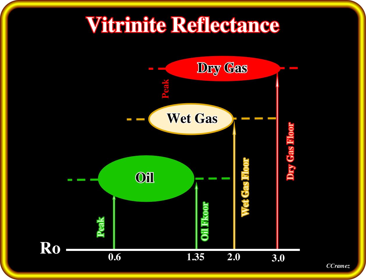
The most common used technique for maturity determination of the organic matter of a potential source-rock is the vitrinite reflectance (Ro), which measures the intensity of reflected light, from polished vitrinite particles, reported as mean reflectance percentage. This analytical method was developed to rank the maturity of coals and is now used in other rocks to determine whether they have generated hydrocarbons or could be effective source rocks. The reflectivity of at least 30 individual grains of vitrinite from a rock sample is measured under a microscope. The measurement is given in units of reflectance, % Ro. Values ranging from 0% Ro to 1.3% Ro indicate a possible oil generation, values between 1% and 2% indicate wet gas generation and values between1.2% and 3% indicate a dry gas generation. Values hiher than 3% suggest that the organic matter reached the zone of anchimetamorphism.
To finalize this subject let's show the map illustrating the more likely amounts of Late Tertiary uplift in Kwanza basin, proposed by AGL, in the AAPG metting of Cape Town (2008).
According to the authors (AGL), The Kwanza rim and Precambrian hinterland were exhumed between 1 and 4 000 meters, but the tilting did not appreciably affect the northern coastal plain of Kwanza basin. The largest uplift was in the Precambrian hinterland (around 2 - 4 kilo meters). In Cabo Ledo area, the uplift was around 100 - 1500 meters. A small Neogene uplift (150 - 200 meters) tilted the shelf and upper slope seaward. In more detail, one can say that between Quenguela and Funda decanters (between fractures zones D and C, go three plates back and see fracture zones), there was exhumation, as well as in Chio and Quembeje area (eastern zone so ut ward of the D fracture zone), Muxima area and locally in Cabo Ledo are (see previous plates on this subject).
Exercise 1:
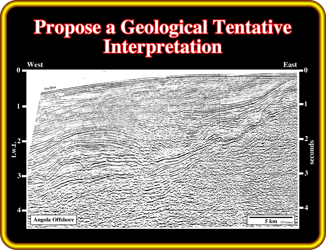
In your geological tentative interpretation give particularly attention to:
(i) The salt induced tectonic disharmony, picking all primary salt welds ;
(ii) The breakup unconformity ;
(iii) The pre-rifting unconformity, that is to say, we must individualise the rift-type basins, if they are present, which predate the breakup of the Pangea lithosphere ;
(iv) The pre-raft and rafts structures ;
(v) The Oligocene Unconformity and the associated basin floor fans ;
(vi) The multiples of the sea floor.
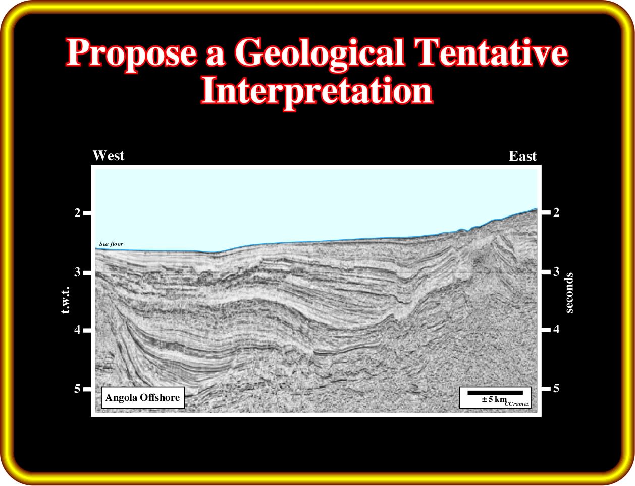
Finally, do you see on this line feature corroborating the Late Tertiary uplift ? Justify your answer.
Exercise 2:
In your geological tentative interpretation of this line, you must start by picking the bottom and top of the salt and recognize infra-salt steps and translation onlap surfaces.
Are the infra-salt steps reactivated ?
What is the more strike of such topographic steps ?
Do you see reverse faults affecting the salt ?
If yes, where and how do you explain them ?
Exercise 3:
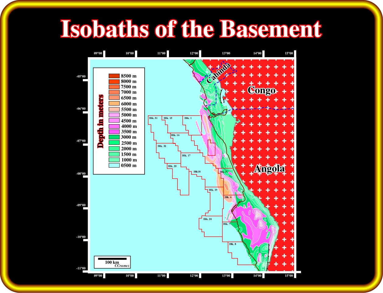
Take a look at this isobath map of the basement. Knowing that the Ambriz arch separates the Congo and Kwanza basins, what differences do you see between this two basins.
Assuming that this map is mimetic of salt deposition how many salt decanter do you expect to find in Kwanza basin (including the deep offshore) and in Congo basin ?
Tell this map something about the Late Tertiary uplift ?
Exercise 4:
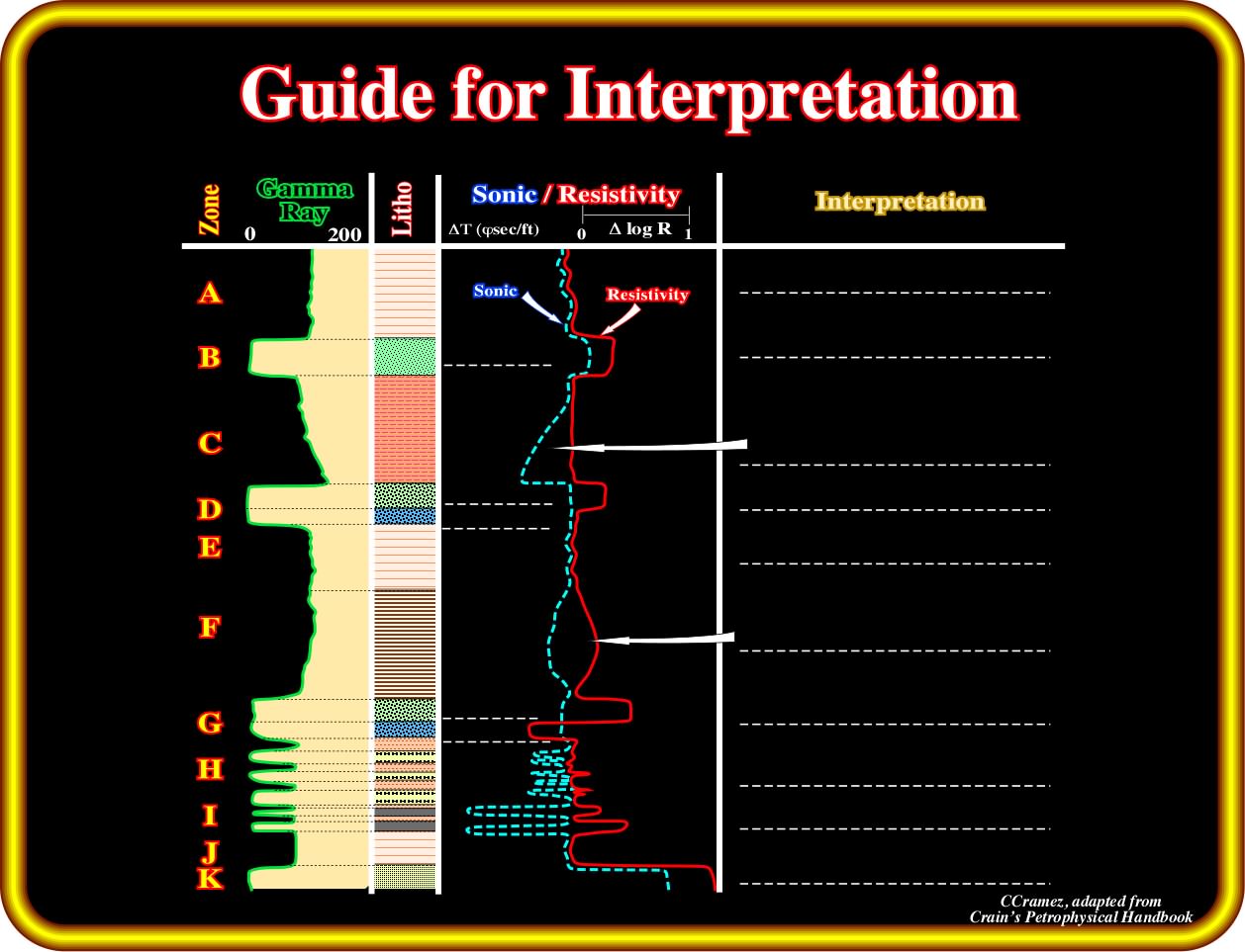
As in this workshop we will evaluate the hydrocarbon potential of the margin infra-salt sediments, it is absolutely indispensable to know how to recognize on the electrical logs the organic rich intervals and those where their organic matter reaches maturation. This is the subject of this exercise. In the above plate are illustrated the gamma ray, the sonic and the resistivity logs (the sonic is aligned on the top of the logarithmic scale resistivity log, so that the sonic curve lies on top of the low resistivity shales). The overlay is created by tracing or "overlaying" the deep resistivity curve (on a logarithmic scale) on top of a porosity log (sonic, density, or neutron), and shifting the resistivity log sideways until it lines up with the porosity curve in an "obvious" water zone). Knowing that : (i) The low resistivity shales are considered to be no source-rocks and are unlikely to be gas shales ; (ii) The shales or silts with generating potential show considerable cross over between the sonic and resistivity curve ; (iii) When GR deflects to the left, the zone is clean and might be a reservoir quality rock ; (iv) When GR deflects to the right, the zone is usually shale (not a reservoir quality rock) ; (v) Porosity logs are scaled to show higher porosity to the left and lower porosity to the right (clean and porous is good, so compare the GR to the porosity log) ; (vi) Resistivity logs are scaled to show higher resistivity toward the right ; (vii) Higher resistivities mean hydrocarbons or low porosity ; (viii) Low resistivity means shale or water zones. So clean+porous+high resistivity are good.
In the interpretation column, you must place the following sentences in the dashed lines:
a) Oil or Gas ; b) Reservoir tight ; c) Non source rocks ; d) Reservoir low porosity ; e) Oil ; f) Water ; g) Immature source-rocks ; h) Reservoir ;
i) Oil ; j) Water ; k) Mature source-rock ; l) Coals ; m) Coal ; n) Non source-rock ; o) Reservoir high porosity ; p) Mature source rocks.
to continue press
next
![]()