
2) How the South Atlantic Ocean was opened?
2) How the South Atlantic Ocean was opened?
The understanding of the potential petroleum systems (a pod of active source-rock and all genetically related oil and gas accumulations, including all the geologic elements and processes that are essential if an oil and gas accumulation is to exist) in Congo and Kwanza basins, particular those located in the infra-salt strata (margin infra-salt, rift-type basin sediments and basement rocks) requires the acquaintance of the major tectonic and sedimentary events associated with the opening of the South Atlantic Ocean.
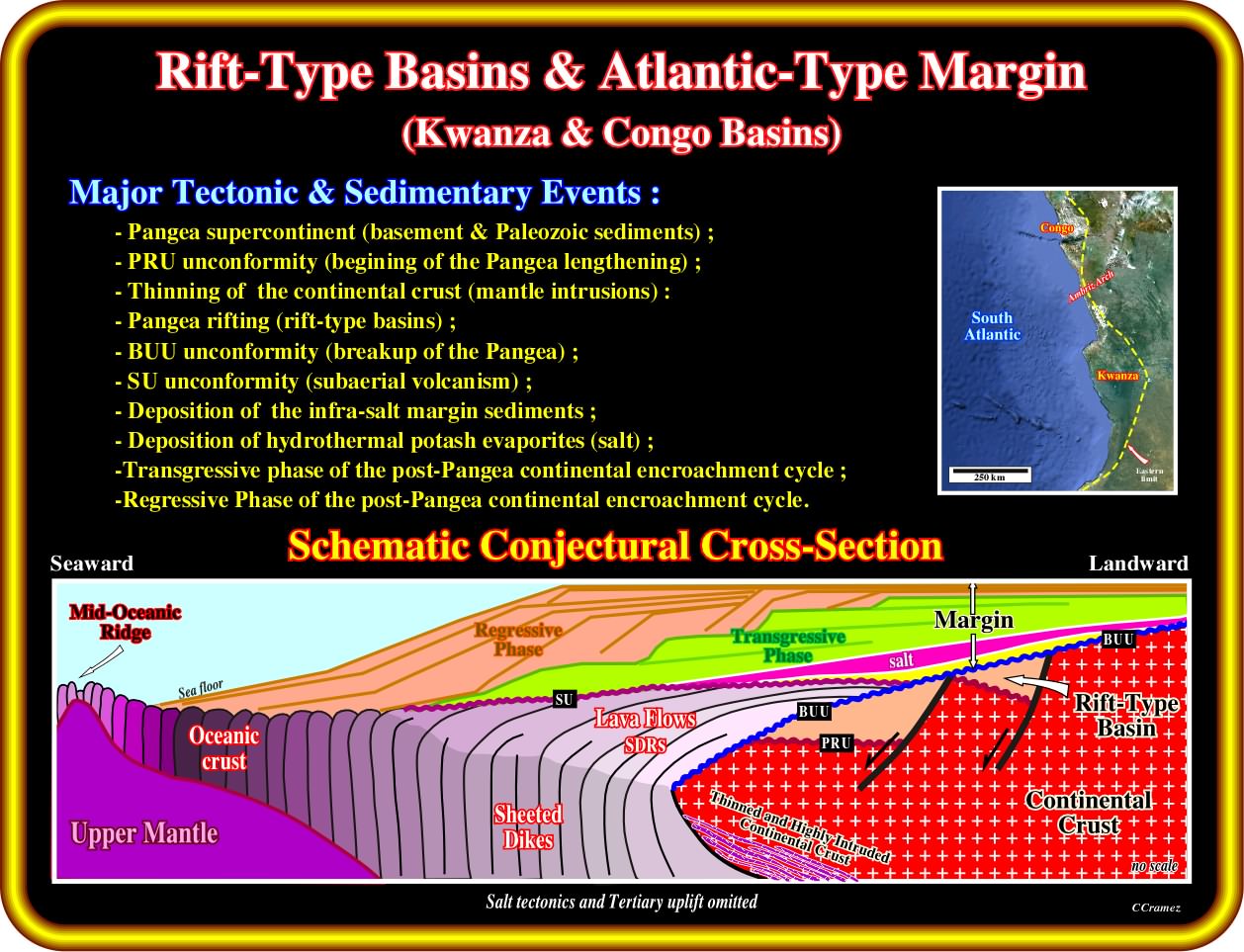
This schematic geological cross-section of Angola offshore (Congo basin) is representative of the divergent continental margins Atlantic-type (Kwanza basin, as we will see later, is slightly more complex, since there are, at least, two major salt depocenters). It illustrates the main geological features allowing the understanding of the different potential petroleum systems : (i) Pre-Pangea Sediments (Basement and Paleozoic sediments), which are bounded by the pre-rifting unconformity (PRU) ; (ii) The rift-type basins, which are developed during the lengthening and thinning of the Pangea supercontinent ; (iii) The breakup of lithosphere, which takes place along the thinning and highly intruded continental crust, underlined the breakup unconformity (BUU), which highlight the upper limit of the rift-type basins, in which organic rich (organic matter type I) lacustrine shales (parallel internal configuration) are potential source-rocks ; (iv) The breakup unconformity (BUU), which is fossilized by subaerial volcanism (lava flows) dipping and thinning continentward (SDRs) or by margin infra-salt sediments, which can form huge depocenters (called in a descriptive manner, by some geoscientists, "sag basins") ; (v) The seaward dipping reflectors (SDRs), which do not have any generating hydrocarbon potential (5 m of lacustrine shales are known, just, in Austral basin) ; (vi) The Angola-Congo salt basin (coalescence of different salt ponds), which is a twin of the Brazilian salt basin (both salt basins have always been individualized) ; (vii) The transgressive (backstepping) and regressive (forestepping) phases of the post-Pangea continental encroachment cycle ; (v) Potential marine source-rocks (organic matter type-II), linked with the interface between the transgressive and regressive phases ; (vi) Potential dispersive source-rocks (organic matter type III), which are, often, possible in the regressive interval.
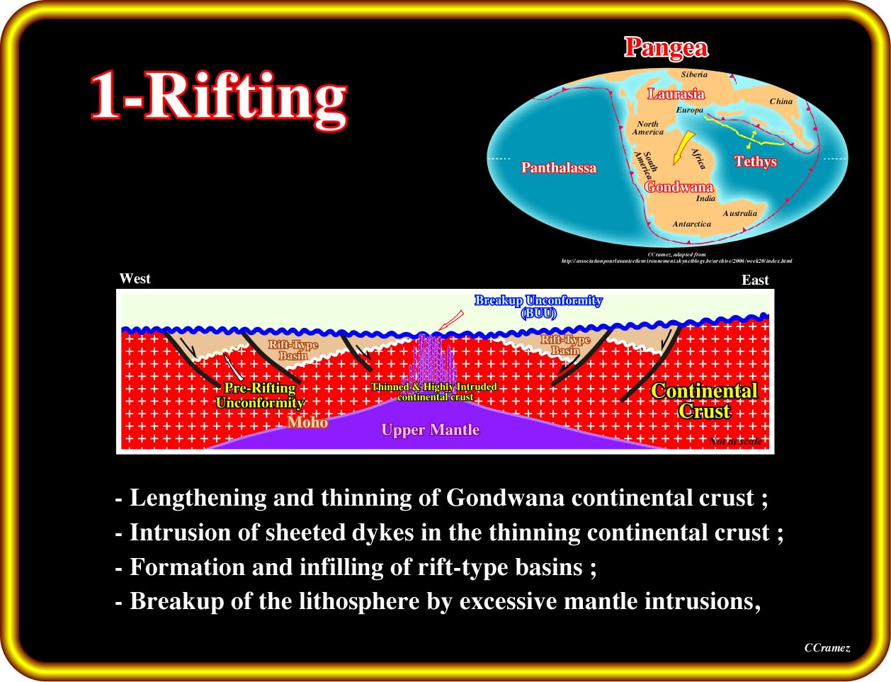
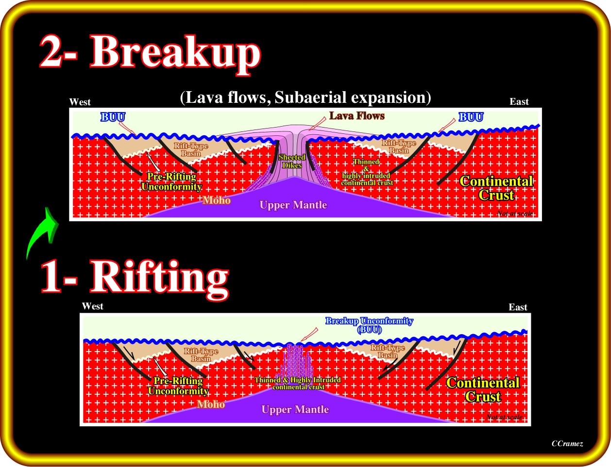
During the rifting Phase (between 135-115 Ma), during which the Gondwana continental crust was lengthened and thinning, the lithospheric breakup was closely linked to underlying mantle plumes. Each plume of upwelling asthenosphere heated, elevated, magmatically underplated and stretched a dome of overlying lithosphere. Stretching created asymmetric rift-type basins along the axis of the future ocean. As the lithosphere thinned by stretching and heating, igneous activity became increasingly common over time and nearer to the axis of rupture. After continental crust was stretched to a β factor of ≈ 2, abundant gabbroic melts were emplaced as dike swarms and sills in the extending crust. Eventually, before reaching a theoretical limit of β ≈ 4.5, rapidly stretched and magmatically injected continental crust broke up (breakup volcanism at ± 135-130 Ma). As the continental crust dispersed, basaltic crust began to accrete and Neocomian flood basalts were extruded subaerially. In other words, the breakup of the continental crust corresponds just to a change in composition due to injection of mantelic material. In fact, since the injected material becomes predominant, the crust is anymore continental, but volcanic and geoscientists said that the crust continental broke up.
It is important to notice that the lengthening of the Pangea lithosphere ended with the breakup, which age change along the margin. All rift-type basins are limited between the pre-rifting unconformity (PRU) and the breakup unconformity (BUU). A parallel internal configuration of the rift-type basins (rate of extension higher than rate of deposition) favour the deposition of organic rich lacustrine source-rocks (potential source-rocks). Since 2000, the large majority of geoscientists, particularly those working in the hydrocarbon exploration in South Atlantic offshores, knew that the predict organic rich sediments (potential source-rocks) dipping seaward in Angola, Namibia, Brazil and Argentina offshores, became, after drilling, sterile subaerial lava flows. The lava flows (by definition subaerial, since lava froze under water) postdate the breakup unconformity. On the other hand, as each injection of a dyke represents one increment of subaerial spreading (becoming, later, sea floor spreading), each dyke was normally intruded into earlier dykes.
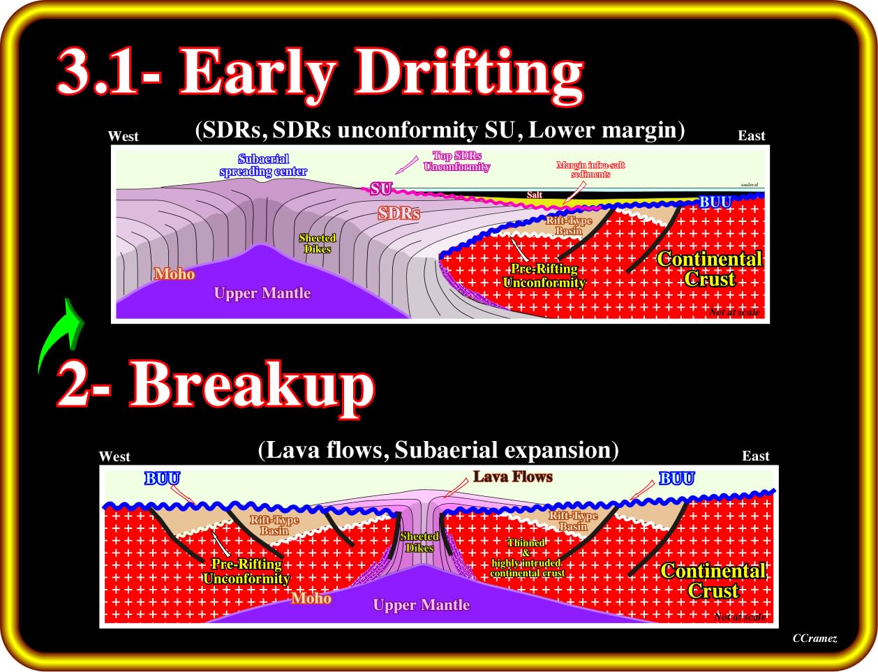
Lava flowed from subaerial spreading centres toward the continent across the distal rift-type basins. For the most part, subaerial spreading centres poured out extensive lava that flowed and thinned toward the continent. Vertical stacking of flows masks magnetic reversals including those in the underlying sheeted dikes, so this type of basaltic crust is magnetically quiet. As the underlying lithosphere cooled, thermal subsidence lowered the lava flows below sea level. Environments became marine, and the spreading centre submerged to become an oceanic ridge. Lava flows no longer flooded laterally because they froze rapidly under the sea. The oceanic spreading centre spread by injection of sheeted dikes. This geometry allows magnetic anomalies in submarine sheeted dikes to be more easily identified by potential field data than anomalies within or below the stacked subaerial flood basalts.
As the landward flowage of the volcanic material is discontinuous (in time and space), disconformities (not unconformities in the sequential stratigraphy sense) between set of lava flows are possible, as well as, thin sedimentary intercalations, generally without hydrocarbon potential. Nevertheless, few meters of organic rich lacustrine shales are known in Austral basin (Argentina onshore).
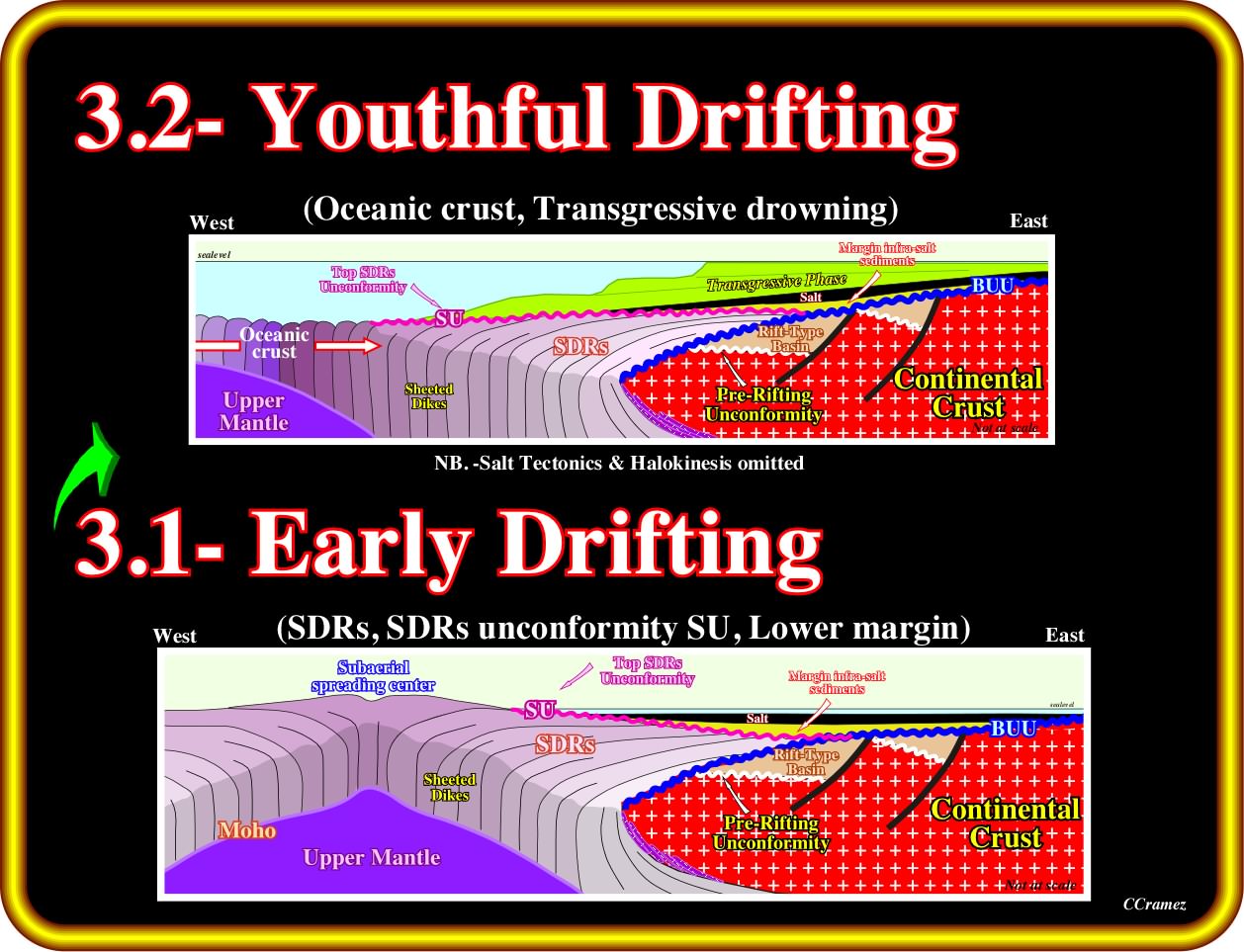
During the drifting transgressive phase (± 115-85 Ma), the Aptian evaporites or sandstones mark the onset of major transgression that continued until the end of the Cenomanian-Turonian. Transgression was driven partly by eustatic rise of sea level due to increased oceanic spreading rates, longer oceanic ridges and previous stretching of continents during the breakup of Pangea. Local lithospheric cooling of the continental margins also caused them to drown. During transgression, a landward-thickening wedge was built by carbonate and siliciclastic units, while marine facies encroached landward as backstepping marine platforms bounded by the coastal break and shelf break. The more or less continuous backstepping of the coastal deposits increased the water depth of the platform.
It is important to notice that contrariwise to other South Atlantic models, in which the Aptian evaporites of South Atlantic predate the beginning of sea-floor spreading, Total's geoscientists argue that the evaporites postdate the breakup of the Pangea lithosphere and the initial subaerial spreading. In addition, for them, the geochemistry and mineralogy of the evaporites is a circumstantial evidence for the association of the Aptian evaporites with the basaltic lava flows (Hardi, 1983, 1990, 1996), as we will see later.
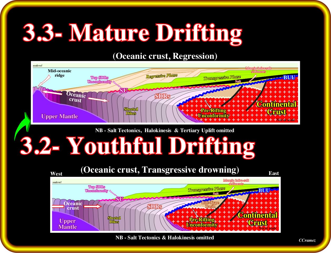
During the drifting regressive phase (± 60-0 Ma), the eustatic fall of sea level during the Tertiary was enhanced by epeirogenic uplift of continental crust. Each South Atlantic margin widened by progradation of a regressive wedge. On seismic lines, this regressive phase is separated from the underneath transgressive phase by a major downlap surface. Continental facies shifted seaward and the coastal break merged with the shelf break. The regressive wedge thickened seaward, then tapered into deep water. Epeirogenic local uplifts of several kilometres were created within the continents by intraplate stress, underlying igneous activity or unknown reasons. Uplifts locally steepened the continental margins, and bevelled major angular unconformities across them in the mid-Tertiary. The uplifts are easy recognized on the seismic lines, particularly in offshore, where they are more significant (more than 1000 meters).
Summing up :
(i) Total's hypothesis, in which salt basins formed after the continents separated, follows Guiraud and Maurin, 1992 and Karner et al., 1999, for who the rifting ended before salt was deposited ;
(ii) The conjugate salt basins (Congo-Angola and Brazil) were always separate and independent ;
(iii) The Aptian salt demonstrably overlies the breakup unconformity (three dimensions plate-tectonic reconstructions are highly significant) ;
(iv) Wherever SDRs (subaerial lava flows) have been identified on both margins, they underlie the distal salt basin or its stratigraphic equivalent.
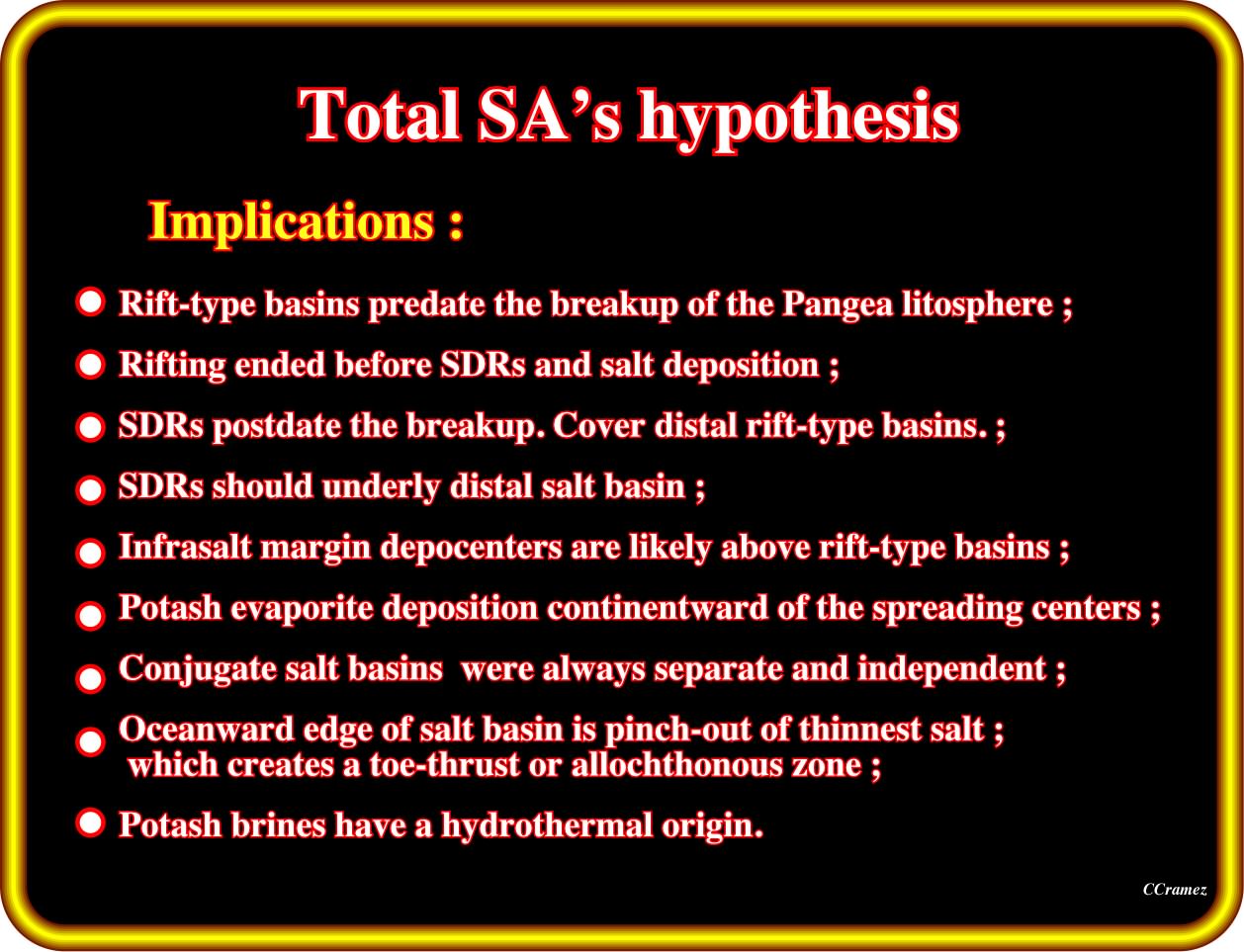
In relation to the old conventional models, in Total's hypothesis not only the subaerial lava flows (SDRs, i.e, seaward dipping reflectors) postdate the breakup of the Pangea lithosphere, but evaporites as well. The rift-type basins, developed during the lengthening of the Pangea lithosphere, are limited by the breakup unconformity and fossilized either by (i) margin infrasalt sediments (evaporites or basal sandstone) ; (ii) margin suprasalt sediments or (iii) SDRs (just for the more distal rift-type basins).
On seismic lines of Lower Congo Basin (Lehner and de Ruiter, 1977), South Gabon Basin (Meyers et al., 1996a), North Gabon and Douala basins (Meyers et al., 1996b), at the oceanward edge, thin undeformed autochthonous salt pinch out over oceanic or subaerial volcanic crust. However, elsewhere, on the African margin (Lower Congo, Kwanza, and Benguela basins), the autochthonous salt, under which seaward dipping reflectors, i.e., subaerial lava flows are evident, is tectonically thickened and is allochthonous along its leading edge, forming the Angolan Escarpment.
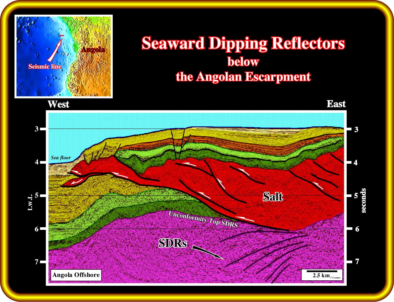
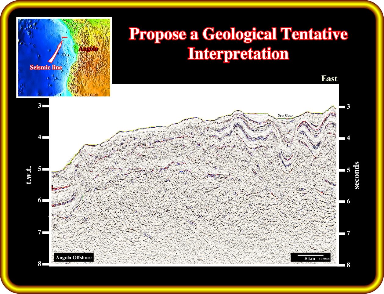
On this geological tentative interpretation of a seismic line of the Angola deep offshore, near the Angolan Escarpment, it is quite evident that, at least, in western border of the salt basin, the substratum of the salt corresponds to subaerial volcanism, i.e., corresponds to seaward dipping reflectors as geoscientists call such lava flows emplaced, immediately, after the breakup of the lithosphere (end of the lengthening of the lithosphere, during which the basins type-rift are developed). Here, in the distal part of the salt basin, the stratigraphic position of the subaerial lava flows is quite obvious : they predate the salt and postdate the lengthening of the lithosphere, that is to say, they postdate the rift-type basins. However, in the central part of the salt basin, often, it is much difficult to recognize if the volcanic material, drilled in certain exploration wells, postdates the breakup unconformity or if it predates the rifting, i.e., if it corresponds to a basement. Take into account that this seismic line is in time, the bottom of the salt, in the eastern part of the basin, is must deeper that the top of the SDRs in central and western part of the basin. In depth such a bottom salt morphology, which seems to correspond to the western edge of the salt basin, can be explained in different ways (see later).
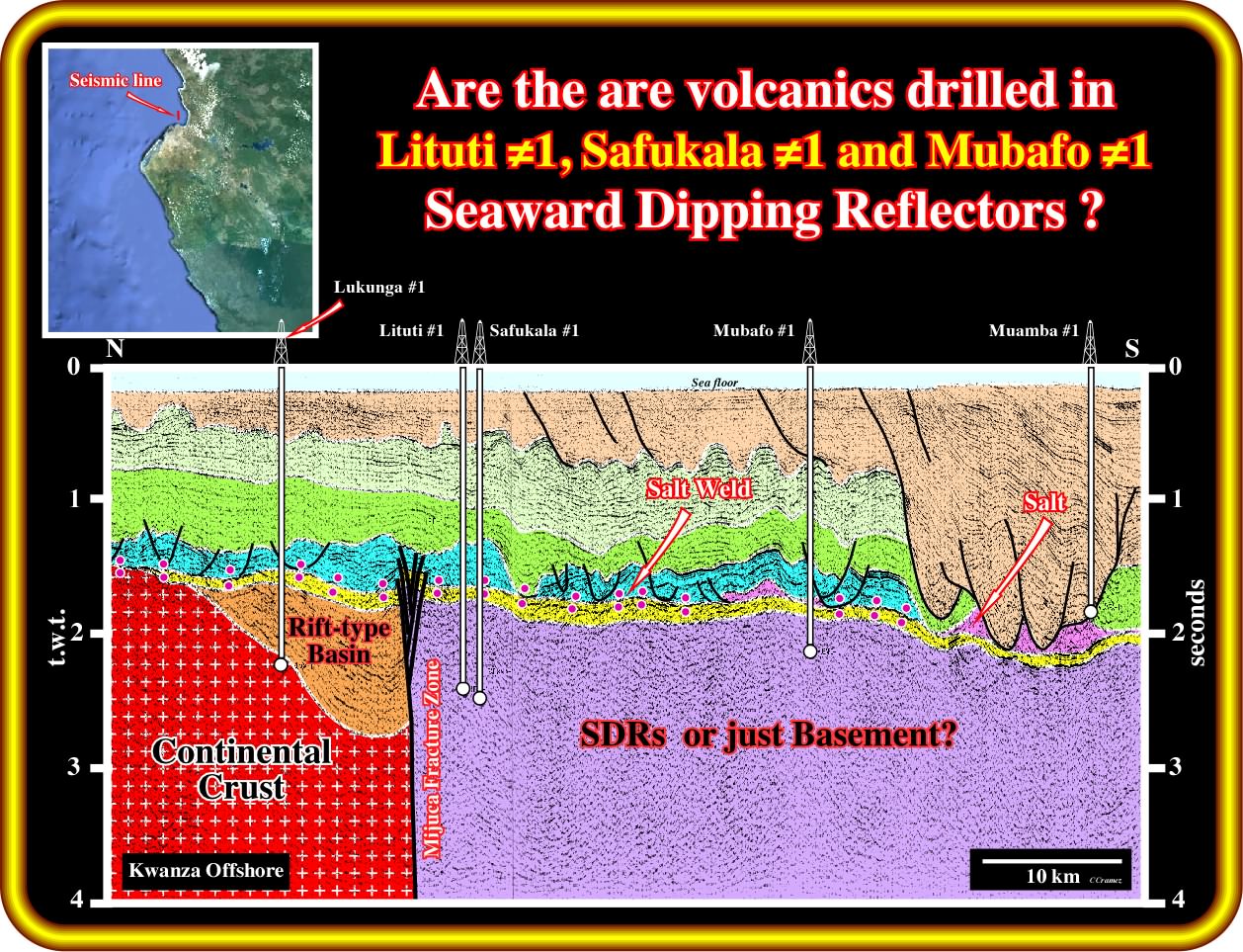
On this geological tentative interpretation of a seismic line of the Angola conventional offshore (water depth less than 200 meters), westward of a fracture zone striking NE-SW, the presence of a volcanic subaerial crust is, seismically, difficult to recognize (the seaward dipping reflectors are not visible), but the seismic line can be perpendicular to dip of the reflectors. Nevertheless, the results of wells Lituti ≠1, Safukala ≠1 and Mubafo ≠1 are conclusive, because they were stopped after drilling hundreds of meters volcanics (probably subaerial volcanism).
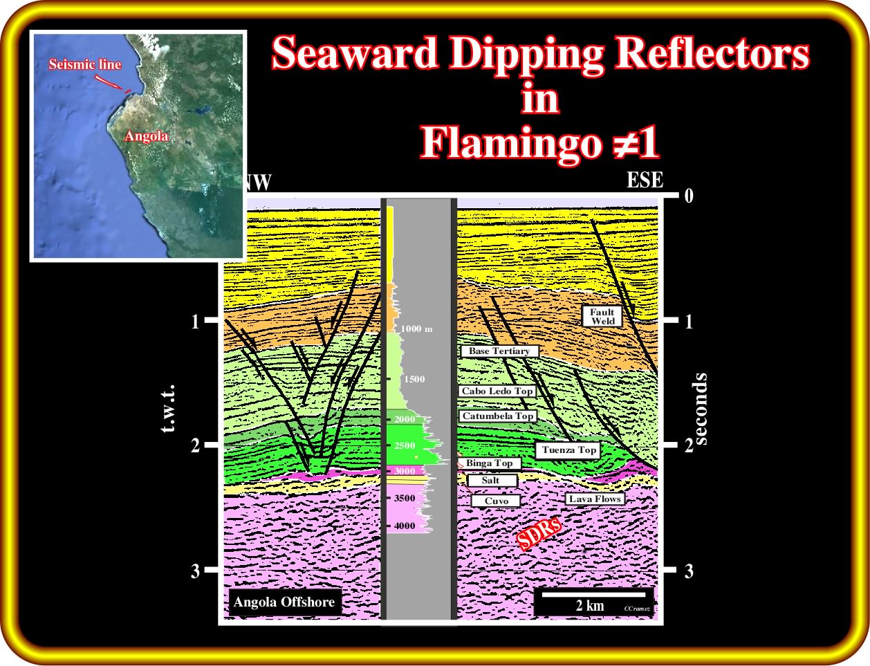
The Flamingo well, located in the Angola conventional offshore (block 6), not far from Luanda city (see next plate), drilled more the 500 meters of lava flow,. The seaward dipping reflectors are well visible on this seismic line, as well as in the HDT (dipmeter electric log). The geological results of this well are extremely important and must be taken into account in tentative geological interpretation of the seismic lines of the area, as illustrated in the next plate.
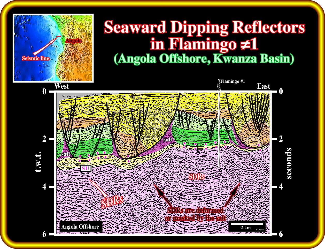
Without the results of the Flamingo well, drilled at around 1 km northward of this line, the large majority of the geoscientists would interpret the seismic markers below the infra-salt sediments (yellow interval in this tentative interpretation) as either margin infra-salt sediments (postdating the breakup) or as rift-type basin sediments, predating the breakup unconformity. Fortunately, the results of the well strongly suggest that such seismic markers correspond to subaerial lava flows, that is to say ,to SDRs. The geometry of the SDRs is reinforced when the pitfalls induced by the lateral change in velocity, induced by the salt, limestones and sand-shale depocenters, are taken into account. Consequently, the big and important question to evaluate the hydrocarbon potential of this area is to know if this the volcanism found in Flamingo well can be correlated with the volcanism drilled in Lituti ≠1, Safukala ≠1 and Mubafo ≠1 wells and if it is in continuity.
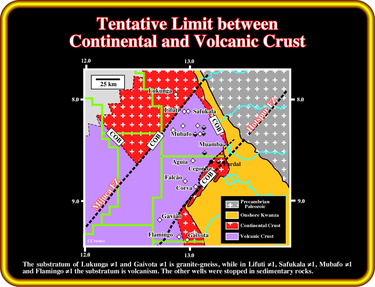
This plate illustrates a tentative mapping of the limit between the continental crust, which can be lengthened, and the volcanic crust (subaerial lava flows, i.e.,SDRs or oceanic), which postdate the lengthening of the continental crust or, in other words, between the continental crust above which rift-type basins are possible and the volcanic crust, above which rift-type basins are impossible. This map strongly suggest that the old Precambrian fracture zones (here the Mijuca and Hotspur fracture zones) control the subaerial and oceanic expansion (sheeted dykes and pillow-lavas), which started immediately after the breakup of the Gondwana supercontinent. It is quite obvious that the spatial distribution of the SDRs is affect by the movement of the fracture zones (similar to the movement of piano keys). Northward of the Hotspur fracture zone, the COB (Continent Oceanic Boundary) shows an apparent eastward displacement of more or less 50 km. Consequently, a seismic line crossing fracture zone can show an abnormal and abrupt change from continental to volcanic crust. Just dip seismic lines shot within the same geological province (area bounded by two consecutive fracture zones) show the really characteristics of the SDRs.
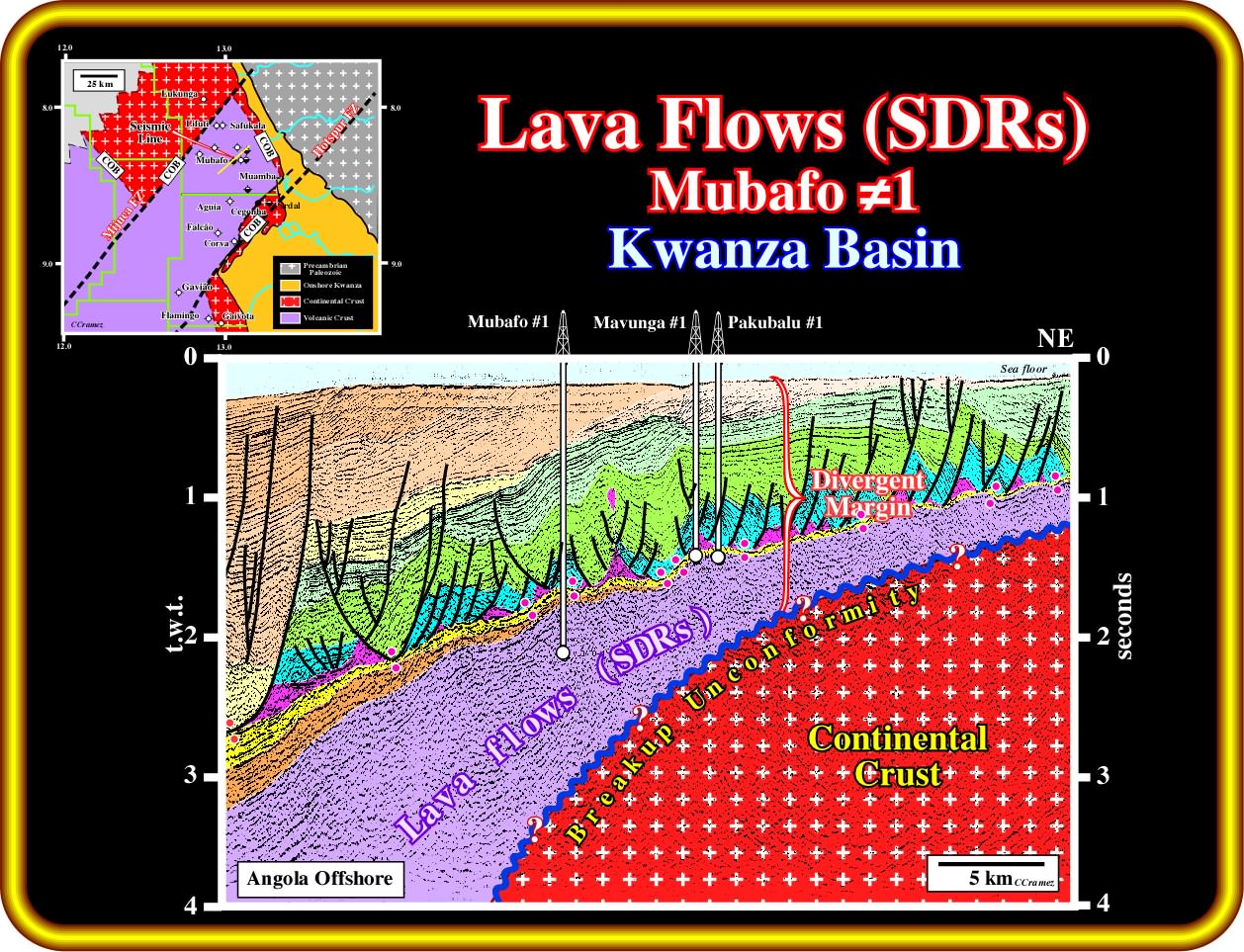
This tentative geological interpretation of the seismic line passing through Pakubalu ≠1, Mavunga ≠1 and Mubafo ≠1, is very instructive at different subjects. Firstly, the Mubafo ≠1 well recognized several hundred meters of volcanism and was stooped in it. Secondly, the seaward dipping reflectors are quite well visible, particularly in the lower western part of the line, what is quite naturally, since the orientation of the seismic line is parallel to the dip of the lava flows, what is not the case on the line passing through Lituti ≠1, Safukala ≠1 and Mubafo ≠1 wells (see three plates back). The position of the breakup unconformity is highly speculative ; it suggests, , just, that under SDRs postdating the breakup) rift-type basins and continental crust are are possibly.
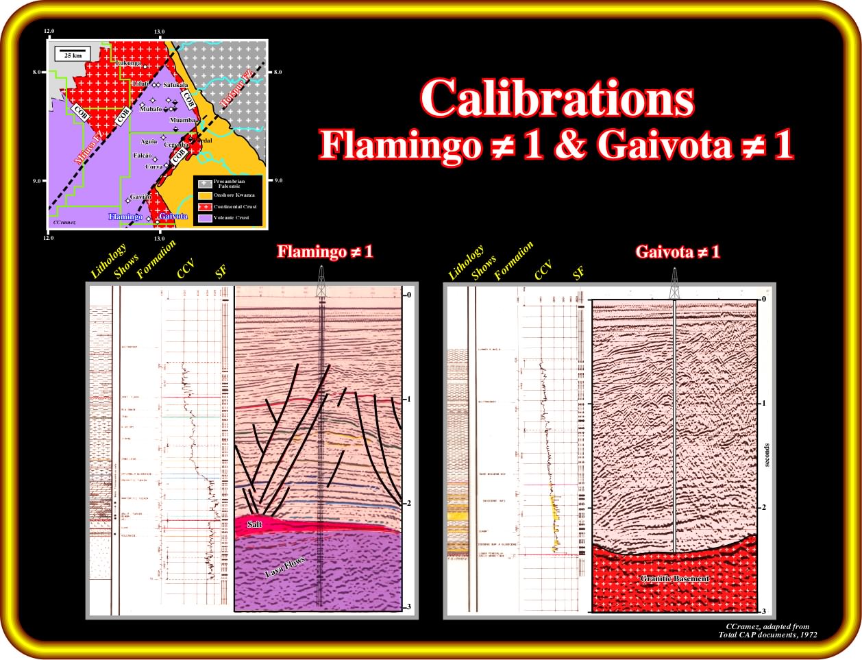
In spite of the fact that the distance between Famingo ≠1 and Gavião ≠1 is small (less than 10 kilo meters), the lithology of the infra-salt strata is completely different. Flamingo ≠1 recognized half a seconds of the volcanic material, quite probably subaerial lava flows dipping seaward, while the well Gavião ≠1 was stopped in granitic rocks (no massive salt or margin infra-salt sediments were found). Notice, the different seismic answer of the interface salt - volcanism, in Flamingo ≠1 and the penesaline sediments - granitic rocks, in Gaivota ≠1. Generally the term penesaline qualify an environment intermediate between normal marine and saline, characterised by evaporitic carbonates often interbedded with gypsum or anhydrite, and by a salinity high enough to be toxic to normal marine organisms.
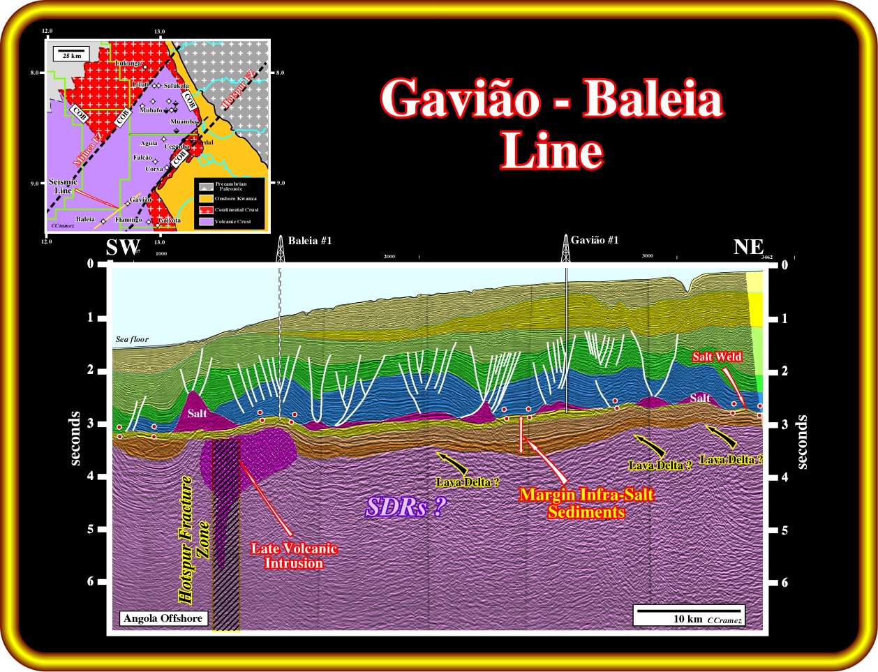
This geological tentative interpretation of seismic line passing through the Gavião and Baleia seems quite coherent, since it seems to fit with the crustal unities defined previously in the conventional offshore nearby Luanda city.. However, it should be notice that there is a big difference between a coherent and probable interpretation. Believing and knowing are quite a different matters. No interpretation can be pedantically termed axiomatic. Sub-aerial lava flows seem to be present below margin infra-salt sediments (having in Falcão ≠1 very good qualities of source-rocks). The top of the lava flows, which underlines the SU unconformity (top SDRs unconformity), which in Angola is almost 10 million years younger than the breakup unconformity, shows anomalies than can be interpreted as lava deltas looking continentward. Locally, the lava flows, as well as, the overlying margin infra-salt sediments were strongly deformed by a volcanic plug intrusion, emplaced along the Hotspur fracture zone, and later eroded, before the deposition of the uppermost margin infra-salt interval (in yellow in this tentative interpretation).
Admittedly, the above tentative of the COB position (continental oceanic boundary, see one before last plate), based on the assumption that the volcanism recognized in the exploration wells (Lituti ≠1, Safukala ≠1 and Mubafo ≠1 and Flamingo) corresponds to subaerial lava flows postdate the breakup unconformity, must be tested. The hypotheses that the volcanism predates the breakup unconformity, and particularly the lengthening of the Gondwana lithosphere (i.e., that it corresponds to the basement) must also be possible and so must be also tested. Such a refutation tests can be done by the tentative geological interpretations of seismic lines calibrated by the explorations wells, as illustrated in next chapter.
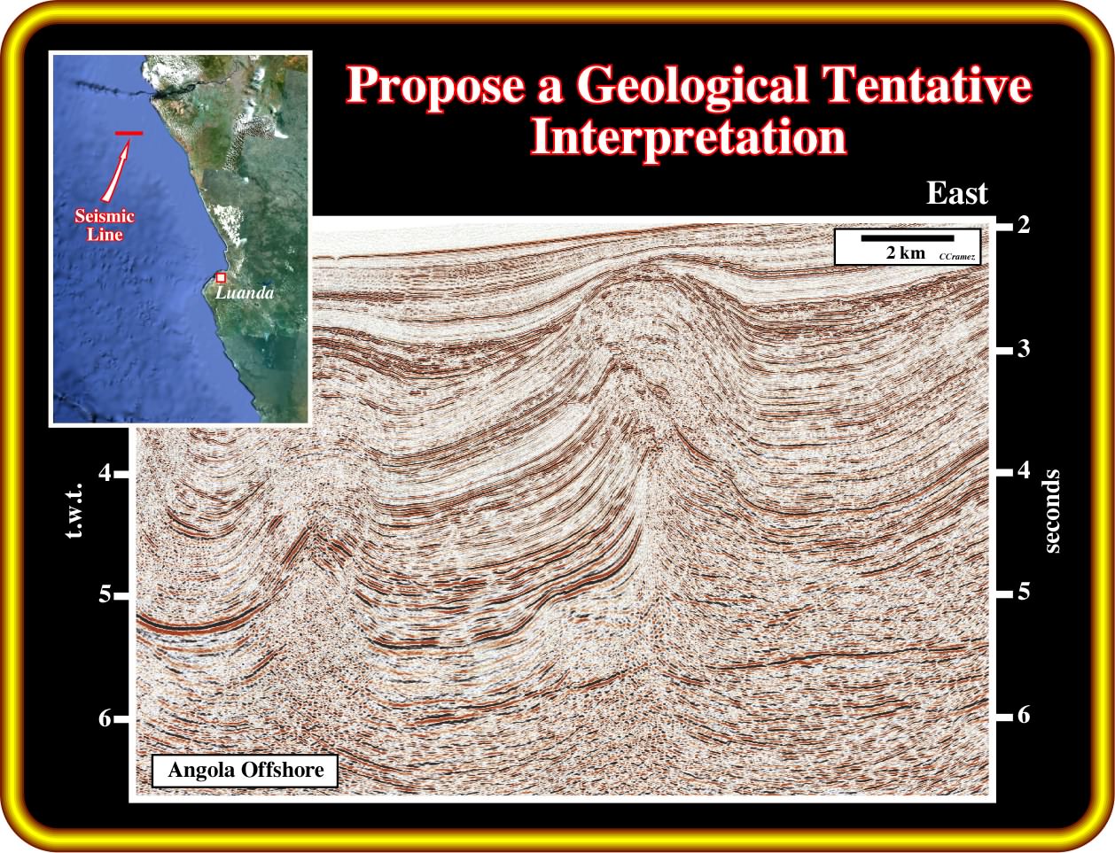
Exercise 1:
Focus your tentative interpretation in the picking of the salt (autochthonous and allochthonous) and infra-salt strata. Then, explain the origin of the folded-belt recognized in central and eastern part of the line. Finally, explain the formation of the Angolan escarpment.
Exercise 2:
Your tentative interpretation must be based on the picking of the salt and associated salt welds (primary, secondary or tertiary), as well as on the infra-salt strata. Propose the more likely stratigraphy of the infra-salt strata using the age of breakup unconformity as reference time. Explain the shortening of the salt and overburden,and the translation onlap surfaces that you must pick in your tentative interpretation.
to continue press
next