
3) Are there refutation tests of the COB mapping?
As said previously, geoscientists, must decide if the volcanism recognized in the explorations wells drilled in the conventional offshore of the Kwanza basin, near Luanda city, correspond to subaerial lava flows or to the basement (pre-breakup), since the implications in hydrocarbon exploration are quite important. In fact, if it corresponds to SDRs /seaward dipping reflectors), the probability of presence of rift-type basins below them is insignificant. and, in other hand, it can just be covered by margin infra-salt sediments, salt or supra-salt sediments. On the contrary, if the volcanism predates the lengthening of the Gondwana lithosphere, i.e., if it corresponds to a basement or an infrastructure, rift -type basins with organic rich lacustrine sediment, are likely above it.
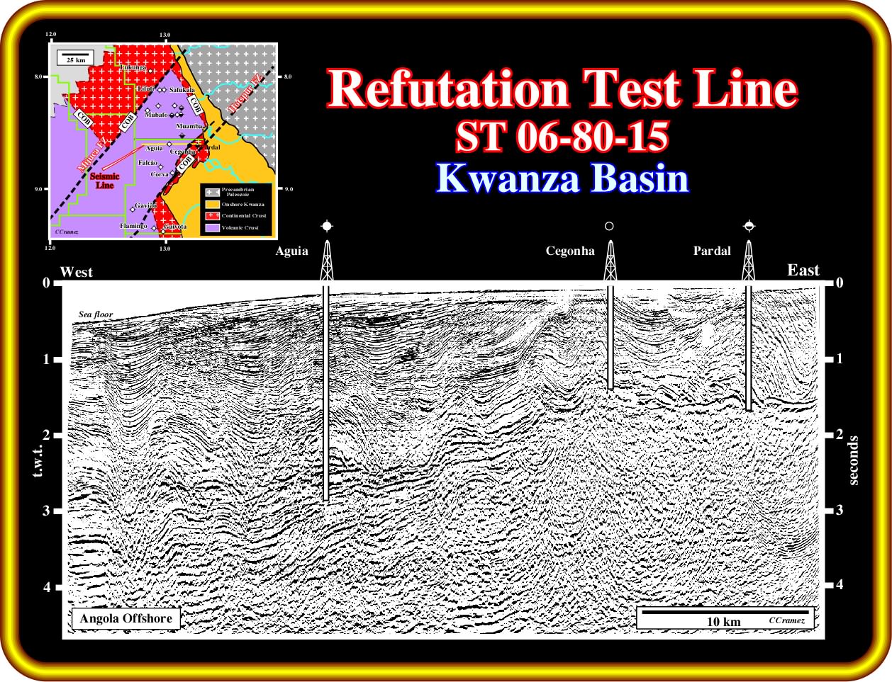
The geological tentative interpretation of this seismic line of the Kwanza offshore, located near the area where subaerial volcanism was found in several explorations wells, such as Lituti ≠1, Safukala ≠1, Mubafo ≠1 and Flaming ≠1 (see location in the upper left corner), as the interpretation of any other seismic line, is dependent of the knowledge and theory adopted by the interpreter geoscientist. In fact, contrary to the idea that observations in geology are the facts upon which scientific hypotheses are based, it must be said that the majority of geological hypotheses were and are formulated, a priori, in order to explain the problems raised by observations, that is to say, the hypothesis and conjectures are not built from a collection of detailed geological observations using an inductive approach. The major problem with these geoscientists is that they are afraid to make mistakes. To them, contrariwise to K. Popper (1934), observation precedes theory. They make descriptive observations (without an a priori geological model) and, then, they propose their own model to explain their observations. Then and contrarily to the geoscientists following an hypothetical-deductive approach, they look mainly to data that corroborate their model (verificationism, which historically, has been used to render meaningless, false, unscientific, or in some other way illegitimate many philosophical debates, due to their positing of unverifiable statements or concepts), because their mind filtrate (forget) t data refuting their model. In other words, an geoscientist make geological tentative interpretation of the seismic lines sees on them, just what he knows and what is looking for. On this subject, the next plate, is highly significative.
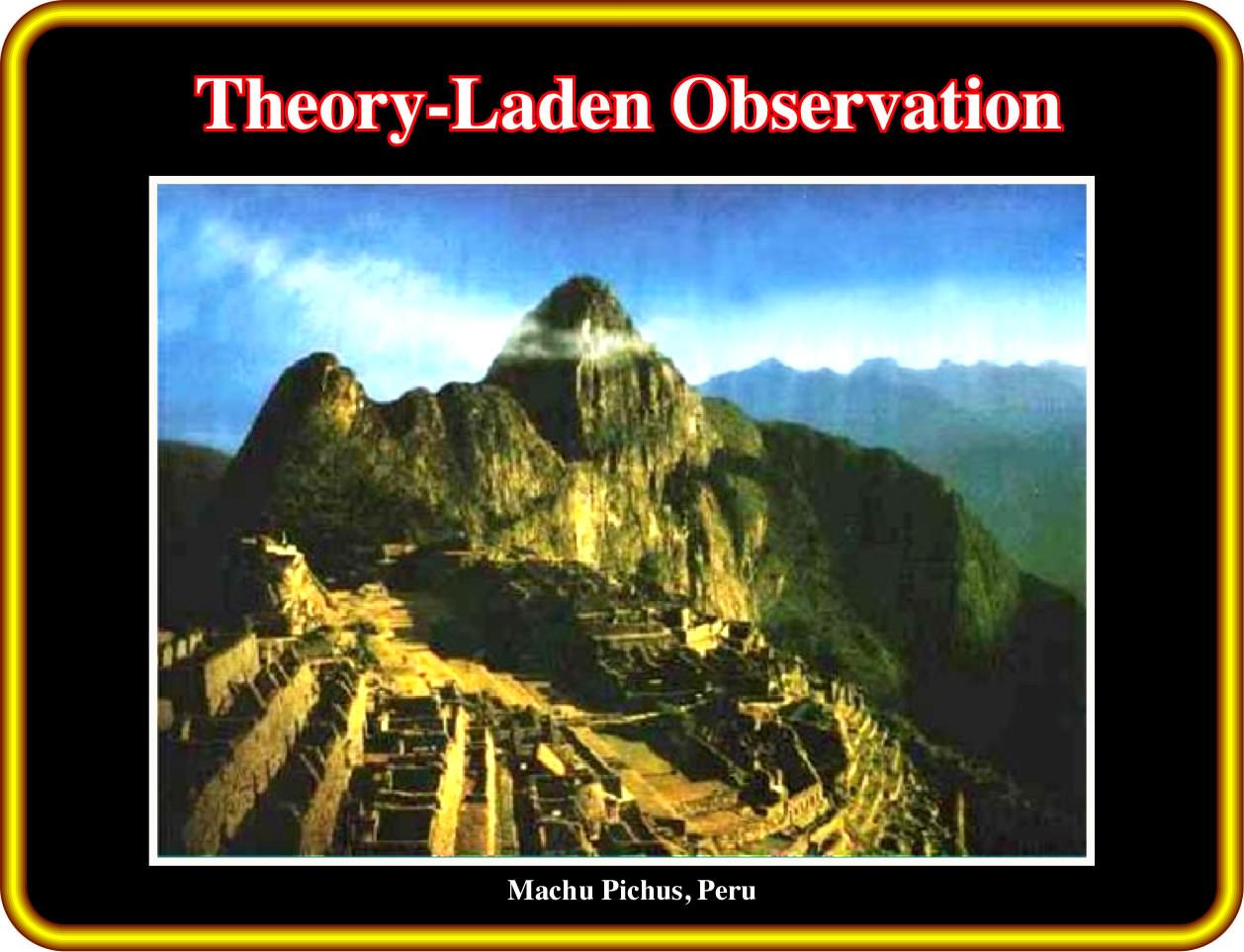
A seismic interpreter geoscientist sees on a seismic line just what he knows and what he expect to find on it, as a tourist, after visiting the Machu Pichus, in Peru, recognizes, in his souvenir-photos, as the one illustrated above, i.e., the beauty of the architecture of the old city. However, if you turn 90° to the right this photo, I'm sure that you see something different. In fact, one of the most appealing subject of Karl Popper's philosophy is the idea of theory-laden observation, that is to say, whenever you are making an observation-statement to question some theory, you are relying on some background theory which shapes your observation. Any observation, no matter how basic, is thus inherently theory-laden. You cannot simply speak of observation as true or fact since the background theory that shapes them can be false. In other words, each geologic theory or hypothesis is assisted by observations and observations controlled by theory. In geological interpretation of the seismic lines is the same thing, as illustrated next.
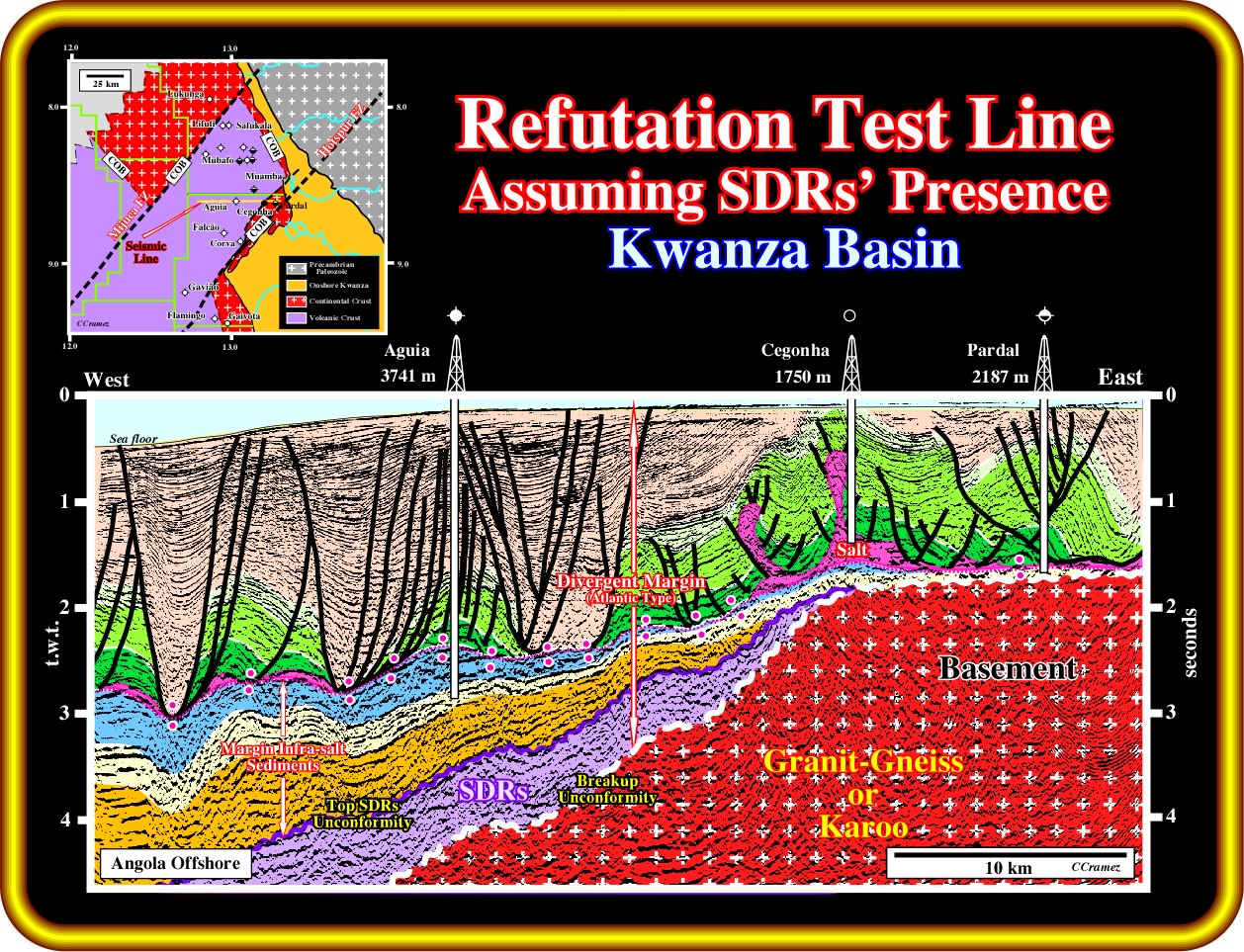
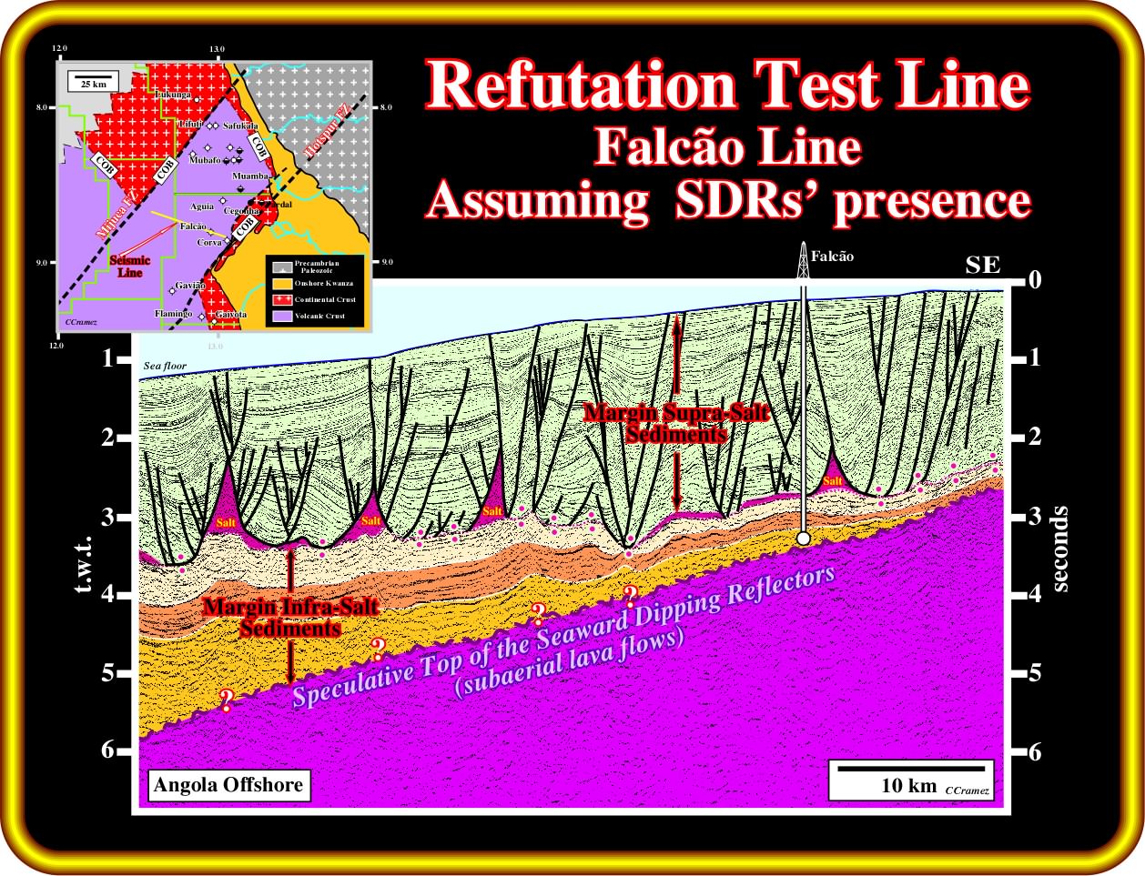
Admittedly, in this geological tentative interpretation, the interpreter geoscientist adopted the hypothesis that (i) subaerial lava flows postdate the breakup of the Gondwana lithosphere and (ii) rift-type basins, developed during the lengthening of the Gondwana, have a characteristic half-graben geometry with the bordering fault looking seaward and the infilling sediments dip continentward. On the hand hand, he assumed the presence of huge margin infra-salt depocenters ("sag basins" of the American geoscientists) above the subaerial volcanic strata and a lot of pitfalls induced by the lateral changes in thickness of the salt layer and supra-salt sediments. However, this seismic line, and particularly the infra-salt strata, can be interpreted completely differently, as illustrated next.
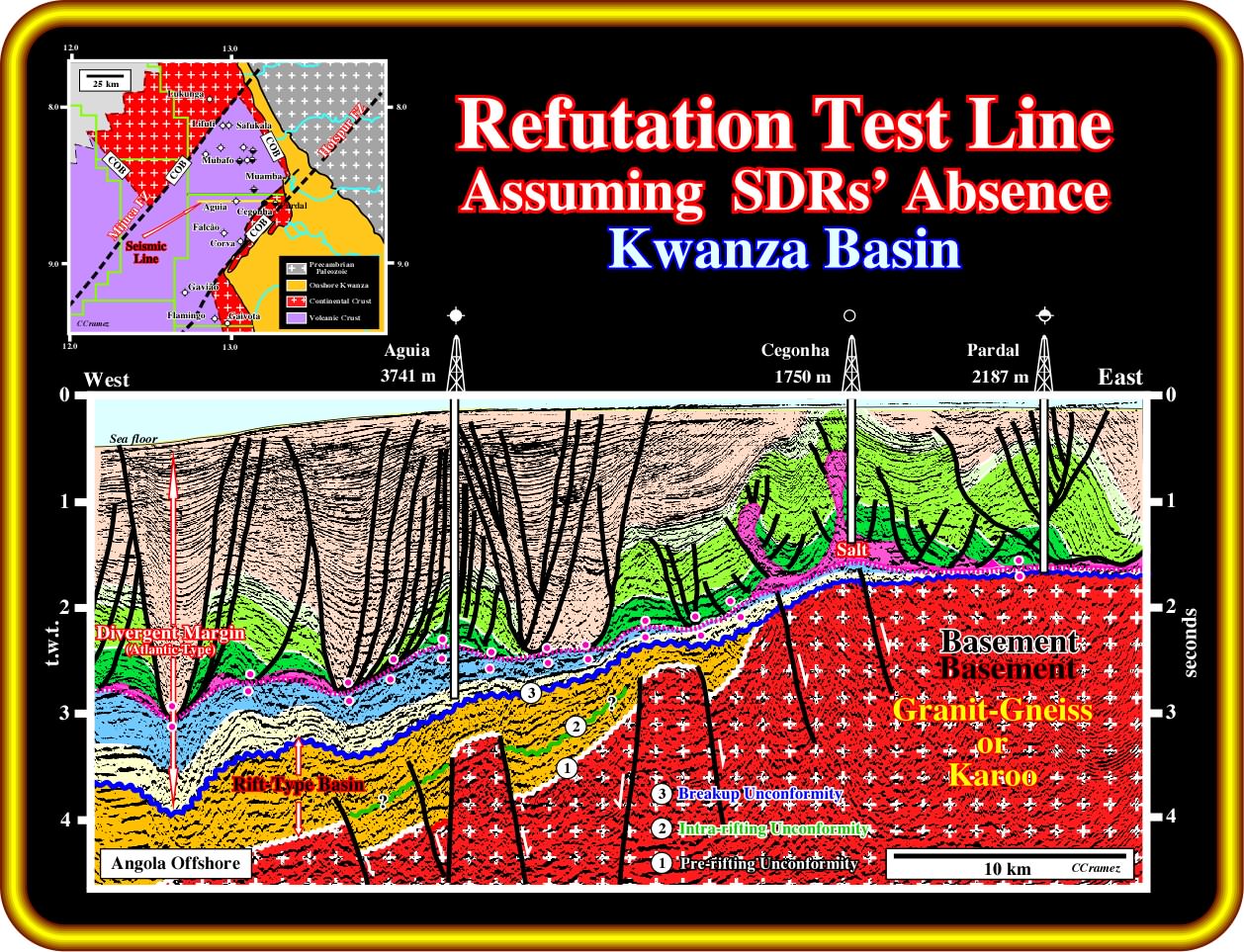
In this geological tentative interpretation, the interpreter geoscientist adopted the hypothesis that seaward dipping reflectors, i.e., subaerial lava flows, do not exist the central and proximal part of the Kwanza basin and that all volcanism found in the exploration wells predates the lengthening of the Gondwana lithosphere, i.e., it belongs to a substratum or a basement of the rift-type basins and margin sediments. Notwithstanding, we took all seismic pitfalls, induced by the lateral change of velocity within the margin sediments, as buried hills of the basement between the lower part of the rift-type basins. Finally, and contrariwise to an well known characteristics of the Kwanza and Congo rift-type basins, he assumed that the internal configuration of the rift-type sediments is divergent seaward. Concerning the hydrocarbon potential, this geological tentative interpretation is, apparently more favourable that the tentative illustrated in the previous plate (tentative assuming the presence of SDRs), because potential organic rich rift-type sediments are possible. However, it is interesting to notice that part of rift-type sediments of this no SDRs interpretation are in included in the margin infra-salt sediments of the interpretation assuming the presence of the SDRs, in which potential source-rocks are likely (they were drilled in Falcão ≠1 (block 6).
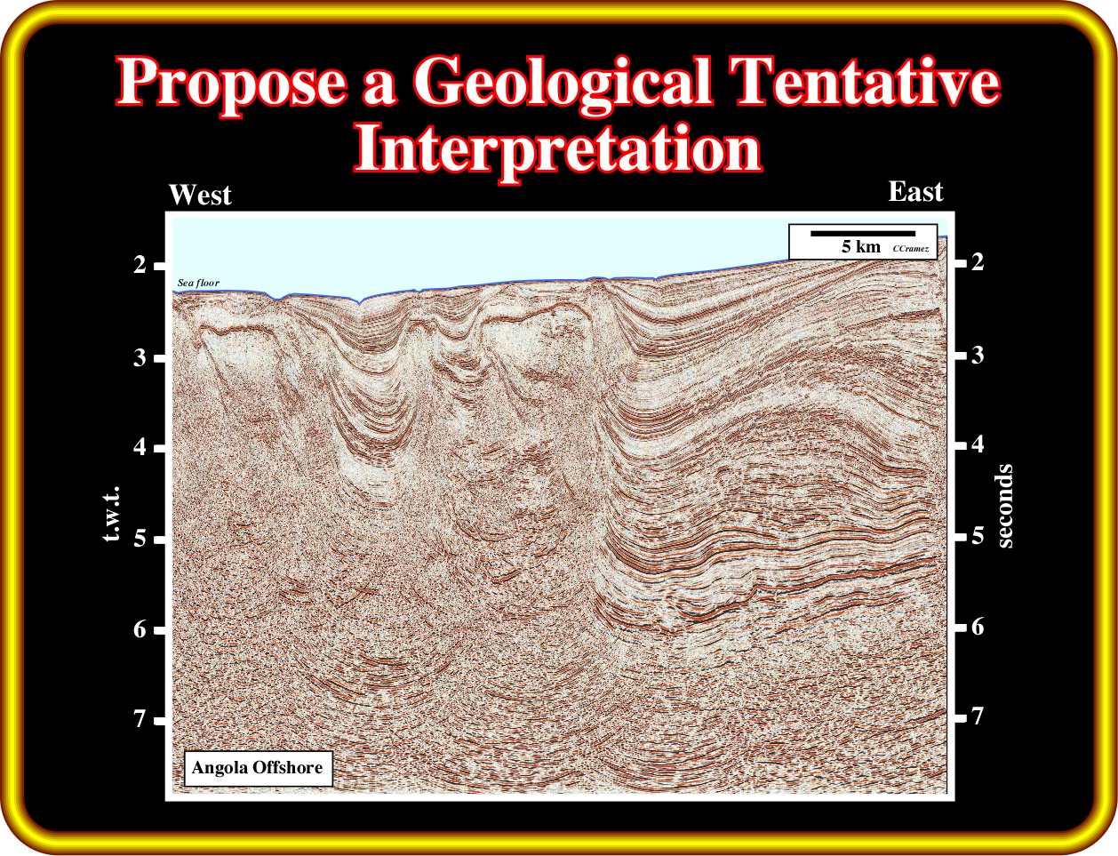
Exercise 1 :
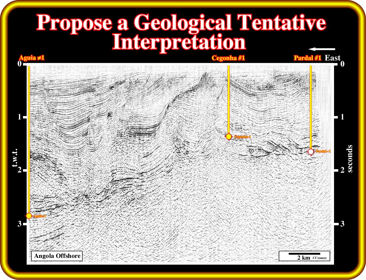
Propose a geological tentative interpretation of this seismic line, which is a reprocessed version of the previous line. Taking into account the regional geological context of the area (see location of the nearby wells in the COB mapping illustrated in the previous plate) without forget that the best tentative interpretation is the one more difficult to refute, in other words, criticise your interpretation.
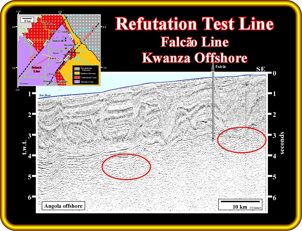
Falcão ≠1 well was located on this seismic line, apparently, to test a supra-salt turtle back structure, and probably to recognize the stratigraphy and generating hydrocarbon potential of the infra-salt strata (general term including of rocks below the salt, i.e., margin infra-salt sediments, SDRs, rift-type basin sediments or basement). As usually, any hydrocarbon accumulation was found within the turtle back, but the well recognized organic rich shaleprone interval with a good generating hydrocarbon potential in the margin infra-salt sediments. The more likely geological tentative interpretation of the line is illustrate on the next plate. Take note, that so far, in Kwanza basin, that is to say, southward of Ambriz arch, just North Quenguela, in Kwanza onshore, found an economical hydrocarbon accumulation (± 40 Mbbl recoverable). However, the petroleum system is quite quite particular (Paleocene- Miocene), since the source-rocks, located in the core of the turtle-back structure, are Paleocene shales.
The results of the Falcão well corroborate the margin infra-salt sediments, in which the brown interval corresponds to organic rich shale. Such an interval can be considered as source-rock interval since the organic matter of the sediments is mature (take into account the Late Tertiary uplift of the continent and surrounding sedimentary basins). The proposed top of the subaerial lava flows is hypothetical. There is not a clearly seismic evidence of seaward dipping reflectors. The reflectors dipping seaward, visible below the infra-salt sediments in the central and eastern part of the line (see the clean section in the previous plate) are not too convincing, but we never know.
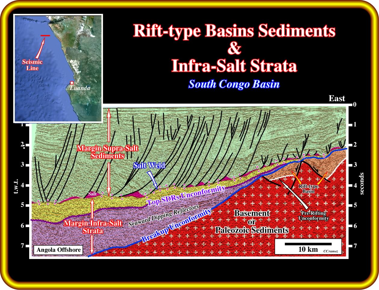
In this geological tentative interpretation of a seismic line of the South Congo Basin, the breakup unconformity is easily recognized at the top of the rift-type basins, developed during the lengthening of the Gondwana lithosphere, which, in this area, is composed by Precambrian granite-gneiss or metamorphic Paleozoic sediments. Above the breakup unconformity, margin infra-salt strata, dipping and thickening slightly seaward, are quite evident. In this tentative, the interpreter geoscientist considered that the lower part of the margin infra-salt strata is composed by seaward dipping reflectors, that is to say, subaerial lava flows and than an unconformity limits the seaward dipping reflectors for the overlying margin infra-salt sand-shale interval. Such a tentative, as all other tentative interpretations, must be tested, because the lower margin volcanic infra-salt strata can be, also, interpreted as a sand-shale interval with generating petroleum petroleum. The chosen geological tentative interpretation must be more difficult to refute and the one which match better with the regional geological setting. In case of equality, the geoscientist must adopt a pragmatic position, that is to say, chose the interpretation more favourable to the hydrocarbon exploration.
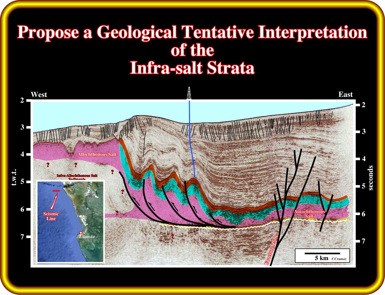
Exercise 2 :
After picking the salt and associated salt welds, concentrate your tentative interpretation in the infra-salt strata proposing the more likely stratigraphy and the more likely generating petroleum sub-systems. Explain the formation of the antiform structure visible on the right part of the line. Finally, how do you explain the uppermost depocenter (mini basin) on the left part of the line.
Exercise 3 :
Taking into account the occurrence of a major fracture zone in the left part of the line, explain the deformation of the supra-salt sediments. Then, propose different geological tentative interpretations of the infra-salt strata. How do you interpret the unconformity picked in white colour ? Justify your answers.
to continue press
next
![]()