
4- Are SDRs corroborated by the salt composition?
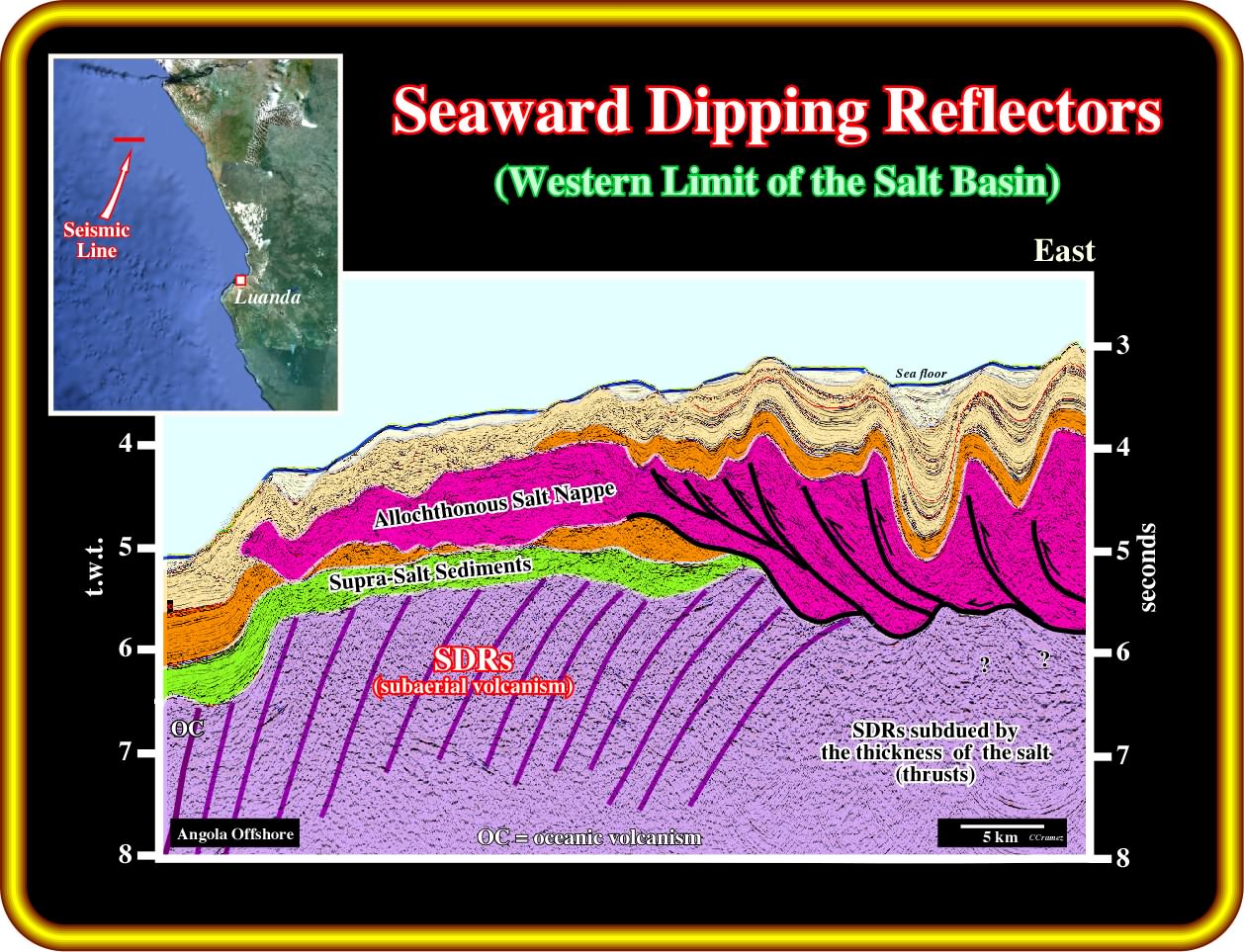
On this geological tentative interpretation of a seismic line of the Angola deep offshore, it is quite evident that, at least, in western border of the salt basin, the substratum of the salt corresponds to subaerial volcanism emplaced immediately after the breakup of the lithosphere (end of the lengthening of the lithosphere, during which the basins type-rift are developed). These lava flows are known as seaward dipping reflectors, since, generally, they dip toward the submerged spreading centres (volcanos) and thin toward the continent. Notice that during the continentward flowage of the volcanic material, lava deltas (with a sharp progradational geometry) can develop whenever they enter an epicontinental water body. As depicted above (take into account that this seismic line being in time, the bottom of the salt, in the eastern part of line, is must deeper that the top of the SDRs in central and western part of the line) autochthonous salt deposited immediately above the subaerial volcanic material (there is not evidence of margin infra-salt sediments on this seismic line). Such a feature, does not refute the hypothesis of an hydrothermal water-volcanism interaction to explain the potash evaporites rich in KCl and CaCl2 and poor in MgS04 found in Angola-Congo salt basin, located near the bottom of the divergent margin.
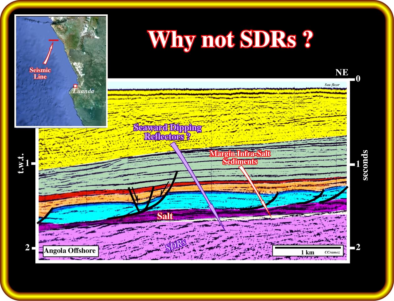
In this geological tentative interpretation of a seismic line from the conventional South Congo offshore (block 2), located not far from the Airoga well, the lower most seismic interval with a more or less parallel internal configuration, dipping seaward, can be better interpreted as subaerial lava flows rather than margin infra-salt sediments. In fact, assuming the second hypothesis, the dip and the upper unconformity are difficult to explain, because, generally, there is a seismic conformity between the margin infra-salt sediments and the bottom of the salt (or tectonic disharmony), except near the top of the buried hills of the basement. However, one cannot exclude that such westward dipping reflectors correspond to sedimentary interfaces of Paleozoic fold belt, which is considered as petroleum basement. Nevertheless, the consistency of the seaward dipping of these reflectors is more favourable to a subaerial lava flows interpretation than to a folded belt sediments (in this offshore, there is just one or two lines, in which, locally, the reflectors dip eastward). In Kwanza onshore, en particularly, in the Cabo Ledo area, the lava flows seem to dip and thinning continentward.

Already in the 60's, subaerial lava flows were found in few exploration wells drilled by Petrangol (Petrofina), particularly around the Cabo Ledo area (Tobias, Tombo, Puaça wells). It is interesting to point out that gas was produced in the lava flows and cinerites (sedimentary rock composed mostly of volcanic ash) in Puaça wells. In the original geological cross-section proposed by Brognon and Verrier (1964), the volcanism was mainly locate in the Tobias area and interpreted as a kind of volcano, which topography counteracted the westward salt gliding shortening. In fact, reverse faults and anticline structures developed in the salt and supra-salt sediments (as Tobias anticline illustrated in this plate). Fifty year later, the large majority of the geoscientists, working the in Atlantic offshore, know that : (i) Atlantic margins are for the most part volcanic ; (ii) Seaward dipping reflectors area paramount in central and distal part of the margin (where the spreading centres submerge due to the successive loading of the younger lava flows ) ; (iii) Subaerial lava flows thin away from the subaerial spreading centres, that is to say, they thin continentward ; (iv) Lava flows dip or can dip continentward near the landward border of the margin ; (v) Lava deltas with significant slopes are likely wherever subaerial lava flows of lava enter standing bodies of water (lakes or epicontinental sea). Taking into account, all this, it is plausible to interpreted the extrusive volcanic anomaly of Brognon and Verrier, as a lava delta, which implies a, more or less, standing water body between the area of Tobias and the eastern border of the margin. The presence of such a water body (probably in connection with the proto-ocean) is absolutely necessary to develop the salt brine. Such hypothetical interpretation can be tested by the new seismic lines shot by Sonangol in Kwanza onshore, particularly those passing through Tobias and Tombo structures. They must show between the tectonic disharmony and the margin infra-salt sediments reflectors dipping (significantly) landward with one or several small topographic anomalies (lava deltas) that inexperienced geoscientists are going, probably, interpreted them as rift-type basins and faults. In any case the concomitance between volcanic material and overlying water seems obvious, and so an hydrothermal water-volcanic material interaction is possible.
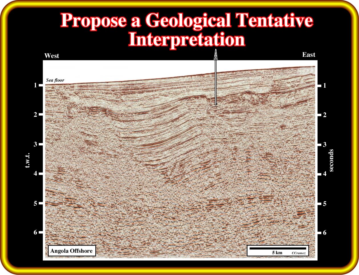
Exercise 1 :
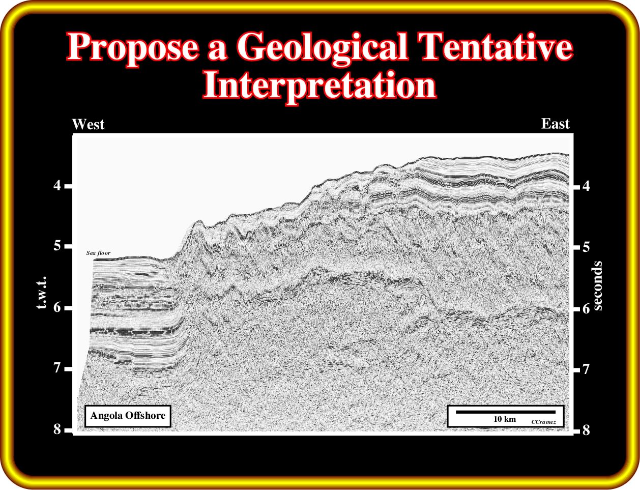
In yours geological tentative interpretation give a particular attention to the limits of the salt (allochthonous and autochthonous) and to the top of the infra-salt strata, since, as said above, it looks that there is a spatial, temporal and genetical relationship between the infra-salt rocks and the salt. Do not forget that this seismic line is in time, so to get an approximative depth picture of the bottom of the salt interval doubling the salt thickness. Explain how the folded belt visible on the overburden was created.
Exercise 2 :
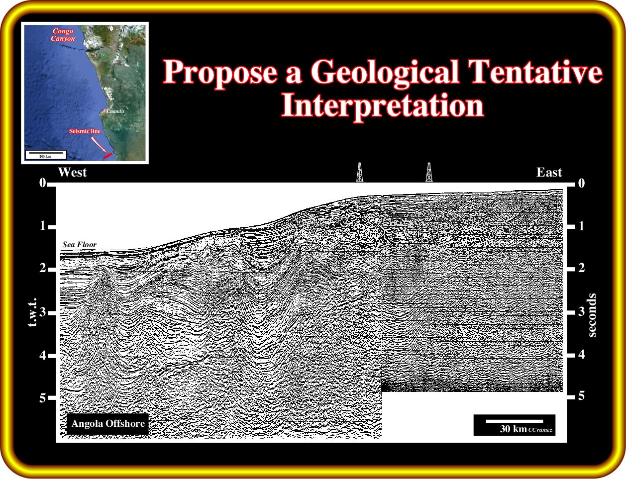
Focus your tentative interpretation in the bottom of the salt and associated salt welds (primary and secondary). Indivudualise the first order and second order rafts proposing the more likely facies (lithology). Characterize the internal configuration of the sedimentary intervals forming the post-salt depocenters and propose a facies interpretation. Then, you must try to interpret the infra-salt strata proposing the more likely lithology and unconformities (take into account the possible lateral change in velocity in the margin sediments).
As the seismic linr of the exercise 1 is particularly interesting to understanding the geochemistry and mineralogy of the evaporites, which fore the majority of the geoscientists is supplied by the subaerial lavas flows, find in next plate an esoteric geological tentative interpretation.
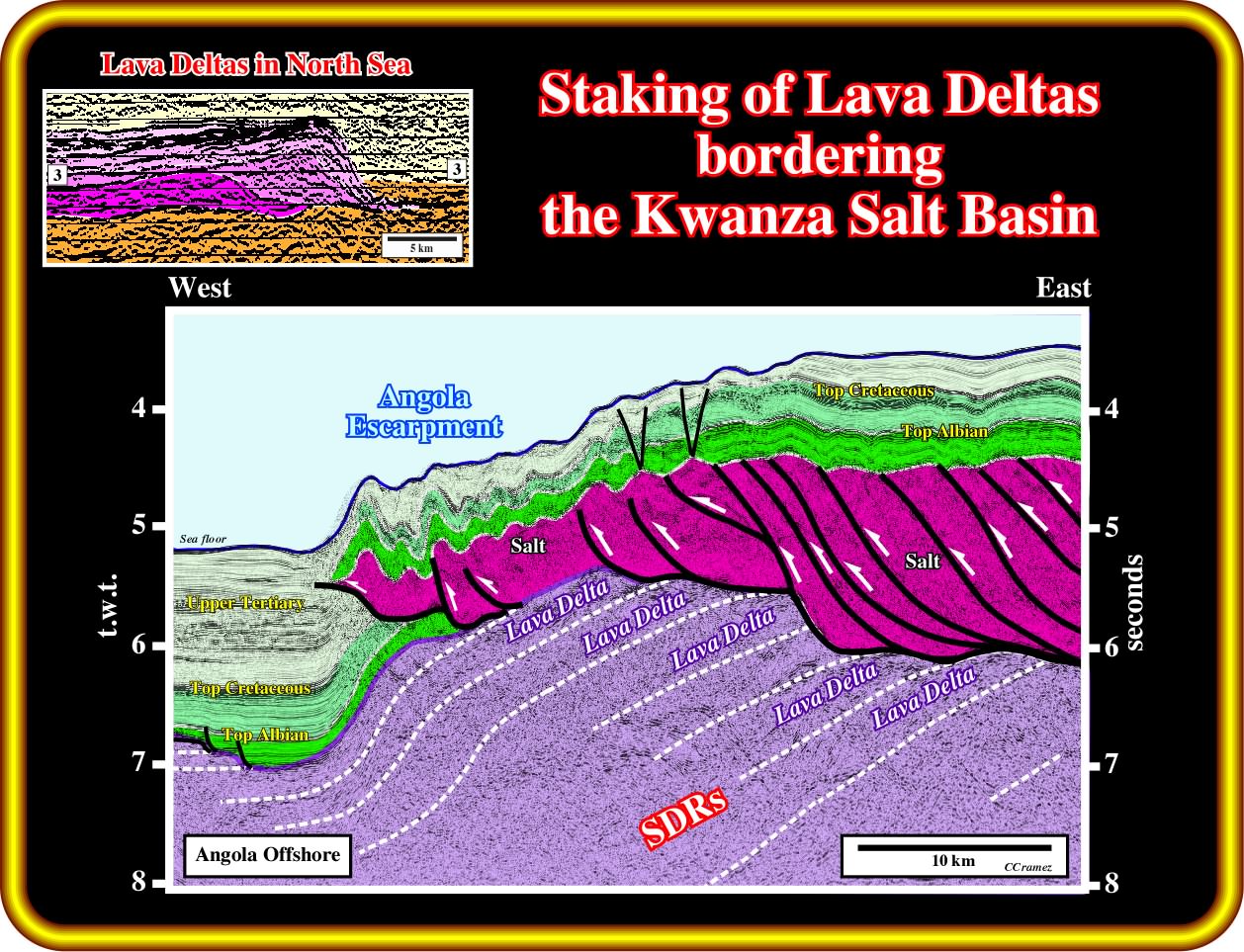
As illustrated on this geological tentative interpretation of the seismic line of the above exercise 1, the salt (autochthonous and allochthonous) was, clearly, thickened and thrusting, probably as an answer to the updip extension. The infra-salt strata, which form the western edge of the autochthonous salt basin, can be interpreted as a staking of the lava deltas. In fact, wherever sub-aerial lava flows enter standing bodies of water (lakes or proto oceans), the lava cools and breaks up as it encounters the water. Lava delta systems are known in association with formation of volcanic passive margins, where massive eruptions occurred along the eventual line of break-up. This volcanism led to the formation of extensive lava escarpments, interpreted as deltas, as its the case the Faeroes onto the Møre Margin (the Faeroe-Shetland escarpment) and the Vøring escarpment on the Vøring margin (see seismic line on upper left corner of this plate). When these deltas prograde into water of relatively constant depth, they can extend more than 50 kilometres from their original spreading centres.
Halite deposits, i.e., salt can form by evaporation of either seawater (an abundant source but critically dependent on sea level) or hydrothermal water (possibly less abundant but largely independent of sea level). The geochemistry of rock salt is rarely diagnostic to distinguish between these two brine sources. However, potash evaporites are much more diagnostic of their brine source. They form two groups:
a ) A rarer group rich in MgSO4 forms by evaporation of seawater originating from rivers. The sulphate minerals, polyhalite, kainite, and kieserite, are diagnostic. This group formed in the Vendian, Late Mississippian to Permian, and Miocene to Quaternary.
b ) The second, more common group is rich in KCl and CaCl2 and poor in MgSO4. This group cannot form by evaporation of seawater from rivers alone. The chloride minerals, sylvite, carnallite, tachyhydrite, and bischofite are diagnostic. This group formed in the Cambrian through Early Mississippian and Jurassic through Paleogene. CaCl2 brines that concentrate to form KCl minerals originate from brines enriched in CaCl2 by hydrothermal water-rock interaction.
The most suitable host, to form brines rich in KCl and CaCl2 and poor in MgS04, is basalt altered to spilitic greenstone. Albitization releases Ca into the brine, and chloritization absorbs Mg from the brine. As the brine wells up hydrothermally, the abundant Ca combines with any SO4 present to precipitate gypsum at the surface. The brine in lakes remains enriched in Ca. This could be the the situation during the Aptian time is not only in the Congo Basin, but Kwanza basin as well, as illustrated in the next plate.
These geological schematic cross-sections of the Congo and Kwanza basins, at the Aptian time ( more or less, 112 Ma), depict potential situations favouring the formation of KCl minerals originate from brines enriched in CaCl2 by hydrothermal water-SDRs interaction. In fact, the salt deposited in the in Angola Congo, Brazil, Gulf of Mexico, Virginia, New Jersey and, probably, in Nova Scotia margins has a particular composition (CaCl2-rich brines are typically enriched in base metals because it contains roughly 8 times more choride than sea water ; Pb-Zn-Cu mineralization was widespread during the Early to mid Cretaceous along S. Atlantic margins). KCl minerals do not prove that evaporites formed on basalt. However, the vast thickness, high temperatures and abundant plagioclase in flood basalts mean that these would have formed the most prolific source of Ca for the CaCl2. All known Aptian potash evaporites in the S. Atlantic formed from CaCl2 brines enriched by hydrothermal alteration: (i) The Sergipe-Alagoas basin contains carnalite and tachyhydrite tens of meters thick ; (ii) Aptian evaporites in Gabon contain carnallite-bischofite ; The Lower Congo Basin contains carnallite-sylvite with bischofite-tachyhydrite 150 m thick.
Other host rocks are also possible. Brine can interact with plagioclase-bearing arkoses or with Ca-smectites in redbeds. Limestones would also be a prolific source of Ca, but these are rare below the Aptian salts of the South Atlantic, which is not the case for sub-aerial volcanic rocks, as illustrated below.
The presence of tachyhydrite and similar chlorides does not prove the bedrock near the evaporites was basalt. The vast thickness, high temperatures, and abundant plagioclase in flood basalts mean that these will be the most prolific sources of Ca for the CaCl2. All of the known Aptian potash evaporites in the South Atlantic formed from CaCl2 brines enriched by hydrothermal alteration. The Sergipe-Alagoas Basin contains carnallite and tachyhydrite tens of meters thick. Aptian evaporites in Gabon contain carnallite-bischofite (Teisserenc and Villemin, 1989). The Lower Congo Basin contains carnallite-sylvite with bischofite-tachyhydrite 150 m thick. Moreover, Pb-Zn-Cu mineralization was widespread during the Early to mid Cretaceous along the South Atlantic margins. CaCl2-rich brine is typically enriched in base metals because it contains roughly eight times (8x) more chloride than seawater.
Clearly, the Aptian potash evaporites record hydrothermal interaction with a host rock that is probably basaltic. Such basalts could be the voluminous, rapidly emplaced SDRs, but these are not the only source. Spilitized basalts also form steadily at mid-ocean ridges. Alternation of KCl and MgSO4 types of potash evaporites has been linked to secular variation in seawater because of variations in sea-floor spreading rates (Hardie, 1996).
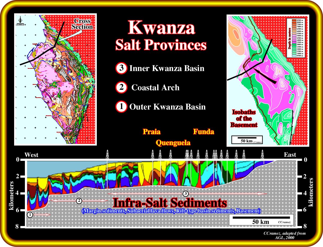
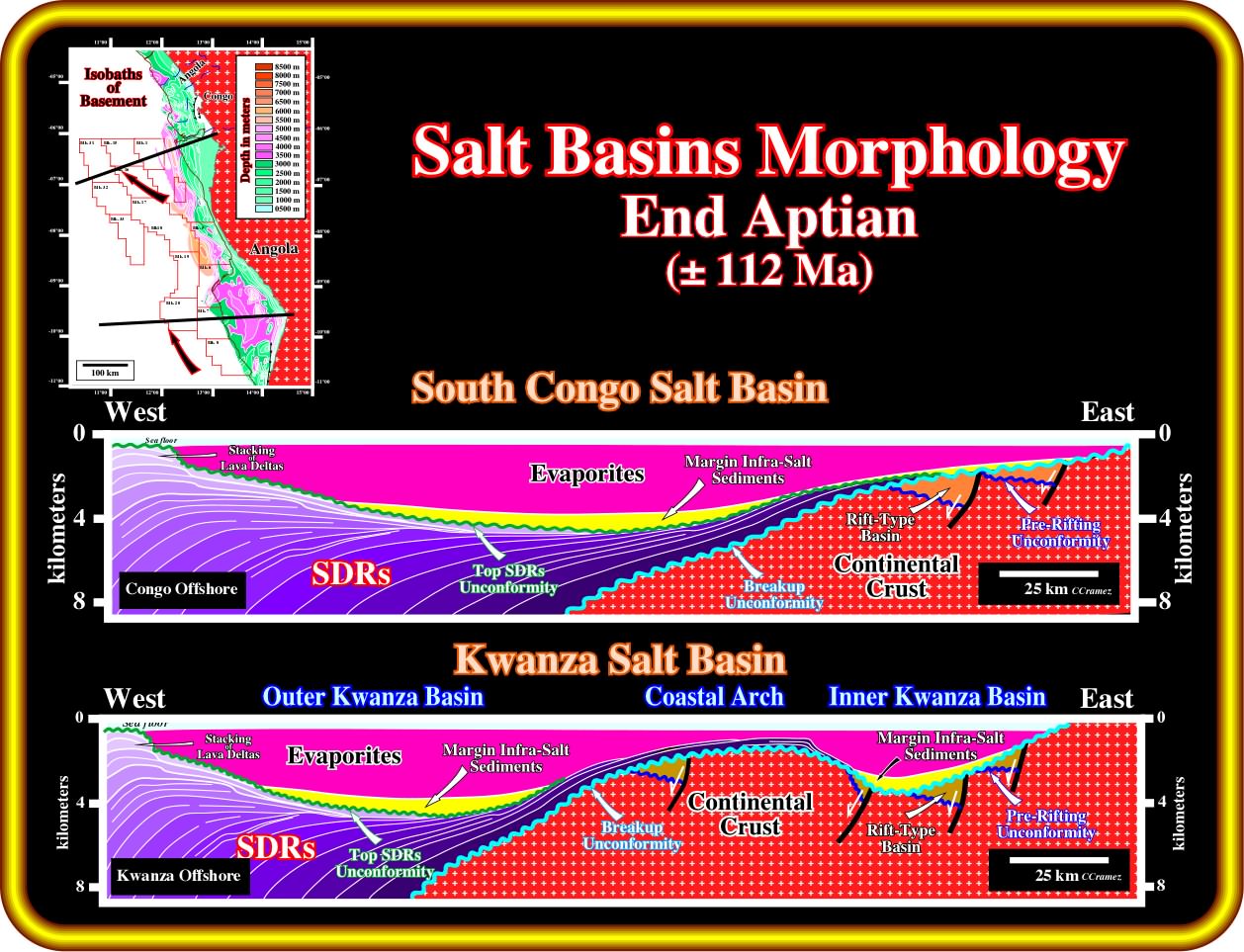
Geological restorations based on this cross-section, build upon on geological tentative interpretations of seismic lines through Kwanza onshore and offshore, as well as in the well's results, strongly suggest, at times of salt deposition (Aptian time), two large salt depocenters separated by a structural high of the infra-salt strata (margin infra-salt sediments, subaerial lava flows, rift-type sediments or basement), which define three salt provinces known often as : (i) Inner Kwanza basin ; (ii) Coastal Arch and (iii) Outer Kwanza basin. Taking into account the isobaths of the basement (map on the right corner of the plate), margin infra-salt sediments depocenters or rift-type basin sediments can be expected below the Inner and outer Kwanza salt provinces.
The Aptian had twice the modern spreading rate. Times of rapid spreading are marked by rise of sea level and sea-water temperature, changes in marine carbonate chemistry, and other greenhouse effects. Brines generated at mid-ocean ridges dominate those derived from river water, which ensures that hydrothermally derived KCl evaporites dominate. Thus, we cannot distinguish the setting (SDRs or mid-oceanic ridges) of the spilitized basalts that gave rise to KCl evaporites. However, the geochemistry is certainly compatible with Aptian evaporites accumulating over newly submerged flood basalts.
As the subaerial basalts subside, restricted circulation of inundating seawater can lead to the formation of evaporites directly on proto-oceanic basalts. It is important to notice that the COB, i.e., the Continental-Oceanic Boundary (the term oceanic should be replaced by volcanic, which includes the subaerial crust (SDRs) and t oceanic crust (sheeted dykes), is strongly affected by the fractures zones (see next plate), which partially control the oceanic expansion. In other words, the spatial distribution of the SDRs is much more complicated than that depicted in previous plate (End Aptian ± 112 Ma).
Perhaps the most vivid modern example of this is the Afar region of Djibouti in the Horn of Africa. Here, where the Ethiopian plume, the Red Sea rift, and the Aden spreading ridge all meet subaerially, evaporites are accumulating directly on proto-oceanic basalt crust. A prime example is the evaporites around Lake Assal, in the Afar region of Djibouti in the Horn of Africa (Manighetti et al., 1997). With these kinds of topographic dams, seawater periodically spills in and evaporates subaerially to form salt below sea level. These evaporites are coeval with proto-oceanic spreading. They form part of the post-rift package, whose accommodation space is provided by crustal thinning, cooling, magma withdrawal, and SDR wedges loading continental margins (Bens on, 1999).
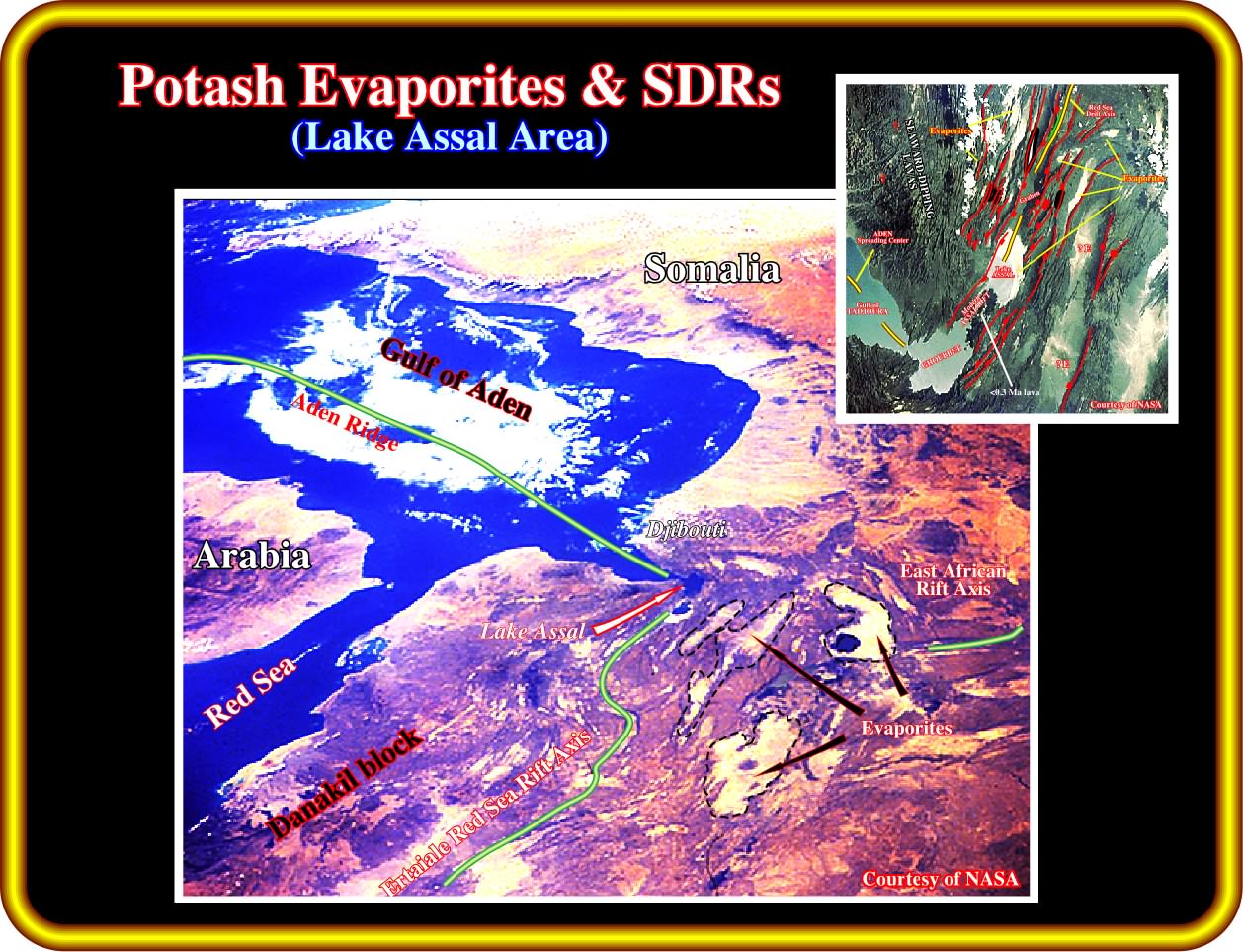
On of the best example of potash evaporite deposited from enriched brines, due to an hydrothermal water-volcanic material interaction, is in the Afar region of Djibouti in the Horn of Africa. As said previously, due to the volcanic (SDRs) topographic dams, seawater periodically spills in. The brines are enriched in potash by hydrothermal seawater-SDRs interaction and then evaporated subaerially to form salt below sea level. These evaporites are coeval with proto-oceanic spreading.
Are there modern analogues for subaerial mid-oceanic ridges ? Almost all present-day mid-oceanic ridges are submerged, but this is a feature of old, wide oceans. A fitter analogy would be the subaerial parts of mid-oceanic ridges currently thermally elevated by an underlying mantle plume, such as the Djibouti Afar on the Aden Ridge or Iceland on the Reykjanes Ridge. The Afar hot spot bulge allowed syn-rift Messinian evaporites to form throughout the Red Sea while open-marine conditions existed farther south in the Gulf of Aden (Crossley et al., 1992).
As in Afar, the Aptian salt basins were confined to the south by the subaerial swell of the proto Walvis Ridge and Rio Grande Rise. These ridges separated open-marine conditions in the south from restricted marine conditions in the north. In the northern parts of both the Walvis Basin and the conjugate Pelotas Basin, where volcanism was most abundant, the initial oceanic crust kept close to sea level or at a shallow depth until almost the Turonian (91 Ma, some 20 my after breakup; Abreu, 1998; Dingle, 1999). So it is likely that the mostly subaerial volcanic ridges acted as a dam. Gaps in the ridges would have allowed restricted access of seawater to the northern proto South Atlantic (Henry and Abreu, 1998). That would favour evaporitic conditions even after the oceanic crust had thermally subsided below sea level, as in the Messinian Mediterranean. However, simple evaporative drawdown would not suffice. In fact, assuming an average salt concentration of 3.5%, complete evaporation of the world’s oceans would yield a salt layer only 60 m thick (Borchert and Muir, 1964). The equivalent salt thickness for a single evaporative drawdown in the proto South Atlantic would probably be less than 20 m, given the average water depth of the present South Atlantic (± 4500 m) compared with the youthful depth typified by the modern Red Sea (± 1000 m). Because the Aptian salt thickness averages at least 1000 m, at least 50 cycles of complete filling and evaporation would be required in the 10 My available. Take into account that open-marine conditions were only established in the middle-upper Albian (Dingle, 1999).
Exercise 3 :
Give particular attention to the picking of the salt induced tectonic disharmony and to the stratigraphy of the infra-salt strata. Make a proposal for the possible location of the breakup unconformity. Finally explain the origin of the tectonic regime responsible for the faulting of the supra-salt sediments.
to continue press
next
![]()