
5 - Are there analogs for the Congo-Kwanza Salt Basin?
The answer is yes. In fact, particularly, in the Atlantic offshore, one can find places where, more or less, important evaporite layers were deposited at or near the bottom of the margins. In addition, the geochemistry and mineralogy of the evaporites strongly suggest that their brines were enriched by an hydrothermal water - subaerial lava flows or water- oceanic crust interaction. Let's show some significative seismic lines :
1) Brazil Offshore
1.1- Santos Offshore
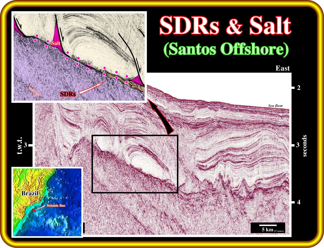
Northward of the Pelotas basin, in the Santos basin, where huge oil accumulation have been found in margin infra-salt sediments (sag basin of the Petrobras' geoscientists), seaward dipping reflectors are quite evident when the infra-salt margin interval is relatively thin and particularly under seismic resolution, as it is the case central part of this line (see close-up in the left top corner). Below the infra-salt margin sediments, that is to say, below the SU unconformity (top of the subaerial lava flows), the SDRs are quite obvious if you forbear the underlay multiple reflected seismic energy (event in seismic data that has incurred more than one reflection in its travel path). In spite of the fact that in this line the breakup unconformity is not visible, don't forget that theoretical and a priori, it is located at the base of the SDRs, since they postdate the breakup of the lithosphere.
1.2- Cabo Frio Offshore
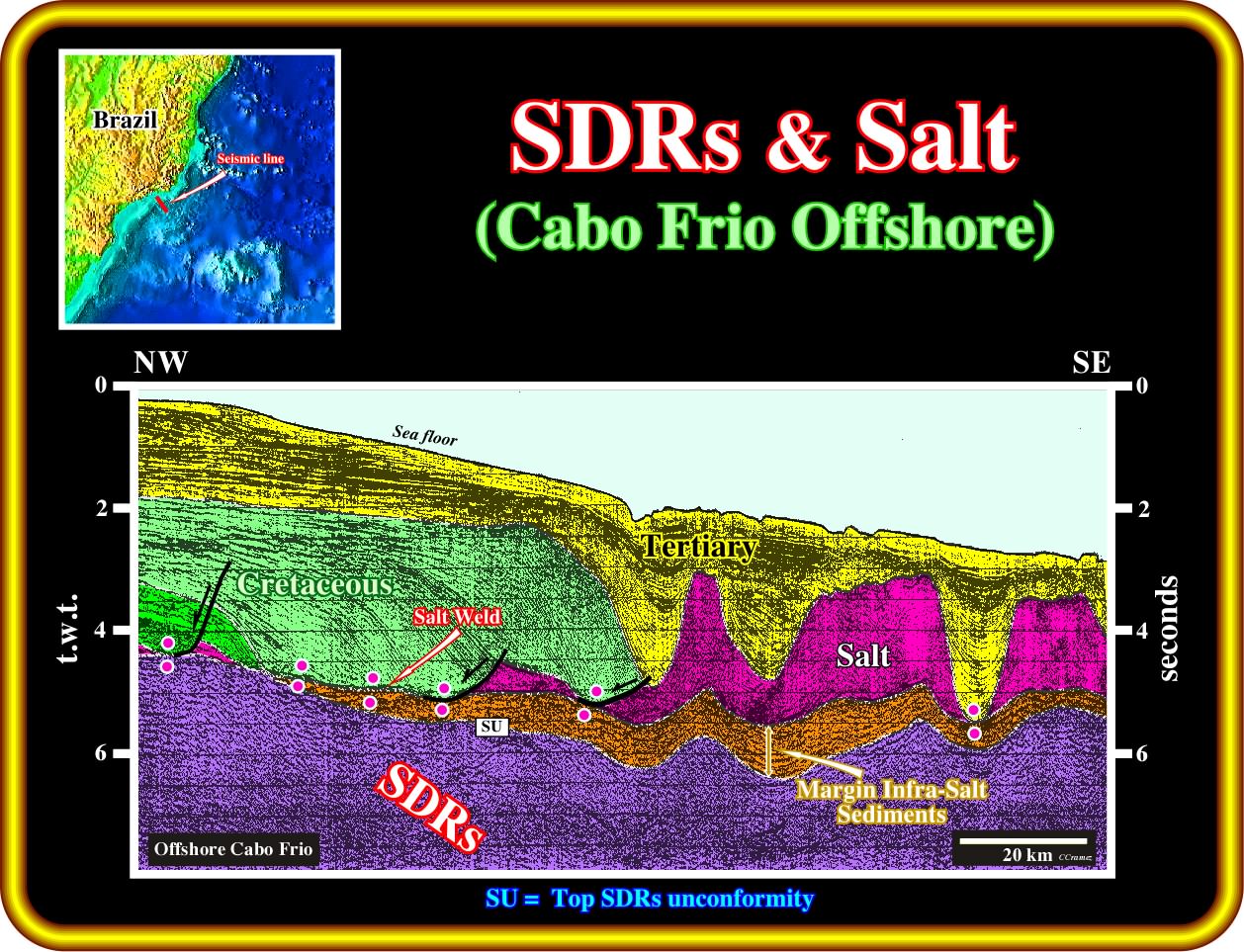
On this geological tentative interpretations, below the tectonic disharmony associated with the base of the evaporitic interval and associated salt welds, margin infra-salt sediments were recognized in the central and eastern part of the line. These sediments lie on SDRs (seaward dipping reflectors, i.e., subaerial lava flows), which top mark the SU unconformity. Pay attention to the fact that, there are not rift-type basins overlying SDRs. This corroborates the conjecture that SDRs postdate the breakup unconformity, which is located at the bottom of the subaerial volcanic crust. The tectonic disharmony is evident. It is locally represented by salt welds (absence of salt or a salt thickness lower that seismic resolution). The infra-salt margin sediments, which here are rich in organic matter (potential source-rock interval) are identified readily between the evaporitic interval (or a salt weld) and the SDRs. In the eastern part of this tentative interpretation, there presence of Tertiary depocenters and sharp variation on salt's thickness induce, in the underlying intervals, an apparent wavy geometry, which, locally, mask the seaward dipping of the volcanic material. In addition, the sea floor dips eastward.
1.3- Campos Offshore
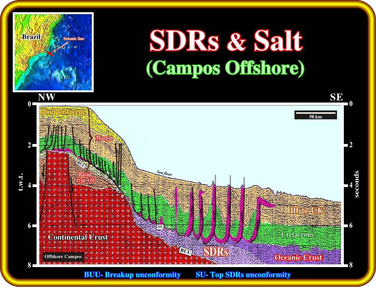
On this geological tentative interpretation of regional line of Campos offshore, it is easy to consent that the the formation of rift-type basins seems to be restrained to the continental crust. In fact, the continental crust was lengthened by normal faulting with formation of rift-type basins. However, since the breakup of the lithosphere took place, the continental crust was anymore lengthened, but drifted. Certain geoscientists go further : they think that when the thickness of the continental crust, during the lengthening, reach 10-15 kilometres, which corresponds, more or less, to β ± 4 (coefficient of extension), the continental crust cannot anymore be lengthened by normal faulting. It becomes, highly, injected by mantle material. Eastward, below the margin sediments, the trilogy Continental Crust (rift-type basins included), Seaward Dipping Reflectors and Oceanic Crust, is perceivable. The breakup unconformity (BUU) is, readily, recognized in the western part of the line, where it separates the rift-type basins from the margin infra-salt sediments and but in the central part, where it is fossilized by the onlapping of the SDRs. The SU unconformity (top of the SDRs) and top of the oceanic crust is also recognized either at the bottom of the salt (and associated salt welds) and, seaward, by the hummocky morphological interface between the sediments and oceanic crust. Seismically speaking there not SDRs overlying the rift-type basin. On other words, if there are SDRs overlying the rift-type basins, their thickness is under seismic resolution. Once again, forewarn the pitfalls induced by the abrupt changes in water depth.
1.3- Espirito Santo Offshore
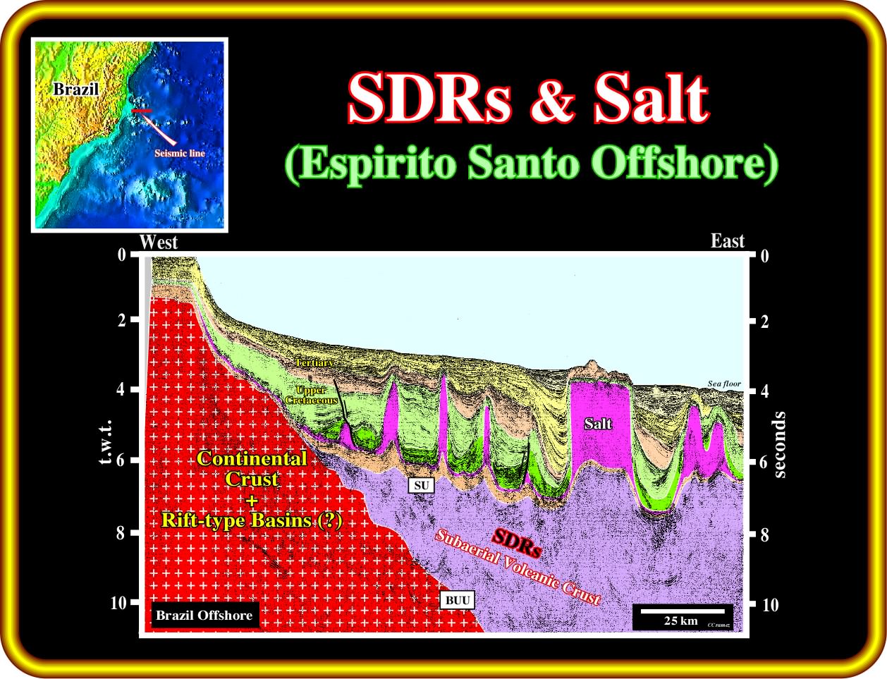
On this geological tentative interpretation of regional seismic line of the Espirito Santo basin, the substratum of the margin sediments is composed by seaward dipping reflectors. In this part of the basin there area not rift-type basins, since they predate the emplacement of the subaerial lava flows. Below the evaporitic interval, particularly in the western part of the line, infra-salt sediments are recognized readily. A thick post-breakup subaerial volcanic interval (seaward dipping reflectors) forms the infrastructure of the margin. The undulatory geometry of the SU unconformity (top of the SDRs) is induced to the lateral velocity changes induced by the evaporitic interval and Tertiary depocenters. The seaward dipping of the subaerial lava flows is not to evident due since the reflectors below the salt interval area chiefly masked.
2- Eastern Offshore USA
2.1- Gulf of Mexico
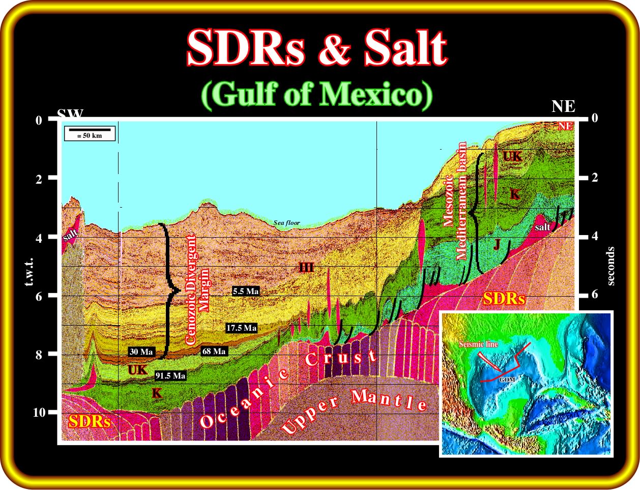
This geological tentative interpretation of a composite seismic line across the Gulf of Mexico corroborates the hypothesis of that the opening of the Gulf of Mexico corresponds to a volcanic margin. In fact, there is a strong evidence of volcanic structures, which lateral succession suggests a progressive drowning of the spreading centres. The transition of the subaerial volcanic crust (SDRs) to the oceanic crust (sheeted dykes) is quite plausible. Above the volcanic crust it is easy to recognize a Mesozoic Mediterranean-type basin overlain by a Cenozoic divergent margin. In the middle of the seismic line, the distal part of the deepwater Mississippi fan is obvious to the eye.
2.2- Virginia Offshore
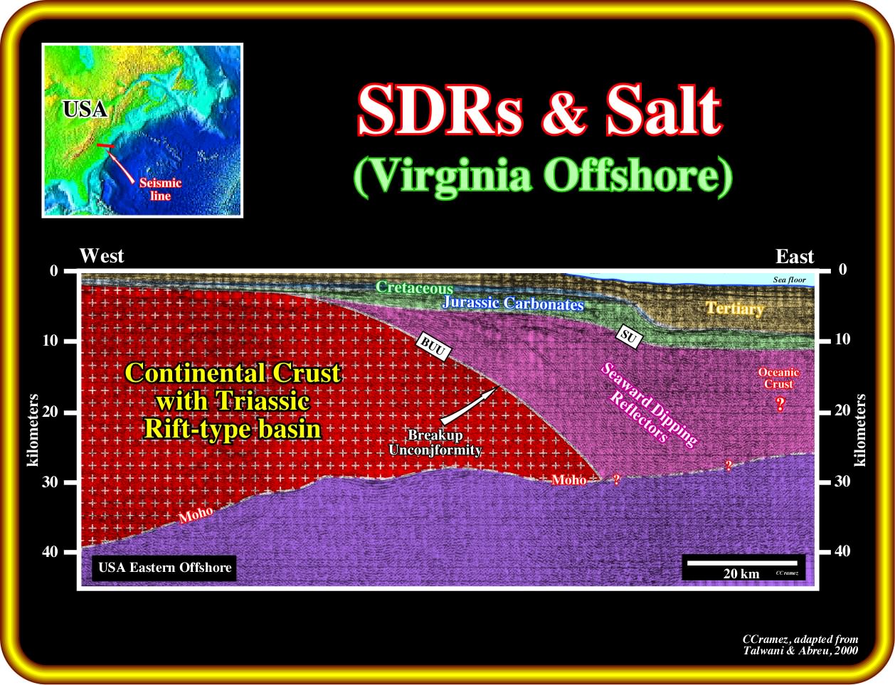
In this geological tentative interpretation of a regional seismic line of the Virginia offshore, not far from the Baltimore Canyon, large seaward dipping reflectors are recognized. They strongly suggests that the USA Atlantic margin is a typical volcanic margin, contrariwise to what was though before (under the influence of the interpretation of the Galicia offshore proposed several European geoscientists). In fact, as depicted, the substratum of the margin sediments is essentially composed by seaward dipping reflectors, which fossilize the breakup unconformity. Take notice that in this tentative, the continental crust include the Triassic rift-type basins developed during the lengthening of the Pangea, which foreshadows the breakup of the lithosphere.
2.3- New Jersey Offshore
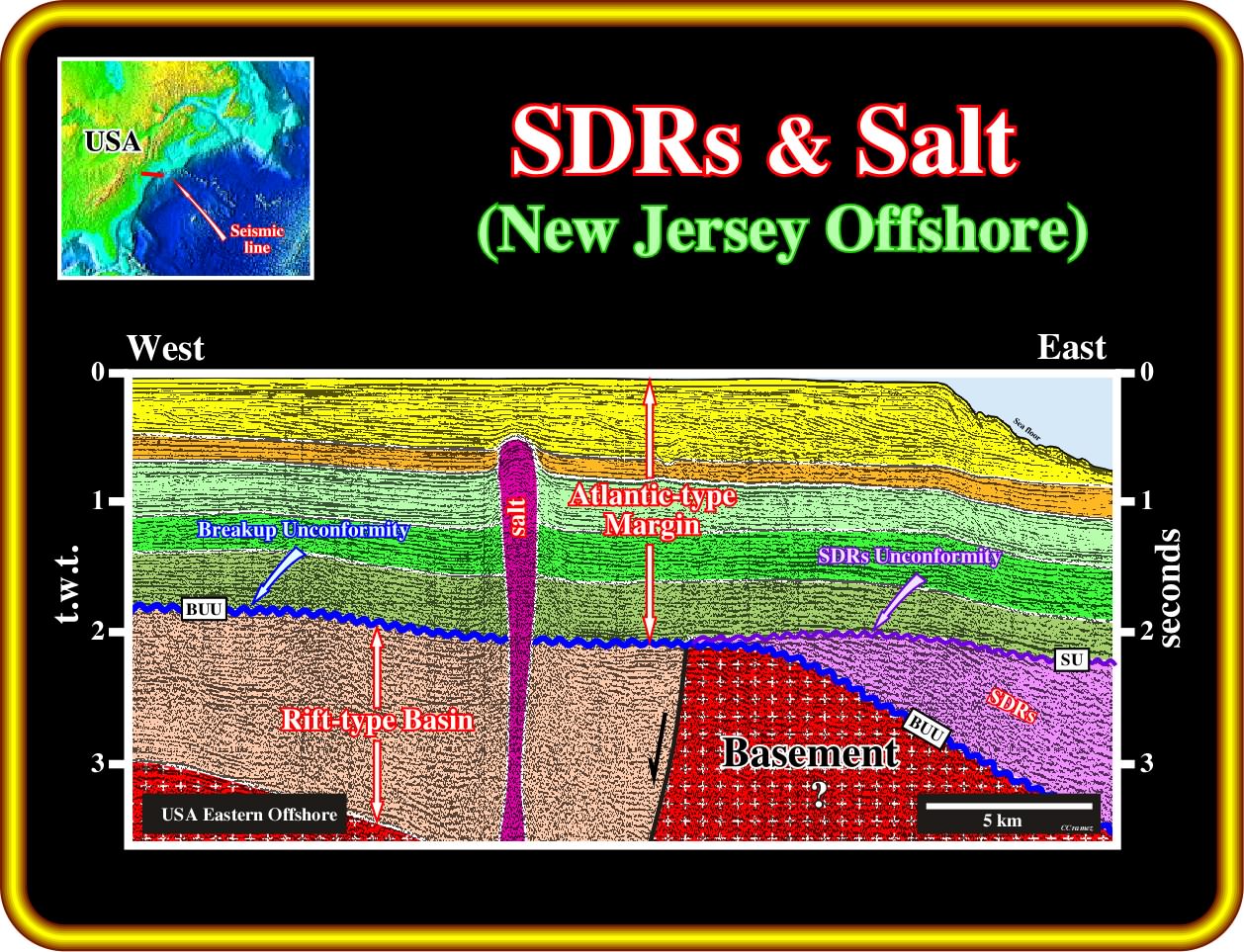
On this geological tentative interpretation of a seismic line of Baltimore Canyon (USA Eastern offshore), not only seaward dipping reflectors are obvious (in eastern part of the line), but a Triassic rift-type basin as well. A salt diapir is visible in the middle of the line. However, and contrariwise to the what happen in Angola - Congo salt basins, the mother rocks of this diapir belongs to the rift-type basin, that is to say, the salt layer predates the breakup unconformity and its chemistry and mineralogy is quite different of the Loeme salt. Consequently, this offshore is not a real analog of the Congo - Kwanza. In the upper part of this tentative a downlap surface separates the stratigraphic phases (transgressive and regressive) of the continental encroachment post-Pangea stratigraphic cycle. The picking of the breakup unconformity (BUU) is obvious. The SDRs are bounded between the BUU and SU unconformity. The normal fault bordering the Triassic rift-type basin is easily picked. The upper limit of the rift-type basin is the breakup unconformity. The salt diapir, which allow us to infer the presence of a mobile evaporitic layer within the rift-type basin, is quite interesting since in the Kwanza onshore, an exploratory well drilled, in the 60's, by Petrangol (Fina), i.e., Maculongo, recognized two salt layers. The upper layer was deposited in the margin, while the lower one was deposited in the Maculongo rift-type basin.
3- Canada Offshore
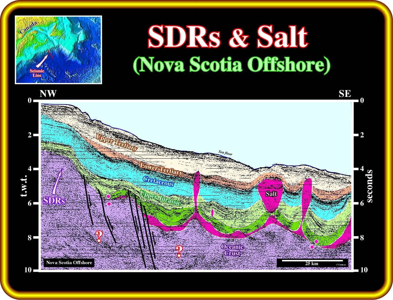
On this geological tentative interpretation of a regional seismic line of the Nova Scotia offshore, the more likely substratum of the margin sediments is volcanic crust. The absence of rift-type basins corroborates the conjecture that the SDRs postdate the breakup unconformity. Potential subaerial lava flows are more likely in the western part ; in the eastern part of the line, oceanic crust may be prevailing.
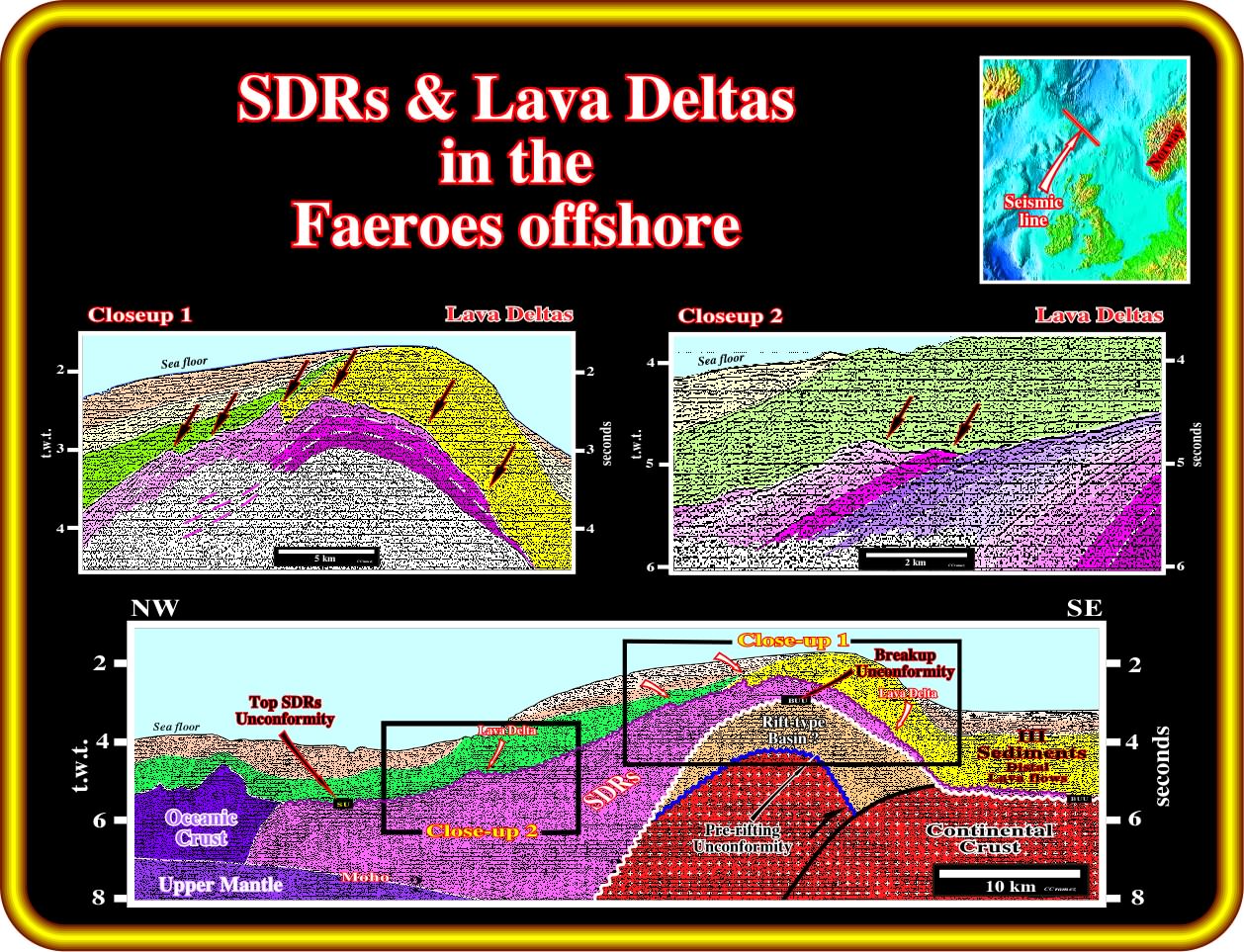
Seaward dipping reflectors and associated lava deltas are quite frequent in North Atlantic margins, as illustrated in this geological tentative interpretation of a regional seismic line of the Faeroes offshore. In fact, as depicted, above the breakup unconformity an important volcanic interval was deposited. It fossilized the broken continental crust and the rift-type basins developed in it during the lengthening of the lithosphere. A local compressional tectonic regime reactivated, as reverse faults, the old normal faults bordering the rift-type half-grabens, shortening not only the pre-breakup sediments, but the post breakup as well. On the close-ups 1 and 2, the dipping and thinning of the SDRs are easily recognized, as well as the lava deltas, which, often, are interpreted as fault escarpment, particularly by naive interpreter geoscientists. Resembling volcanic structure are found in Congo and Kwanza basin, particularly near the western edge of the salt basin and in the Kwanza onshore, near Cabo Ledo area.
On this subject, it is important to point out the possible presence of graben or half grabens structures affecting the seaward dipping reflectors, that is to say, posdating the breakup unconformity (contrariwise to the rift-type basin), as it is the case in several area in the North Atlantic margins (West Greenland offshore for instance) as illustrate next.
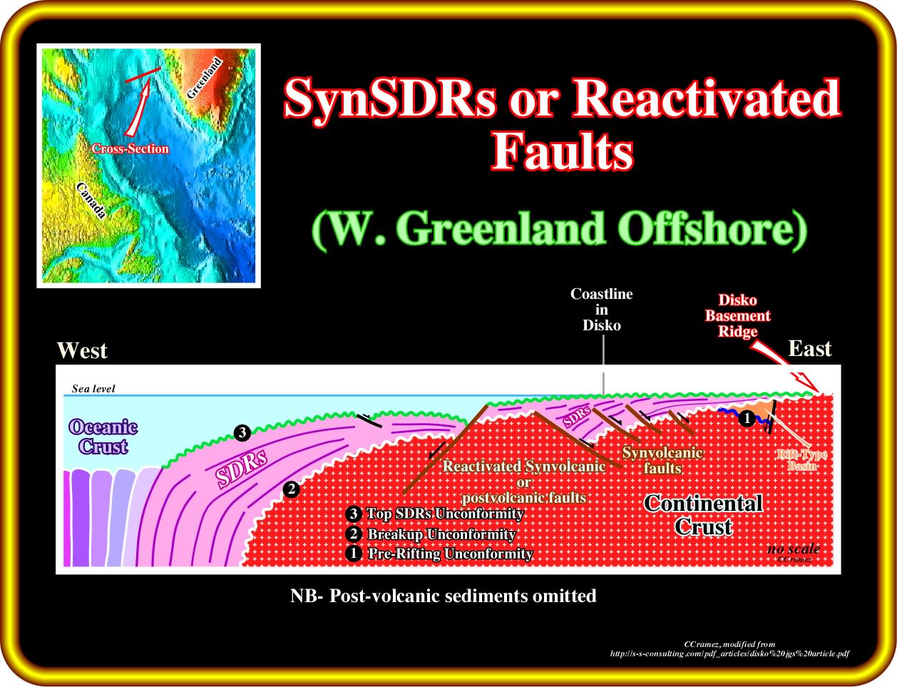
In this schematic model of the seaward dipping reflectors (SDRs) deposition in the onshore and proximal offshore of the western Greenland, the SDRs, which, globally, thin landward (flowing outward from the vents of the subaerial spreading centres, that is to say, in direction of the opposite individualized continents) can infill small syn-volcanic half-graben with a seaward vergence (the normal fault dip landward). Such a syn-volcanic extensional structures should not be confounded with rift-type basins, which are contemporaneous and developed in association with the lengthening of the continental crust, before the breakup. Such confusion, i.e., interpret syn-volcanic extensional structures as rift-type basin, is frequent done by geoscientists verificationists, who, despairingly, try to find in Congo - Kwanza offshore, where the mantle seems to have been active, the model proposed in Galica offshore (where the mantle seems to have been passive), which, probable, corresponds to a non-volcanic margin (see the plate after the next). Similarly, the half-grabens structures developed at the base of depocenters in answer to a volume problem (increasing) created by the subsidence cannot be interpreted ay rift-type basins, since they posdate deposition and do not correspond to a regional lengthening of the continental crust.
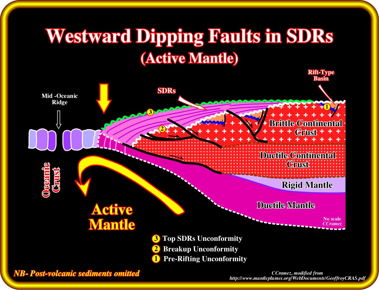
Certain geoscientists explain the subaerial lava flows and particularly the formation of the half-grabens in North Atlantic as a consequence of a strong mantle activity (inward convection motion), which induces a post break lengthening of the crust (mainly of the upper brittle crust) by normal faults, generally looking toward the continent, since after the breakup of the lithosphere, that is to say, during and the deposition of the SDRs, the space available for lengthening is along the break zone where are located the spreading centres. Notice that the normal faults bordering the rift-type basin dip, almost always, seaward.
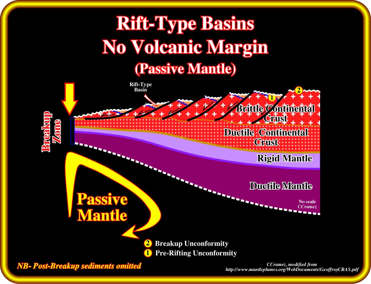
In a non-volcanic continental margins, as it seems be the case in Galicia and Flemish Cap, the absence of subaerial lava flows and strong lengthening of the lithosphere over a detachment surface, the mantle is passive (outward convention motion). In the Atlantic margins, a non-volcanic margin in which the continental breakup made by extremely lengthening of the continental crust is just recognized in Galicia offshore and eventually in the area of Flemish Cap (Canada offshore). All other margins a volcanic with an active mantle as illustrated in the previous last plate. It is interesting to point out the absence of salt either in Galicia as well as in Fleming Cap offshore, in spite of the fact that the latitude of these offshore does not favour and evaporitic depositional systems.
Exercise 1 :
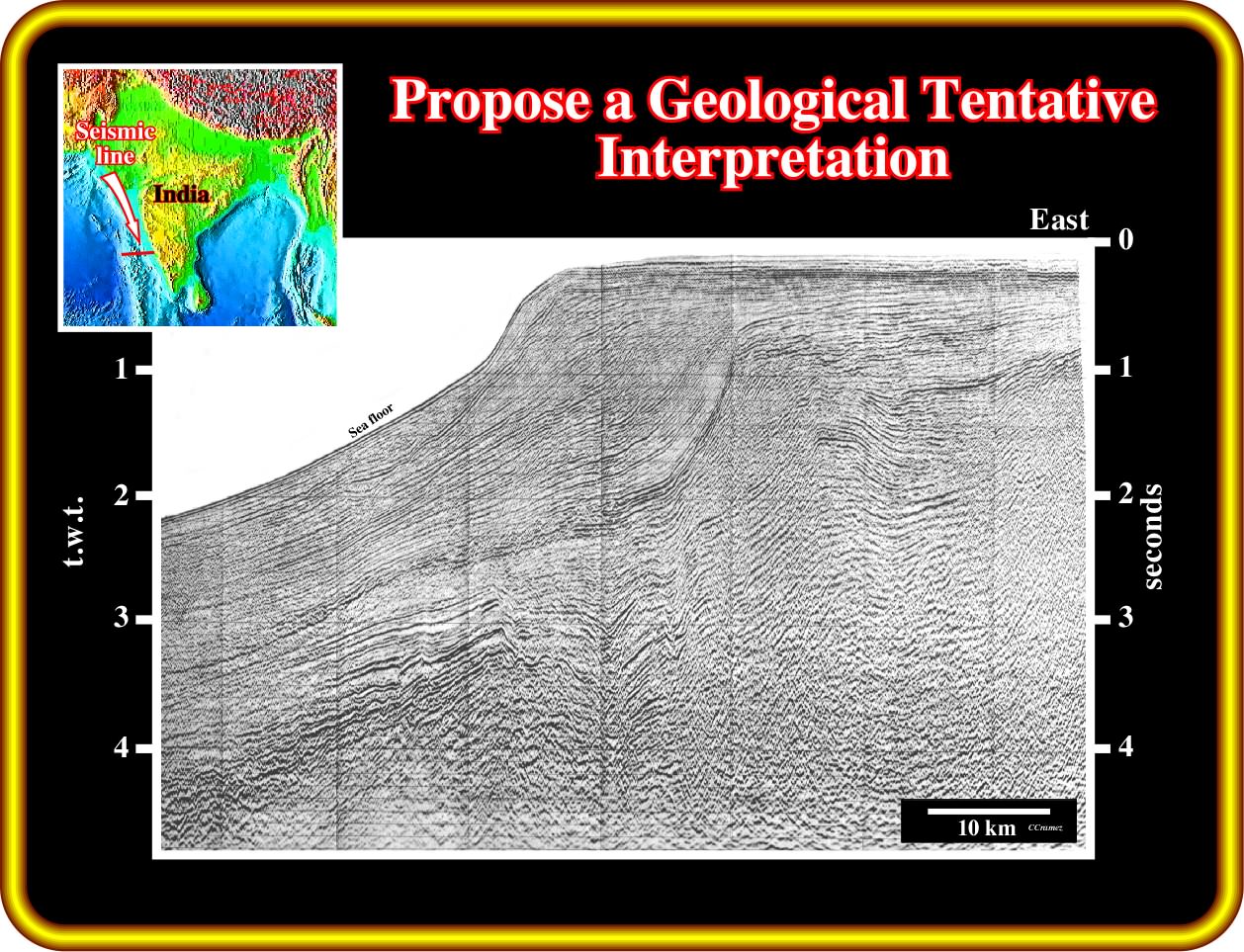
Propose a tentative geological interpretation of this seismic line of the Western India offshore, taking into account that you must recognize:
(i) The basement ;
(ii) The breakup unconformity ;
(iii) The rift-type basins ;
(iv) The Atlantic-type divergent margin ;
(v) The subaerial lava flows ;
(vii) Are the SDRs postdatin or predating the breakup unconformity ?
Exercise 2 :
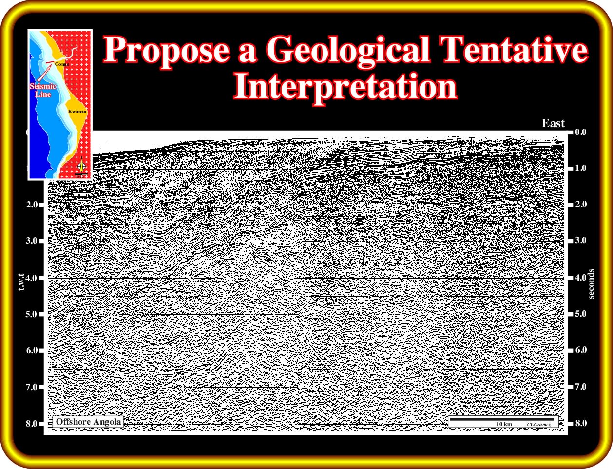
On this seismic line of the deep South Congo offshore, you must locate two step at the top of the infra-salt sediments. Then,
(i) Pick the salt welds ;
(ii) Pick the limits of the salt ;
(iii) Pick the breakup unconformity ;
(iv) How many rift-type basins do you recognize on this line ?
(v) Propose a stratigraphy of the infra-salt sediments.
(v) Calculate, roughly, the amplitude of the Later Tertiary uplift.
Exercise 3 :
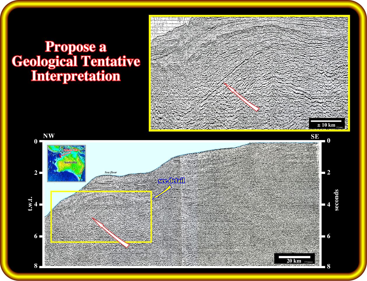
Make a plain and comprehensible geological tentative interpretation of this seismic line. Then, take a sheet of paper an write what an interpreter geoscientist must recognized on this line of an volcanic Atlantic-type divergent margin. Do not forget, that in Geology and particularly in seismic interpretation all observations are theory dependent.
to continue press
next
![]()