

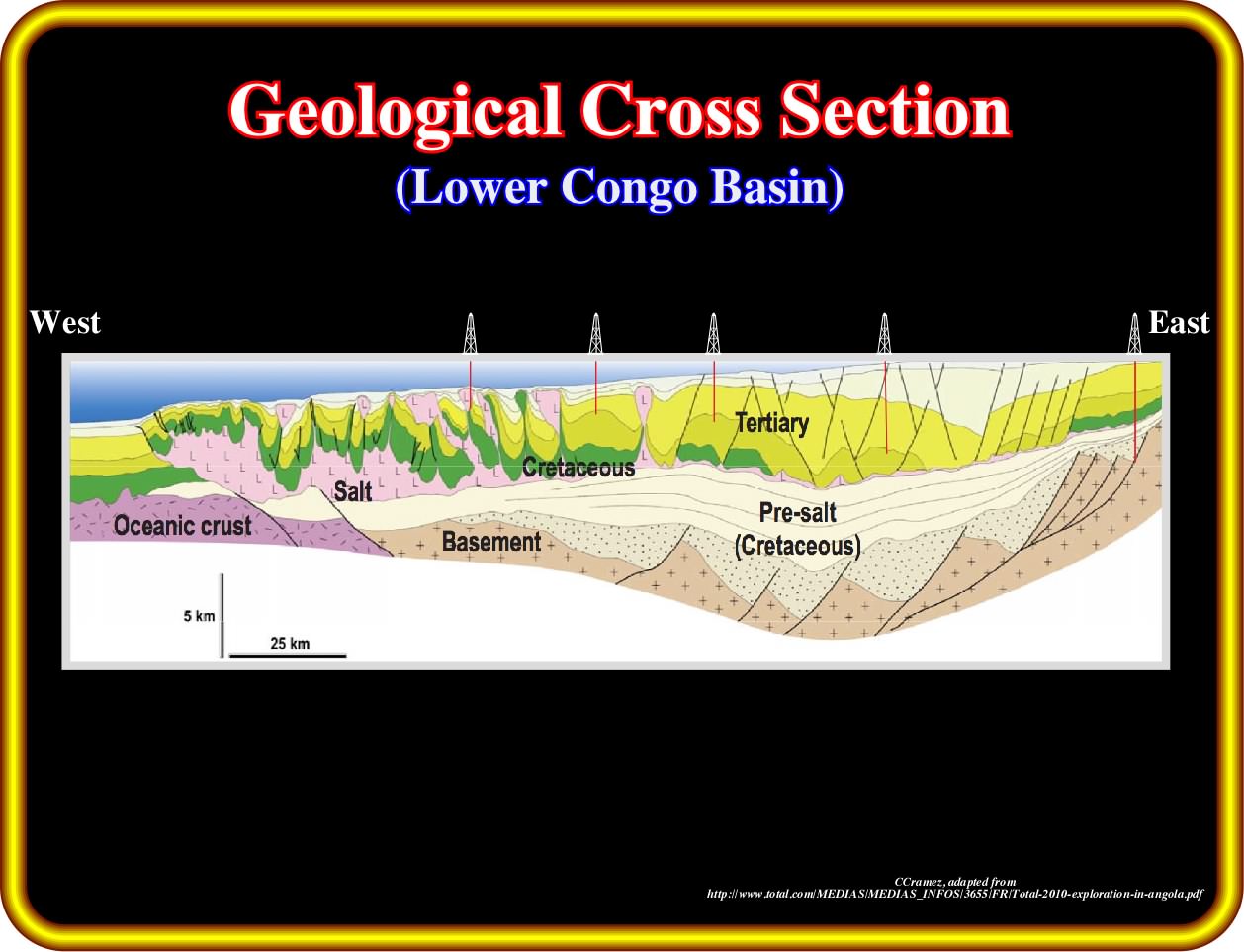
As illustrated on this map, in the area of Ambriz city ( midway between Soyo and Luanda), the eastern edge of the Cretaceous sediments of divergent margin almost reaches the shoreline In fact, in this area, the basement (granite gneiss with garnets) forms a kind of headland (known as Ambriz arch) which separates two large sedimentary indentation over the basement. The northern corresponds to the Congo basin, which geoscientists, often, subdivided in North and South Congo basin using the path followed by the Congo river. The southern sedimentary prism corresponds to the Kwanza basin, since it is crossed by the Kwanza river, which is much less important that the Congo River. As illustrated by the map of the isobaths of the basement, the configurations of these two basins are quite different. The large trough visible in the Kwanza onshore (Inner Kwanza basin) seems absent in the Congo basin. On the other hand, not only the sedimentary encroachment (in relation to the shoreline) is much important in Kwanza basin, where, as we will see later, there is a inner Aptian salt depocenter that does exist in the Congo basin. On the contrary, since the Congo river cut the coastal escarpment (induced by a regional Late Tertiary uplift) to found its mouth, a strong terrigeneous influx created, in deep water offshore, a large Tertiary turbiditic depositional system, which is, practically, inexistent in Kwanza offshore.
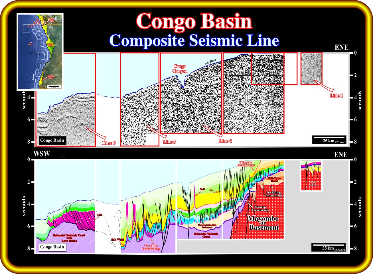
On this composite regional seismic line, the western most line, where the thickening of the salt layer by thrusting is obvious, belongs, as illustrated on the location map, to the Kwanza basin (similar seismic line showing the western edge of the salt basin exist in Congo basin and will be shown later). Before illustrating each component line, one can, already, say that : (i) Two significant fracture zones are crossed by this composite line ; (ii) the Late Tertiary uplift is easily recognized continentward of the eastern fracture zone ; (iii) Rift-type basins, developed during the lengthening of the Gondwana, i.e., predating the breakup of the lithosphere, are recognized landward of the eastern fracture zone within the continental crust ; (iv) Seaward of the eastern fracture zone, there is not evidence of continental crust, since the margin sediments lie on a volcanic crust, probably subaerial (seaward dipping reflectors) ; (v) An huge margin infra-salt depocenter is visible between the two fracture zones ; (vi) A Tertiary depocenter, mainly composed by sand-shale turbiditic systems, developed seaward of the eastern fracture zone in association with the Late Tertiary uplift, which strongly increased the terrigeneous uplift.
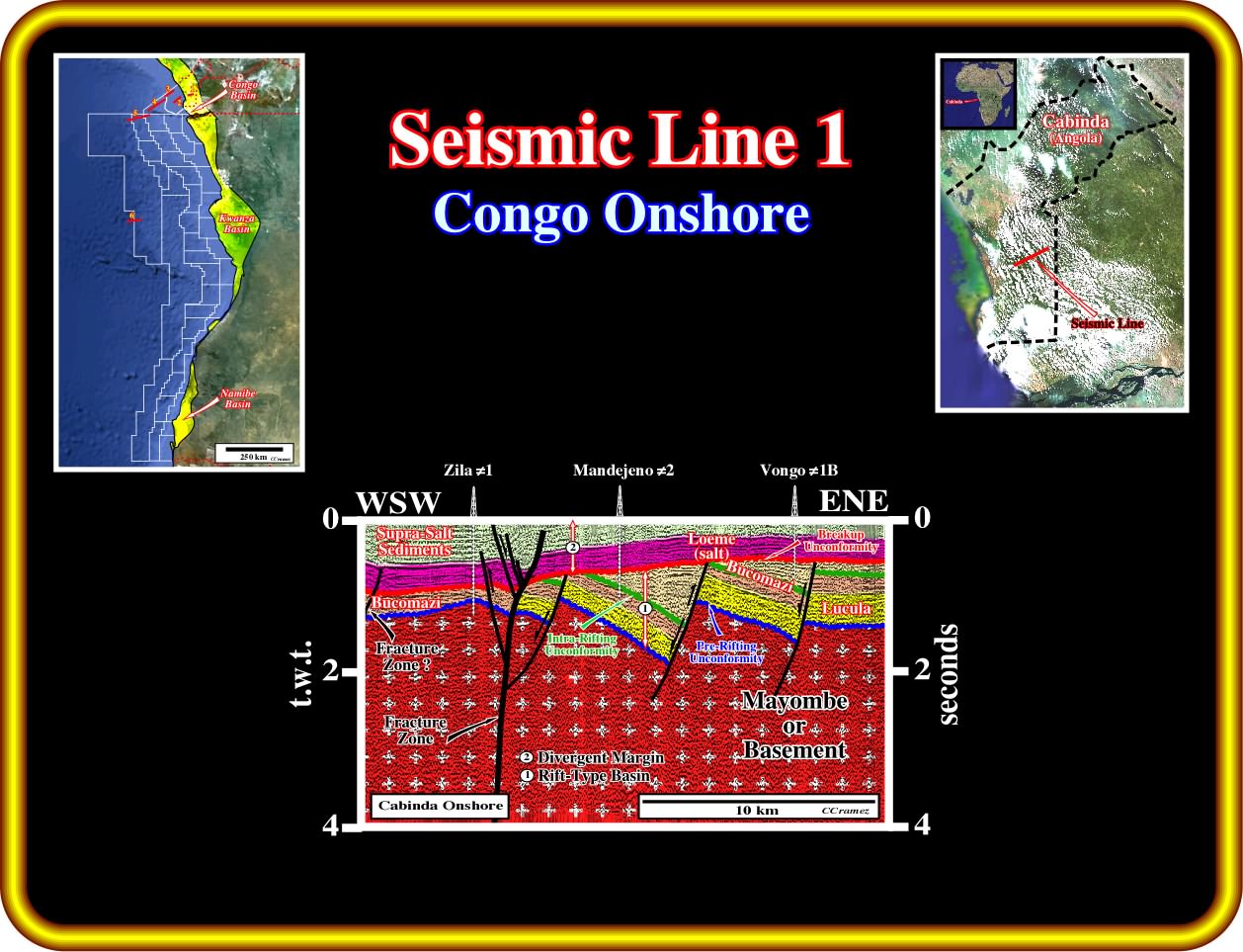
This component seismic line is located in the onshore of the Congo basin (southern area of Cabinda). The proposed geological tentative interpretation clearly illustrated several rift-type basins. These basins have an half-graben geometry and are bounded by two important unconformities (erosional surfaces). The lower one is the pre-rifting unconformity and the upper one is the breakup unconformity. It is important to notice that the geometrical relationships between the seismic reflections within these rift-type basins allow to put in evidence an erosional surface (unconformity) within the rift-type basin sediments. Three principal sedimentary intervals can be recognized in these rift-type basins (from bottom to top) : (i) Lucula ; (ii) Lower Bucomazi and (iii) Upper Bucomazi. The intra-rift type basins unconformity separates the Lower Bucomazi from the Upper Bucomazi. Seismically speaking, that is to say, taking into account the seismic resolution, the salt layer (Aptian) rests on the breakup unconformity (the Chela formation is, here, under seismic resolution). A fracture zone is visible in the eastern part of the seismic line between Zila ≠1 and Mandejeno ≠2 wells.
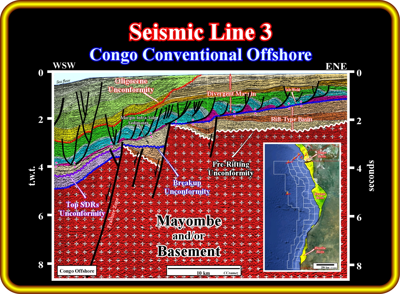
This seismic line, located between the component 1 and 2 of the composite seismic line of the Congo basin illustrated previously, is quite interesting. In fact, the organic rich interval (Lower Bucomazi) is easily recognized (in brown on the geological tentative interpretation). Here, the basement corresponds to the Mayombe formation, which seems to be an Paleozoic folded-belts (granite-gneiss can be present locally). The pre-rifting unconformity (white wavy line) and the breakup unconformity (dark blue wavy line) bound a rift-type basin, in which the trilogy Lucula, Lower Bucomazi and Upper Bucomazi is easily recognized. Above the breakup unconformity and below the salt layer (or associated primary salt welds), the sandstones of the Chela formation are, locally, visible. On the other hand, the salt induced tectonic disharmony, which separates the deformed margin supra-salt sediments (salt included) from undeformed margin infra-salt sediments, is perceived all along of the seismic line. It is important to point out that, often, near the western wedge of the rift-type basins (half-graben geometry), i.e., in the less subsiding area, lacustrine reefal buildups are possible (Toca Formation) .
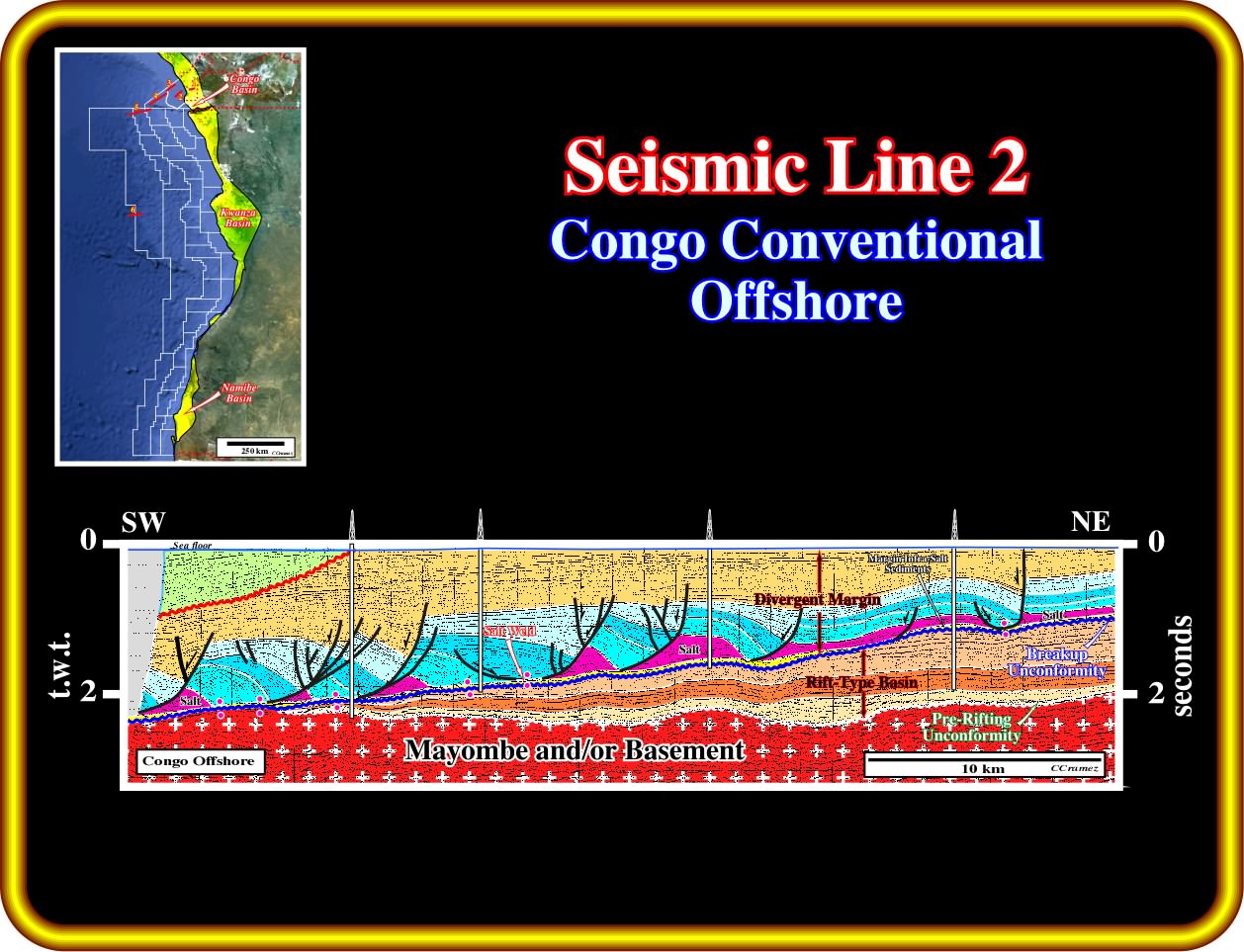
This seismic line is the second component of the composite seismic line illustrated previously. As suggested by the proposed geological tentative interpretation, it illustrates the western limit of the rift-type basins. Take note that this personal conjecture is not, so far, shared by many of my friends working in Angola, which are convinced that rift-type basins exist seaward, in spite of the fact that they don't have any proof of that (remember what Nietzsche said : "Convictions are the enemies of the truth and more dangerous that lies" ). However, as will see all along of these notes, the absence of rift-type basins in the deep water offshore is difficult to refute. The rift-type basins are bounded by the pre-rifting and breakup unconformities. Their half-graben geometry, with the bordering normal faults looking seaward, is composed by three seismic intervals with he middle one rich in organic matter (potential source rocks intervals). Seaward of the fracture zone, a subaerial volcanic interval (seaward dipping reflectors) with a small percentage of clastic sediments was deposited immediately above of the breakup unconformity. Overlying the subaerial volcanic interval (postdating de breakup unconformity), margin infra-salt clastic sediments are recognized, since their thickness is largely higher than the seismic resolution. The bottom of the salt interval and associated primary salt welds mark the salt induced tectonic disharmony, which separates the deformed and undeformed margin sediments. Note, that at the sea floor, the reflections terminations underline the Late Tertiary uplift of the eastern part of the margin sedimentary prism, in which the Oligocene unconformity (probably induced by a worldwide relative sea level fall) is easily recognized.
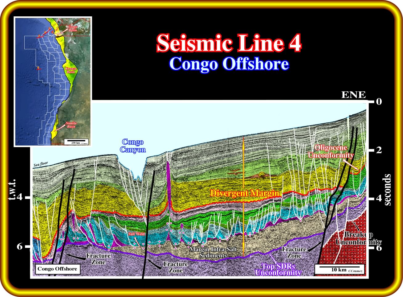
On this seismic line, which cross the recent Congo canyon, the margin infra-salt sediments are, here, greatly developed above of volcanic crust assumed to postdate the breakup unconformity (white wavy line). In fact, any evidence of rift-type basins (half-graben structures) is perceived below the infra-salt margin sediments. As depicted in the geological tentative interpretation, above the top SDRs unconformity (violet wavy line), a thick sedimentary interval (mainly sand-shales, with, locally, carbonates) is easily recognized. In this area, as well as in all offshore Congo basin, this interval was not yet recognized by drilling. However, taking into account the results of the wells drilled in the conventional Kwanza offshore, the presence of the organic rich sedimentary intervals, that is to say, intervals with potential source and reservoirs-rocks layers are possible, which can form an unexplored potential petroleum system. It is interesting to notice that such a margin infra-salt sedimentary depocenter is located between two major fracture zones. Above the infra-salt margin sediments, and particularly, above the margin sediments overlying the salt induced tectonic disharmony, the retrogressive sediments of the transgressive phase of the post-Pangea continental encroachment stratigraphic cycle are individualized from the progradational sediments by a major downlap surface, which seems to correspond to greatest Meso-Cenozoic eustatic high. The Oligocene unconformity (red wavy line) is easily recognized.
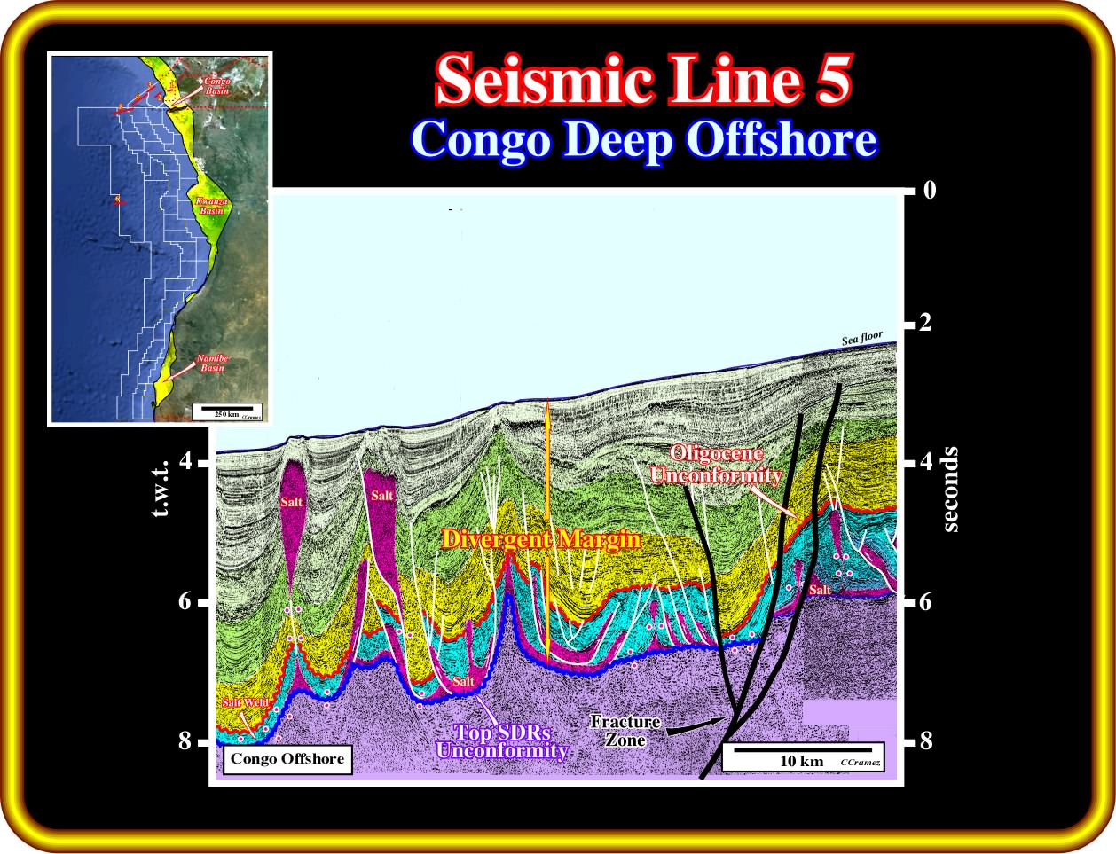
On this seismic line, it is important to notice that the substratum of the margin sediments seems to be a subaerial volcanic crust. There is any evidence of a lengthening of a continental crust, as for instance, the presence of rift-type basins. On the contrary, the presence of few seaward dipping reflectors favour the hypothesis of subaerial volcanic crust postdating the breakup of the Gondwana lithosphere. The top of the volcanic crust unconformity is, here, fossilized by the autochthonous salt layer or associated primary salt welds, that is to say, by the salt induced tectonic disharmony. Notice that in the eastern part of this line, the tectonic disharmony is strongly displaced by a fracture zone, i.e., the bottom of the salt layer is vertically shift ( more or less 1 second, two way time), even taking into account the seismic artefact induced by the lateral velocity changes. Finally, this line illustrates quite well the local compressional (shortening) tectonic regime induced not only by the reactivation of the fracture zones (relative movement of the lithospheric plates during the sea floor spreading) but by the seaward gliding of the salt layer as well.
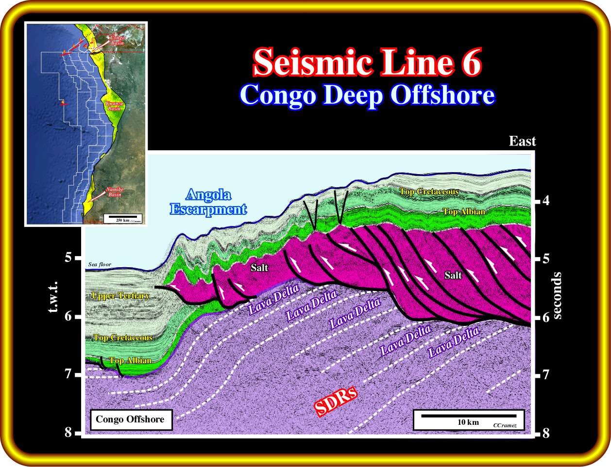
This seismic line illustrates not only the western edge of the salt basin, but the considerable thickening of the salt layer by thrusting, that is to say, the ample stacking of salt thrusts. In certain seismic lines, the western border of the salt basin seems to be marked by normal faulting. However, in this line an alternative interpretation is conceivable. In fact, taking into account the presence of seaward dipping reflectors, i.e., lava flows (subaerial since volcanic material cannot flows under water) thinning and moving continentward, the development of lava deltas is unsurprising whenever the lava enters a standing water body (lake or epicontinental sea). In such hypothesis, the slope of the lava deltas can locate the kickoff of the thrusting faults, created to shorten the salt layer, without the need of preexistent normal fault. On the other hand, this seismic line, and particular the proposed geological tentative interpretation, explain quite well the Angola escarpment and the associated supra-salt folded belt, by shortening and lateral seaward displacement.
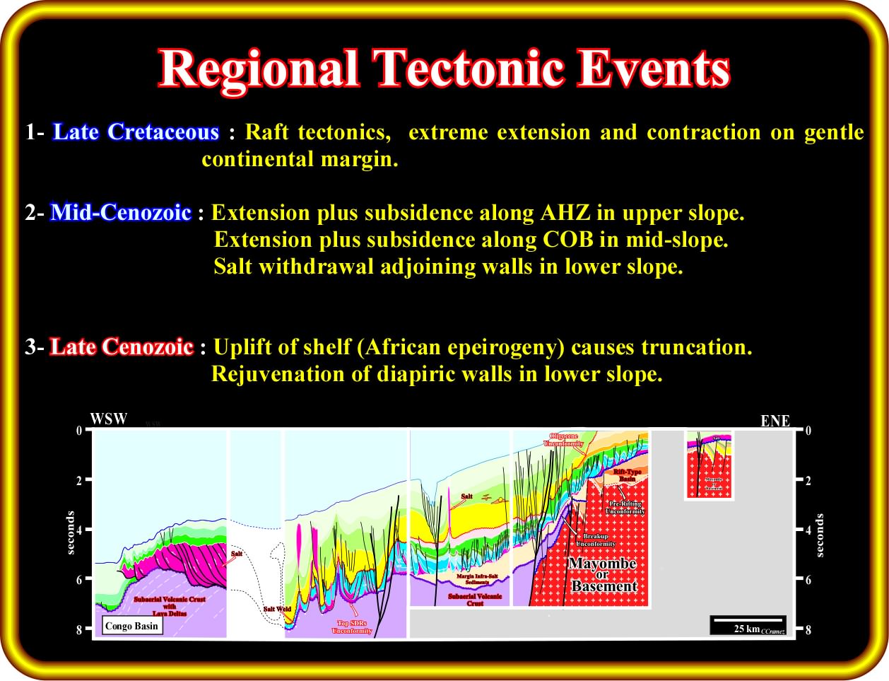
The following regional tectonic events can be deducted from this geological tentative interpretation of the composite seismic line of the Congo basin illustrated previously : (i) During the Lower Cretaceous - (a) Lengthening of the Gondwana continental crust with development of rift-type basins, in which the deposition of rich organic lacustrine sediments is likely ; (b) Breakup of the Gondwana lithosphere with a local individualization of the Africa and South America lithospheric tectonic plates ; (c) Emplacement of lava flows (SDRs) in association with the subaerial expansion, which took place immediately after the break of the lithosphere ; (ii) During the Upper Cretaceous - (a) Salt induced rafting tectonics ; (b) Extreme extension (lengthening) and contraction (shortening) on a gentle divergent continental margin ; (iii) During the Middle Cenozoic - (a) Extension and subsidence, in the upper continental slope, along the Atlantic Hinge Zone ; (b) Extension and subsidence, in the middle slope, along the continental oceanic boundary (COB) ; (c) Salt withdrawal adjoining walls in the lower slope ; (iii) During the late Cenozoic : (a) Uplift of the shelf (African epeirogeny), which causes an widespread truncation ; (b) Rejuvenation of diapiric salt walls in the lower slope ; (c) Duplex thrusting of the salt with uplifting of the overburden ; (d) Steepening of the sea floor, which initiates extension (lengthening)above the paleoescarp (Angolan escarpment).
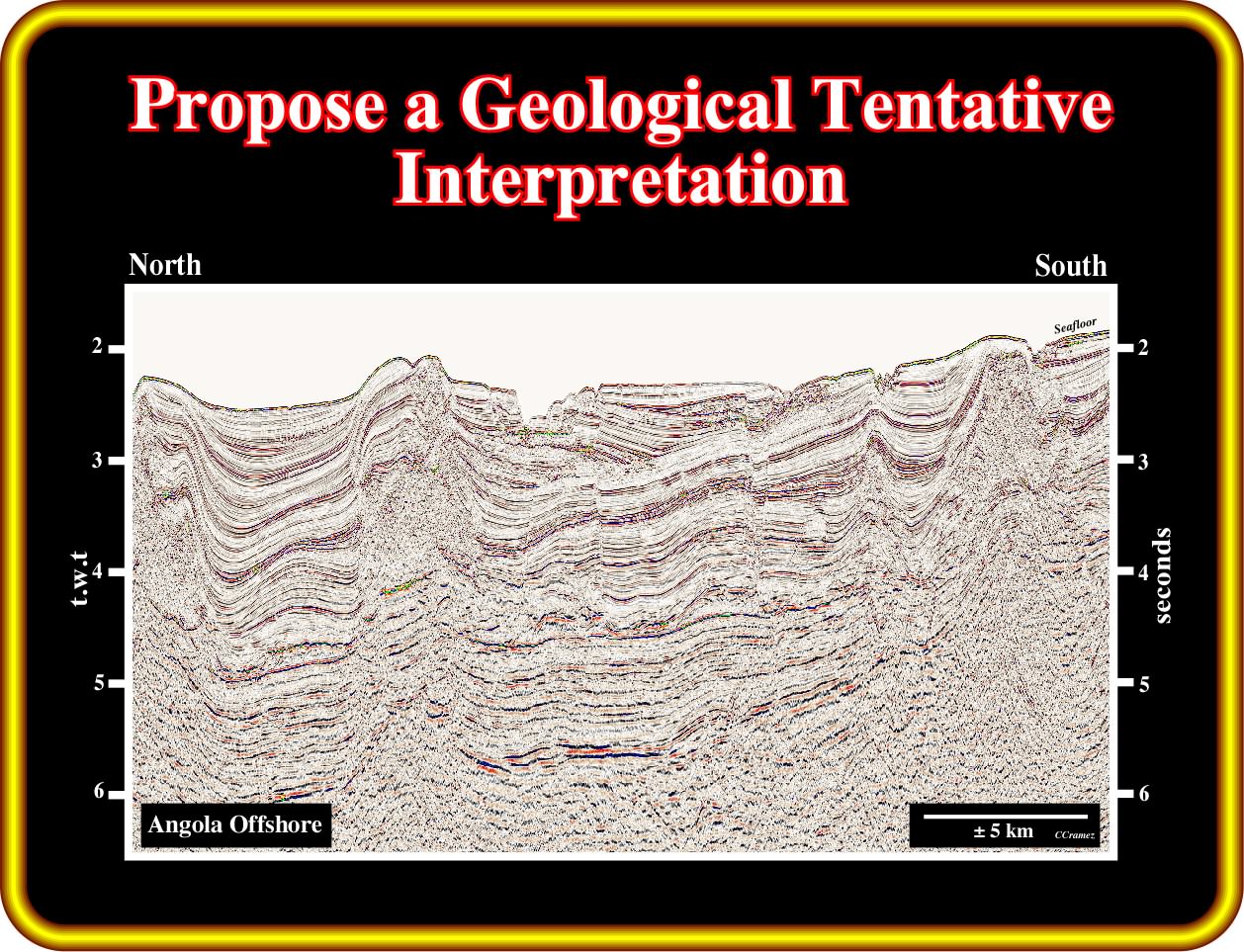
Exercise 1:
Exercise 2:
to continue press
next
. ![]()