
7- What can be learned from of South Congo seismic lines ?
Let's use some offshore South Congo seismic lines to test, that is to say, to criticize the geological tentative interpretations proposed in the previous chapter, in which the infrastructure of the thick margin infra-salt sediments is interpreted as subaerial volcanics emplaced immediately after the breakup unconformity, since there is any clear evidence of rift-type basins. In fact, the rift-type basins, developed during the lengthening of Pangea continental crust and bounded by the pre-rifting and breakup unconformity, are just obvious in the onshore and conventional (water depth less than 200 metres) offshore seismic lines where their were tested by exploration wells.
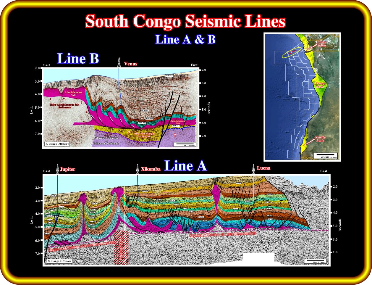
These geological tentative interpretation of two seismic lines mainly located southward the Congo Canyon (visible on the eastern part of the lower seismic line, eastward of Luena well) strongly suggest : (i) The presence a major fracture zone (visible one both seismic lines), which displaced the bottom of the salt and associated primary salt welds (salt induced tectonic disharmony) ; (ii) A possible evidence of margin infra-salt sediments on the upper seismic line (line B), downward of the location of Venus well, which can also be eventually present on the seismic line A in the area of Jupiter well, i.e., seaward of the picked fracture zone ; (iii) A credible absence of rift-type basins in the substratum of the margin sediments, which favour a volcanic facies substratum rather a continental crust (the development of rift-type basins is only possible within the continental crust, which predates the lengthening of the lithosphere) ; (iv) A compressional tectonic regime induced either by reactivation of fracture zones due to the adjustment of the lithospheric plates or as a reaction to the updip gravitational extension, particularly of the salt layer.
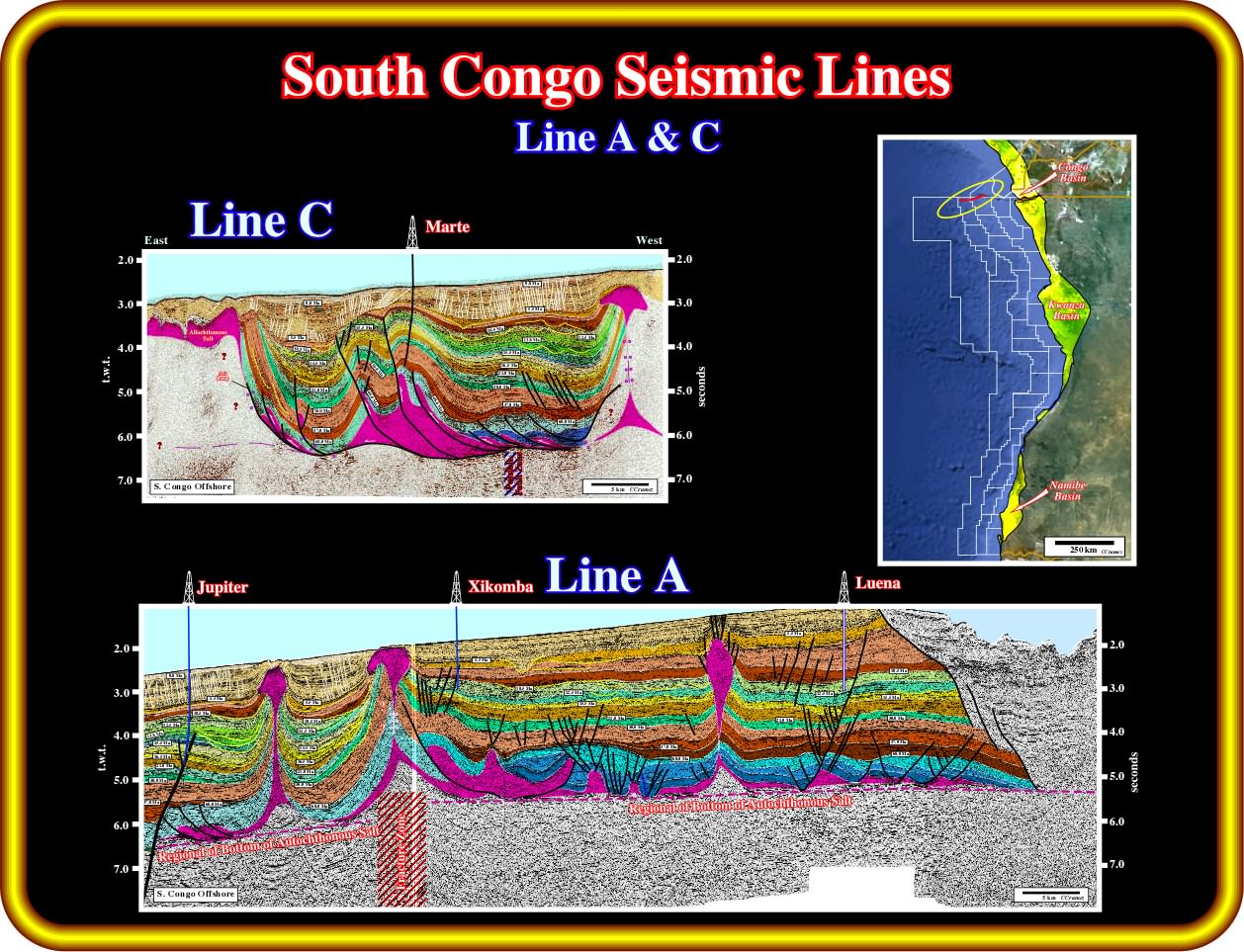
Concerning the interpretation of infra-salt strata, which are the main objective of these notes supporting the workshop, the consequences of the geological tentative interpretations of these two seismic lines (the line A is the same that interpreted in the previous plate) are the same as before, that is to say : (i) Absence of rift-type basins ; (ii) Probable volcanic nature of the sedimentary substratum ; (iii) Presence of a major fracture zone, which displaces vertically the salt induced tectonic disharmony ; (iv) Absence of a clear evidence of a margin infra-salt sediments ; (v) Evidence of allochthonous salt layers and secondary vertical salt welds, which correspond to squeezed salt diapirs ; (vi) Presence of a compressional tectonic regime in middle lower slope affecting mainly the salt and supra-salt sediments, but not only. It is interesting to notice that, in deep offshore, the exploration wells have targeted mainly compressional traps (not necessarily structural traps, i.e., four way dips), while in upper slope and continental platform, they have target mainly extensional traps (morphological and by juxtaposition).
Exercise 1:
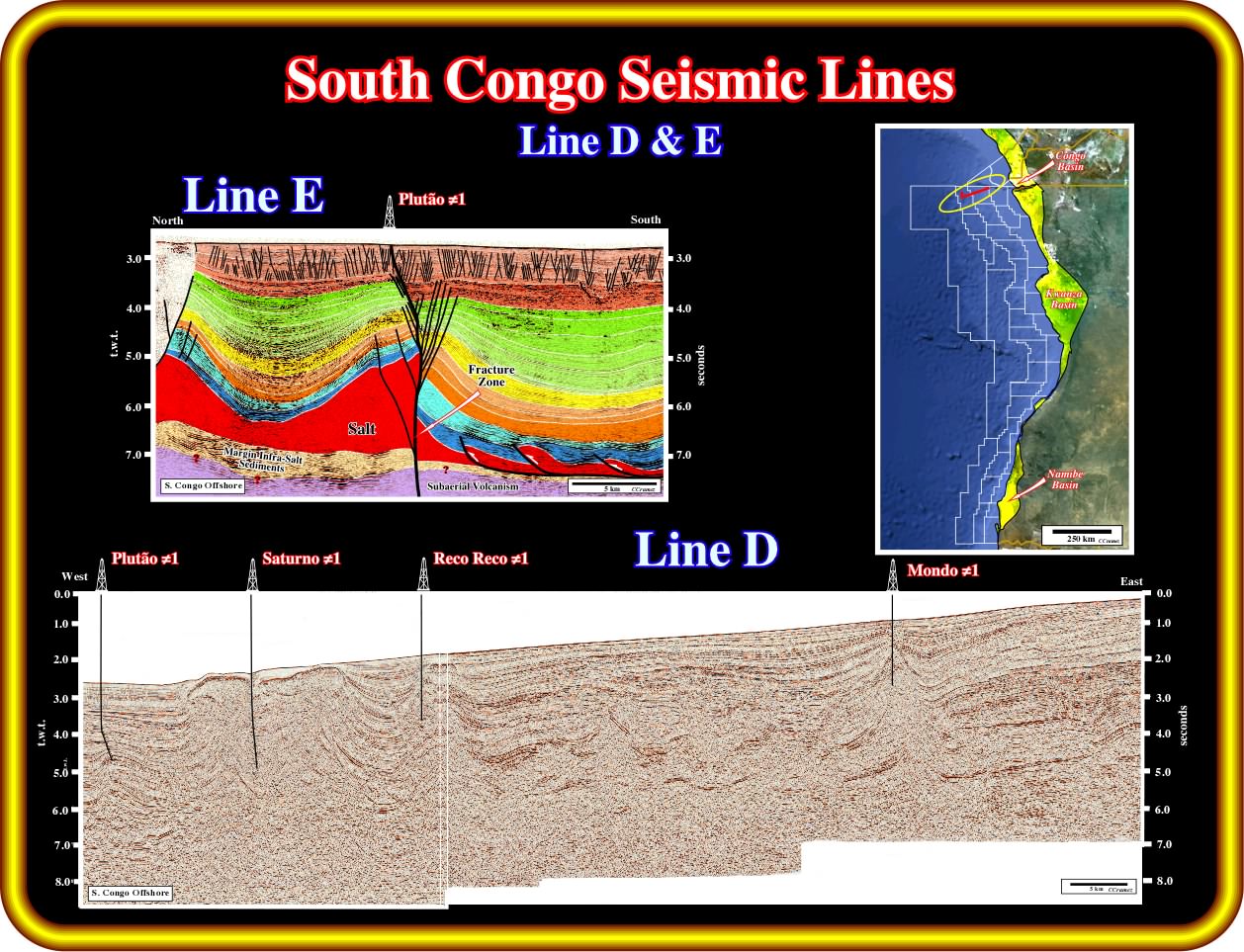
These seismic lines, shot no far from the previous, depict, more or less, the same geological events point out previously. As illustrated Plutão well tested a compressional traps (morphological by juxtaposition) associated with a major fracture zone (probably the same fracture zone illustrated on the previous regional lines of South Congo Basin), which clearly displace the bottom of the salt. Using the line D, propose a geological tentative interpretation concentrating it on the picking of the salt layer and infra-salt strata. Advance bold interpretations on the facies and age (pre or post-breakup of the Gondwana lithosphere) of the infra-salt intervals and set forth the main consequences.
Exercise 2:
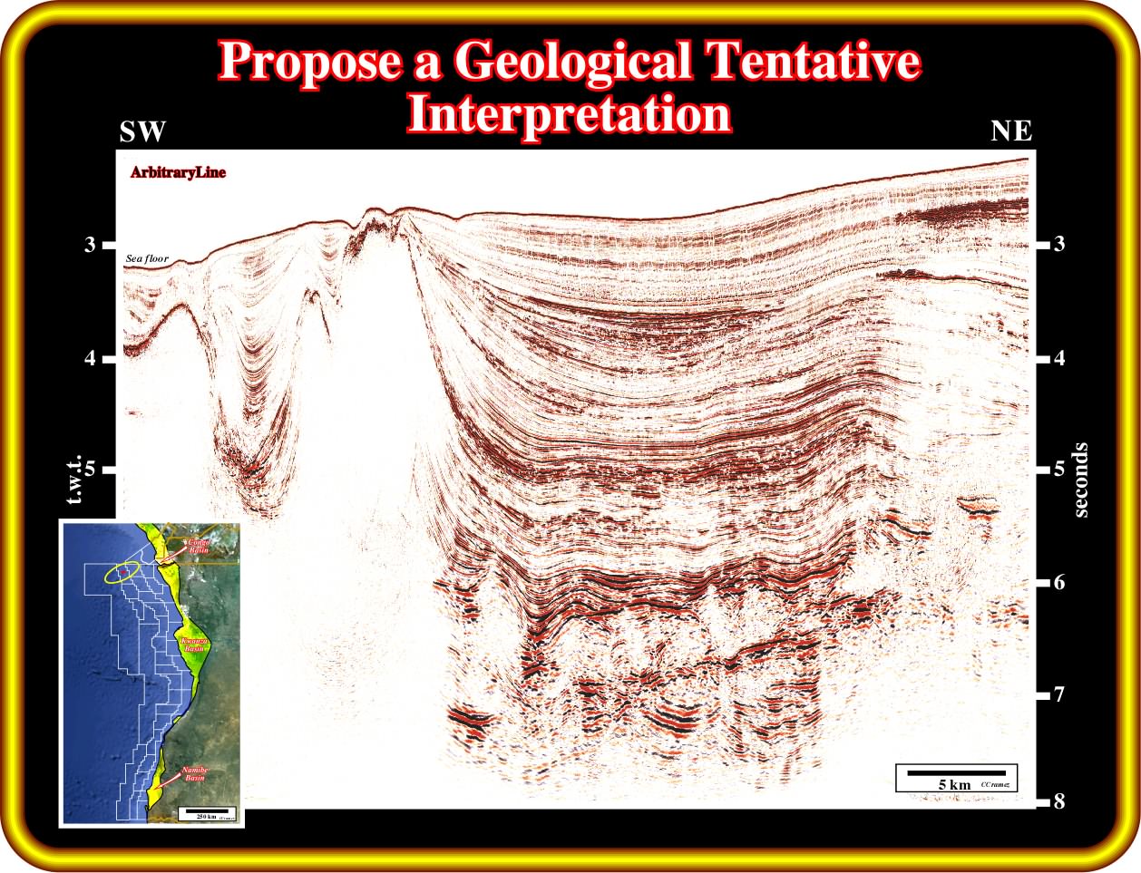
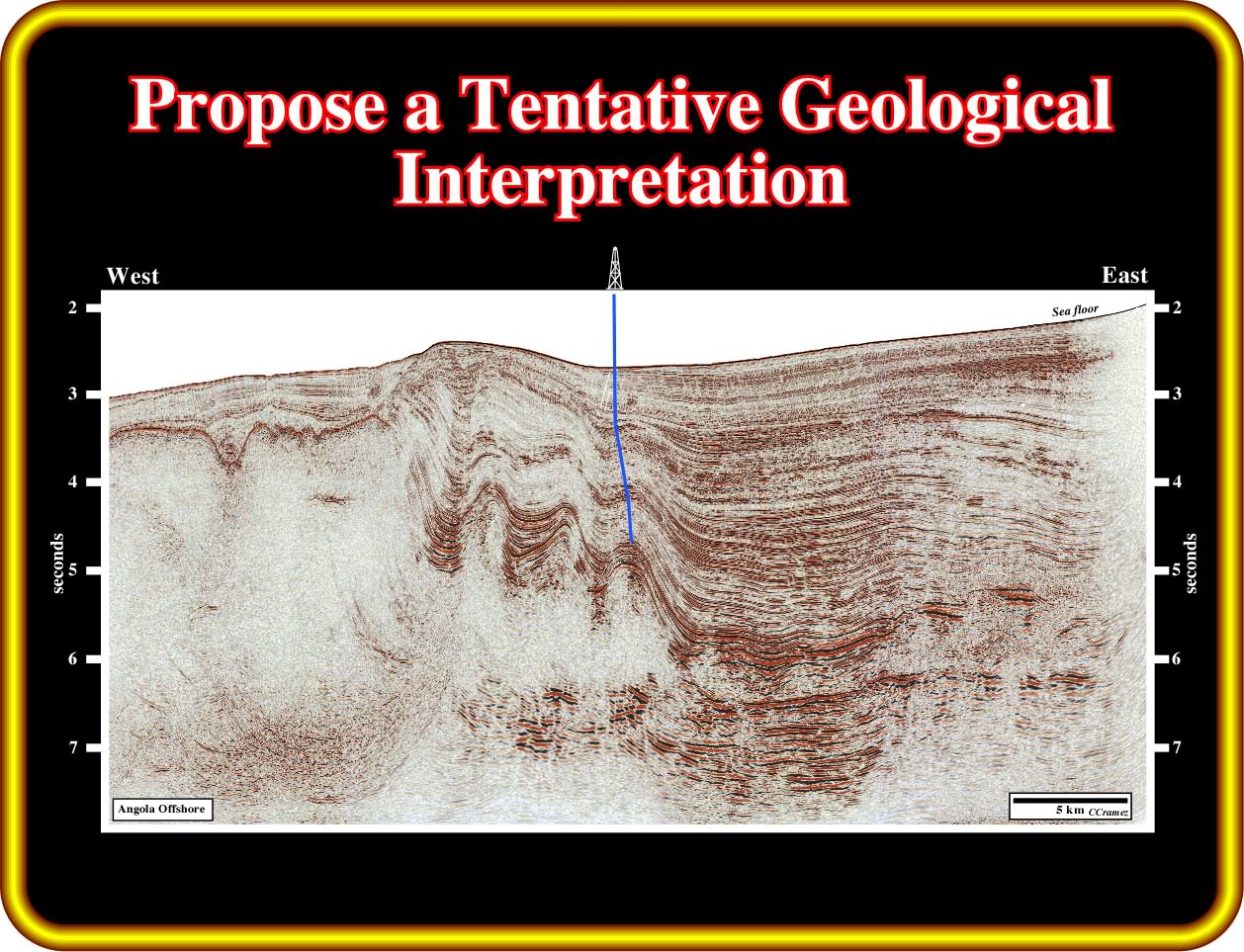
On this seismic line, located not far from the previous ones (South Congo Offshore), propose a geological tentative interpretation particularly of (i) the lower supra-salt sediments, which can induced seismic artefacts ; (ii) the salt layer and (iii) the infra-salt strata. Try to locate a major fracture, which displaced, vertically, the salt induced tectonic disharmony and which reactivation developed compressional structures.
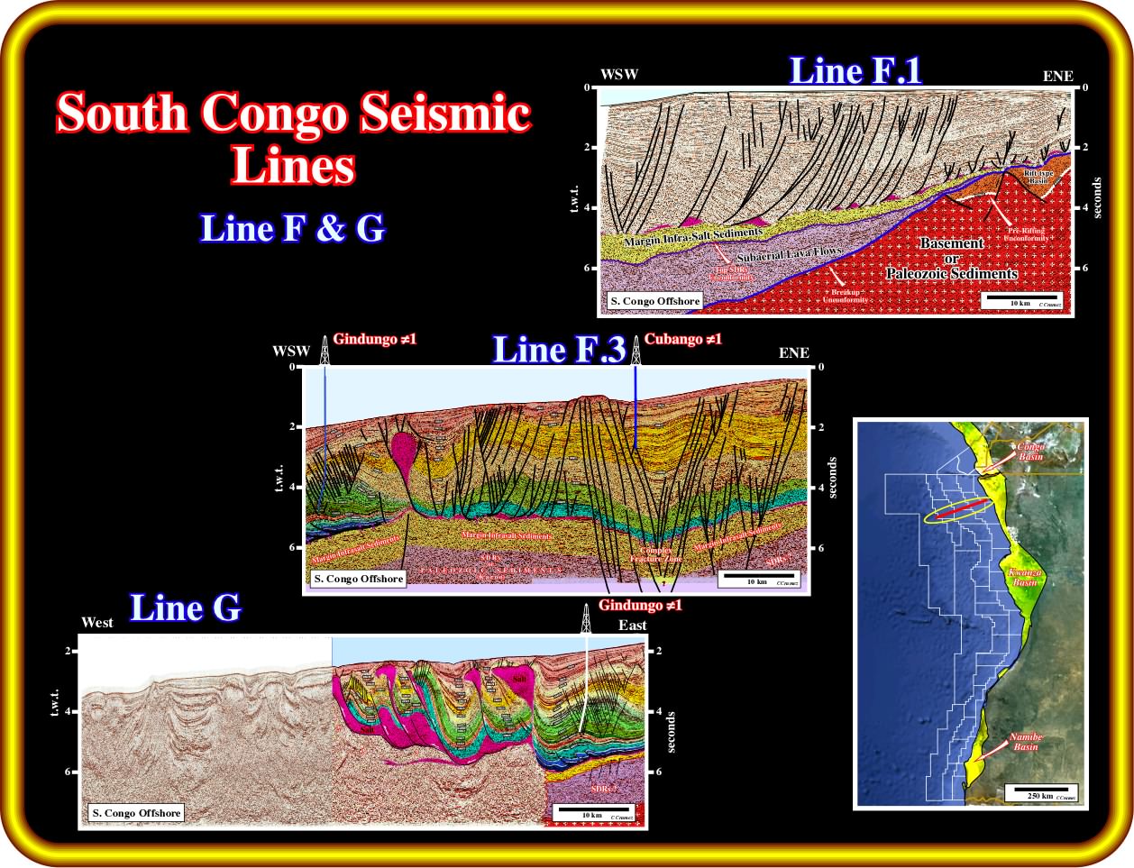
This three seismic line can be grouped, as indicated on the location map, to form a regional composite line. In fact, Gindungo well is clearly recognized on line G and line F.3. The line F.2, located between the lines F.3 and F.1 was omitted for space reasons. In any way whatsoever, the seismic interval recognized in the area of Cubango well are easily followed eastward and correlated with those picked on line F.1, which is located mainly in the continental platform. The proposed geological tentative interpretations imply the following remarks : (i) The clear evidence of two rift-type basins in the continental crust on the eastern par of the seismic line F.1 ; (ii) The presence of the breakup unconformity at the top of the rift-type basins and the bottom of the post-breakup volcanic material (in purple on the tentative interpretations) emplaced at the bottom of the margin ; (ii) The likely emplacement of a subaerial volcanic crust (not reached by drilling in this area) after the breakup of the Gondwana lithosphere above and outward of the continental crust ; (iii) An huge depocenter of margin infra-salt sediments (not yet recognized by drilling), in which organic rich sedimentary intervals cannot be excluded, i.e., in which potential source-rocks and a potential petroleum system are likely ; (iv) Major fractures zones affect the geometry of the bottom of the salt layer and focalize the sedimentary shortening induced by the compressional tectonic regimes developed in the margin during the Late Cenozoic ; (v) Above the salt induced tectonic disharmony, the main geological events are the same recognized on the previous lines.
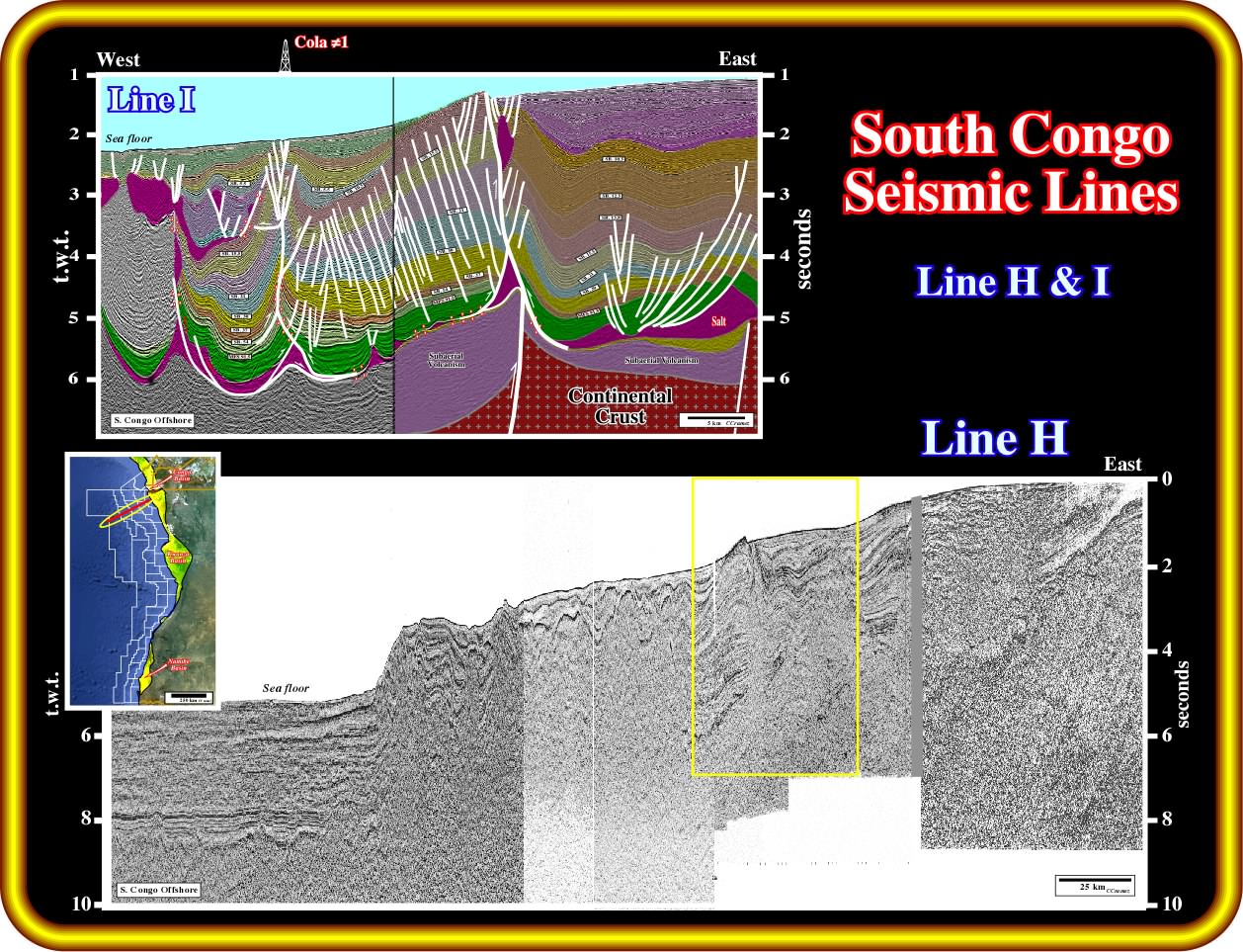
This regional composite seismic line give evidence of : (i) The late Tertiary uplift of the eastern part of the line (continental platform) ; (ii) The continental crust with rift-type basins, in the eastern part, under the continental platform ; (iii) The oceanic crust, that is to say, the volcanic material emplaced, after the breakup of the Gondwana lithosphere, under a significant water-depth (volcanic material does not flow under the water) ; (iv) The Angola escarpment, which is induced by a salt nappe (allochthonous salt) developed in association with the thickening of the salt, by thrusting, near the western edge of the salt basin ; (v) The folded belt, located above and eastward of the Angola escarpment, which is clearly associated with the shortening of the salt layer ; (vi) A probably subaerial volcanic crust (lava flows with a geometry of seaward dipping reflectors, between the oceanic and continental, which boundary a difficult to locate ; (vii) The late Tertiary reactivation of the major fracture zones as the one underlined by the yellow rectangle, which strongly affect the morphology of the bottom of the sea, as illustrated on the geological tentative interpretation illustrated above ; (viii) Primary, secondary and tertiary salt welds are visible on the proposed geological tentative interpretation of the composite line (line I) passing through Cola well, which corresponds to a squeezed diapir ; (ix) The compressional reactivation of the major fracture zone is well visible on the morphology of the sea floor ; (x) Margin infra-salt sediments are likely in the lower part of the line, below the tectonic disharmony, as well as subaerial volcanism above a potential continental crust.
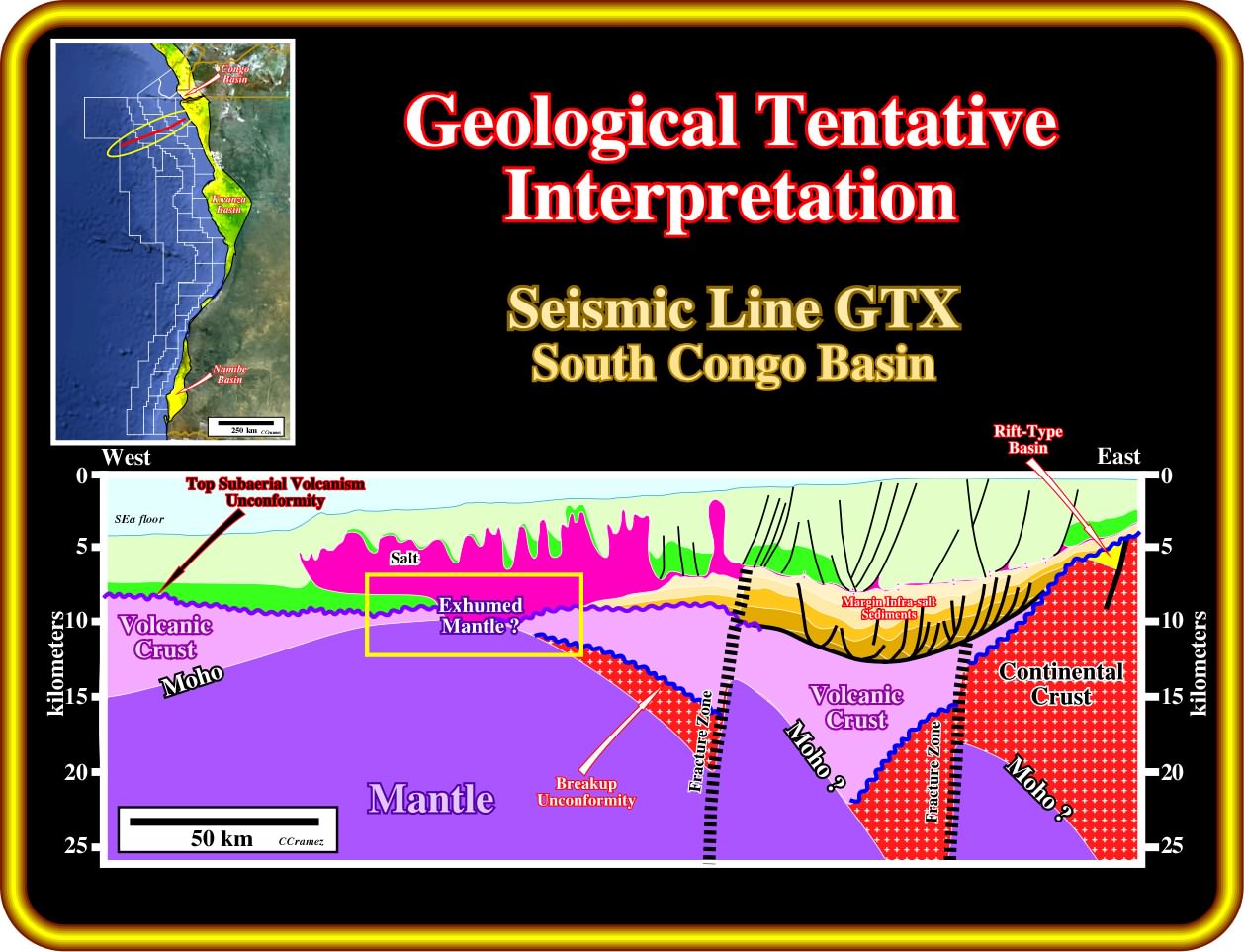
On this geological tentative interpretation of a GTX line located northward of the Ambriz arch, i.e., in the South Congo offshore, several geological conjectures are assumed : (i) The presence of rift-type basins within the continental crust, developed during the lengthening of the lithosphere before the breakup ; (ii) The breakup unconformity, located at the top of the rift-type basins and bottom of the subaerial volcanic interval (probably lava flows dipping and thickening seaward) deposited immediately after the breakup of the lithosphere by intrusion of mantelic material ; (iii) The presence of major fracture zones, which strongly displaced the breakup unconformity and, in certain cases, even the unconformity located at the top of the post-breakup subaerial volcanism ; (iv) The presence of a huge margin infra-salt depocenter, in which several seismic interval can be recognized using the reflection terminations ; (v) The lower seismic intervals of the margin infra-salt depocenter were affected by a post-sedimentary lengthening, with formation of half-grabens, particularly in the lowermost interval, due to the volume problem created by the subsidence, responsible for the accommodation (space available for the sediments), since, here, the eustasy is insignificant ; (vi) Such a post depositional half-grabens should not be confounded with rift-type basin, which correspond to synsedimentary structures associated to the lengthening of the continental crust, in other words, all rift-type basins are half-grabens, but not all half-grabens are rift-type basins, as we will see late (e.g., in Syria onshore, all geoscientists, know the Euphrates graben, none of them call it Euphrates rift-type basin) ; (vii) Exhumation of the mantle near the western edge of the salt basin ; (viii) The conjectures assumed for the salt and overburden are the same proposed previously.
Exercise 3:
After proposing a geological tentative interpretation, that you must make plain and comprehensible, answer the following questions :
- How many tectonic regimes can you recognized on this seismic line ?
- Are the sediments shortened or lengthened ?
- The salt was deformed by halokinesis (equilibrium tectonic regime, with a tectonic stress nil) or by another tectonic regime or by both ? Explain you answer.
- How the allochthonous salt was developed ?
- Did you recognize the breakup unconformity ?
- How do you interpret the infra-salt strata? Justify your answer.
to continue press
next
![]()