
Let's see now, few offshore seismic lines southward of the Ambriz arch, that is to say, from Kwanza basin offshore.
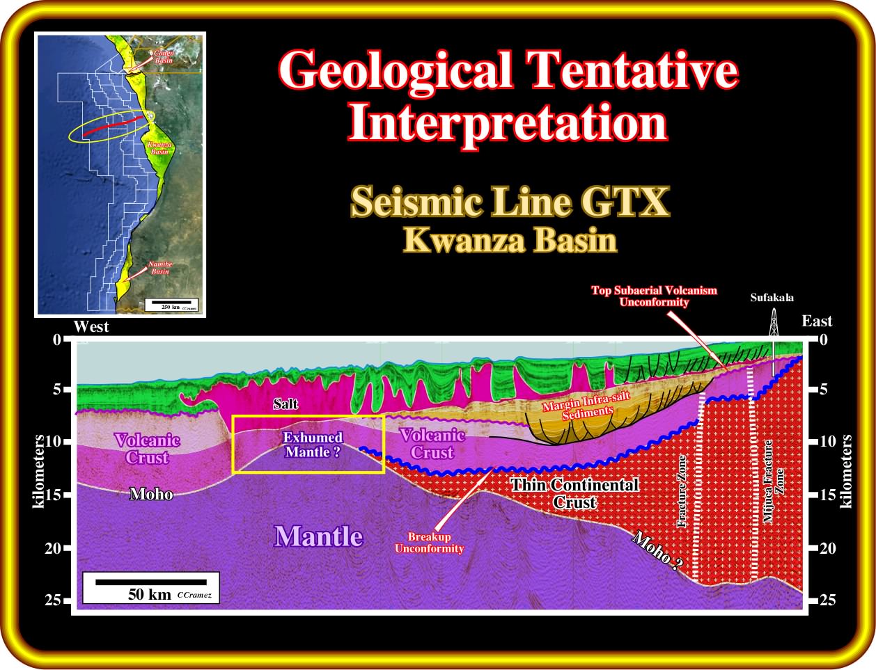
On this geological tentative interpretation of a GTX seismic line, more or less, parallel to the Ambriz arch, one can recognize the same geological events predicted, previously, on the tentative interpretation of the GTX line located northward of the Ambriz arch : (i) The presence of rift-type basins within the continental crust, is not corroborate on this seismic line ; (ii) The breakup unconformity is, here, located at the top of the subaerial volcanic interval, recognized here, by Sufakala well ; (iii) The presence of major fracture zones affecting the breakup unconformity and post-breakup subaerial volcanism ; (iv) The presence of a huge margin infra-salt depocenter ; (v) The lower seismic intervals of the margin infra-salt depocenter are affected by a post-sedimentary lengthening, with formation of half-grabens ; (vi) The post depositional half-grabens do not correspond to rift-type basin, which are developed in association with the lengthening of the continental crust (similar thin-skinned extensional structure associated with the subsidence history are well known in Vienna and Danube basins) ; (vii) Exhumation of the mantle near the western edge of the salt basin ; (viii) Raft tectonics is present in the supra-salt sediments in the eastern part of the line ; (ix) A significant thickening by thrusting is visible near the western edge of the salt basin, which seem to correspond to a normal fault or to a great topographic anomaly on the subaerial volcanic crust (why not a pile up of lava deltas).
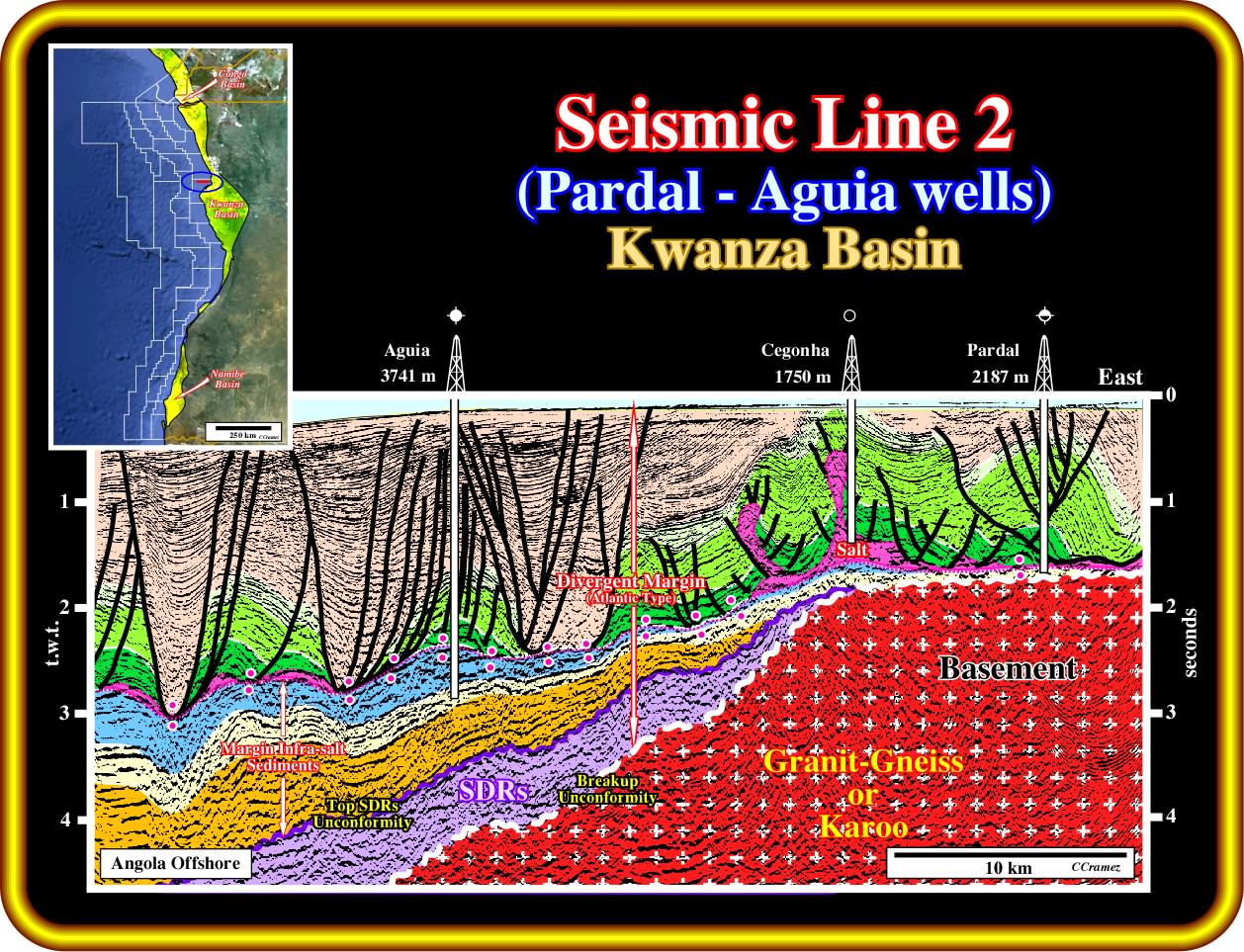
On this geological tentative interpretation of a seismic line from the Kwanza basin offshore (not far from Luanda), the interpreter took into account the seismic artefacts induced by the lateral variation of interval velocity created by the supra-salt Tertiary depocenters (low velocity) as carbonate second order rafts (high velocity). Consequently, below the salt-induced tectonic disharmony, any rift-type basin is evident. On the contrary, two major seismic intervals are proposed. From bottom to top they are: (i) An subaerial volcanism, probably lava flows as those recognized in surrounding exploration wells (Flamingo, Sukafala, Mubafo, etc.), which overlies the breakup unconformity, here located at the top of basement, which, here, correspond to Precambrian granite-gneiss or Karoo sediments (non-marine and consisting of shales, red beds, siltstones, and great quantities of volcanics, which age ranges from Carboniferous and Permian period, i.e., 359 - 251 Ma to the Late Triassic Epoch, i.e., ± 229-200 Ma) and (ii) A thick margin infra-salt depocenter, partially recognized by Aguia well. The generating petroleum potential of the subaerial volcanism, in which, more or less thick, sedimentary layers can be interbedded, is most likely is nil. On the contrary, a petroleum system is possible within the margin infra-salt sediments, since reservoir and source-rocks (sandstones and reefal limestones) were found in Aguia well just like hydrocarbon shows. It is interesting to notice that in the eastern part of this line, near Cegonha well, the volcanic interval pinchouts, and the thickness of the margin infra-salt depocenter becomes quite small and often under seismic resolution. The main petroleum problem of infra-salt strata is the presence or no volcanic interval, which, practically, has no generating petroleum potential, and in case of its presence, is the limit between it and overlying margin infra-salt sediments, in which the occurrence of a petroleum system is quite likely. Summing up: (i) If the infra-salt strata dips continentward infilling half-graben structures, they correspond, probably, to rift-type basins with generating petroleum potential when the internal configuration parallel (lacustrine shales) and without generating petroleum potential when the internal configuration is divergent toward the bordering normal fault (mainly sandstones) ; (ii) If the infra-salt strata dip seaward, likely, they correspond margin infra-salt sediments when proximal and distal onlaps area recognized, as in a Depocenter, or to subaerial volcanic material when distal onlap relationships do not exist, i.e., the lava flows thickening seaward till the spreading centres. In the last case, and contrariwise to the first one, the top of the volcanic interval can show progradational topographic anomalies, often, associated with lava deltas.
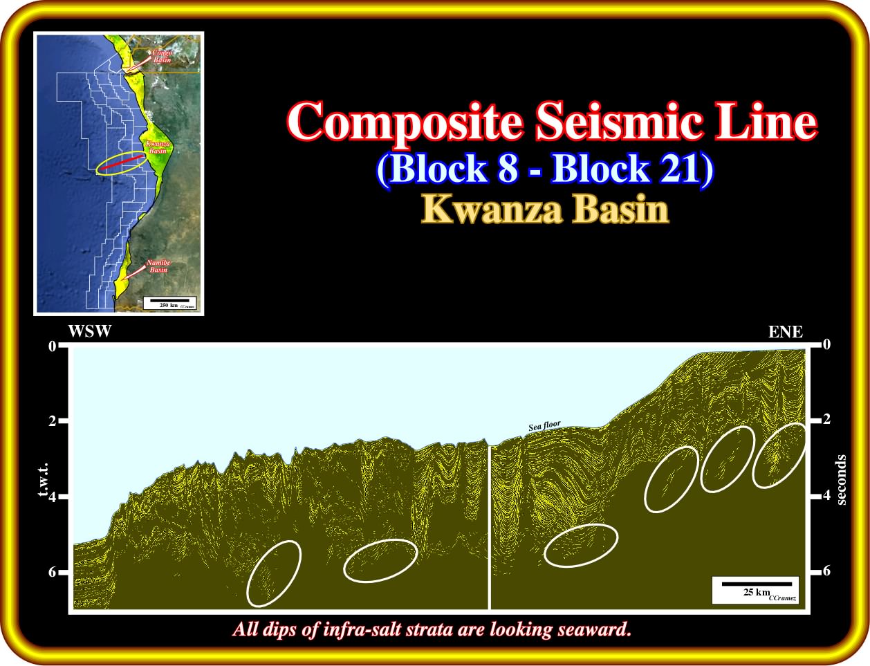
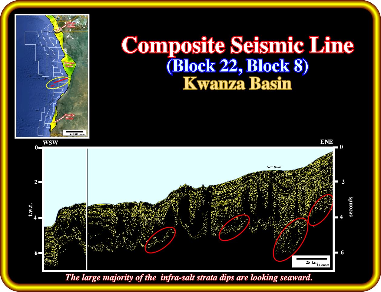
As illustrated on this schematic seismic line (the principal seismic reflector were enhanced by pencil lines), below the salt-induced tectonic disharmony (bottom of the salt layer and associated primary salt welds), the visible seismic marks dip all seaward. Consequently : (i) The absence continental crust is likely, since the stratigraphic and structural signature of the rift-type basins is not present (rift-type basin can only exist within the continental crust, since they develop during its lengthening before the breakup of the lithosphere) ; (ii) In the absence of distal onlaps (onlaps looking landward, as in the western edge of a margin infra-salt Depocenter), the seaward dipping reflectors have more chances to correspond to volcanic that sand-shale facies.
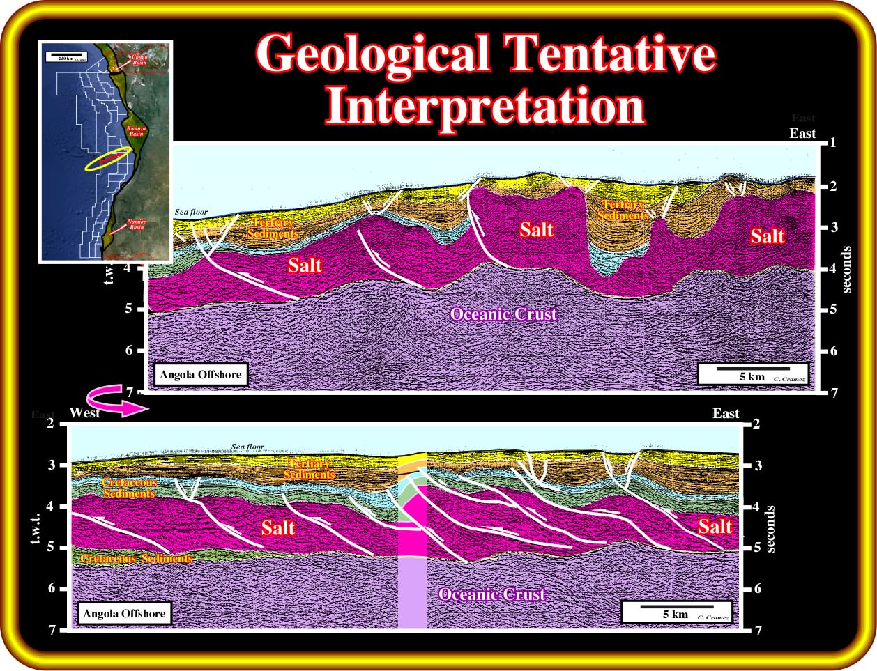
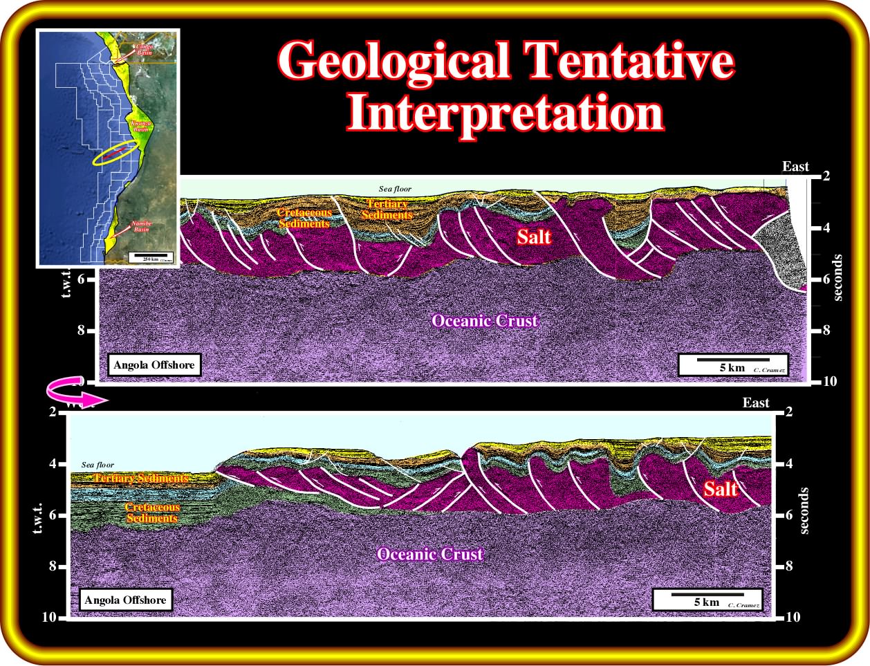
This geological tentative interpretation of a seismic line (the lower line is the continuation of the upper one), clearly illustrates that there is no obvious seismic intervals below the salt layer. The more likely and coherent with the regional geological setting of the basin is to consider that the salt interval, which is strongly shortened, as well as the Cretaceous overburden, overlies volcanic material, that is to say, oceanic or subaerial crust. Notice the possible presence of cretaceous sediments below the salt in the western part of the lower line, which implies , in this area, a certain allochthony of the salt.
 HCPotentialInfraSalt2/Images/Plate009.5-AbacaxiLine.jpg)
The geological tentative interpretation of the seismic line passing through Abacaxi and Maboque well, one can realize that the infra-salt strata can be subdivided into three different seismic packages : (ii) The lower one, deposited above the breakup unconformity, which in this area lies on the top of the basement, is, probably, formed by volcanic material (lava flows) emplaced after the breakup of the Gondwana unconformity ; (ii) Overlying the supposed subaerial volcanic interval, a thick margin infra-salt interval, was deposited, which can be subdivided in a lower and upper member, individualised by a local unconformity. The rift-type basin visible in the eastern part of the seismic line are clearly pre-dating the breakup unconformity. The generating petroleum potential of a such rift-type basins is, practically, inexistent since the size of the rift-type basins is too small to allow the development of lacustrine organic rich shales. The Abacaxi well, in the infra-salt strata, recognised hydrocarbon potential of the margin infra-salt sediments above subaerial volcanism. Maboque well reached the continental crust (granite-gneiss).
On this seismic seismic line (the lower section is the continuation of the upper one) located in the southern part of the Kwanza offshore(exploration blocks 8, 22, 23), as suggested by the proposed geological tentative interpretation there is no evidence of continental crust (where rift-type basins are likely) below the evaporitic interval, which is here quite shortened by faulting (sediments can just be shortened by folding and /or by reverse faulting). On the other hand, is there margin infra-salt sediments their thickness is under seismic resolution. In fact, a volcanic crust is by far the the more likely substratum of the salt. Oceanic crust is more than likely in the western end of the line, below and westward of the salt allochthonous nappe, while a subaerial volcanic crust, mainly composed by lava flows, is possible in the central and eastern parts of the line.
On this representation of a seismic line passing through the exploration blocks 9 and 23, the boundaries of the evaporitic interval, which mainly composed by halite, but in which interbedded sandstone layers cannot be excluded (as it is the case in Cabinda offshore, for instance) are easily recognized, as well as the Angola escarpment with the associated salt-induced fold belt. Taking into account the seismic artefacts, induced by the lateral variations of the salt thickness and depocenters of the overburden, one can notice that most of the infra-salt seismic reflectors dip seaward what favour the hypothesis of a volcanic substratum.
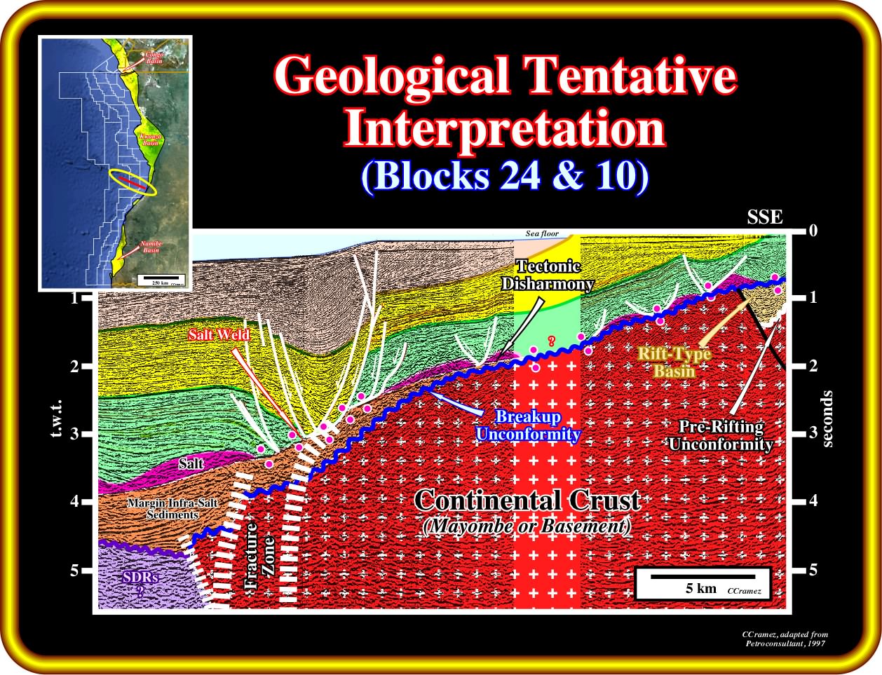
This geological tentative interpretation of seismic line is located in the southernmost part of the Kwanza basin (Benguela basin for certain geoscientist). It recognizes the exploration blocks 10 and 24. A major fracture zone is easily recognized. Such a fracture zone seems to limit the continental crust, in which rift-type basin is readily recognized, from the volcanic crust (probably subaerial). The movements along the fracture zone seem to determine the limit of the continental platform, as well as a significant depocenter in the supra-salt strata. Above the breakup unconformity (wavy blue line in this tentative interpretation) and below the salt or associated salt welds, margin infra-salt sediments are present. The thickness of the margin infra-salt interval seems to be controlled by motion of the fracture zone.
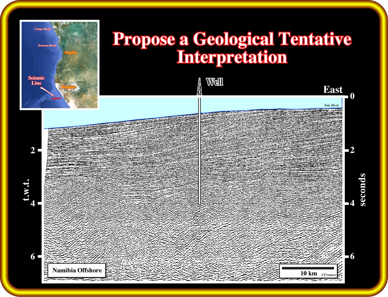
Exercise 1:
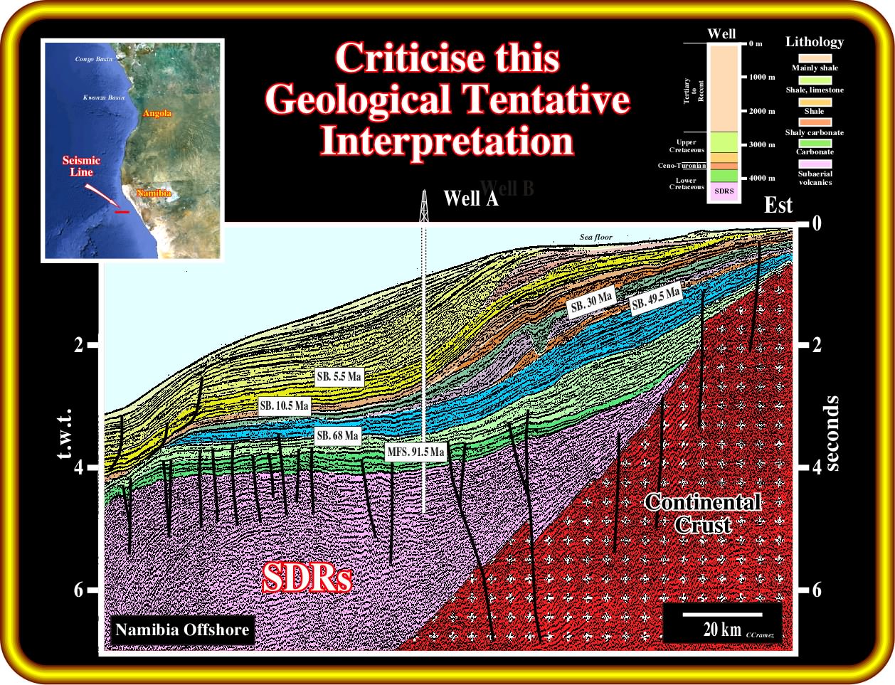
This geological tentative interpretation of a seismic line of Namibia offshore (no evaporites were deposited) was calibrated by results of the well A. The main lithological interval are summarized on the sketched illustrated in the upper right corner of the plate. Criticize the tentative interpretation. Propose an explanation of the internal configuration of the different seismic intervals. Do you recognize a petroleum systems on this tentative interpretation. Justify your answer.
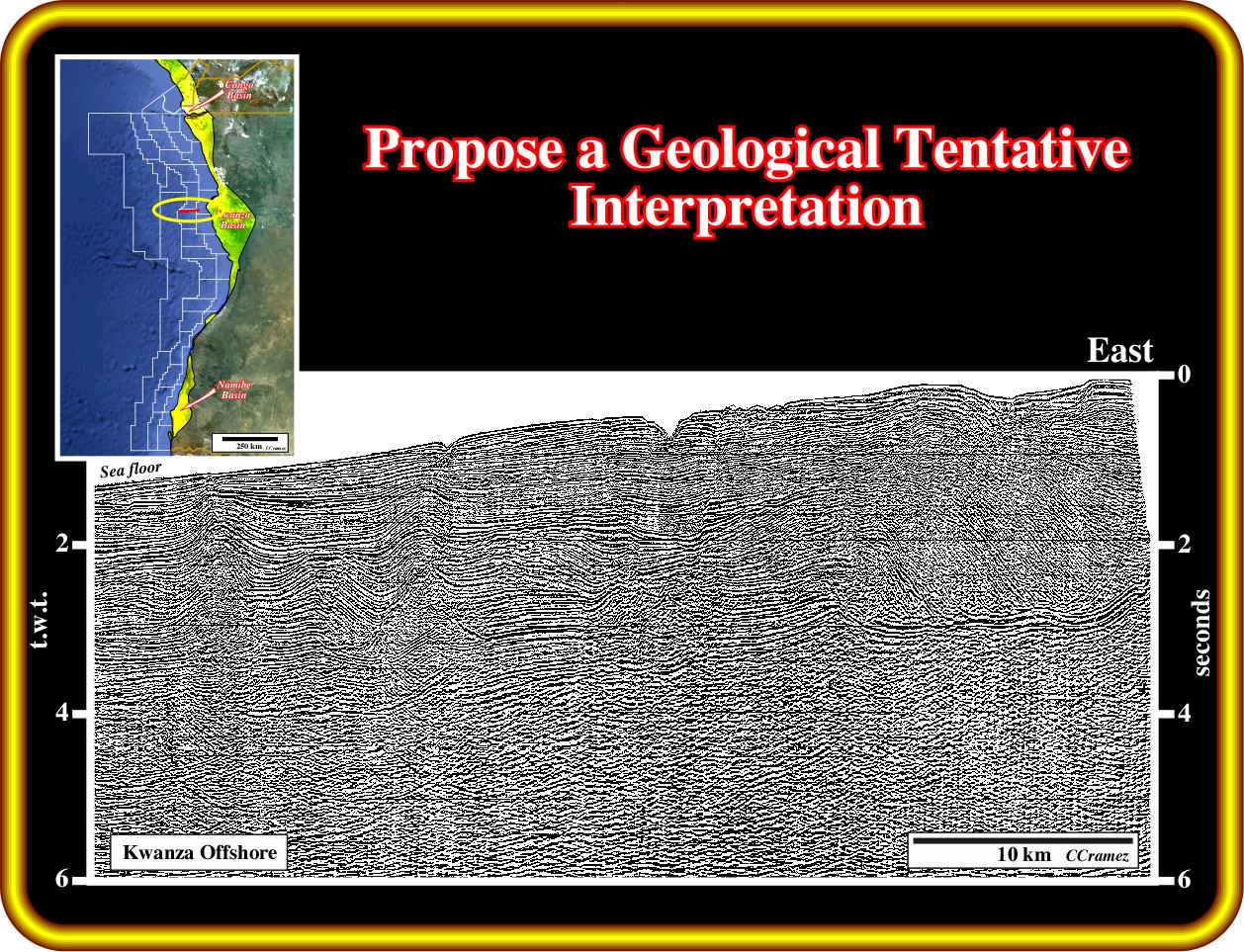
Exercise 2:
Propose a geological tentative interpretation of this seismci line, which is located few kilometers soutward the line of the exercise 1.
Exercise 3:
Propose a geological tentative interpretation of this Kwanza offshore seismic line giving particular attention to the infra-salt strata. Then, propose two potential petroleum systems (supra and infra-salt) indicating the best location to test them.
to continue press
next
![]()