
Universidade Fernando Pessoa
Porto, Portugal
Abstract:
The recognition of SDRs, i.e. seaward dipping reflectors, on several seismic lines of the western and eastern offshore India, suggest that the breakup of the lithosphere and the onset of the sea-floor spreading were similar to those proposed to the South Atlantic. The observed seaward dipping reflectors are interpreted as sub-aerial lava flows post-dating the breakup unconformity. In such an hypothesis the onset individualization of the India continent from the Gondwanaland can be summarized by two phase which have huge exploration significance.
Rifting or Stretching Phase: The lithospheric plates that assembled to form Pangea comprised highly variable continental crust. Their diverse shapes ensured that the assembling continents collided along complex and misfitting suture zones. These collisional seams of weaker crust influenced the pattern of breakup during dispersal of Pangea. Lithospheric breakup of Pangea has been closely linked to underlying mantle plumes. Each plume of upwelling asthenosphere heated, elevated and stretched a dome of overlying lithosphere. Stretching created asymmetric basins along the axis of the future oceans. Like many other geological structures, rift basins are scale invariant. The internal configuration and facies of these asymmetric basins depended mostly on the relative rates of extension (which created accommodation space) and sedimentation, (which filled space).
Breakup Volcanism Phase: As the lithosphere thinned by stretching and heating, igneous activity became increasingly common over time and nearer to the axis of rupture. After stretching continental crust to a b factor of
≈2, abundant gabbroic melts were emplaced as dike swarms and sills in the stretching crust. Eventually, before reaching a theoretical limit of
Hydrocarbon implications: The breakup (BU) unconformity cutting across the rift-type basins is prominent on most seismic profiles on divergent continental margins. The BU unconformity represents a period of inversion, uplift, and erosion along the continental margins. This change in stress regime has been linked with either intraplate stresses induced by a change in plate kinematics or with the onset of ridge-push forces, which converted deviatoric tension to deviatoric compression on the diverging continental margins. The BU unconformity is an important exploration marker for the end of rifting. The geometry of the unconformity is commonly unmistakable in the proximal and central parts of the continental margins. Problems arise in identifying the BU unconformity more distally below the present deep-water slope. There, the clearest angular unconformity separates SDRs (subaerial flood basalts rotated by cooling) from more-gently dipping reflectors above. However, this SDR unconformity is not the BU unconformity, and it can postdates breakup by many millions of years. The true time equivalent of the BU unconformity is the base of continuous flood basalts extruded during the initially subaerial creation of oceanic crust. Misinterpreting the two types of unconformity has huge exploration significance. The BU unconformity overlies continental crust or rift basins, which have potential source rocks. In contrast the SDR unconformity is underlain by subaerial lava flows whose thickness can be thousands of meters Except for the proximal regions of the first subaerial volcanic flows, which onlap the continental crust, no generating petroleum subsystems are present within or below the SDRs. Apart from condensed sections immediately above the SDR unconformity, most overlying strata are likely to be Tertiary and thus much younger than the underlying lava flows.
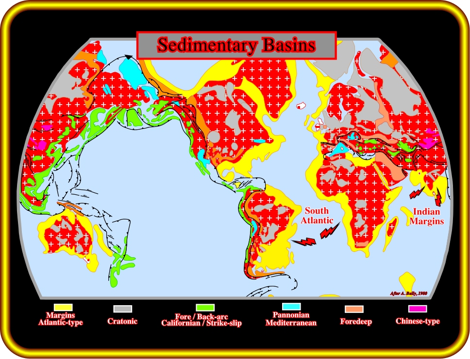
Plate 1- The recognition of seaward dipping reflectors (SDRs) on offshore seismic lines of Western and Eastern India suggest that the breakup of the lithosphere and the onset of the sea-floor spreading were similar to those proposed for the South Atlantic. The SDRs are interpreted as sub-aerial lava flows post-dating the breakup unconformity, which separates two major tectonic phases associated with the type-rift basins and the overlying continental divergent margins. As illustrated on this plate , which represents the post-Pangea sedimentary basins, according to A. Bally and S. Snelson. The South Atlantic and the India offshores correspond to Atlantic type divergent continental margins (in yellow on the plate) overlying type-rift basins. Such a basin classification can easily be recognized on the sea-bottom morphology (next plate).
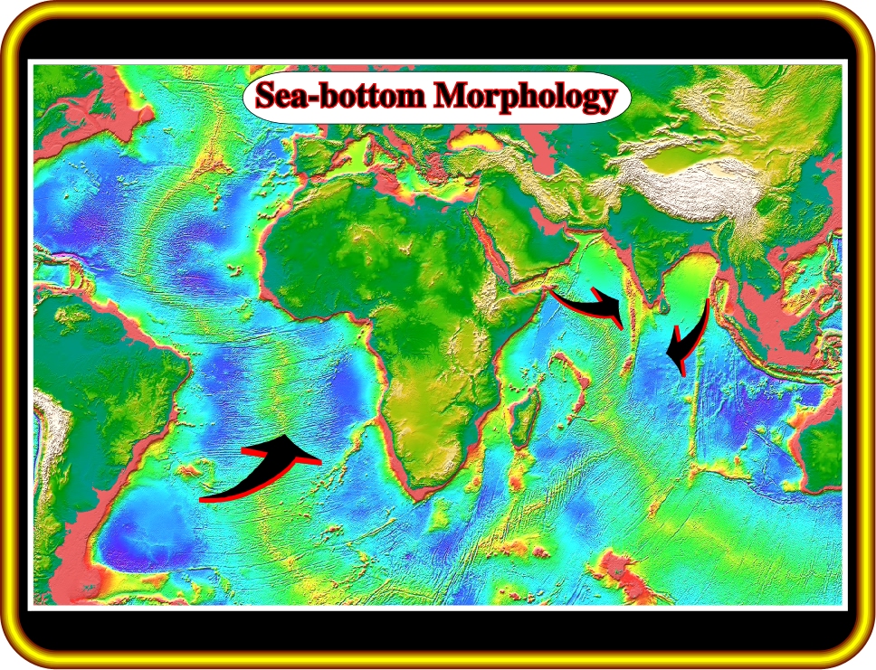
Plate 2- Assuming a constant gravitational force since the birth of the Earth, or in other words, assuming that the Earth’s volume has been constant, a back-stepping reconstruction along the active and inactive transform faults recognized on the sea-bottom morphological map, strongly suggests a Supercontinent with a large gulf on the eastern part, at the end of the Paleozoic time .
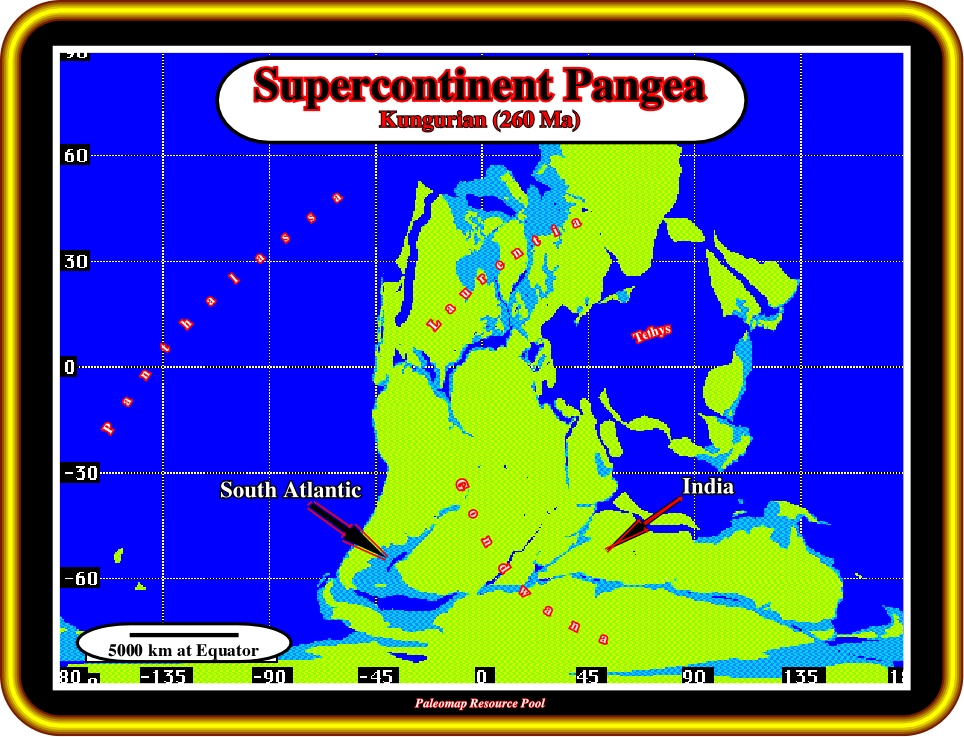
Plate 3- The supercontinent was labeled Pangea and the gulf, Tethys Sea. As illustrated, the Paleozoic supercontinent was surrounded by the Panthalassa, the big ocean, and composed by two major continents: (i) - The Laurentia, on the north part, and (ii) - The Gondwana, on the south part. The forerunners of the South Atlantic and India offshores were part of the Gondwana continent. Consequently, the creation of these offshores is associated with the breakup of the Gondwana.
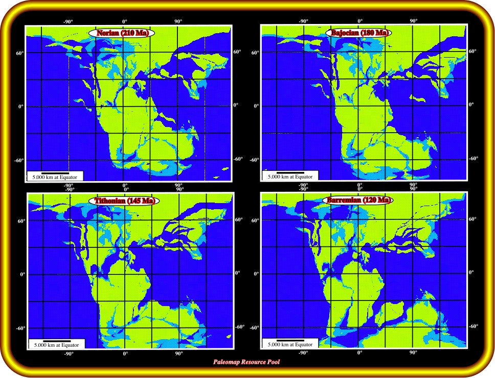
Plate 4- The breakup of the Pangea and the onset of sea-floor spreading depicted here suggests for the South Atlantic and India offshores: 1) A similar age and 2) A similar geological model. Let’s summarize the geological model proposed two years ago for the South Atlantic offshores by TotalFinaElf.
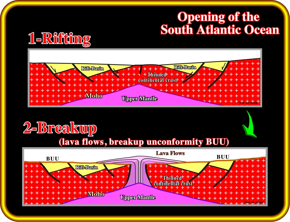
Plate 5- Rifting Phase (135-115 Ma): Lithospheric breakup of Pangea has been closely linked to underlying mantle plumes. Each plume of upwelling asthenosphere heated, elevated, magmatically underplated, and stretched a dome of overlying lithosphere. Stretching created asymmetric rift-type basins along the axis of the future ocean. Breakup Volcanism (135-130 Ma): As the lithosphere thinned by stretching and heating, igneous activity became increasingly common over time and nearer to the axis of rupture. After continental crust was stretched to a b factor of
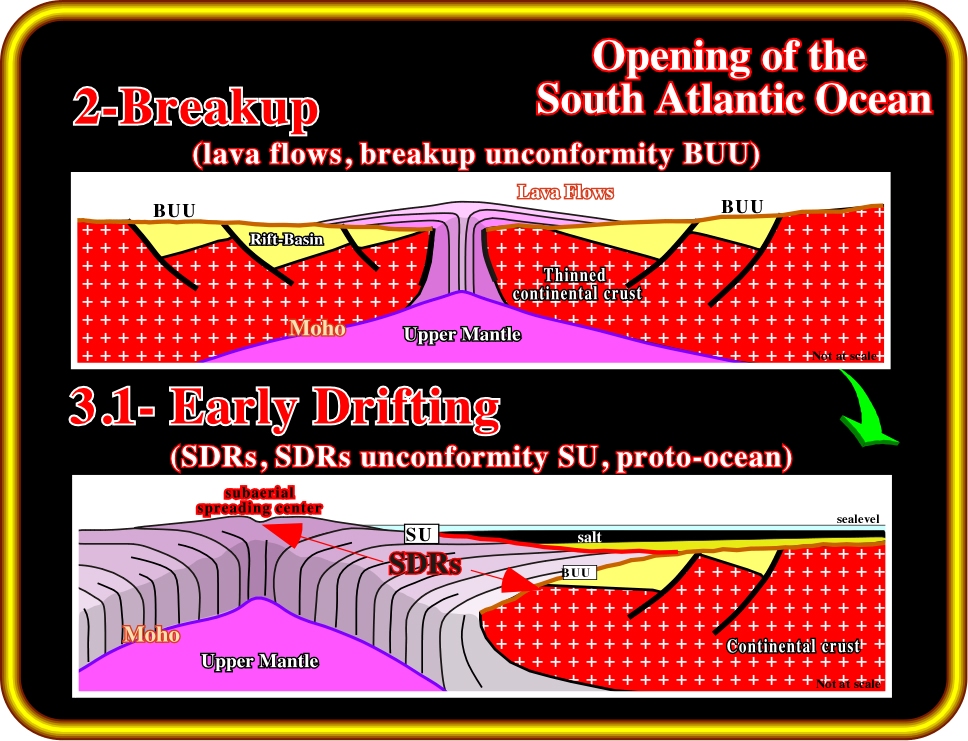
Plate 6- Lavas flowed from spreading centers toward the continent across the distal rift-type basins. For the most part, subaerial spreading centers poured out extensive lavas that flowed and thinned toward the continent. Vertical stacking of flows masks magnetic reversals including those in the underlying sheeted dikes, so this type of basaltic crust is magnetically quiet. As the underlying lithosphere cooled, thermal subsidence lowered the lava flows below sea level. Environments became marine, and the spreading center submerged to become an oceanic ridge. Lava flows no longer flooded laterally because they froze rapidly under the sea. The oceanic spreading center spread by injection of sheeted dikes. This geometry allows magnetic anomalies in submarine sheeted dikes to be more easily identified by potential field data than anomalies within or below the stacked subaerial flood basalts. At an early stage of submergence, marine circulation in shallow, irregular basins was restricted by tectonic and volcanic barriers. That favored formation of local evaporite basins that gradually coalesced as they deepened at about 115 Ma. Lithospheric cooling tilted the originally flat-lying lava flows seaward. The seismic signature of these cooled and rotated lava flows is seaward-dipping reflectors (SDR). Dipping reflectors have been known for some time, but only recently has drilling revealed the immense scale of these subaerial volcanic sequences: the province can be more than 100 km wide and 5-10 km thick. Previously, these vast subaerial volcanic terranes have been mostly interpreted as extensionally thinned continental crust because they show some seismic resemblance to rift-type basins and lack magnetic reversal anomalies. SDRs are visible on almost all regional lines in the South Atlantic, except where obscured by thick or complexly deformed salt.
![]()
Plate 7- Drifting Transgressive Phase (~115-85 Ma): Aptian evaporites or sandstones mark the onset of major transgression that continued until the end of the Cenomanian-Turonian. Transgression was driven partly by eustatic rise of sea level due to increased oceanic spreading rates, longer oceanic ridges, and previous stretching of continents during the breakup of Pangea. Local lithospheric cooling of the continental margins also caused them to drown. During transgression, a landward-thickening wedge was built by carbonate and siliciclastic units, while marine facies encroached landward as backstepping marine platforms bounded by the coastal break and shelf break.
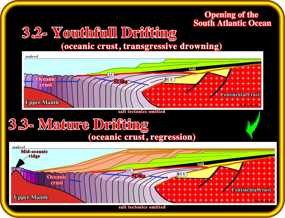
Plate 8- Drifting Regressive Phase (~60-0 Ma): Eustatic fall of sea level during the Tertiary was enhanced by epeirogenic uplift of continental crust. Each South Atlantic mar-gin widened by progradation of a regressive wedge. On seismic lines, this regressive phase is separated from the previous transgressive phase by a major downlap surface. Continental facies shifted seaward, and the coastal break merged with the shelf break. The regressive wedge thickened seaward, then tapered into deep water. Epeirogenic local uplifts of several kilometers were created within the continents by intraplate stress or by underlying igneous activity. The uplifts locally steepened the continental margins, and beveled major angular unconformities across them in the mid-Tertiary.
to continue press![]() next
next
![]()
Send E-mail to carloscramez@gmail.com with questions or comments about this conference.
Copyright © 2006 CCramez
Last modification:
August, 2014